干旱区研究 ›› 2022, Vol. 39 ›› Issue (4): 1259-1269.doi: 10.13866/j.azr.2022.04.26 cstr: 32277.14.AZR.20220426
张云霞1( ),张金茜1,2,巩杰1()
收稿日期:2022-01-26
修回日期:2022-03-04
出版日期:2022-07-15
发布日期:2022-09-26
作者简介:张云霞(1996-),女,硕士研究生,主要从事土地变化科学与景观生态研究. E-mail: 基金资助:
ZHANG Yunxia1(),ZHANG Jinxi1,2,GONG Jie1()
Received:2022-01-26
Revised:2022-03-04
Published:2022-07-15
Online:2022-09-26
摘要:
基于1980—2020年6期景观类型数据,分析了凉城县湖盆景观及其变化过程;利用景观敏感度指数和景观适应度指数构建了一种景观脆弱性综合指数,分析了县域景观格局脆弱性时空分异及其影响因素。研究表明:(1) 近40 a来凉城县景观类型变化差异明显。除未利用地外,1980—1995年耕地、林地及草地动态度最大,1995—2010年各景观类型动态度均较大,2010—2020年水域、建设用地动态度最大。(2) 1980—2020年全县景观格局脆弱性均以中、较高为主,面积达到70%以上,高值区集中分布在凉城中部和东南部,低值区位于岱海及其北部;景观脆弱性综合指数呈先下降后升高再下降趋势,区域生态环境开始好转。(3) 研究区生态环境脆弱性在不同景观类型、地形上差异显著。零散分布的林、草地脆弱性较高,水域最低;海拔<1300 m、坡度<5°的区域景观格局脆弱性最低,海拔1700~1900 m、坡度25°~40°区域的最高。(4) 总人口数、水域面积和耕地面积是湖盆景观格局脆弱性的主要影响因子;相对气候因子,人类活动对研究区生态环境的影响更大。因此,优化景观结构、减少过度扰动、保护水资源及水环境等,是降低凉城景观格局脆弱性和强化生态保护建设的主要手段。
张云霞,张金茜,巩杰. 半干旱区湖盆景观格局脆弱性及其影响因素——以凉城县为例[J]. 干旱区研究, 2022, 39(4): 1259-1269.
ZHANG Yunxia,ZHANG Jinxi,GONG Jie. Landscape pattern vulnerability and its influencing factors on a semi-arid lake basin: A case study of Liangcheng County[J]. Arid Zone Research, 2022, 39(4): 1259-1269.

图1
研究区概况示意图 注:底图采用自然资源部标准地图制作,审图号为GS(2021)5447号,对底图边界无修改。下同。"


图2
1980—2020年凉城县景观类型空间分布"
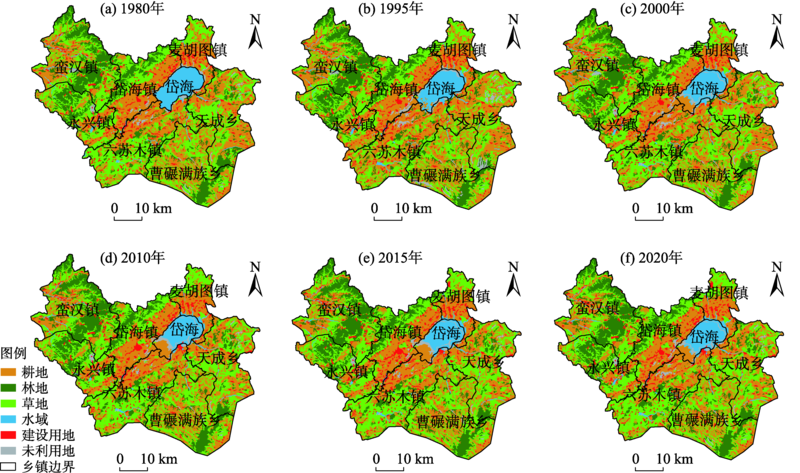
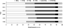
图3
1980—2020年凉城县各景观类型面积占比"

图4
1980—2020年凉城县单一景观类型动态度"
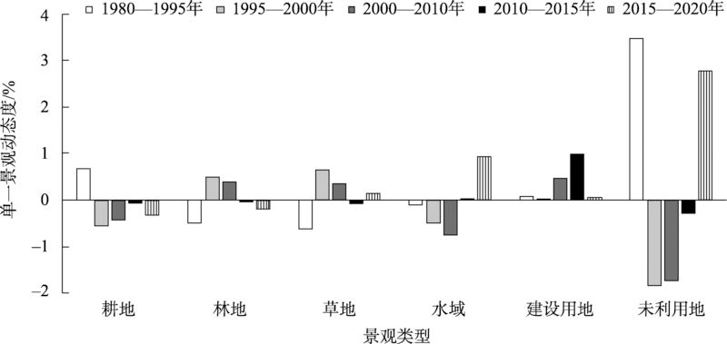

图5
1980—2020年凉城县景观脆弱性空间分布"

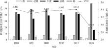
图6
1980—2020年凉城县景观格局脆弱性等级占比及LVII值变化"

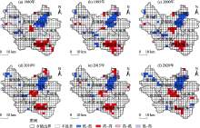
图7
1980—2020年凉城县景观脆弱度LISA聚集图"

表1
1980—2020年凉城县各景观类型LVI基本统计量"
| 耕地 | 林地 | 草地 | 水域 | 建设用地 | 未利用地 | ||||||||||||
|---|---|---|---|---|---|---|---|---|---|---|---|---|---|---|---|---|---|
| 最小值 | 最大值 | 最小值 | 最大值 | 最小值 | 最大值 | 最小值 | 最大值 | 最小值 | 最大值 | 最小值 | 最大值 | ||||||
| 1980年 | 0.122 | 0.721 | 0.167 | 0.639 | 0.135 | 0.721 | 0.037 | 0.500 | 0.176 | 0.699 | 0.184 | 0.595 | |||||
| 1995年 | 0.048 | 0.936 | 0.040 | 0.747 | 0.073 | 0.865 | 0.039 | 0.530 | 0.126 | 0.902 | 0.158 | 0.690 | |||||
| 2000年 | 0.072 | 0.728 | 0.054 | 0.622 | 0.126 | 0.644 | 0.061 | 0.476 | 0.154 | 0.686 | 0.203 | 0.551 | |||||
| 2010年 | 0.086 | 0.905 | 0.094 | 0.805 | 0.108 | 0.718 | 0.049 | 0.524 | 0.141 | 0.736 | 0.208 | 0.599 | |||||
| 2015年 | 0.115 | 0.836 | 0.106 | 0.709 | 0.141 | 0.703 | 0.056 | 0.506 | 0.144 | 0.745 | 0.227 | 0.565 | |||||
| 2020年 | 0.053 | 0.522 | 0.197 | 0.540 | 0.206 | 0.590 | 0.110 | 0.443 | 0.108 | 0.494 | 0.178 | 0.580 | |||||
| 变化 | 0.693 | 0.567 | 0.575 | 0.438 | 0.569 | 0.404 | |||||||||||
表2
1980—2020年凉城县各景观类型LVII值"
| 耕地 | 林地 | 草地 | 水域 | 建设用地 | 未利用地 | |
|---|---|---|---|---|---|---|
| 1980年 | 3.473 | 3.534 | 3.551 | 1.963 | 3.250 | 3.135 |
| 1995年 | 3.303 | 3.543 | 3.426 | 2.192 | 3.056 | 3.303 |
| 2000年 | 3.371 | 3.505 | 3.475 | 2.337 | 3.118 | 3.286 |
| 2010年 | 3.383 | 3.540 | 3.524 | 2.261 | 3.092 | 3.251 |
| 2015年 | 3.400 | 3.536 | 3.540 | 2.322 | 3.194 | 3.307 |
| 2020年 | 3.001 | 2.901 | 3.035 | 1.879 | 2.769 | 2.896 |
| 多年平均 | 3.322 | 3.427 | 3.425 | 2.159 | 3.080 | 3.196 |
表3
凉城县各时期不同海拔、坡度等级LVII值"
| Ⅰ | Ⅱ | Ⅲ | Ⅳ | Ⅴ | ||||||||||
|---|---|---|---|---|---|---|---|---|---|---|---|---|---|---|
| 低海拔 | 平坡 | 较低海拔 | 缓坡 | 中等海拔 | 斜坡 | 较高海拔 | 陡坡 | 高海拔 | 急坡 | |||||
| <1300 m | <5° | 1300~1500 m | 5°~15° | 1500~1700 m | 15~25° | 1700~1900 m | 25°~40° | >1900 m | >40° | |||||
| 1980年 | 2.963 | 3.224 | 3.380 | 3.512 | 3.742 | 3.593 | 3.791 | 3.603 | 3.490 | 3.486 | ||||
| 1995年 | 2.868 | 3.126 | 3.218 | 3.381 | 3.640 | 3.558 | 3.817 | 3.611 | 3.532 | 3.497 | ||||
| 2000年 | 2.968 | 3.204 | 3.308 | 3.437 | 3.657 | 3.557 | 3.782 | 3.582 | 3.440 | 3.503 | ||||
| 2010年 | 2.993 | 3.213 | 3.331 | 3.473 | 3.710 | 3.604 | 3.775 | 3.628 | 3.438 | 3.548 | ||||
| 2015年 | 3.044 | 3.245 | 3.358 | 3.489 | 3.704 | 3.604 | 3.776 | 3.617 | 3.444 | 3.542 | ||||
| 2020年 | 2.632 | 2.824 | 2.948 | 3.005 | 3.127 | 2.978 | 3.133 | 2.916 | 2.733 | 2.805 | ||||
| 多年平均 | 2.912 | 3.139 | 3.257 | 3.383 | 3.597 | 3.483 | 3.679 | 3.493 | 3.346 | 3.397 | ||||
| [1] | 孙鸿超, 张正祥. 吉林省松花江流域景观格局脆弱性变化及其驱动力[J]. 干旱区研究, 2019, 36(4): 1005-1014. |
| [Sun Hongchao, Zhang Zhengxiang. Change of landscape pattern vulnerability in the Songhua River Basin in Jilin Province and its driving forces[J]. Arid Zone Research, 2019, 36(4): 1005-1014.] | |
| [2] |
Peters M K, Hemp A, Appelhans T, et al. Climate-land-use interactions shape tropical mountain biodiversity and ecosystem functions[J]. Nature, 2019, 568(7750): 88-92.
doi: 10.1038/s41586-019-1048-z |
| [3] |
Mekonnen M M, Hoekstra A Y. Four billion people facing severe water scarcity[J]. Science Advances, 2016, 2(2): e1500323.
doi: 10.1126/sciadv.1500323 |
| [4] |
Corey L, Pedram R, Navin R. Influence of extreme weather disasters on global crop production[J]. Nature, 2016, 529(7584): 84-87.
doi: 10.1038/nature16467 |
| [5] |
Gideon B, Hirotaka M. A perception-based estimation of the ecological impacts of livelihood activities: The case of rural Ghana[J]. Ecological Indicators, 2018, 93(10): 424-433.
doi: 10.1016/j.ecolind.2018.04.074 |
| [6] |
Polsky C, Neff R, Yarnal B. Building comparable global change vulnerability assessments: The vulnerability scoping diagram[J]. Global Environmental Change, 2007, 17(3): 472-485.
doi: 10.1016/j.gloenvcha.2007.01.005 |
| [7] | 李鹤, 张平宇. 全球变化背景下脆弱性研究进展与应用展望[J]. 地理科学进展, 2011, 30(7): 920-929. |
| [Li He, Zhang Pingyu. Research progress and prospective applications of vulnerability approach under global change[J]. Progress in Geography, 2011, 30(7): 920-929.] | |
| [8] | 王让会, 赵文斐, 彭擎, 等. 气候变化及景观格局与生态系统碳储存的耦合关系——以祁连山为例[J]. 干旱区研究, 2022, 39(1): 250-257. |
| [Wang Ranghui, Zhao Wenfei, Peng Qing, et al. The relationship of climate change and landscape pattern with ecosystem carbon storage: A case study from the Qilian Mountains[J]. Arid Zone Research, 2022, 39(1): 250-257.] | |
| [9] |
Javed M, Hussein A W, Atiqur R, et al. Landscape dynamic characteristics using satellite data for a mountainous watershed of Abha, Kingdom of Saudi Arabia[J]. Environmental Earth Sciences, 2015, 72(12): 4973-4984.
doi: 10.1007/s12665-014-3408-1 |
| [10] | 梁保平, 雷艳, 覃业努, 等. 快速城市化背景下广西典型城市景观空间格局动态比较研究[J]. 生态学报, 2018, 38(12): 4526-4536. |
| [Liang Baoping, Lei Yan, Qin Yenu, et al. Comparison of changing landscape patterns in the rapidly urbanizing cities of Guangxi[J]. Acta Ecologica Sinica, 2018, 38(12): 4526-4536.] | |
| [11] | 金梦婷, 徐丽萍, 徐权. 基于FLUS-Markov模型的多情景景观生态风险评价与预测——以南疆克州为例[J]. 干旱区研究, 2021, 38(6): 1793-1804. |
| [Jin Mengting, Xu Liping, Xu Quan. FLUS-Markov model-based multiscenario evaluation and prediction of the landscape ecological risk in Kezhou, South Xinjiang[J]. Arid Zone Research, 2021, 38(6): 1793-1804.] | |
| [12] | 吴金华, 刘思雨, 白帅. 基于景观生态安全的神木市生态廊道识别与优化[J]. 干旱区研究, 2021, 38(4): 1120-1127. |
| [Wu Jinhua, Liu Siyu, Bai Shuai. Identification and optimization of ecological corridor in Shenmu City based on landscape ecological security[J]. Arid Zone Research, 2021, 38(4): 1120-1127.] | |
| [13] | 荆忠伟. 大庆市主城区景观格局时空变化及其脆弱性响应[D]. 哈尔滨: 东北林业大学, 2021. |
| [Jing Zhongwei. Spatiotemporal Change of Landscape Pattern and the Response of Vulnerability: A Case Study of the Main Urban Area in Daqing, China[D]. Harbin: Northeast Forestry University, 2021.] | |
| [14] | 张金茜. 凉城县景观格局及其脆弱性时空变化研究[D]. 兰州: 兰州大学, 2019. |
| [Zhang Jinqian. Spatiotemporal Changes of Landscape Pattern and Its Vulnerability of Liangcheng County[D]. Lanzhou: Lanzhou University, 2019.] | |
| [15] | 孙才志, 闫晓露, 钟敬秋. 下辽河平原景观格局脆弱性及空间关联格局[J]. 生态学报, 2014, 34(2): 247-257. |
| [Sun Caizhi, Yan Xiaolu, Zhong Jingqiu. Evaluation of the landscape patterns vulnerability and analysis of spatial correlation patterns in the lower reaches of Liaohe River Plain[J]. Acta Ecologica Sinica, 2014, 34(2): 247-257.] | |
| [16] |
Preston B L, Yuen E J, Westaway R M. Putting vulnerability to climate change on the map: A review of approaches, benefits, and risks[J]. Sustainability Science, 2011, 6(2): 177-202.
doi: 10.1007/s11625-011-0129-1 |
| [17] |
Min K, Song K, Chon J. Key coastal landscape patterns for reducing flood vulnerability[J]. Science of the Total Environment, 2020, 759(3): 143454.
doi: 10.1016/j.scitotenv.2020.143454 |
| [18] | 张佳辰, 高鹏, 董学德, 等. 基于景观格局分析的青岛市海岸带生态脆弱性评价[J]. 生态与农村环境学报, 2021, 37(8): 1022-1030. |
| [Zhang Jiachen, Gao Peng, Dong Xuede, et al. Ecological vulnerability assessment of Qingdao coastal zone based on landscape pattern analysis[J]. Journal of Ecology and Rural Environment, 2021, 37(8): 1022-1030.] | |
| [19] |
黄木易, 仲勇, 冯少茹, 等. 1970s以来巢湖流域水环境保护区景观生态脆弱性时空特征及驱动解析[J]. 湖泊科学, 2020, 32(4): 977-988.
doi: 10.18307/2020.0407 |
|
[Huang Muyi, Zhong Yong, Feng Shaoru, et al. Spatial-temporal characteristic and driving analysis of landscape ecological vulnerability in water environment protection area of Chaohu Basin since 1970s[J]. Journal of Lake Sciences, 2020, 32(4): 977-988.]
doi: 10.18307/2020.0407 |
|
| [20] | 郭佳乐. 岱海湖生态的政府治理机制建设研究[D]. 呼和浩特: 内蒙古大学, 2020. |
| [Guo Jiale. Research on Government Governance Mechanism of Daihai Lake Ecology[D]. Hohhot: Inner Mongolia University, 2020.] | |
| [21] |
刘纪远, 张增祥, 徐新良, 等. 21世纪初中国土地利用变化的空间格局与驱动力分析[J]. 地理学报, 2009, 64(12): 1411-1420.
doi: 10.11821/xb200912001 |
|
[Liu Jiyuan, Zhang Zengxiang, Xu Xinliang, et al. Spatial patterns and driving forces of land use change in China in the early 21st century[J]. Acta Geographica Sinica, 2009, 64(12): 1411-1420.]
doi: 10.11821/xb200912001 |
|
| [22] |
姜勇, 张玉革, 梁文举, 等. 沈阳市苏家屯区耕层土壤养分空间变异性研究[J]. 应用生态学报, 2003, 14(10): 1673-1676.
pmid: 14986363 |
|
[Jiang Yong, Zhang Yuge, Liang Wenju, et al. Spatial variability of soil nutrients in cultivated surface soil of in Sujiatun district, Shenyang City[J]. Chinese Journal of Applied Ecology, 2003, 14(10): 1673-1676.]
pmid: 14986363 |
|
| [23] | 暴向平, 周瑞平, 宋永永. 乌兰察布市生态安全与新型城镇化耦合协调度及其影响因素[J]. 西北师范大学学报(自然科学版), 2021, 57(5): 64-70. |
| [Bao Xiangping, Zhou Ruiping, Song Yongyong. The coupling coordination and and influencing factors of ecological safety and new-type urbanization in Ulanqab City[J]. Journal of Northwest Normal University(Natural Science Edition), 2021, 57(5): 64-70.] | |
| [24] | 孔萌. 乌兰察布市耕地动态与干暖化时空特征以及生态脆弱性影响[D]. 呼和浩特: 内蒙古师范大学, 2014. |
| [Kong Meng. Ulanqab Cultivated Land Dynamics and the Spatial-Temporal Characteristics of Dry Warming and the Impact of Ecological Fragility[D]. Hohhot: Inner Mongolia Normal University, 2014.] | |
| [25] |
陈桃, 包安明, 郭浩, 等. 中亚跨境流域生态脆弱性评价及其时空特征分析——以阿姆河流域为例[J]. 自然资源学报, 2019, 34(12): 2643-2657.
doi: 10.31497/zrzyxb.20191213 |
|
[Chen Tao, Bao Anming, Guo Hao, et al. Ecological vulnerability assessment for a transboundary basin in Central Asia and its spatiotemporal characteristics analysis: Taking Amu Darya River Basin as an example[J]. Journal of Natural Resources, 2019, 34(12): 2643-2657.]
doi: 10.31497/zrzyxb.20191213 |
|
| [26] |
冯琰玮, 甄江红, 马晨阳. 内蒙古生态承载力评价及生态安全格局优化[J]. 地理研究, 2021, 40(4): 1096-1110.
doi: 10.11821/dlyj020200132 |
|
[Feng Yanwei, Zhen Jianghong, Ma Chenyang. Evaluation of ecological carrying capacity and optimization of ecological security pattern in Inner Mongolia[J]. Geographical Research, 2021, 40(4): 1096-1110.]
doi: 10.11821/dlyj020200132 |
|
| [27] | 徐智超, 刘华民, 韩鹏, 等. 内蒙古生态安全时空演变特征及驱动力[J]. 生态学报, 2021, 41(11): 4354-4366. |
| [Xu Zhichao, Liu Huamin, Han Peng, et al. Analysis of the characteristics and driving forces of the temporal and spatial evolution of ecological security in Inner Mongolia[J]. Acta Ecologica Sinica, 2021, 41(11): 4354-4366.] | |
| [28] | 赖其力孟格. 农牧交错区土地生态安全评价——以内蒙古乌兰察布市为例[D]. 武汉: 武汉大学, 2017. |
| [Lai Qilimengge. Land Ecological Safety Evaluation in Agro-Pastoral Zone: A Case of Ulanchap in Inner Mongolia[D]. Wuhan: Wuhan University, 2017.] | |
| [29] | 李金雷. 基于GGDP、GEP和GEEP的岱海流域绿色发展核算[D]. 呼和浩特: 内蒙古大学, 2021. |
| [Li Jinlei. Green Development Accounting of Daihai Basin Based on GGDP, GEP GEEP[D]. Hohhot: Inner Mongolia University, 2021.] | |
| [30] | 李建飞, 李小兵, 周义. 2000—2015年乌兰察布市生长季NDVI时空变化及其影响因素[J]. 干旱区研究, 2019, 36(5): 1238-1249. |
| [Li Jianfei, Li Xiaobing, Zhou Yi. Spatiotemporal variation of NDVI and its affecting factors in Ulanqab city in growing season from 2000 to 2015[J]. Arid Zone Research, 2019, 36 (5): 1238-1249.] | |
| [31] | 梁旭, 刘华民, 纪美辰, 等. 北方半干旱区土地利用/覆被变化对湖泊水质的影响:以岱海流域为例(2000—2018年)[J]. 湖泊科学, 2021, 33(3): 727-738. |
| [Liang Xu, Liu Huamin, Ji Meichen, et al. Effects of land use /cover change on lake water quality in the semi-arid region of northern China: A case study in Lake Daihai Basin (2000-2018)[J]. Lake Science, 2021, 33(3): 727-738.] | |
| [32] | 陈海英, 安莉娟, 张锦龙. 岱海湖水面面积演变特征及与气象因子关联度分析研究[J]. 环境科学与管理, 2018, 43(12): 62-65. |
| [Chen Haiying, An Lijuan, Zhang Jinlong. Characteristics of water surface area evolution and correlation analysis with meteorological factors in Bohai Lake[J]. Environmental Science and Management, 2018, 43(12): 62-65.] |
| [1] | 张群慧, 常亮, 顾小凡, 王倩, 马卯楠, 李小等, 段瑞, 犹香智. 1979—2020年柴达木盆地人体舒适度指数时空变化及趋势分析[J]. 干旱区研究, 2024, 41(8): 1300-1308. |
| [2] | 张宏伟, 别强, 石莹, 苏晓杰, 李欣璋. 黄河流域上游植被覆盖变化特征及其影响因素[J]. 干旱区研究, 2024, 41(8): 1385-1394. |
| [3] | 胡广录, 刘鹏, 李嘉楠, 陶虎, 周成乾. 黑河中游绿洲边缘三种景观类型土壤水分动态特征及影响因素[J]. 干旱区研究, 2024, 41(4): 550-565. |
| [4] | 聂汉林, 樊良新, 郭琎, 张梦可, 王志君. 县域尺度下关中地区农作物水足迹时空特征及影响因素[J]. 干旱区研究, 2024, 41(2): 339-352. |
| [5] | 刘军彦,王世杰. 基于ICESat-2卫星测高数据的呼伦湖水位变化监测[J]. 干旱区研究, 2023, 40(9): 1438-1445. |
| [6] | 海龙, 周梅, 张嘉開, 洪光宇, 李凤滋, 费菲. 毛乌素沙地不同林龄杨柴灌木林土壤呼吸及其影响因素[J]. 干旱区研究, 2023, 40(7): 1107-1116. |
| [7] | 齐润泽, 潘竟虎. 河湟地区生态脆弱性时空演变及影响因素研究[J]. 干旱区研究, 2023, 40(6): 1002-1013. |
| [8] | 马晓蕾,乔雅琦,王婕,焦士兴,张曼. 陕西省水生态足迹深度与广度时空格局及影响因素[J]. 干旱区研究, 2023, 40(3): 469-480. |
| [9] | 董翰林, 王文婷, 谢云, 阿依达娜·叶斯那力, 江源天, 徐嘉淇. 新疆气候干湿变化特征及其影响因素[J]. 干旱区研究, 2023, 40(12): 1875-1884. |
| [10] | 贺军奇,拜寒伟,徐轶玮,倪莉莉. 陕西黄土区农田土壤主要养分特征及影响因素[J]. 干旱区研究, 2023, 40(12): 1907-1917. |
| [11] | 吴万民, 刘涛, 陈鑫. 西北干旱半干旱区NDVI季节性变化及其影响因素[J]. 干旱区研究, 2023, 40(12): 1969-1981. |
| [12] | 程红霞, 林粤江, 陈鹏, 梁凤超, 王勇. 塔里木盆地沙尘天气日数变化及影响因素[J]. 干旱区研究, 2023, 40(11): 1707-1717. |
| [13] | 党慧, 荣丽华, 李伊彤, 赵名君. 农牧交错区三生空间时空演变特征与影响因素——以内蒙古呼和浩特市为例[J]. 干旱区研究, 2023, 40(10): 1698-1706. |
| [14] | 郭茵,雷加强,范敬龙,王海峰,吕振涛. 近20 a蒙古国土壤风蚀变化特征及主要影响因素分析[J]. 干旱区研究, 2022, 39(4): 1200-1211. |
| [15] | 曹永香,毛东雷,薛杰,苏松领,开买尔古丽·阿不来提,蔡富艳. 绿洲-沙漠过渡带植被覆盖动态变化及其驱动因素——以新疆策勒为例[J]. 干旱区研究, 2022, 39(2): 510-521. |
|
||