干旱区研究 ›› 2025, Vol. 42 ›› Issue (11): 2031-2043.doi: 10.13866/j.azr.2025.11.07
杨亚飞1,2( ), 张秋芬2, 吕锡芝2(), 王帅1,2, 倪用鑫2, 王建伟2, 张恒硕2, 马力2
收稿日期:2025-05-15
修回日期:2025-07-01
出版日期:2025-11-15
发布日期:2025-12-13
通讯作者:
吕锡芝. E-mail: nihulvxizhi@163.com作者简介:杨亚飞(2001-),女,硕士研究生,主要从事水土保持和生态水文研究. E-mail: yangyafei1006@163.com
基金资助:
YANG Yafei1,2(), ZHANG Qiufen2, LYU Xizhi2(), WANG Shuai1,2, NI Yongxin2, WANG Jianwei2, ZHANG Hengshuo2, MA Li2
Received:2025-05-15
Revised:2025-07-01
Published:2025-11-15
Online:2025-12-13
摘要: 黄河“几字弯”区域作为黄河流域重要产沙区及水蚀风蚀交错地带,其水沙关系受风沙活动与极端降水的双重干扰,呈现高度复杂性。基于黄河“几字弯”毛不拉孔兑、西柳沟和皇甫川流域1964—2020年的水文气象数据,采用Mann-Kendall检验、双累积曲线法和累积距平法等,揭示了水沙时空变化规律及驱动因素。结果表明:(1) 三个流域年径流量和输沙量均显著下降,但下降速率未完全遵循自西向东梯度变化,表明人类活动调控效应超越了自然地理梯度约束。(2) 水沙突变年份与关键生态工程实施时间高度吻合,如毛不拉孔兑、西柳沟对应退耕还林还草政策的实施及淤地坝建设,皇甫川对应禁牧政策。(3) 研究流域水沙锐减主要由人类活动驱动,其对径流和输沙减少的平均贡献率达90%以上,且调控效应随生态治理工程持续推进显著增强。研究成果可为黄河流域差异化生态治理提供科学依据。
杨亚飞, 张秋芬, 吕锡芝, 王帅, 倪用鑫, 王建伟, 张恒硕, 马力. 黄河“几字弯”典型半干旱小流域水沙变化及驱动机制[J]. 干旱区研究, 2025, 42(11): 2031-2043.
YANG Yafei, ZHANG Qiufen, LYU Xizhi, WANG Shuai, NI Yongxin, WANG Jianwei, ZHANG Hengshuo, MA Li. Trends and influencing factors of water-sediment variation in the semiarid reaches of the Yellow River’s “Ji Zi Bend”[J]. Arid Zone Research, 2025, 42(11): 2031-2043.
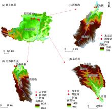
图1
研究流域地理位置示意图"

表1
研究流域主要水文站信息"
| 水文站 | 控制面积/km2 | 年均值 | 数据年限 | ||
|---|---|---|---|---|---|
| 径流/108 m3 | 输沙量/108 t | 降水量/mm | |||
| 图格日格 | 1036 | 0.12 | 0.04 | 276.90 | 1982—2020年 |
| 龙头拐 | 1157 | 0.26 | 0.04 | 279.80 | 1964—2020年 |
| 皇甫 | 3175 | 0.99 | 0.31 | 360.70 | 1964—2020年 |
表2
径流量和输沙量年际变化"
| 年均径流量/104 m3 | 年均输沙量/104 t | ||||||
|---|---|---|---|---|---|---|---|
| 毛不拉孔兑 | 西柳沟 | 皇甫川 | 毛不拉孔兑 | 西柳沟 | 皇甫川 | ||
| 1964—1970年 | 2982.29 | 16922.86 | 401.38 | 5727.43 | |||
| 1971—1980年 | 3527.60 | 16885.00 | 440.66 | 5749.00 | |||
| 1981—1990年 | 2032.89 | 2532.20 | 12523.00 | 1052.18 | 669.60 | 4362.20 | |
| 1991—2000年 | 1905.49 | 3256.60 | 8594.00 | 365.08 | 402.25 | 2506.70 | |
| 2001—2010年 | 708.43 | 2005.09 | 3370.70 | 211.64 | 131.46 | 881.40 | |
| 2011—2020年 | 323.97 | 1457.84 | 2925.90 | 12.29 | 54.23 | 349.83 | |
| 最大值 | 8785.00 | 8562.00 | 43700.00 | 7158.67 | 4761.94 | 15400.00 | |
| 最小值 | 49.01 | 568.40 | 0.00 | 0.03 | 0.01 | 0.00 | |
| 多年平均 | 1222.43 | 2608.41 | 9849.93 | 393.84 | 353.41 | 3133.04 | |
| Cv | 1.35 | 0.72 | 0.92 | 2.99 | 2.01 | 1.16 | |
表3
水沙序列M-K趋势检验"
| 流域 | 序列 | Z值 | 趋势性 |
|---|---|---|---|
| 毛不拉孔兑 | 径流 | -3.24 | Z<0,|Z|>1.96,下降趋势显著 |
| 输沙 | -3.90 | Z<0,|Z|>1.96,下降趋势显著 | |
| 西柳沟 | 径流 | -4.06 | Z<0,|Z|>1.96,下降趋势显著 |
| 输沙 | -3.77 | Z<0,|Z|>1.96,下降趋势显著 | |
| 皇甫川 | 径流 | -5.76 | Z<0,|Z|>1.96,下降趋势显著 |
| 输沙 | -5.77 | Z<0,|Z|>1.96,下降趋势显著 |
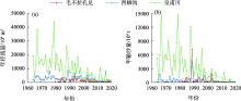
图2
径流量、输沙量历年过程线"

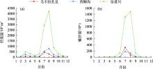
图3
径流输沙年内分配过程线"

表4
径流量、输沙量年内分配"
| 站名 | 径流量/104 m3 | 输沙量/104 t | |||||
|---|---|---|---|---|---|---|---|
| 6—9月 | 7—8月 | Cv | 6—9月 | 7—8月 | Cv | ||
| 毛不拉孔兑 | 86.1 | 78.4 | 5.99 | 99.8 | 97.1 | 9.11 | |
| 西柳沟 | 66.8 | 53.8 | 3.69 | 99.4 | 91.3 | 7.10 | |
| 皇甫川 | 85.0 | 72.7 | 5.41 | 98.7 | 90.1 | 6.87 | |
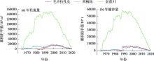
图4
径流量和输沙量累积距平曲线"
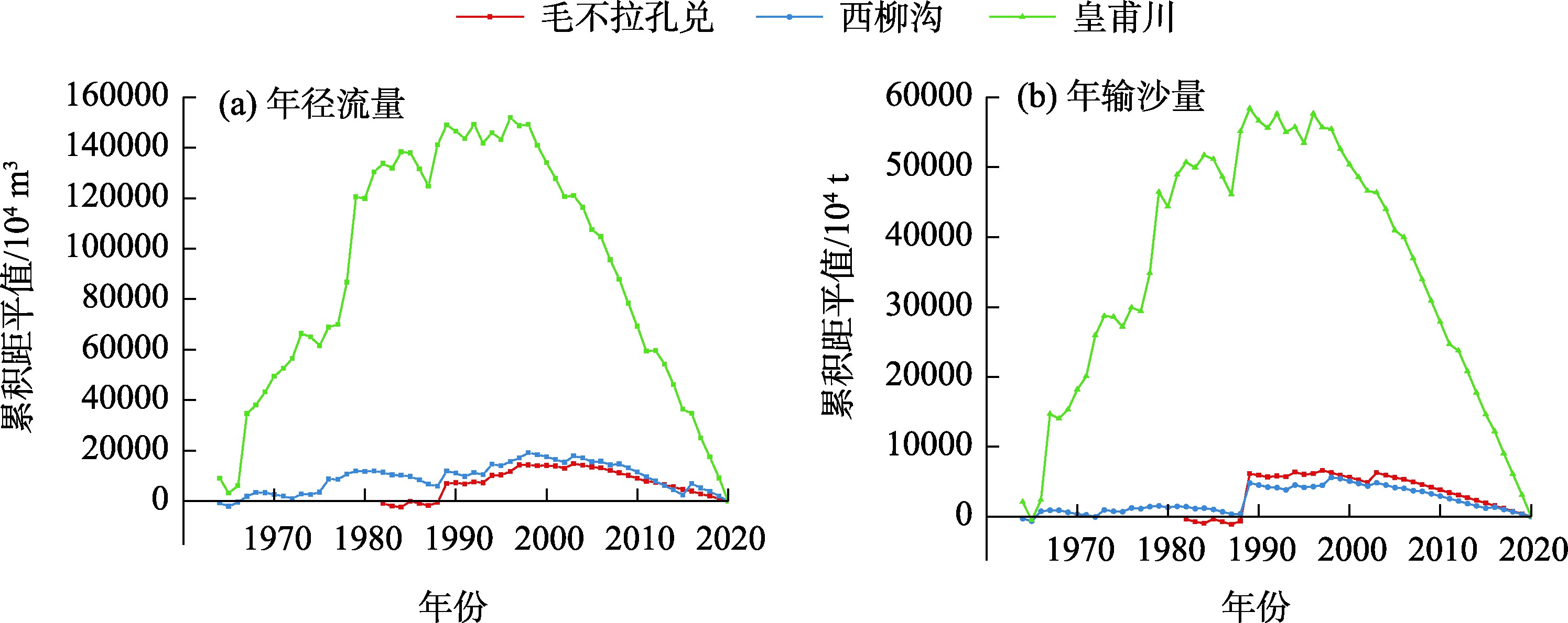
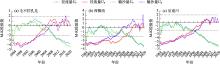
图5
径流量和输沙量M-K突变检验"

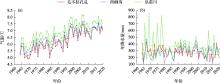
图6
气温、降水历年过程线"

表5
气温、降水M-K趋势检验"
| 流域 | Z值 | 趋势性 | |
|---|---|---|---|
| 气温 | 毛不拉孔兑 | 6.68 | Z>0,|Z|>1.96,增加趋势显著 |
| 西柳沟 | 6.52 | Z>0,|Z|>1.96,增加趋势显著 | |
| 皇甫川 | 6.31 | Z>0,|Z|>1.96,增加趋势显著 | |
| 降水 | 毛不拉孔兑 | -2.37 | Z<0,|Z|>1.96,下降趋势显著 |
| 西柳沟 | 2.09 | Z>0,|Z|>1.96,增加趋势显著 | |
| 皇甫川 | 0.39 | Z>0,|Z|<1.96,增加趋势不显著 |
表6
降水量年际变化"
| 年均降水量/mm | |||
|---|---|---|---|
| 毛不拉孔兑 | 西柳沟 | 皇甫川 | |
| 1964—1970年 | 310.4 | 265.2 | 380.8 |
| 1971—1980年 | 299.1 | 242.1 | 410.9 |
| 1981—1990年 | 276.7 | 247.2 | 312.2 |
| 1991—2000年 | 280.3 | 317.7 | 371.4 |
| 2001—2010年 | 272.2 | 308.1 | 352.1 |
| 2011—2020年 | 233.0 | 294.1 | 337.0 |
| 最大值 | 429.6 | 471.4 | 851.0 |
| 最小值 | 142.4 | 113.0 | 174.2 |
| 多年平均 | 276.9 | 279.8 | 339.5 |
| Cv | 0.3 | 0.3 | 0.4 |
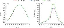
图7
气温、降水年内分配"
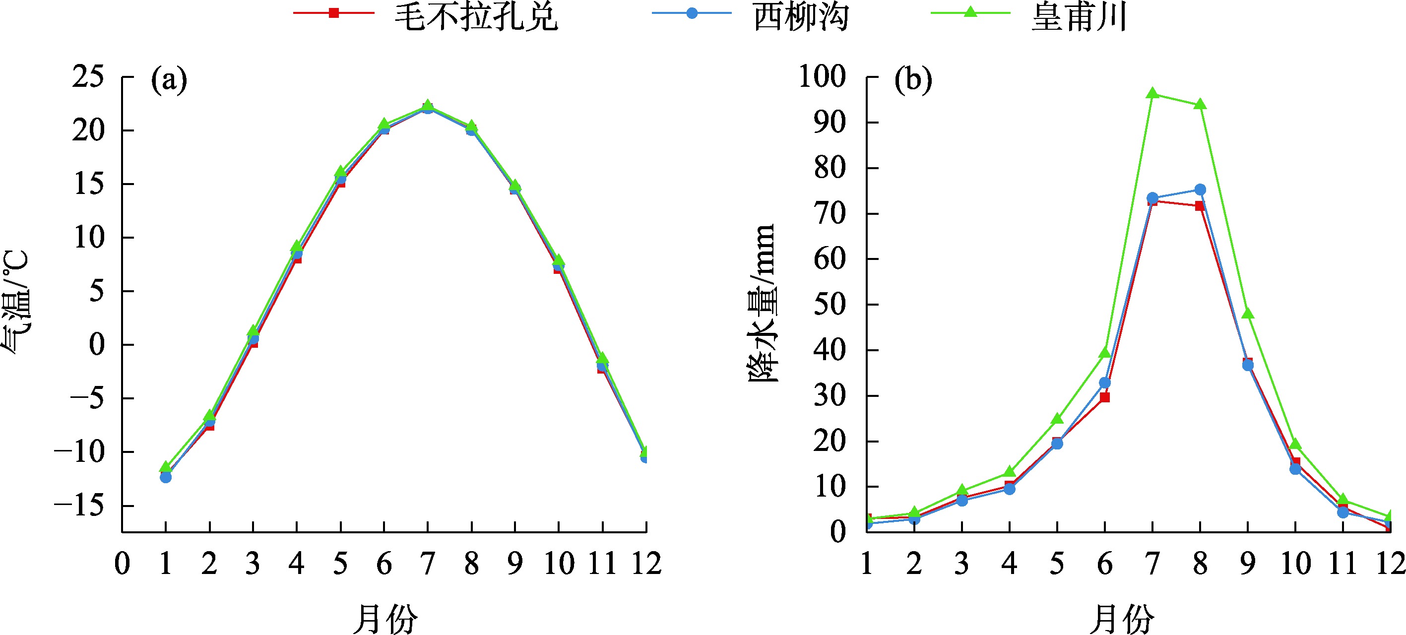
表7
植被覆盖度M-K趋势检验"
| 流域 | Z值 | 趋势性 |
|---|---|---|
| 毛不拉孔兑 | 4.06 | Z>0,|Z|>1.96,增加趋势显著 |
| 西柳沟 | 3.67 | Z>0,|Z|>1.96,增加趋势显著 |
| 皇甫川 | 5.03 | Z>0,|Z|>1.96,增加趋势显著 |
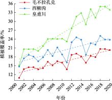
图8
植被覆盖度年际变化"

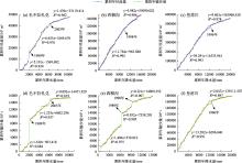
图9
降水-径流、降水-输沙双累积曲线"

表8
降水对流域径流量的影响"
| 流域 | 时段 | 实测值/108 m3 | 计算值/108 m3 | 实测径流量变化 | 降水影响 | 非降水影响 | |||||
|---|---|---|---|---|---|---|---|---|---|---|---|
| 变化量/108 m3 | 占比/% | 变化量/108 m3 | 占比/% | 变化量/108 m3 | 占比/% | ||||||
| 毛不拉孔兑 | MP1 | 0.114 | 0.114 | ||||||||
| MP2 | 0.219 | 0.148 | 0.105 | 92.1 | 0.034 | 32.4 | 0.071 | 67.6 | |||
| MP3 | 0.050 | 0.126 | -0.064 | -56.1 | 0.012 | -18.8 | -0.076 | 118.8 | |||
| 西柳沟 | XP1 | 0.311 | 0.311 | ||||||||
| XP2 | 0.187 | 0.352 | -0.124 | -39.9 | 0.041 | -33.1 | -0.165 | 133.1 | |||
| 皇甫川 | HP1 | 1.432 | 1.432 | ||||||||
| HP2 | 0.412 | 1.347 | -1.020 | -71.2 | -0.085 | 8.3 | -0.935 | 91.7 | |||
表9
降水对流域输沙量的影响"
| 流域 | 时段 | 实测值/108 t | 计算值/108 t | 实测输沙量变化 | 降水影响 | 非降水影响 | |||||
|---|---|---|---|---|---|---|---|---|---|---|---|
| 变化量/108 t | 占比/% | 变化量/108 t | 占比/% | 变化量/108 t | 占比/% | ||||||
| 毛不拉孔兑 | MP1 | 0.031 | 0.031 | ||||||||
| MP2 | 0.079 | 0.039 | 0.048 | 154.8 | 0.008 | 16.7 | 0.04 | 83.3 | |||
| MP3 | 0.012 | 0.033 | -0.019 | -61.3 | 0.002 | -10.5 | -0.021 | 110.5 | |||
| 西柳沟 | XP3 | 0.036 | 0.036 | ||||||||
| XP4 | 0.080 | 0.048 | 0.044 | 122.2 | 0.012 | 27.3 | 0.032 | 72.7 | |||
| XP5 | 0.015 | 0.044 | -0.021 | -58.3 | 0.008 | -38.1 | -0.029 | 138.1 | |||
| 皇甫川 | HP1 | 0.480 | 0.480 | ||||||||
| HP2 | 0.099 | 0.462 | -0.381 | -79.4 | -0.018 | 4.7 | -0.363 | 95.3 | |||
| [1] | 夏军, 彭少明, 王超, 等. 气候变化对黄河水资源的影响及其适应性管理[J]. 人民黄河, 2014, 36(10): 1-4, 15. |
| [ Xia Jun, Peng Shaoming, Wang Chao, et al. Impact of climate change on water resources and adaptive management in the Yellow River Basin[J]. Yellow River, 2014, 36(10): 1-4, 15. ] | |
| [2] | 姚文艺, 冉大川, 陈江南. 黄河流域近期水沙变化及其趋势预测[J]. 水科学进展, 2013, 24(5): 607-616. |
| [ Yao Wenyi, Ran Dachuan, Chen Jiangnan. Recent changes in runoff and sediment regimes and future projections in the Yellow River Basin[J]. Advances in Water Science, 2013, 24(5): 607-616. ] | |
| [3] |
李森, 杨宗英, 赵鸿雁, 等. 1975—2020年黄河“几字弯”沙漠化时空变化[J]. 中国沙漠, 2024, 44(5): 13-22.
doi: 10.7522/j.issn.1000-694X.2024.00018 |
|
[ Li Sen, Yang Zongying, Zhao Hongyan, et al. Spatio-temporal changes of aeolian desertification in the Jiziwan of the Yellow River from 1975 to 2020[J]. Journal of Desert Research, 2024, 44(5): 13-22. ]
doi: 10.7522/j.issn.1000-694X.2024.00018 |
|
| [4] | 安树伟, 张双悦. 黄河“几”字弯区域高质量发展研究[J]. 山西大学学报(哲学社会科学版), 2021, 44(2): 134-144. |
| [ An Shuwei, Zhang Shuangyue. On the high-quality development of the bend area of the Yellow River[J]. Journal of Shanxi University (Philosophy and Social Science Edition), 2021, 44(2): 134-144. ] | |
| [5] | 赵宏胜, 党晓宏, 蒙仲举, 等. 黄河流域西柳沟孔兑中游输沙势及风沙入黄贡献量研究[J/OL]. 中国环境科学, 1-15[2025-10-24]. https://doi.org/10.19674/j.cnki.issn1000-6923.20240018.002. |
| [ Zhao Hongsheng, Dang Xiaohong, Meng Zhongju, et al. Study on sediment transport potential and contribution of wind-blown sand into Yellow River in Xiliugou hole and middle reaches of Yellow River Basin[J]. China Environmental Science, 1-15[2025-10-24]. https://doi.org/10.19674/j.cnki.issn1000-6923.20240018.002. ] | |
| [6] | 赵江涛, 赵广举, 穆兴民, 等. 罕台川流域水沙变化及其归因[J]. 水土保持研究, 2023, 30(5): 169-174. |
| [ Zhao Jiangtao, Zhao Gua-ngju, Mu Xingmin, et al. Runoff and sediment load variation and driving factors in the Hantaichuan Basin[J]. Research of Soil and Water Conservation, 2023, 30(5): 169-174. ] | |
| [7] | 兰泽凡, 耿韧, 赵广举, 等. 窟野河流域水沙变化及其驱动因素[J]. 水土保持研究, 2024, 31(4): 95-104. |
| [ Lan Zefan, Geng Ren, Zhao Guangju, et al. Runoff and sediment load variation and driving factors in the Kuye River Basin[J]. Research of Soil and Water Conservation, 2024, 31(4): 95-104. ] | |
| [8] | 冉大川, 张栋, 焦鹏, 等. 西柳沟流域近期水沙变化归因分析[J]. 干旱区资源与环境, 2016, 30(5): 143-149. |
| [ Ran Dachuan, Zhang Dong, Jiao Peng, et al. Analysis on the attribution of water and sediment changes in Xiliugou Basin[J]. Journal of Arid Land Resources and Environment, 2016, 30(5): 143-149. ] | |
| [9] |
刘任涛, 程静. 黄河“几字弯”的地理界定及主要生态问题[J]. 应用生态学报, 2025, 36(2): 383-394.
doi: 10.13287/j.1001-9332.202502.028 |
|
[ Liu Rentao, Cheng Jing. Geographical boundary line of the Yellow River’s ‘Ji Zi Bend’ and its main ecological issues[J]. Chinese Journal of Applied Ecology, 2025, 36(2): 383-394. ]
doi: 10.13287/j.1001-9332.202502.028 |
|
| [10] | 许林军, 杨亚娟, 朱莉莉, 等. 毛不拉孔兑水土流失特征与防治布局[J]. 水土保持应用技术, 2011(6): 32-34. |
| [ Xu Linjun, Yang Yajuan, Zhu Lili, et al. Soil erosion characteristics and prevention layout of Maobula Kongdui[J]. Technology of Soil and Water Conservation, 2011(6): 32-34. ] | |
| [11] | 张怡捷, 康宾, 张秀梅, 等. 内蒙古十大孔兑西柳沟流域土壤侵蚀及水土保持措施调查[J]. 水土保持通报, 2023, 43(6): 391-401. |
| [ Zhang Yijie, Kang Bin, Zhang Xiumei, et al. Soil erosion and soil and water conservation measures at Xiliugou watershed in Ten Tributaries Area in Inner Mongolia[J]. Bulletin of Soil and Water Conservation, 2023, 43(6): 391-401. ] | |
| [12] | 冉大川, 高健翎, 赵安成, 等. 皇甫川流域水沙特性分析及其治理对策[J]. 水利学报, 2003(2): 122-128. |
| [ Ran Dachuan, Gao Jianling, Zhao Ancheng, et al. Analysis on runoff and sediment characteristics and harnessing measure in Huangfuchuan river watershed[J]. Journal of Hydraulic Engineering, 2003(2): 122-128. ] | |
| [13] |
刘强, 尉飞鸿, 常康飞, 等. 皇甫川流域水沙变化特征及其影响因素[J]. 干旱区研究, 2021, 38(6): 1506-1513.
doi: 10.13866/j.azr.2021.06.02 |
|
[ Liu Qiang, Yu Feihong, Chang Kangfei, et al. Characteristics of water and sediment variation in the Huangfuchuan basin and its influencing factors[J]. Arid Zone Research, 2021, 38(6): 1506-1513. ]
doi: 10.13866/j.azr.2021.06.02 |
|
| [14] | 彭守璋. 中国1 km分辨率逐月降水量数据集(1901-2024)[DB/OL]. 国家青藏高原数据中心, 2025-07-02. |
| [ Peng Shouzhang. 1-km monthly precipitation dataset for China (1901-2024)[DB/OL]. National Tibetan Plateau/Third Pole Environment Data Center, 2025-07-02. ] | |
| [15] | 高吉喜, 史园莉, 张宏伟, 等. 中国区域250米植被覆盖度数据集(2000-2024)[DB/OL]. 国家青藏高原数据中心, 2025-07-24. |
| [ Gao Jixi, Shi Yuanli, Zhang Hongwei, et al. China regional 250 m fractional vegetation cover data set (2000-2024)[DB/OL]. National Tibetan Plateau/Third Pole Environment Data Center, 2025-07-24. ] | |
| [16] | 韩双宝, 王赛, 赵敏敏, 等. 北洛河流域生态环境变迁及对水资源和水沙关系的影响[J]. 水文地质工程地质, 2023, 50(6): 14-24. |
| [ Han Shuangbao, Wang Sai, Zhao Minmin, et al. Ecological environmental changes and its impact on water resources andwater-sediments relationship in Beiluo River Basin[J]. Hydrogeology & Engineering Geology, 2023, 50(6): 14-24. ] | |
| [17] | 曲绅豪, 周文婷, 张翔, 等. 黄河中游典型流域近60年水沙变化趋势及影响因素[J]. 水土保持学报, 2023, 37(3): 35-42. |
| [ Qu Shenhao, Zhou Wenting, Zhang Xiang, et al. Variation trend and influencing factors of water and sediment in the middle reaches of the Yellow River in recent 60 years[J]. Journal of Soil and Water Conservation, 2023, 37(3): 35-42. ] | |
| [18] |
王随继, 闫云霞, 颜明, 等. 皇甫川流域降水和人类活动对径流量变化的贡献率分析——累积量斜率变化率比较方法的提出及应用[J]. 地理学报, 2012, 67(3): 388-397.
doi: 10.11821/xb201203010 |
|
[ Wang Suiji, Yan Yunxia, Yan Ming, et al. Contributions of precipitation and human activities to the runoff change of the Huangfuchuan Drainage Basin: Application of comparative method of the mlope changing ratio of cumulative quantity[J]. Acta Geographica Sinica, 2012, 67(3): 388-397. ]
doi: 10.11821/xb201203010 |
|
| [19] | 刁文博. 变化环境对无定河流域水沙的影响[D]. 杨凌: 西北农林科技大学, 2013. |
| [ Diao Wenbo. Influences of Runoff and Sediment of Wuding River Waterdshed by the Chanjing Environment[D]. Yangling: Northwest A & F University, 2013. ] | |
| [20] | 姚海芳, 师长兴, 顾畛逵. 气候变化和人类活动对黄河上游十大孔兑水沙过程的影响[J]. 干旱区地理, 2018, 41(3): 472-479. |
| [ Yao Haifang, Shi Changxing, Gu Zhenkui. Impacts of climate change and human activities on water discharge and sediment load of ten tributaries (the Ten Kongduis) of the upper Yellow River[J]. Arid Land Geography, 2018, 41(3): 472-479. ] | |
| [21] | 吴志勇, 侍恒, 何海, 等. 岔巴沟流域植被变化特征及其对水沙的影响[J]. 水资源保护, 2020, 36(1): 31-37. |
| [ Wu Zhiyong, Shi Heng, He Hai, et al. Characteristics of vegetation change and impact on runoff and sediment in Chabagou Watershed[J]. Water Resources Protection, 2020, 36(1): 31-37. ] | |
| [22] | 刘通, 黄河清, 邵明安, 等. 气候变化与人类活动对鄂尔多斯地区西柳沟流域入黄水沙过程的影响[J]. 水土保持学报, 2015, 29(2): 17-22. |
| [ Liu Tong, Huang Heqing, Shao Ming’an, et al. Impacts of climate change and human activity on process of water and sediment load along Yellow River in Erdos[J]. Journal of Soil and Water Conservation, 2015, 29(2): 17-22. ] | |
| [23] | 王瑞, 奇晓霞. 毛不拉孔兑水土流失防治对策[J]. 内蒙古水利, 2023(5): 68-69. |
| [ Wang Rui, Ji Xiaoxia. Countermeasures of soil and water loss control in Maobulakongdui[J]. Inner Mongolia Water Resources, 2023(5): 68-69. ] | |
| [24] | 方学敏, 万兆惠, 匡尚富. 黄河中游淤地坝拦沙机理及作用[J]. 水利学报, 1998(10): 50-54. |
| [ Fang Xuemin, Wan Zhaohui, Kuang Shangfu. Mechanism and effect of silt arrest dams for sediment reduction in the middle Yellow River Basin[J]. Journal of Hydraulic Engineering, 1998(10): 50-54. ] | |
| [25] | 万晓丹, 周晓岚, 赵丽霞, 等. 皇甫川流域水沙变化趋势及影响因素分析[J]. 中国农村水利水电, 2019(12): 90-93. |
| [ Wan Xiaodan, Zhou Xiaolan, Zhao Lixia, et al. An analysis of the trend of water and sediment change and its influencing factors in Huangfuchuan River Basin[J]. China Rural Water and Hydropower, 2019(12): 90-93. ] | |
| [26] | 赵广举, 穆兴民, 温仲明, 等. 皇甫川流域降水和人类活动对水沙变化的定量分析[J]. 中国水土保持科学, 2013, 11(4): 1-8. |
| [ Zhao Guangju, Mu Xingmin, Wen Zhongming, et al. Impacts of precipitation and human activities on streamflow and sediment load in the Huangfuchuan Watershed[J]. Science of Soil and Water Conservation, 2013, 11(4): 1-8. ] | |
| [27] | 王丽云, 马振刚, 高云飞, 等. 近10 a来十大孔兑现状淤地坝拦沙作用分析[J]. 人民黄河, 2018, 40(9): 89-92. |
| [ Wang Liyun, Ma Zhengang, Gao Yunfei, et al. Quantity of sediment intercepted by warping dams in the Ten Tributaries over the past ten years[J]. Yellow River, 2018, 40(9): 89-92. ] |
| [1] | 商淑静, 刘丹辉, 周轶昕, 吴家驹, 陆婷, 李文军. 气候变化背景下软紫草在中国的潜在适生区预测[J]. 干旱区研究, 2025, 42(9): 1628-1639. |
| [2] | 蒋安尧, 陈睿山, 郑利林, 郭晓娜, 孙南沙, 李因帅. “三北”工程区极端降水时空演变特征与影响[J]. 干旱区研究, 2025, 42(8): 1357-1368. |
| [3] | 严应存, 孙树娇, 余迪, 高贵生. 气候变化对柴达木盆地植被绿度的影响及趋势预估[J]. 干旱区研究, 2025, 42(7): 1257-1268. |
| [4] | 邵俊杰, 陶通炼, 李志忠. 古尔班通古特沙漠南缘沉积物粒度和微量元素记录晚全新世气候变化[J]. 干旱区研究, 2025, 42(5): 788-799. |
| [5] | 罗磊, 李曦光, 李萧婷, 王磊, 王蕾. 气候变化下沙棘在新疆潜在分布格局的变化[J]. 干旱区研究, 2025, 42(3): 511-522. |
| [6] | 赵艳芬, 王春成, 潘伯荣. 气候变化下脓疮草在中国的适宜分布区预测[J]. 干旱区研究, 2025, 42(10): 1851-1859. |
| [7] | 岳胜如, 胡雪菲, 侯晓华, 孟福军. 基于CMIP6模式的塔里木河流域棉花生产评估[J]. 干旱区研究, 2025, 42(10): 1925-1938. |
| [8] | 邹彬, 邹珊, 杨余辉. 1990—2023年新疆地表水体面积动态变化及其驱动因素[J]. 干旱区研究, 2025, 42(1): 40-50. |
| [9] | 吕壮壮, 乔庆庆, 董孙艺, 汪冬. 中中新世气候适宜期全球变暖背景下亚洲内陆干旱区古气候演化特征及驱动机制[J]. 干旱区研究, 2024, 41(8): 1309-1322. |
| [10] | 吴思源, 郝利娜. 2001—2021年黄河流域植被覆盖变化及其驱动因素[J]. 干旱区研究, 2024, 41(8): 1373-1384. |
| [11] | 周杰, 王旭虎, 杜维波, 周晓雷, 杨洁, 张晓玮. 气候变化背景下的天山云杉潜在分布区预测[J]. 干旱区研究, 2024, 41(7): 1167-1176. |
| [12] | 杨荣钦, 肖玉磊, 池苗苗, 穆振侠. 近20 a塔里木河流域人类活动及景观生态风险时空变化[J]. 干旱区研究, 2024, 41(6): 1010-1020. |
| [13] | 梁双河, 牛最荣, 贾玲. 祖厉河干流近65 a径流变化及归因分析[J]. 干旱区研究, 2024, 41(6): 928-939. |
| [14] | 唐可欣, 郭建斌, 何亮, 陈林, 万龙. 中国旱区GPP时空演变特征及影响因素研究[J]. 干旱区研究, 2024, 41(6): 964-973. |
| [15] | 裴志林, 曹晓娟, 王冬, 李迪, 王鑫, 白艾原. 内蒙古植被覆盖时空变化特征及其对人类活动的响应[J]. 干旱区研究, 2024, 41(4): 629-638. |
|
||