干旱区研究 ›› 2025, Vol. 42 ›› Issue (8): 1501-1513.doi: 10.13866/j.azr.2025.08.13 cstr: 32277.14.AZR.20250813
关毅珩( ), 孟梅(), 杨松晓, 李大强
收稿日期:2025-03-07
修回日期:2025-05-21
出版日期:2025-08-15
发布日期:2025-11-24
通讯作者:
孟梅. E-mail: mengmeihh@163.com作者简介:关毅珩(2001-),男,硕士研究生,主要从事土地资源管理等方面的研究. E-mail: guanyihengouo@163.com
基金资助:
GUAN Yiheng(), MENG Mei(), YANG Songxiao, LI Daqiang
Received:2025-03-07
Revised:2025-05-21
Published:2025-08-15
Online:2025-11-24
摘要: 探究生态环境基底脆弱的干旱区土地利用强度与碳排放的协同关系,对促进区域土地资源优化配置和实现“双碳”目标具有重要的现实意义。本研究基于2000年、2005年、2010年、2015年和2020年的土地利用和能源消耗数据,采用土地利用碳排放核算模型、协调度模型、未来土地利用模拟(Future Land Use Simulation,FLUS)模型和灰色预测模型,探究新疆和海拔1500 m以下区域的土地利用强度和碳排放的时空分异规律及协调发展水平,并模拟2030年4种情景下的演变趋势。结果表明:(1) 2000—2020年新疆土地利用强度指数增加3.2,新疆海拔1500 m以下区域土地利用强度指数增加4.5,增长速率高于全疆增长速率。(2) 2000—2020年新疆土地利用碳排放增加1.70×10⁸ t,新疆海拔1500 m以下区域贡献率超95%,且碳排放高值区对低值区的侵蚀现象显著。(3) 2000—2020年新疆海拔1500 m以下区域协调系数始终高于全疆水平,其本质为“高开发-高排放”的粗放平衡。(4) 相关结果显示2030年在生态保护情景(Ecological Protection Scenario,EPS)下,可以通过生态用地扩容来实现开发与减排平衡;而在战略发展情景(Strategic Development Scenario,SDS)下,碳排放增量最大,反映出经济建设仍依赖能源消耗。研究结果反映新疆需进一步统筹经济建设与生态保护,才能有效实现可持续发展道路。
关毅珩, 孟梅, 杨松晓, 李大强. 新疆土地利用强度与碳排放协调发展及多情景模拟[J]. 干旱区研究, 2025, 42(8): 1501-1513.
GUAN Yiheng, MENG Mei, YANG Songxiao, LI Daqiang. Coordinated development and multi-scenario simulation of land use intensity and carbon emissions in Xinjiang[J]. Arid Zone Research, 2025, 42(8): 1501-1513.
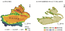
图1
研究区概况和土地利用类型示意图 注:底图采用国家地理信息公共服务平台标准地图制作,审图号为GS(2024)0650号,对底图边界无修改。下同。"

表1
数据来源与处理"
| 数据类型 | 数据名称 | 数据来源 | 空间分辨率 |
|---|---|---|---|
| 土地利用数据 | 2000—2020年土地利用遥感数据 | 中国科学院资源环境科学数据平台( | 30 m×30 m |
| 能源消耗数据 | 2000—2020年新疆能源消耗量 | 《中国能源统计年鉴》《新疆统计年鉴》 | - |
| 驱动因子数据 | 高程 | 地理空间数据云( 基于ArcGIS 10.8对高程数据空间分析得出 | 30 m×30 m |
| 坡度 | |||
| 坡向 | |||
| 年均气温 | 国家青藏高原科学数据中心( | 1000 m×1000 m | |
| 年降水量 | |||
| 到国道距离 | 全国地理信息资源目录服务系统( 基于ArcGIS 10.8欧氏距离分析得出 | 1000 m×1000 m | |
| 到省道距离 | |||
| 到高速距离 | |||
| 到铁路距离 | |||
| 到水系距离 | |||
| 夜间灯光 | 中国科学院资源环境科学数据平台( | 1000 m×1000 m |
表2
能源标准煤系数以及碳排放系数"
| 能源类型 | 折标准煤系数 | 碳排放系数/(t·t-1) |
|---|---|---|
| 原煤 | 0.7143 kgce·t-1 | 0.7559 |
| 焦炭 | 0.9714 kgce·t-1 | 0.8550 |
| 原油 | 1.4286 kgce·t-1 | 0.5857 |
| 汽油 | 1.4714 kgce·t-1 | 0.5538 |
| 煤油 | 1.4714 kgce·t-1 | 0.5714 |
| 柴油 | 1.4571 kgce·t-1 | 0.5921 |
| 燃料油 | 1.4286 kgce·t-1 | 0.6185 |
| 天然气 | 1.3300 kgce·m-3 | 0.4483 |
| 电力 | 0.1229 kgce·kWh-1 | 0.7330 |
表3
协调类型级别划定"
| 协调度区间 | 协调度类别 | 协调度类型 | 解释说明 |
|---|---|---|---|
| 0.0~0.5 | 严重失调 | 失调衰退区 | 土地利用强度与碳排放 的增长为失调衰退状态 |
| 0.5~0.6 | 轻度失调 | ||
| 0.6~0.7 | 濒临失调 | 磨合协调区 | 土地利用强度与碳排放 的增长处于调和状态 |
| 0.7~0.8 | 勉强协调 | ||
| 0.8~0.9 | 基本协调 | 协调发展区 | 土地利用强度与碳排放 协调增长且速度较快 |
| 0.9~1.0 | 良好协调 |
表4
2030年各情景下的用地转移成本矩阵"
| 自然发展情景(NDS) | 战略发展情景(SDS) | 粮食安全情景(FSS) | 生态保护情景(EPS) | ||||||||||||||||||||||||
|---|---|---|---|---|---|---|---|---|---|---|---|---|---|---|---|---|---|---|---|---|---|---|---|---|---|---|---|
| A | B | C | D | E | F | A | B | C | D | E | F | A | B | C | D | E | F | A | B | C | D | E | F | ||||
| A | 1 | 1 | 1 | 1 | 1 | 0 | 1 | 0 | 0 | 0 | 0 | 0 | 1 | 0 | 0 | 0 | 0 | 0 | 1 | 1 | 1 | 1 | 1 | 1 | |||
| B | 1 | 1 | 1 | 0 | 1 | 0 | 1 | 1 | 0 | 0 | 1 | 0 | 1 | 1 | 0 | 0 | 0 | 0 | 0 | 1 | 0 | 0 | 0 | 0 | |||
| C | 1 | 1 | 1 | 0 | 1 | 1 | 1 | 0 | 1 | 0 | 1 | 0 | 1 | 0 | 1 | 0 | 0 | 0 | 0 | 1 | 1 | 0 | 0 | 0 | |||
| D | 0 | 0 | 1 | 1 | 1 | 1 | 0 | 0 | 0 | 1 | 1 | 0 | 1 | 0 | 0 | 1 | 0 | 0 | 0 | 0 | 0 | 1 | 0 | 0 | |||
| E | 1 | 1 | 1 | 1 | 1 | 0 | 0 | 0 | 0 | 0 | 1 | 0 | 1 | 0 | 0 | 0 | 1 | 0 | 0 | 0 | 0 | 0 | 1 | 1 | |||
| F | 1 | 1 | 0 | 1 | 1 | 1 | 1 | 1 | 1 | 1 | 1 | 1 | 1 | 1 | 1 | 1 | 1 | 1 | 1 | 1 | 1 | 1 | 1 | 1 | |||
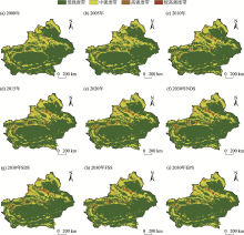
图2
2000—2020年新疆土地利用强度以及2030年多情景模拟 注:NDS为自然发展情景,SDS为战略发展情景,FSS为粮食安全情景,EPS为生态保护情景。下同。"

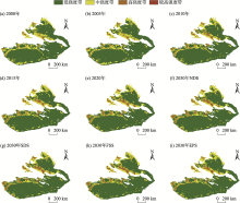
图3
2000—2020年新疆海拔1500 m以下区域土地利用强度以及2030年多情景模拟"


图4
2000—2020年新疆土地利用碳排放以及2030年多情景模拟"

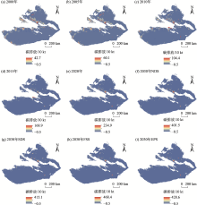
图5
2000—2020年新疆海拔1500 m以下区域土地利用碳排放以及2030年多情景模拟"

表5
新疆土地利用强度与碳排放协调发展变化"
| 时段及情景模拟时段 | 失调衰退区占比/% | 磨合协调区占比/% | 协调发展区占比/% | 协调系数 |
|---|---|---|---|---|
| 2000—2005年 | 3 | 57 | 40 | 0.700 |
| 2005—2010年 | 8 | 43 | 49 | 0.715 |
| 2010—2015年 | 5 | 62 | 33 | 0.721 |
| 2015—2020年 | 6 | 79 | 15 | 0.732 |
| 2000—2020年 | 6 | 53 | 41 | 0.724 |
| 2020—2030年NDS | 5 | 70 | 25 | 0.741 |
| 2020—2030年SDS | 7 | 73 | 20 | 0.748 |
| 2020—2030年FSS | 5 | 71 | 24 | 0.745 |
| 2020—2030年EPS | 9 | 69 | 22 | 0.739 |
表6
新疆海拔1500 m以下土地利用强度与碳排放协调发展变化"
| 时期 | 失调衰退区占比/% | 磨合协调区占比/% | 协调发展区占比/% | 协调系数 |
|---|---|---|---|---|
| 2000—2005年 | 2 | 64 | 34 | 0.720 |
| 2005—2010年 | 3 | 78% | 19 | 0.727 |
| 2010—2015年 | 3 | 69 | 28 | 0.736 |
| 2015—2020年 | 4 | 88 | 8 | 0.741 |
| 2000—2020年 | 4 | 66 | 30 | 0.725 |
| 2020—2030年NDS | 3 | 79 | 18 | 0.749 |
| 2020—2030年SDS | 3 | 83 | 14 | 0.755 |
| 2020—2030年FSS | 5 | 81 | 14 | 0.752 |
| 2020—2030年EPS | 9 | 76 | 15 | 0.742 |
| [1] |
Woo T H. Climate change analysis in energy-mix with non-carbon emission energy incorporated with pandemic society[J]. Environment, Development and Sustainability, 2022, 25(10): 1-11.
doi: 10.1007/s10668-021-01998-6 |
| [2] |
Diao J, Liu J, Zhu Z, et al. Substantially greater carbon emissions estimated based on annual land-use transition data[J]. Remote Sensing, 2020, 12(7): 1126.
doi: 10.3390/rs12071126 |
| [3] |
李璐, 董捷, 徐磊, 等. 功能区土地利用碳收支空间分异及碳补偿分区——以武汉城市圈为例[J]. 自然资源学报, 2019, 34(5): 1003-1015.
doi: 10.31497/zrzyxb.20190508 |
|
[Li Lu, Dong Jie, Xu Lei, et al. Spatial variation of land use carbon budget and carbon compensation zoning in functional areas: A case study of Wuhan urban agglomeration[J]. Journal of Natural Resources, 2019, 34(5): 1003-1015.]
doi: 10.31497/zrzyxb.20190508 |
|
| [4] |
Ou J, Liu X, Xia L, et al. Quantifying the relationship between urban forms and carbon emissions using panel data analysis[J]. Landscape Ecology, 2013, 28(10): 1889-1907.
doi: 10.1007/s10980-013-9943-4 |
| [5] |
王微, 杨淑婷, 海云瑞. 宁夏土地利用碳排放时空演变及影响因素[J]. 干旱区研究, 2025, 42(3): 545-555.
doi: 10.13866/j.azr.2025.03.14 |
| [Wang Wei, Yang Shuting, Hai Yunrui. The spatial temporal evolution and influencing factors of carbon emissions from land use in Ningxia[J]. Arid Zone Research, 2025, 42(3): 545-555.] | |
| [6] |
Wang L, Pei J, Geng J, et al. Tracking the spatial-temporal evolution of carbon emissions in China from 1999 to 2015: A land use perspective[J]. Sustainability, 2019, 11(17): 4531.
doi: 10.3390/su11174531 |
| [7] | 张余, 姜博, 赵映慧, 等. 东北三省土地利用碳排放时空格局及影响因素研究[J]. 地域研究与开发, 2022, 41(4): 150-156. |
| [Zhang Yu, Jiang Bo, Zhao Yinghui, et al. Temporal and spatial pattern changes and influencing factors of land use carbon emissions in the three provinces of Northest China[J]. Areal Research and Development, 2022, 41(4): 150-156.] | |
| [8] |
Hong C, Jennifer A B, Julia P R, et al. Global and regional drivers of land-use emissions in 1961-2017[J]. Nature, 2021, 589(7843): 554-561.
doi: 10.1038/s41586-020-03138-y |
| [9] | 罗义, 陈顺, 刘伟强, 等. 河北省土地利用碳排放时空演变分析及预测研究[J]. 环境工程学报, 2024, 18(11): 3360-3373. |
| [Luo Yi, Chen Shun, Liu Weiqiang, et al. Analysis and prediction on the spatial temporal evolution of carbon emissions from land use in Hebei Province[J]. Chinese Journal of Environmental Engineering, 2024, 18(11): 3360-3373.] | |
| [10] |
杨坤, 胡馨, 石越. 基于RS和GIS的土地利用变化碳排放现状及预测分析[J]. 长江科学院院报, 2016, 33(7): 137-141.
doi: 10.11988/ckyyb.20150229 |
| [Yang Kun, Hu Xin, Shi Yue. Current situation and prediction analysis of land use changes in carbon emissions based on RS and GIS[J]. Journal of Changjiang River Scientific Research Institute, 2016, 33(7): 137-141.] | |
| [11] |
Xu Q Y, Li K Q. Land use carbon emission estimation and simulation of carbon-neutral scenarios based on system dynamics in coastal city: A case study of Nantong, China[J]. Land, 2024, 13(7): 1083.
doi: 10.3390/land13071083 |
| [12] | 金都, 董文明, 刘新平. 新疆塔里木河流域土地利用变化对碳排放的影响: 考虑能源消耗中介效应和绿色科技调节效应[J]. 环境工程学报, 2023, 17(11): 3754-3762. |
| [Jin du, Dong Wenming, Liu Xinping. Impacts of land use change on carbon emissions in the Tarim River Basin of Xinjiang: Considering the mediating effect of energy consumption and the regulatory effect of green technology[J]. Chinese Journal of Environmental Engineering, 2023, 17(11): 3754-3762.] | |
| [13] |
谭洁, 刘琴, 唐晓佩, 等. 基于LMDI模型的土地利用碳排放时空差异及影响因素研究——以洞庭湖区为例[J]. 地域研究与开发, 2024, 43(1): 160-166.
doi: 10.3969/j.issn.10032363.2024.01.024 |
|
[Tan Jie, Liu Qin, Tang Xiaopei, et al. Spatial and temporal evolution of carbon emissions from land use and its influencing factors based on LMDI model: A case study of the Dongting Lake area[J]. Areal Research and Development, 2024, 43(1): 160-166.]
doi: 10.3969/j.issn.10032363.2024.01.024 |
|
| [14] | 汪晗, 吴静兰, 张安录, 等. 土地利用强度碳排放效应分析——以广西南宁为例[J]. 生态经济, 2016, 32(9): 42-46, 99. |
| [Wang Han, Wu Jinglan, Zhang Anlu, et al. Analysis of the effects of land use intensity on carbon emissions: A case study of Nanning City, Guangxi Zhuang Autonomous Region[J]. Ecological Economy, 2016, 32(9): 42-46, 99.] | |
| [15] | 孟庆香, 刘祺, 李保路, 等. 2000—2020年河南省土地利用强度与碳排放脱钩关系[J]. 水土保持通报, 2023, 43(3): 421-429. |
| [Meng Qingxiang, Liu Qi, Li Baolu, et al. Decoupling relationship between land use intensity and carbon emissions in Henan Province during 2000-2020[J]. Bulletin of Soil and Water Conservation, 2023, 43(3): 421-429.] | |
| [16] | 张俊峰, 张安录, 董捷. 土地集约利用与土地利用碳排放的关系研究——以武汉城市圈为例[J]. 农业现代化研究, 2013, 34(6): 717-721. |
| [Zhang Junfeng, Zhang Anlu, Dong Jie. Study on relationship of intensive land use and carbon emission: A case study of Wuhan urban agglomeration[J]. Research of Agricultural Modernization, 2013, 34(6): 717-721.] | |
| [17] | 詹宏娟, 陈德超, 郎峥, 等. 苏州市土地利用强度与碳排放量脱钩空间效应分析[J/OL]. 环境工程, [2025-04-12]. http://kns.cnki.net/kcms/detail/11.2097.X.20250408.1151.002.html.] |
| [Zhan Hongjuan, Chen Dechao, Lang Zheng, et al. Spatial effects analysis of decoupling between land use intensity and carbon emissions in Suzhou City[J/OL]. Environmental Engineering, [2025-04-12]. http://kns.cnki.net/kcms/detail/11.2097.X.20250408.1151.002.html.] | |
| [18] | 冯新惠, 李艳, 余迩, 等. 长三角城市群碳排放绩效与土地利用强度时空格局及协调发展特征[J]. 农业工程学报, 2023, 39(3): 208-218. |
| [Feng Xinhui, Li Yan, Yu Er, et al. Spatiotemporal pattern and coordinating development characteristics of carbon emission performance and land use intensity in the Yangtze River Delta urban agglomeration[J]. Transactions of the Chinese Society of Agricultural Engineering, 2023, 39(3): 208-218.] | |
| [19] | 叶芸, 於冉, 万年顺, 等. 长江经济带产业-碳排放-土地协同发展研究[J]. 水土保持通报, 2022, 42(5): 312-320. |
| [Ye Yun, Yu Ran, Wan Nianshun, et al. Research on coordinated development of production development carbon emission and land use in Yangtze River Economic Belt[J]. Bulletin of Soil and Water Conservation, 2022, 42(5): 312-320.] | |
| [20] | 如克亚·热合曼, 阿里木江·卡斯木, 希丽娜依·多来提, 等. 天山北坡城市群碳储量时空变化及预测研究[J]. 中国环境科学, 2022, 42(12): 5905-5917. |
| [Rukeya Reheman, Alimujiang Kasimu, Xilinayi Duolati, et al. Temporal and spatial variation and prediction of carbon storage in urban agglomeration on the northern slope of Tianshan Mountains[J]. China Environmental Science, 2022, 42(12): 5905-5917.] | |
| [21] | 张博文, 唐相龙, 崔婕心. 西安市生态韧性与土地利用强度时空关系[J]. 环境科学, 2025, 46(4): 2463-2474. |
| [Zhang Bowen, Tang Xianglong, Cui Jiexin. Temporal and spatial relationship between ecological resilience and land use intensity in the Xi’an City[J]. Environmental Science, 2025, 46(4): 2463-2474.] | |
| [22] | 甄艳, 吴宗攀, 尹志恒, 等. 四川省若尔盖县土地利用时空变化研究[J]. 生态科学, 2022, 41(2): 41-49. |
| [Zhen Yan, Wu Zongpan, Yin Zhiheng, et al. Study on spatial temporal change of land use in Zoige County, Sichuan Province[J]. Ecological Science, 2022, 41(2): 41-49.] | |
| [23] | 韩方红, 高凡, 何兵, 等. 1990—2020年阿克苏河流域土地利用碳排放时空轨迹与影响因素[J]. 环境科学, 2024, 45(6): 3297-3307. |
|
[Han Fanghong, Gao Fan, He Bing, et al. Exploring the spatial and temporal trajectories of land use carbon emissions and influencing factors in the Aksu River Basin from 1990 to 2020[J]. Environmental Science, 2024, 45(6): 3297-3307.]
doi: 10.1021/es103892w |
|
| [24] | 唐洪松, 马惠兰, 苏洋, 等. 新疆不同土地利用类型的碳排放与碳吸收[J]. 干旱区研究, 2016, 33(3): 486-492. |
| [Tang Hongsong, Ma Huilan, Su Yang, et al. Carbon emissions and carbon absorptions of different land use types in Xinjiang[J]. Arid Zone Research, 2016, 33(3): 486-492.] | |
| [25] | 郑艺文, 刘晓煌, 熊茂秋, 等. 1990—2018年新疆三生用地时空变化特征及其碳排放效应[J]. 草业科学, 2022, 39(12): 2565-2577. |
| [Zheng Yiwen, Liu Xiaohuang, Xiong Maoqiu, et al. Spatial-temporal characteristics of ecological-living-productive land and its carbon emissions in Xinjiang from 1990 to 2018[J]. Pratacultural Science, 2022, 39(12): 2565-2577.] | |
| [26] | 李建强, 张飞云, 李倩, 等. 基于PLUS-InVEST模型的新疆土地利用碳排放与碳储量时空演变分析及模拟[J/OL]. 农业资源与环境学报, [2025-03-01]. https://doi.org/10.13254/j.jare.2024.0732. |
| [Li Jianqiang, Zhang Feiyun, Li Qian, et al. Analysis and simulation of the spatial-temporal evolution of carbon emission/storage of land use in Xinjiang based on PLUS-InVEST model[J/OL]. Journal of Agricultural Resources and Environment, [2025-03-01]. https://doi.org/10.13254/j.jare.2024.0732.] | |
| [27] | 孜比布拉·司马义, 苏力叶·木沙江, 帕夏古·阿不来提. 阿克苏市城市化与生态环境综合水平协调度评析[J]. 地理研究, 2011, 30(3): 496-504. |
| [Zibibula Simayi, Suliye Mushajiang, Paxiagu Abulaiti. The analysis of the comprehensive level coordination degree between the urbanization and eco-environment system in Aksu City[J]. Geographical Research, 2011, 30(3): 496-504.] | |
| [28] |
沈中健, 曾坚. 闽南三市城镇发展与地表温度的空间关系[J]. 地理学报, 2021, 76(3): 566-583.
doi: 10.11821/dlxb202103006 |
|
[Shen Zhongjian, Zeng Jian. Spatial relationship of urban development to land surface temperature in three cities of Southern Fujian[J]. Acta Geographica Sinica, 2021, 76(3): 566-583.]
doi: 10.11821/dlxb202103006 |
|
| [29] |
Yang Z, Chen Y, Qian Q, et al. The coupling relationship between construction land expansion and high-temperature area expansion in China’s three major urban agglomerations[J]. International Journal of Remote Sensing, 2019, 40(17): 6680-6699.
doi: 10.1080/01431161.2019.1590877 |
| [30] | 胡佶熹, 勒先文, 徐勇. 基于FLUS模型多情景土地利用变化对陆地生态系统碳储量影响——以江西萍乡为例[J]. 水土保持研究, 2024, 31(2): 299-309. |
| [Hu Jixi, Le Xianwen, Xu Yong. Estimating terrestrial eco-system carbon stock changes caused by multi-scenarios land use changes based on the FLUS model: A case study of Pingxiang, Jiangxi[J]. Research of Soil and Water Conservation, 2024, 31(2): 299-309.] | |
| [31] |
刘涛, 张雪梅, 林长存. 基于InVEST与FLUS模型的准格尔旗水源涵养功能分析[J]. 草地学报, 2023, 31(12): 3831-3840.
doi: 10.11733/j.issn.1007-0435.2023.12.029 |
|
[Liu Tao, Zhang Xuemei, Lin Changcun. Functional analysis of water conservation in Zhungeer Banner based on InVEST and FLUS models[J]. Acta Agrestia Sinica, 2023, 31(12): 3831-3840.]
doi: 10.11733/j.issn.1007-0435.2023.12.029 |
|
| [32] | 陈鸿基, 杨庆媛, 彭立娴, 等. 三峡库区县域三生空间时空演变特征与情景模拟[J]. 农业工程学报, 2022, 38(13): 285-294. |
| [Chen Hongji, Yang Qingyuan, Peng Lixian, et al. Spatiotemporal evolution characteristics and scenario simulation of production-living-ecological space at county level in Three Gorges Reservoir areas[J]. Transactions of the Chinese Society of Agricultural Engineering, 2022, 38(13): 285-294.] | |
| [33] | 凯吾沙·塔依尔, 黎华, 古丽米热·艾尔肯, 等. FLUS与灰色预测模型支持下的乌鲁木齐地区碳排放时空演变与预测[J]. 水土保持学报, 2023, 37(4): 214-226. |
|
[Kaiwusha Tayier, Li Hua, Gulimire Aierken, et al. Spatio-temporal evolution and prediction of carbon emissions in Urumqi region based on FLUS and grey prediction model[J]. Journal of Soil and Water Conservation, 2023, 37(4): 214-226.]
doi: 10.1080/00224561.1982.12436198 |
|
| [34] | 李大强, 张飞云, 李倩, 等. 基于PLUS-InVEST模型的博斯腾湖流域碳储量时空演变及预测[J/OL]. 农业资源与环境学报, [2025-04-12]. https://doi.org/10.13254/j.jare.2024.0736. |
| [Li Daqiang, Zhang Feiyun, Li Qian, et al. Spatial and temporal evolution and prediction of carbon stock in Bosten Lake Basin based on PLUS-InVEST model[J/OL]. Journal of Agricultural Resources and Environment, [2025-04-12]. https://doi.org/10.13254/j.jare.2024.0736.] |
| [1] | 左喜梅, 赵文婷. 2000—2021年中国工业碳排放生态足迹的时空动态演变与减排潜力[J]. 干旱区研究, 2025, 42(9): 1703-1714. |
| [2] | 张坤, 吴新萍, 刘永强, 张丽芳, 秦艳, 杨雨鹭, 淦惠. 基于PLUS-InVEST模型的新疆碳储量时空演变与预测[J]. 干旱区研究, 2025, 42(9): 1715-1725. |
| [3] | 林芷叶, 王建成, 朱成林, 苏志豪. 贮藏方式对不同颜色新疆沙冬青种子萌发与活力的影响[J]. 干旱区研究, 2025, 42(7): 1291-1300. |
| [4] | 林琦, 张彦龙, 曹亮明, 王小艺, 肉孜·吐热普, 高桂珍. 新疆野果林新发害虫虹彩窄吉丁及其危害研究[J]. 干旱区研究, 2025, 42(7): 1348-1356. |
| [5] | 杜俊, 李广, 杜梦寅, 姚瑶, 马维伟, 袁建钰. 黄土高原不同土地利用方式对土壤N2O通量的影响[J]. 干旱区研究, 2025, 42(6): 1043-1054. |
| [6] | 刘小明, 郑世妍, 乔占明. 基于PLUS-InVEST模型的三江源土地利用变化动态模拟与生境质量[J]. 干旱区研究, 2025, 42(6): 1080-1092. |
| [7] | 郭建茂, 吴登国, 韩金龙, 张茹水, 王勇. 基于雷达和遥感卫星的新疆区域降水反演[J]. 干旱区研究, 2025, 42(6): 957-969. |
| [8] | 陈颖, 刘精, 邵伟玲, 贾孜拉·拜山, 田书婷. 1981—2020年新疆冬季区域极端低温事件的多时间尺度环流特征[J]. 干旱区研究, 2025, 42(5): 775-787. |
| [9] | 陈珍, 蔡朝朝, 马楠, 戴硕, 王震鲁. 2001—2023年新疆NDVI时空格局与驱动力分析[J]. 干旱区研究, 2025, 42(5): 922-932. |
| [10] | 刘精, 郑育琳, 刘艳, 李晗薇. 新疆夏季降水主模态年代际变化及影响因子分析[J]. 干旱区研究, 2025, 42(4): 577-588. |
| [11] | 李晓鹏, 李康, 雷双, 贾富贵, 徐静. 基于TVDI的新疆地区干旱时空变化特征[J]. 干旱区研究, 2025, 42(4): 589-599. |
| [12] | 张艳, 杨维新, 吕韬. 基于GeoDetector-MCCA的土地利用变化驱动因素分析与多情景模拟——以黄河流域甘肃段为例[J]. 干旱区研究, 2025, 42(4): 668-681. |
| [13] | 王立媛, 张勇. 甘肃省土地利用转型时空格局演化及多情景模拟[J]. 干旱区研究, 2025, 42(4): 695-707. |
| [14] | 罗磊, 李曦光, 李萧婷, 王磊, 王蕾. 气候变化下沙棘在新疆潜在分布格局的变化[J]. 干旱区研究, 2025, 42(3): 511-522. |
| [15] | 王微, 杨淑婷, 海云瑞. 宁夏土地利用碳排放时空演变及影响因素[J]. 干旱区研究, 2025, 42(3): 545-555. |
|
||