干旱区研究 ›› 2022, Vol. 39 ›› Issue (3): 943-954.doi: 10.13866/j.azr.2022.03.28
王丽霞1( ),赵蕊1,刘招2,张双成1,孔金玲1,杨耘1
收稿日期:2021-08-25
修回日期:2021-10-20
出版日期:2022-05-15
发布日期:2022-05-30
作者简介:王丽霞(1979-),女,副教授,博士,主要从事环境遥感与GIS应用研究. E-mail: 基金资助:
WANG Lixia1(),ZHAO Rui1,LIU Zhao2,ZHANG Shuangcheng1,KONG Jinling1,YANG Yun1
Received:2021-08-25
Revised:2021-10-20
Online:2022-05-15
Published:2022-05-30
摘要:
利用延河流域1998年、2004年、2010年和2016年4期的Landsat遥感影像,计算遥感生态指数(Remote Sensing Ecological Index,RSEI),对流域生态环境质量的时空变化进行分析和评价,利用CA-Markov模型对2022年和2028年的生态环境进行模拟和预测。结果表明:(1) RSEI评价指数在延河流域具有较好的适用性,可用于监测和评价流域生态环境的时空变化特征。(2) 时间尺度上,RSEI均值从1998年的0.392变化为2016年的0.530,呈逐年上升趋势,空间尺度上,RSEI从东南向西北逐渐增大。以0.2为间隔划分RSEI等级,发现流域生态环境质量等级以较差和中等为主,占总面积的62.4%,主要分布于流域的山谷地带,优良等级的面积占比最小,约为8.1%,主要分布于流域南部的山区地带。(3) 自然和人为因素对流域生态环境质量变化的影响存在较大空间差异性。其中海拔在1200~1800 m的区域,生态环境质量变化主要受自然因素影响;而海拔低于1200 m的区域,则主要受人类活动影响。(4) 预测到2028年,流域生态环境质量会持续提升,良好和优良等级的面积占比将达到66%,但是流域西北部由于生态环境本底脆弱,仍存在较大的问题。
王丽霞,赵蕊,刘招,张双成,孔金玲,杨耘. 基于RSEI的延河流域生态环境质量监测与预估[J]. 干旱区研究, 2022, 39(3): 943-954.
WANG Lixia,ZHAO Rui,LIU Zhao,ZHANG Shuangcheng,KONG Jinling,YANG Yun. Monitoring and prediction of ecological environmental quality in the Yanhe River Basin based on the remote sensing ecological index[J]. Arid Zone Research, 2022, 39(3): 943-954.
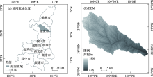
图1
延河流域地理位置"

表1
研究数据和处理方法"
| 数据 | 数据来源 | 时间 | 空间分辨率/m | 处理方法 | |
|---|---|---|---|---|---|
| 影像 数据 | Landsat TM | 地理空间数据云 http://www.gscloud.cn/ | 1998年6月16日 2004年6月14日 2010年6月30日 | 30 | 辐射定标、大气校正、影像拼接和裁剪等预处理 |
| Landsat OLI | 地理空间数据云 http://www.gscloud.cn/ | 2016年6月17日 | 30 | 辐射定标、大气校正、影像拼接和裁剪等预处理 | |
| 辅助 数据 | DEM | 地理空间数据云 http://www.gscloud.cn/ | 2009年 | 30 | 投影变换、拼接和裁剪 |
| 逐日降雨和温度数据 | 中国科学院资源环境科学与数据中心 https://www.resdc.cn/ | 1996年、1998年、2000年、2002年、2004年、2006年、2008年、2010年、2012年、2014年、2016年、2018年 | 30 | 选取研究区内、外共27个站点数据,计算各站点年均温度和年降水量,采用反距离插值法将计算得到的数据插值为空间分辨率与遥感影像一致的栅格数据,求取均值 | |
| 人口和GDP | 陕西省统计年鉴 | 1998—2019年 | - | 对延河流域各县人口数据和GDP数据进行统计 | |
表2
各指标公式"
| 指标 | 公式 | 参数说明 |
|---|---|---|
| NDVI | | Red为红波段反射率;NIR为近红外波段反射率。分别可对应Landsat5 TM的3、4波段反射率和Landsat8 OLI的4、5波段反射率 |
| Wet | | |
| NDBSI | | |
| LST | | DN为Landsat数据像元的灰度值;gain和bias分别为波段增益值和偏置值;L6代表TM/TIRS热红外波段的辐射值;K1和K2为定标参数;Tb为亮度温度;λ为TM影像第6波段的中心波长11.5 μm和OLI数据的第10波段中心波长10.9 μm;ρ等于1.438×10⁻² mK;ε为比辐射率 |
表3
1998年、2004年、2010年和2016年各指标主成分分析结果"
| 年份 | 参数 | 第一主成分 | 第二主成分 | 第三主成分 | 第四主成分 |
|---|---|---|---|---|---|
| 1998 | NDVI | 0.521 | 0.420 | -0.383 | 0.636 |
| Wet | 0.525 | -0.102 | 0.834 | 0.139 | |
| NDBSI | -0.530 | -0.340 | 0.166 | 0.759 | |
| LST | -0.414 | 0.835 | 0.362 | 0.006 | |
| 特征值 | 0.137 | 0.022 | 0.008 | 0.000 | |
| 特征值贡献率/% | 81.640 | 13.350 | 4.850 | 0.160 | |
| 2004 | NDVI | 0.493 | 0.418 | -0.478 | -0.595 |
| Wet | 0.514 | 0.119 | 0.834 | -0.161 | |
| NDBSI | -0.534 | -0.242 | 0.213 | -0.782 | |
| LST | -0.456 | 0.868 | 0.175 | 0.091 | |
| 特征值 | 0.126 | 0.021 | 0.009 | 0.001 | |
| 特征值贡献率/% | 79.950 | 13.150 | 5.680 | 0.870 | |
| 2010 | NDVI | 0.548 | 0.328 | -0.388 | 0.665 |
| Wet | 0.547 | 0.003 | 0.837 | 0.036 | |
| NDBSI | -0.541 | -0.223 | 0.322 | 0.744 | |
| LST | -0.329 | 0.918 | 0.214 | -0.057 | |
| 特征值 | 0.138 | 0.019 | 0.006 | 0.001 | |
| 特征值贡献率/% | 84.050 | 11.610 | 3.570 | 0.770 | |
| 2016 | NDVI | 0.565 | 0.298 | -0.548 | 0.541 |
| Wet | 0.502 | 0.061 | 0.819 | 0.273 | |
| NDBSI | -0.558 | -0.216 | 0.093 | 0.796 | |
| LST | -0.344 | 0.928 | 0.144 | -0.006 | |
| 特征值 | 0.167 | 0.021 | 0.004 | 0.001 | |
| 特征值贡献率/% | 86.720 | 10.710 | 2.280 | 0.290 |
表4
各年份4个指标和RSEI的统计值"
| 年份 | 参数 | NDVI | Wet | NDBSI | LST | RSEI |
|---|---|---|---|---|---|---|
| 1998 | 均值 | 0.322 | 0.478 | 0.685 | 0.507 | 0.392 |
| 对PC1荷载值 | 0.521 | 0.525 | -0.530 | -0.414 | - | |
| 2004 | 均值 | 0.323 | 0.507 | 0.675 | 0.513 | 0.410 |
| 对PC1荷载值 | 0.493 | 0.514 | -0.534 | -0.456 | - | |
| 2010 | 均值 | 0.471 | 0.503 | 0.619 | 0.539 | 0.441 |
| 对PC1荷载值 | 0.548 | 0.547 | -0.541 | -0.329 | - | |
| 2016 | 均值 | 0.581 | 0.565 | 0.504 | 0.420 | 0.530 |
| 对PC1荷载值 | 0.565 | 0.502 | -0.558 | -0.344 | - |
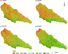
图2
延河流域1998年、2004年、2010年和2016年遥感生态指数"

表5
流域1998—2016年遥感生态指数各等级面积统计"
| RSEI 等级 | 1998年 | 2004年 | 2010年 | 2016年 | 均值 | |||||||||
|---|---|---|---|---|---|---|---|---|---|---|---|---|---|---|
| 面积/km2 | 占比/% | 面积/km2 | 占比/% | 面积/km2 | 占比/% | 面积/km2 | 占比/% | 面积/km2 | 占比/% | |||||
| 很差 | 1240.430 | 16.2 | 1344.149 | 17.6 | 948.261 | 12.4 | 687.401 | 9.0 | 1055.060 | 13.8 | ||||
| 较差 | 3123.612 | 40.9 | 2731.561 | 35.7 | 2563.76 | 33.5 | 1650.651 | 21.6 | 2517.396 | 32.9 | ||||
| 中等 | 2177.107 | 28.5 | 2167.987 | 28.3 | 2428.126 | 31.8 | 2229.879 | 29.2 | 2250.775 | 29.5 | ||||
| 良好 | 706.533 | 9.3 | 878.767 | 11.5 | 1252.57 | 16.4 | 1969.7 | 25.8 | 1201.892 | 15.7 | ||||
| 优良 | 390.561 | 5.1 | 528.387 | 6.9 | 452.606 | 5.9 | 1103.360 | 14.4 | 618.729 | 8.1 | ||||
| 合计 | 7638.244 | 100.00 | 7650.851 | 100.00 | 7645.323 | 100.00 | 7640.991 | 100.00 | 7643.852 | 100.00 | ||||
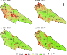
图3
延河流域生态环境质量变化时空分布"

表6
延河流域生态等级变化统计"
| 类别 | 差值 | 1998—2004年 | 2004—2010年 | 2010—2016年 | 1998—2016年 | |||||||
|---|---|---|---|---|---|---|---|---|---|---|---|---|
| 面积/km2 | 占比/% | 面积/km2 | 占比/% | 面积/km2 | 占比/% | 面积/km2 | 占比/% | |||||
| 变差 | -4 | 0.118 | 0.000 | 0.572 | 0.010 | 2.343 | 0.030 | 1.577 | 0.020 | |||
| -3 | 2.410 | 0.030 | 6.343 | 0.080 | 12.629 | 0.170 | 13.319 | 0.170 | ||||
| -2 | 68.338 | 0.890 | 67.848 | 0.890 | 64.073 | 0.840 | 116.252 | 1.520 | ||||
| -1 | 1198.591 | 15.690 | 1224.513 | 16.020 | 506.432 | 6.630 | 891.650 | 11.690 | ||||
| 不变 | 0 | 4499.537 | 58.910 | 4238.542 | 55.460 | 3571.693 | 46.770 | 2596.093 | 34.020 | |||
| 变好 | 1 | 1764.221 | 23.100 | 1737.903 | 22.740 | 2894.729 | 37.910 | 2328.290 | 30.510 | |||
| 2 | 99.059 | 1.300 | 286.970 | 3.750 | 518.229 | 6.790 | 1085.440 | 14.230 | ||||
| 3 | 5.306 | 0.070 | 69.857 | 0.910 | 63.083 | 0.830 | 449.429 | 5.890 | ||||
| 4 | 0.428 | 0.010 | 10.327 | 0.140 | 3.549 | 0.050 | 148.193 | 1.940 | ||||
表7
多元线性回归方程"
| 区域 | 样本点数 | 多元线性回归方程 | R | R2 | P |
|---|---|---|---|---|---|
| a | 158 | RSEIi=1.688+0.147NDVIi+0.347Weti-0.363NDBSIi-0.009LSTi | 0.789 | 0.622 | <0.01 |
| b | 300 | RSEIi=2.332+0.086NDVIi+0.199Weti-0.238NDBSIi-0.220LSTi | 0.585 | 0.342 | <0.01 |
| c | 250 | RSEIi=2.520+0.012NDVIi+0.195Weti-0.384NDBSIi-0.032LSTi | 0.643 | 0.413 | <0.01 |
| d | 534 | RSEIi=1.335+0.150NDVIi+0.368Weti-0.188NDBSIi-0.090LSTi | 0.641 | 0.411 | <0.01 |
| e | 100 | RSEIi=1.201+0.385NDVIi+0.263Weti-0.131NDBSIi-0.112LSTi | 0.772 | 0.596 | <0.01 |
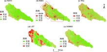
图4
1998—2016年延河流域各指标变化"

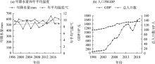
图5
延河流域多年气候和社会经济情况"


图6
不同海拔不同等级生态质量所占比"

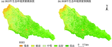
图7
2022年(a)模拟与2028年(b)预测结果"

| [1] | 赵其国, 黄国勤, 马艳芹. 中国生态环境状况与生态文明建设[J]. 生态学报, 2016, 36(19): 6328-6335. |
| [ Zhao Qiguo, Huang Guoqin, Ma Yanqin. The ecological environment conditions and construction of an ecological civilization in China[J]. Acta Ecologica Sinica, 2016, 36(19): 6328-6335. ] | |
| [2] | 陈博明. 遥感技术在生态环境监测及执法中的应用进展[J]. 矿冶工程, 2020, 40(4): 165-168, 173. |
| [ Chen Boming. Progress in the application of remote sensing technology to ecological environment monitoring and law enforcement supervision[J]. Mining And Metallurgical Engineering, 2020, 40(4): 165-168, 173. ] | |
| [3] |
谢芳, 邱国玉, 尹婧, 等. 泾河流域40年的土地利用/覆盖变化分区对比研究[J]. 自然资源学报, 2009, 24(8): 1354-1365.
doi: 10.3390/su12187716 |
|
Xie Fang, Qiu Guoyu,imu A, Zhao Y Y, et al. Evaluation of the temporal and spatial changes of ecological quality in the Hami oasis based on RSEI[J]. Sustainability, 2020, 12(18): 7716-7738.
doi: 10.3390/su12187716 |
|
| [4] | 陈福军, 沈彦俊, 李倩, 等. 中国陆地生态系统近30年NPP时空变化研究[J]. 地理科学, 2011, 31(11): 1409-1414. |
| [ Chen Fujun, Shen Yanjun, Li Qian, et al. Spatio-temporal variationan alysis of ecological systems NPP in China in past 30 years[J]. Science Geo-graphica sinica, 2011, 31(11): 1409-1414. ] | |
| [5] | 王志成, 刘新华, 贾付生, 等. 近10a阿克苏流域植被覆盖时空演变特征及影响因素[J]. 长江科学院院报, 2017, 34(9): 24-28, 35. |
| [ Wang Zhicheng, Liu Xinhua, Jia Fusheng, et al. Vegetation cover in Aksu River Basin over the past decade: Spatio-temporal variation and impact factors[J]. Journal of Yangtze River Scientific Research Institute, 2017, 34(9): 24-28, 35. ] | |
| [6] | 林雷余, 谢先德, 孙鸿良, 等. 浙江省萧山县山-村农业结构现状及生态农业建设对策[J]. 农村生态环境, 1987, 4(1): 1-6. |
| [ Lin Leiyu, Xie Xiande, Sun Hongliang, et al. Present situation of agricultural structure and countermeasures of ecological agricul-ture construction in Shanyi Village of Xiaoshan County, Zhejiang Province[J]. Journal of Ecology and Rural Environment, 1987, 4(1): 1-6. ] | |
| [7] | 程春明, 李蔚, 宋旭. 生态环境大数据建设的思考[J]. 中国环境管理, 2015, 7(6): 9-13. |
| [ Cheng Chunming, Li Wei, Song Xu. Thinking on the big data construction for ecological environment[J]. Chinese Journal of Environmental Management, 2015, 7(6): 9-13. ] | |
| [8] | 高鹏文, 阿里木江·卡斯木, 图尔荪阿依·如孜,等. 哈密市生态环境效益时空分析[J]. 干旱区研究, 2020, 37(4): 1057-1067. |
| [ Gao Pengwen, Kasim Alimujiang, Ruzi Tursunayi, et al. Temporal and spatial analysis of ecological environmentim provement in Ha-mi City[J]. Arid Zone Research, 2020, 37(4): 1057-1067. ] | |
| [9] | 徐涵秋. 区域生态环境变化的遥感评价指数[J]. 中国环境科学, 2013, 33(5): 889-897. |
| [ Xu Hanqiu. Remote sensing evaluation in-dex of regional ecological environment change[J]. China Environ-mental Science, 2013, 33(5): 889-897. ] | |
| [10] | 张晓东, 刘湘南, 赵志鹏, 等. 农牧交错区生态环境质量遥感动态监测--以宁夏盐池为例[J]. 干旱区地理, 2017, 40(5): 1070-1078. |
| [ Zhang Xiaodong, Liu Xiangnan, Zhao Zhipeng, et al. Dynamic monitoring of ecology and environment in the agro-pas-tral ecotone based on remote sensing: A case of Yanchi County in Ningxia Hui Autonomous Region[J]. Arid Land Geography, 2017, 40(5): 1070-1078. ] | |
| [11] | 徐涵秋, 施婷婷, 王美雅, 等. 雄安新区地表覆盖变化及其新区规划的生态响应预测[J]. 生态学报, 2017, 37(19): 6289-6301. |
| [ Xu Hanqiu, Shi Tingting, Wang Meiya, et al. Land cover changes in the Xiong’an New Area and a prediction of ecological response to forthcoming regional planning[J]. Acta Ecologica Sinica, 2017, 37(19): 6289-6301. ] | |
| [12] |
Gao P W, Kasimu A, Zhao Y Y, et al. Evaluation of the temporal and spatial changes of ecological quality in the Hami oasis based on RSEI[J]. Sustainability, 2020, 12(18): 7716-7738.
doi: 10.3390/su12187716 |
| [13] |
Huang H P, Chen W, Zhang Y, et al. Analysis of ecological quality in Lhasa Metropolitan Area during 1990-2017 based on remote sensing and Google Earth Engine platform[J]. Journal of Geographical Sciences, 2021, 31(2): 265-280.
doi: 10.1007/s11442-021-1846-8 |
| [14] | 韩磊, 朱会利, 刘钊. 延安市退耕还林前后土地利用动态变化分析[J]. 西北师范大学学报(自然科学版), 2017, 53(5): 101-108. |
| [ Han Lei, Zhu Huili, Liu Zhao. Analysis on dynamic change of land use before and after conversion of farmland to forest in yan’an city[J]. Journal of Northwest Normal University (Natural Science), 2017, 53(5): 101-108. ] | |
| [15] | 王丽霞, 任志远, 任朝霞, 等. 延河流域NDVI与主要气候因子的时空相关性研究[J]. 干旱区资源与环境, 2011, 25(8): 88-93. |
| [ Wang Lixia, Ren Zhiyuan, Ren Zhaoxia, et al. The temporal and spatial correlations between NDVI and main climatic factors in Yanhe watershed[J]. Journal of Arid Land Resources and Environment, 2011, 25(8): 88-93. ] | |
| [16] | 董贞凯, 穆兴民, 赵广举, 等. 延河流域侵蚀产沙对有效降雨量及植被恢复的响应[J]. 泥沙研究, 2020, 45(5): 27-33. |
| [ Dong Zhenkai, Mu Xingmin, Zhao Guangju, et al. Response of sediment yield to effective rainfall and vegetation rehabilitation in the Yanhe River Basin[J]. Journal of Sediment Research, 2020, 45(5): 27-33. ] | |
| [17] | 王丽春, 焦黎, 来风兵, 等. 基于遥感生态指数的新疆玛纳斯湖湿地生态变化评价[J]. 生态学报, 2019, 39(8): 2963-2972. |
| [ Wang Lichun, Jiao Li, Lai Fengbing, et al.. Evaluation of ecological changes based on a remote sensing ecological index in a Manas Lake wetland, Xinjiang[J]. Acta Ecologica Sinica, 2020, 39(8): 2963-2972. ] | |
| [18] | 徐涵秋. 利用改进的归一化差异水体指数(MNDWI)提取水体信息的研究[J]. 遥感学报, 2005, 4(5): 589-595. |
| [ Xu Hanqiu. A study on information extraction of water body with the modified normalized difference water index (MNDWI)[J]. Journal of Remote Sensing, 2005, 4(5): 589-595. ] | |
| [19] |
Sobrino J A, Jiménez-Muñoz J C, Paolini L. Land surface temperature retrieval from LANDSAT TM5[J]. Remote Sensing of Environment, 2004, 90(4): 434-440.
doi: 10.1016/j.rse.2004.02.003 |
| [20] | 覃志豪, Li Wenjuan, Zhang Minghua, 等. 单窗算法的大气参数估计方法[J]. 国土资源遥感, 2003, 56(2): 37-43. |
| [ Qin Zhihao, Li Wenjuan, Zhang Minghua, et al. Estimating of the essential atmospheric parameters of mono-window algorithm for land surface temperature retrieval from Landsat TM6[J]. Remote Sensing for Land & Resources, 2003, 56(2): 37-43. ] | |
| [21] | 胡德勇, 乔琨, 王兴玲, 等. 单窗算法结合Landsat8热红外数据反演地表温度[J]. 遥感学报, 2015, 19(6): 964-976. |
| [ Hu Deyong, Qiao Kun, Wang Xingling, et al. Land surface temperature retrieval from Landsat 8 thermal infrared data using mono-window algorithm[J]. Journal of Remote Sensing, 2015, 19(6) : 964-976. ] | |
| [22] |
赵永华, 贾夏, 刘建朝, 等. 基于多源遥感数据的景观格局及预测研究[J]. 生态学报, 2013, 33(8): 2556-2564.
doi: 10.5846/stxb201106190846 |
|
[ Zhao Yonghua, Jia Xia, Liu Jianchao, et al. Analysis and forecast of landscape pattern in Xi’an from 2000 to 2011[J]. Acta Ecologica Sinica, 2013, 33(8): 2556-2564. ]
doi: 10.5846/stxb201106190846 |
|
| [23] | 农兰萍, 王金亮. 基于RSEI模型的昆明市生态环境质量动态监测[J]. 生态学杂志, 2020, 39(6): 2042-2050. |
| [ Nong Lanping, Wang Jinliang. Dynamic monitoring of ecological environment quality in Kunming based on RSEI model[J]. Chinese Journal of Ecology, 2020, 39(6): 2042-2050. ] | |
| [24] |
韩磊, 火红, 刘钊, 等. 基于地形梯度的黄河流域中段植被覆盖时空分异特征--以延安市为例[J]. 应用生态学报, 2021, 32(5): 1581-1592.
doi: 10.13287/j.1001-9332.202105.014 pmid: 34042352 |
|
[ Han Lei, Huo Hong, Liu Zhao, et al. Spatial-temporal variation of vegetation cover in the middle Yellow River Basin based on topographic gradient: A case study of Yan’an City[J]. Chinese Journal of Applied Ecology, 2021, 32(5): 1581-1592. ]
doi: 10.13287/j.1001-9332.202105.014 pmid: 34042352 |
|
| [25] | 周易. 西北地区削山填壑后的生境协同修复--以延安新区学习书院山体公园项目为例[J]. 工程建设与设计, 2019, 63(19): 141-144. |
| [ Zhou Yi. Collaborative restoration of habitats after mountain cutting and reclamation in Northwest China: Taking the learning academy and the mountain park project in Yan’an New District as an example[J]. Environment Engineering Design, 2019, 63(19): 141-144. ] | |
| [26] | 翟睿洁, 赵文武, 贾立志. 基于RUSLE、InVEST和USPED的土壤侵蚀量估算对比研究--以陕北延河流域为例[J]. 农业现代化研究, 2020, 41(6): 1059-1068. |
| [ Zhai Ruijie, Zhao Wenwu, Jia Lizhi. A comparative study of soil erosion estimation based on RUSLE, InVEST and USPED models: A case study of the Yanhe River Basin in Northern Shaanxi[J]. Research of Agricultural Modernization, 2020, 41(6): 1059-1068. ] | |
| [27] | 邓振镛, 林日暖, 刘丽君. 影响我省土壤湿度的因素及其分布[J]. 甘肃气象, 1990, 17(3): 19-21. |
| [ Deng Zhenyong, Lin Rinuan, Liu Lijun. Factors affecting soil moisture and its distribution in Gansu Province[J]. Gansu Meteorology, 1990, 17(3): 19-21. ] | |
| [28] | 陈睿山, 郭晓娜, 熊波, 等. 气候变化、土地退化和粮食安全问题: 关联机制与解决途径[J]. 生态学报, 2021, 41(7): 2918-2929. |
| [ Chen Ruishan, Guo Xiaona, Xiong Bo, et al. Climate change, land degradation and food insecurity: Linkages and potential solutions[J]. Acta Ecologica Sinica, 2021, 41(7): 2918-2929. ] | |
| [29] | 柯锐鹏, 梅志雄. 城镇化与绿地退化对城市热环境影响研究[J]. 生态环境学报, 2010, 19(9): 2023-2030. |
| [ Ke Ruipeng, Mei Zhixiong. Analysis on the influence of urbanization and greenland-degradation on city thermal environment[J]. Ecology and Environmental Sciences, 2010, 19(9): 2023-2030. ] |
| [1] | 朱从祯,赵天良,孟露,杨兴华,何清,买买提艾力·买买提依明. 塔里木盆地浮尘滞空天气客观分型[J]. 干旱区研究, 2023, 40(9): 1391-1403. |
| [2] | 张泽宇, 吴晓静, 梁一鹏, 张晓霞, 查同刚. 乌拉山废弃矿山生态恢复的近自然植被空间配置模式[J]. 干旱区研究, 2023, 40(7): 1164-1171. |
| [3] | 刘笑, 郭鹏, 祁佳峰, 杜文玲, 张茹倩, 张坤. 基于MRSEI模型的阿勒泰市生态环境时空变化及驱动力分析[J]. 干旱区研究, 2023, 40(6): 1014-1026. |
| [4] | 牛子路, 王磊, 齐拓野, 张伊婧, 申建香, 杨竹青, 王恩田, 蒋淑汀. 宁夏红寺堡扬黄灌区土壤盐渍化特征[J]. 干旱区研究, 2023, 40(11): 1785-1796. |
| [5] | 王维璐,刘铁,罗格平. 基于可持续发展目标的吉尔吉斯斯坦水环境承载力评价[J]. 干旱区研究, 2022, 39(6): 1801-1809. |
| [6] | 曹永香,毛东雷,薛杰,苏松领,开买尔古丽·阿不来提,蔡富艳. 绿洲-沙漠过渡带植被覆盖动态变化及其驱动因素——以新疆策勒为例[J]. 干旱区研究, 2022, 39(2): 510-521. |
| [7] | 王毓芳,赵成章,曾红霞,康满萍,赵婷婷,唐玉瑞. 疏勒河中游湿地景观时空演变及其影响因素[J]. 干旱区研究, 2022, 39(1): 282-291. |
| [8] | 李梦怡,邓铭江,凌红波,王光焰,徐生武. 塔里木河下游水生态安全评价及驱动要素分析[J]. 干旱区研究, 2021, 38(1): 39-47. |
| [9] | 周利颖,李瑞平,苗庆丰,窦旭,田峰,于丹丹,孙晨云. 内蒙古河套灌区紧邻排干沟土壤盐渍化与肥力特征分析[J]. 干旱区研究, 2021, 38(1): 114-122. |
| [10] | 宋美杰, 罗艳云, 段利民. 基于改进遥感生态指数模型的锡林郭勒草原生态环境评价[J]. 干旱区研究, 2019, 36(6): 1521-1527. |
| [11] | 王巧焕,卢玉东,赛佳美,李环环. 干旱区绿洲土壤盐分特征分析[J]. 干旱区研究, 2018, 35(3): 503-509. |
| [12] | 许 茜, 李奇, 陈懂懂, 罗彩云, 赵新全, 赵 亮. 近40 a三江源地区土地利用变化动态分析及预测[J]. 干旱区研究, 2018, 35(3): 695-704. |
| [13] | 易浪, 任志远, 刘焱序. 西安市耕地面积变化驱动力分析及动态预测[J]. 干旱区研究, 2013, 30(6): 1144-1149. |
| [14] | 杨晓娟, 廖超英, 孙文艳, 包耀贤, 李陆平. 乌兰布和沙漠东北部沙区人工林土壤肥力质量评价[J]. 干旱区研究, 2012, 29(4): 604-608. |
|
||