干旱区研究 ›› 2021, Vol. 38 ›› Issue (1): 267-274.doi: 10.13866/j.azr.2021.01.28
刘冠1,2( ),李国庆2,3(),李洁1,2,张艳如3,鲁奇1,2,杜盛2,3
收稿日期:2020-04-07
修回日期:2020-08-05
出版日期:2021-01-15
发布日期:2021-03-05
通讯作者:
李国庆
作者简介:刘冠(1995-),女,硕士研究生,主要从事植被恢复与模型研究. E-mail: 基金资助:
LIU Guan1,2(),LI Guoqing2,3(),LI Jie1,2,ZHANG Yanru3,LU Qi1,2,DU Sheng2,3
Received:2020-04-07
Revised:2020-08-05
Online:2021-01-15
Published:2021-03-05
Contact:
Guoqing LI
摘要:
区域碳储量是生态系统功能的重要度量指标,探索土地改造对区域碳储量变化的影响,对于协调区域生态建设和生态产业发展具有重要意义。基于InVEST模型和地理信息系统技术,研究了陕西省延安南部麻塔流域1999—2016年土地结构改造过程中区域碳储量变化,并探讨坡度、坡向、坡位对碳储量空间分布的影响。结果表明:麻塔流域18 a的土地改造使得区域碳储量增加1688.36 Mg(碳密度增加6.92 Mg·hm2),总固碳功能提升约7.63%。森林、草地和果园土地类型面积的增加是植被转换后流域景观碳储量提升的主要贡献者。碳储量增加的空间位置主要分布在半阴坡、中上坡位以及坡度10°~30°。本研究认为林草植被建设和经济果林建设两者都有利于增强麻塔流域景观固碳能力。麻塔流域土地转换模式能够协调区域生态建设和生态产业的发展,在黄土丘陵区具有较好的推广价值。
刘冠,李国庆,李洁,张艳如,鲁奇,杜盛. 基于InVEST模型的1999—2016年麻塔流域碳储量变化及空间格局研究[J]. 干旱区研究, 2021, 38(1): 267-274.
LIU Guan,LI Guoqing,LI Jie,ZHANG Yanru,LU Qi,DU Sheng. Study on change in carbon storage and its spatial pattern in Mata Watershed from 1999 to 2016 based on InVEST model[J]. Arid Zone Research, 2021, 38(1): 267-274.
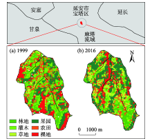
图1
麻塔流域位置及1999年和2016年土地利用类型"

表1
1999—2016年麻塔流域土地利用类型面积转移矩阵"
| 1999年 | 2016年 | ||||||
|---|---|---|---|---|---|---|---|
| 森林 | 灌木 | 草地 | 果园 | 农田 | 其他 | 合计 | |
| 森林 | 5.21 | 2.07 | 1.96 | 1.94 | 0.27 | 0.15 | 11.60 |
| 灌木 | 7.53 | 15.23 | 17.96 | 26.32 | 3.08 | 6.66 | 76.78 |
| 草地 | 0.83 | 1.06 | 4.99 | 10.37 | 1.55 | 2.66 | 21.46 |
| 果园 | 6.10 | 8.59 | 20.43 | 43.07 | 2.68 | 3.27 | 84.14 |
| 农田 | 0.11 | 0.53 | 3.38 | 12.01 | 1.28 | 1.85 | 19.16 |
| 其他 | 0.15 | 0.35 | 5.86 | 21.26 | 1.05 | 0.67 | 29.34 |
| 合计 | 19.93 | 27.83 | 54.58 | 114.97 | 9.91 | 15.26 | 242.48 |
表2
麻塔流域土地利用固碳参数(碳密度)"
| 土地利用类型 | 编码 | 地上生物碳密度/(Mg·hm2) | 地下生物碳密度/(Mg·hm2) | 土壤碳密度/(Mg·hm2) | 死亡有机碳密度/(Mg·hm2) |
|---|---|---|---|---|---|
| 森林 | 1 | 44.60 | 11.10 | 106.10 | 1.90 |
| 灌木 | 2 | 7.59 | 4.00 | 80.50 | 0.80 |
| 草地 | 3 | 1.34 | 10.07 | 85.40 | 0.45 |
| 果园 | 4 | 14.10 | 5.60 | 76.00 | 0.03 |
| 农田 | 5 | 3.00 | 0.68 | 76.83 | 0.07 |
| 其他 | 6 | 0.00 | 0.00 | 40.90 | 0.00 |
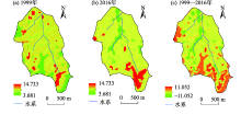
图2
1999年和2016年碳储量空间格局及1999—2016年碳储量变化"

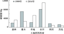
图3
1999年和2016年麻塔流域不同土地利用类型碳储量"
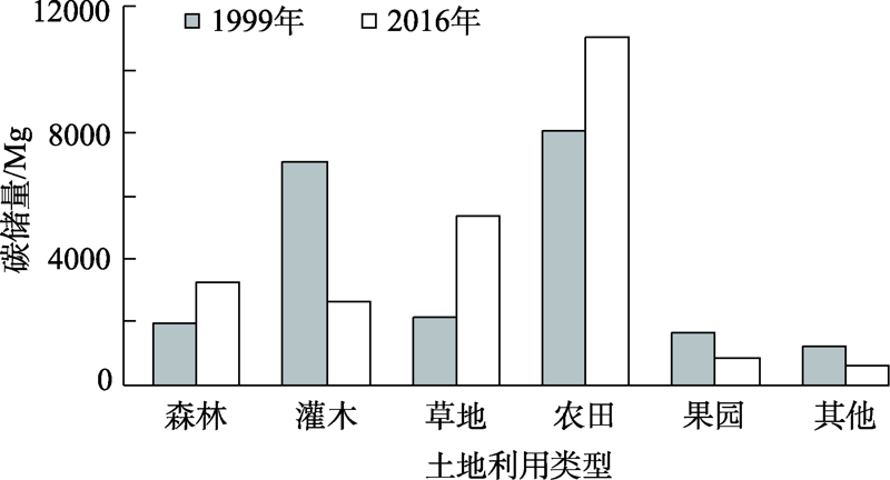
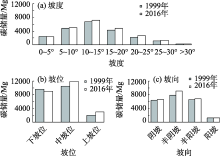
图4
麻塔流域地形因子对碳储量的影响"

| [1] |
Piao S L, Fang J Y, Ciais P, et al. The carbon balance of terrestrial ecosystems in China[J]. Nature, 2009,458(7241):1009-1013.
doi: 10.1038/nature07944 pmid: 19396142 |
| [2] | 方精云, 于贵瑞, 任小波, 等. 中国陆地生态系统固碳效应: 中国科学院战略性先导科技专项“应对气候变化的碳收支认证及相关问题”之生态系统固碳任务群研究进展[J]. 中国科学院院刊, 2015,30(6):848-857, 875. |
| [ Fang Jingyun, Yu Guirui, Ren Xiaobo, et al. Carbon sequestration in China’s terrestrial ecosystems under climatechange: Progress on ecosystem carbon sequestration from the CAS strategic priority research program[J]. Bulletin of the Chinese Academy of Sciences, 2015,30(6):848-857, 875. ] | |
| [3] | 戴尔阜, 黄宇, 吴卓, 等. 内蒙古草地生态系统碳源/汇时空格局及其与气候因子的关系[J]. 地理学报, 2016,71(1):21-34. |
| [ Dai Erfu, Huang Yu, Wu Zhuo, et al. Spatial-temporal features of carbon source-sink and its relationship with climate factors in Inner Mongolia grassland ecosystem[J]. Acta Geographica Sinica, 2016,71(1):21-34. ] | |
| [4] | Han Y W, Zhang S, Yin L H. Quantifying the carbon storage capacity and its spatial distribution patterns of green spaces in a metropolitan area: A case study of Seoul, South Korea[J]. Landscape Architecture Frontiers, 2019,7(2):55-65. |
| [5] | Oubrahim H, Boulmane M, Bakker M R, et al. Carbon storage in degraded cork oak (Quercus suber) forests on flat lowlands in Morocco[J]. Forest-Biogeosciences and Forestry, 2015,9(1):125-137. |
| [6] | 张景群, 苏印泉, 康永祥, 等. 黄土高原刺槐人工林幼林生态系统碳吸存[J]. 应用生态学, 2009,20(12):2911-2916. |
| [ Zhang Jingqun, Su Yinquan, Kang Yongxiang, et al. Carbon sequestration of young Robinia pseudoacacia plantation in Loess Plateau[J]. Chinese Journal of Applied Ecology, 2009,20(12):2911-2916. ] | |
| [7] | Li F C, Zhang J H, Su Z G, et al. Simulation and 137Cs tracer show tillage erosion translocating soil organic carbon, phosphorus, and potassium[J]. Journal of Plant Nutrition and Soil Science, 2013,176:647-654. DOI: 10.1002/jpln.201200341. |
| [8] | 张云倩, 张晓祥, 陈振杰, 等. 基于InVEST模型的江苏海岸带生态系统碳储量时空变化研究[J]. 水土保持研究, 2016,23(3):100-105. |
| [ Zhang Yunqian, Zhang Xiaoxiang, Chen Zhenjie, et al. Research on the spatiotemporal variation of carbon storage in coastal zone ecosystem of Jiangsu based on InVEST model[J]. Research of Soil and Water Conservation, 2016,23(3):100-105. ] | |
| [9] | Richard S, Rebecca C K, Spencer W, et al. InVEST 3. 2. 0 User’s Guide[M]. Stanford: Natural Capital Project, Stanford University, University Nature Conservancy, World Wildlife Fund, 2015. |
| [10] |
Rebecca C K, Sharp R P, Mandle L, et al. Spatial patterns of agricultural expansion determine impacts on biodiversity and carbon storage[J]. Proceedings of the National Academy of Sciences of the United States of America, 2015,112(24):7402-7407.
pmid: 26082547 |
| [11] |
Goldstein J H, Caldarone G, Duarte T K, et al. Integrating ecosystem-service tradeoffs into land-use decisions[J]. Proceedings of the National Academy of Sciences of the United States of America, 2012,109(19):7565-7570.
pmid: 22529388 |
| [12] | Bhagabati N K, Ricketts T, Sulistyawan T B S, et al. Ecosystem services reinforce Sumatran tiger conservation in land use plans[J]. Biological Conservation, 2014,169(387):147-156. |
| [13] | Fisher B, Turner R K, Burgess N D, et al. Measuring, modeling and mapping ecosystem services in the Eastern Arc Mountains of Tanzania[J]. Progress in Physical Geography, 2011,35(5):595-611. |
| [14] | 彭怡. InVEST模型在生态系统服务功能评估中的应用研究——以四川汶川地震灾区为例[D]. 成都: 中国科学院水利部山地灾害与环境研究所, 2010. |
| [ Peng Yi. Application of InVEST Model in Ecosystem Services Assessment: A Case Study from Wenchuan Earthquake Area A bstract[D]. Chengdu: Institute of Mountain Hazards and Environment Chinese Academy of Sciences & Ministry Water Conservancy, 2010. ] | |
| [15] | 吕一河, 胡健, 孙飞翔, 等. 水源涵养与水文调节: 和而不同的陆地生态系统水文服务[J]. 生态学报, 2015,35(15):5191-5196. |
| [ Lyu Yihe, Hu Jian, Sun Feixiang, et al. Water retention and hydrological regulation: Harmony but not the same in terrestrial hydrological ecosystem services[J]. Acta Ecologica Sinica, 2015,35(15):5191-5196. ] | |
| [16] | 杨芝歌, 周彬, 余新晓, 等. 北京山区生物多样性分析与碳储量评估[J]. 水土保持通报, 2012,32(3):42-46. |
| [ Yang Zhige, Zhou Bin, Yu Xinxiao, et al. Biodiversity analysis and carbon storage assessments in Beijing mountainous areas[J]. Bulletin of Soil and Water Conservation, 2012,32(3):42-46. ] | |
| [17] | 陈童尧, 贾燕锋, 王佳楠, 等. 基于InVEST模型的祁连山国家级自然保护区土壤保持现状与功能[J]. 干旱区研究, 2020,37(1):150-159. |
| [ Chen Tongyao, Jia Yanfeng, Wang Jianan, et al. Current situation and function of soil conservation in national nature reserves in the Qilian Mountains based on InVEST model[J]. Arid Zone Research, 2020,37(1):150-159. ] | |
| [18] | Spencer C N, Matzner S L, Smalley J, et al. Forest expansion and soil carbon changes in the Loess Hills of Eastern South Dakota[J]. American Midland Naturalist, 2009,161(2):273-285. ] |
| [19] | 李泽, 郭胜利, 张芳, 等. 退耕还果对黄土高原沟壑区坡地土壤和植被碳、氮储量的影响[J]. 植物营养与肥料学报, 2011,17(4):919-924. |
| [ Li Ze, Guo Shengli, Zhang Fang, et al. Effects of apple orchard converted from cropland on C and N storages in terrestrial system of slopping cultivated land in the Loess Gully Regions[J]. Plant Nutrition and Fertilizer Science, 2011,17(4):919-924. ] | |
| [20] | 李国庆, 温仲明, 杜盛. 延安麻塔流域植被对土壤侵蚀的控制效率研究[J]. 国土与自然资源研究, 2019(6):64-68. |
| [ Li Guoqing, Wen Zhongming, Du Sheng. Study on the control efficiency of vegetation on soil erosion in Mata Watershed of Yanan City[J]. Territory & Natural Resources Study, 2019(6):64-68. ] | |
| [21] | 刘涛. 宁南黄土丘陵26年生主要人工灌木林碳密度及其分配特征[J]. 安徽农业科学, 2018,46(4):103-105. |
| [ Liu Tao. Carbon density and its allocation characteristics of 26-year-old major shrub plantations in Hilly Loess Plateau, South Ningxia[J]. Journal of Anhui Agricultural Sciences, 2018,46(4):103-105. ] | |
| [22] | 张娜, 梁一民. 黄土丘陵区天然草地地下/地上生物量的研究[J]. 草业学报, 2002,11(2):72-78. |
| [ Zhang Na, Liang Yimin. Studies on the below-ground/above-ground biomass ratio of natural grassland in Loess Hilly region[J]. Acta Prataculturae Sinica, 2002,11(2):72-78. ] | |
| [23] | 艾泽民, 陈云明, 曹扬. 黄土丘陵区不同林龄刺槐人工林碳、氮储量及分配格局[J]. 应用生态学报, 2014,25(2):333-341. |
| [ Ai Zemin, Chen Yunming, Cao Yang. Storage and allocation of carbon and nitrogen in Robinia pseudoacacia plantation at different ages in the Loess Hilly region, China[J]. Chinese Journal of Applied Ecology, 2014,25(2):333-341. ] | |
| [24] | 程积民, 程杰, 杨晓梅, 等黄土高原草地植被碳密度的空间分布特征[J]. 生态学报, 2012,32(1):226-237. |
| [ Cheng Jimin, Cheng Jie, Yang Xiaomei, et al. Spatial distribution of carbon density in grassland vegetation of the Loess Plateau of China[J]. Acta Ecologica Sinica, 2012,32(1):226-237. ] | |
| [25] | 高阳, 马虎, 程积民, 等. 黄土高原半干旱区不同封育年限草地生态系统碳密度[J]. 草地学报, 2016,24(1):28-34. |
| [ Gao Yang, Ma Hu, Cheng Jimin, et al. Ecosvstem carbon density of grasslands under different grazing exclusion ages in semiarid region of the Loess Plateau[J]. Acta Agrestia Sinica, 2016,24(1):28-34. ] | |
| [26] | 杨晓梅, 程积民, 孟蕾. 黄土高原天然柴松林碳储量与碳密度特征[J]. 中国水土保持科学, 2010,8(2):41-45, 58. |
| [ Yang Xiaomei, Cheng Jimin, Meng Lei. Carbon storage and density features of natural forest of Pinus tabulaeformis fshekannesis in Loess Plateau[J]. Soil and Water Conservationu, 2010,8(2):41-45, 58. ] | |
| [27] | 李克让, 王绍强, 曹明奎. 中国植被和土壤碳贮量[J]. 中国科学: 地球科学, 2003,33(1):72-80. |
| [ Li Kerang, Wang Shaoqiang, Cao Mingkui. Vegetation and soil carbon storage in China[J]. Science China Earth Sciences, 2003,33(1):72-80. ] | |
| [28] | 刘建华, 许皞, 王耀, 等. 基于土地利用格局变化的生态风险与固碳功能评价——以河北省黄骅市为例[J]. 中国生态农业学报, 2018,26(8):1217-1226. |
| [ Liu Jianhua, Xu Hao, Wang Yao, et al. Evaluation of ecological risk and carbon fixation from land use change: A case study of Huanghua City, Hebei Province[J]. Chinese Journal of Eco-Agriculture, 2018,26(8):1217-1226. ] | |
| [29] |
Tang X L, Zhao X, Bai Y F, et al. Carbon pools in China’s terrestrial ecosystems: New estimates based on an intensive field survey[J]. Proceedings of the National Academy of Sciences of the United States of America, 2018,115(16). DOI: 10.1073/pnas.1700291115.
doi: 10.1073/pnas.1804001115 pmid: 29615511 |
| [30] | Cozarab A, Ferratic R, Garciaa C M, et al. Human-threatened ecosystem: New signs of groundwater connection between Yacyreta reservoir and Ibera wetland (South America)[J]. Science of the Total Environment, 2005,337(1):281-286. |
| [31] | 李双成, 张才玉, 刘金龙, 等. 生态系统服务权衡与协同研究进展及地理学研究议题[J]. 地理研究, 2013,32(8):1379-1390. |
| [ Li Shuangcheng, Zhang Caiyu, Liu Jinlong, et al. The tradeoffs and synergies of ecosystem services: Research progress, development trend, and themes of geography[J]. Geographical Research, 2013,32(8):1379-1390. ] | |
| [32] | 王森, 王海燕, 谢永生, 等. 延安市退耕还林前后土壤保持生态服务功能评价[J]. 水土保持研究, 2019,26(1):280-286. |
| [ Wang Sen, Wang Haiyan, Xie Yongsheng, et al. Evaluation of ecological service function of soil conservation before and after grain for green project in Yan’an City[J]. Research of Soil and Water Conservation, 2019,26(1):280-286. ] | |
| [33] | 邓元杰, 姚顺波, 侯孟阳, 等. 退耕还林还草工程对生态系统碳储存服务的影响——以黄土高原丘陵沟壑区子长县为例[J]. 自然资源学报, 2020,35(4):826-844. |
| [ Deng Yuanjie, Yao Shunbo, Hou Mengyang, et al. Assessing the effects of the green for grain program on ecosystem carbon storage service by linking the InVEST and FLUS models: A case study of Zichang county in hilly and gully region of Loess Plateau[J]. Journal of Natural Resources, 2020,35(4):826-844. ] | |
| [34] | 荣检. 基于InVEST模型的广西西江流域生态系统产水与固碳服务功能研究[D]. 南宁: 广西师范学院, 2017. |
| [ Rong Jian. Water Yield and Carbon Storage Ecosystem Services Evaluation of Xijiang River Basin in Guangxi based on InVEST model[D]. Nanning: Teachers Education University, 2017. ] | |
| [35] | 张斯屿, 白晓永, 王世杰, 等. 基于InVEST模型的典型石漠化地区生态系统服务评估——以晴隆县为例[J]. 地球环境学报, 2014,5(5):328-338. |
| [ Zhang Siyu, Bai Xiaoyong, Wang Shijie, et al. Ecosystem services evaluation of typical rocky desertification areas based on InVEST model: A case study at Qinglong Country, Guizhou Provice[J]. Journal of Earth Environment, 2014,5(5):328-338. ] | |
| [36] | 朱文博, 张静静, 崔耀平, 等. 基于土地利用变化情景的生态系统碳储量评估——以太行山淇河流域为例[J]. 地理学报, 2019,74(3):40-53. |
| [ Zhu Wenbo, Zhang Jingjing, Cui Yaoping, et al. Assessment of territorial ecosystem carbon storage based on land use change scenario: A case study in Qihe River Basin[J]. Acta Geographica Sinica, 2019,74(3):40-53. ] |
| [1] | 申草,任宗萍,李鹏,王凯博,鲁克新,任正龑,魏小燕. 宁夏水土保持生态补偿优先区识别[J]. 干旱区研究, 2023, 40(9): 1527-1536. |
| [2] | 张晓敏, 张东梅, 张伟. 人类活动对额尔齐斯河流域碳储量的影响[J]. 干旱区研究, 2023, 40(8): 1333-1345. |
| [3] | 包玉斌,王耀宗,路锋,刘自增,马大为,杨勇,吴娟,张永康. 六盘山区国土空间生态安全格局构建与分区优化[J]. 干旱区研究, 2023, 40(7): 1172-1183. |
| [4] | 闫豫疆, 李建贵, 李均力, 蒋腾. 面向生态系统服务供需的开都-孔雀河流域生态安全格局研究[J]. 干旱区研究, 2023, 40(5): 829-839. |
| [5] | 陈实, 黄银兰, 金云翔. 退耕还林(草)工程实施前后黄河中游生境质量时空变化分析[J]. 干旱区研究, 2023, 40(3): 456-468. |
| [6] | 王鹏, 秦思彤, 胡慧蓉. 近30 a拉萨河流域土地利用变化和生境质量的时空演变特征[J]. 干旱区研究, 2023, 40(3): 492-503. |
| [7] | 雷馨, 海新权. 祁连山地区土地利用变化对碳储量的影响及经济价值估算[J]. 干旱区研究, 2023, 40(11): 1845-1854. |
| [8] | 卢雅焱,徐晓亮,李基才,冯小华,刘璐媛. 基于InVEST模型的新疆天山碳储量时空演变研究[J]. 干旱区研究, 2022, 39(6): 1896-1906. |
| [9] | 王琦琨,武玮,杨雪琪,桑国庆. 陕西省生境质量时空演变及驱动机制分析[J]. 干旱区研究, 2022, 39(5): 1684-1694. |
| [10] | 刘海龙,唐飞,丁娅楠,张羽,郭晓佳,谭景柏,程岳. 山西省县域高质量发展与生态系统服务耦合的时空演变特征[J]. 干旱区研究, 2022, 39(4): 1234-1245. |
| [11] | 冯强,赵文武,段宝玲. 生态系统服务权衡强度与供需匹配度的关联性分析——以山西省为例[J]. 干旱区研究, 2022, 39(4): 1222-1233. |
| [12] | 王让会,赵文斐,彭擎,刘春伟,周丽敏,田畅. 气候变化及景观格局与生态系统碳储存的耦合关系——以祁连山为例[J]. 干旱区研究, 2022, 39(1): 250-257. |
| [13] | 吝静,赵成义,马晓飞,施枫芝,吴世新,朱建. 基于生态系统服务价值的塔里木河干流土地利用结构优化[J]. 干旱区研究, 2021, 38(4): 1140-1151. |
| [14] | 史常明,柳洋,张富荣,赵云飞,肖锦锦,汪霞. 焉耆盆地绿洲农田不同类型土壤有机碳空间分布特征及储量估算[J]. 干旱区研究, 2021, 38(3): 672-681. |
| [15] | 郭靖,王光焰,徐生武,张广朋,苑塏烨,凌红波,夏依旦·吾买尔江. 水资源管理增强下的塔里木河上中游碳储量动态评估[J]. 干旱区研究, 2021, 38(3): 589-599. |
|
||