| [1] |
杨凯, 曹银贵, 冯喆, 等. 基于最小累积阻力模型的生态安全格局构建研究进展[J]. 生态与农村环境学报, 2021, 37(5): 555-565.
|
|
[Yang Kai, Cao Yingui, Feng Zhe, et al. Research progress of ecological security pattern construction based on minimum cumulative resistance model[J]. Journal of Ecology and Rural Environment, 2021, 37(5): 555-565. ]
|
| [2] |
杨亮洁, 王晶, 魏伟, 等. 干旱内陆河流域生态安全格局的构建及优化——以石羊河流域为例[J]. 生态学报, 2020, 40(17): 5915-5927.
|
|
[Yang Liangjie, Wang Jing, et al. Ecological security pattern construction and optimization in Arid Inland River Basin: A case study of Shiyang River Basin[J]. Acta Ecologica Sinica, 2020, 40(17): 5915-5927. ]
|
| [3] |
俞孔坚. 生物保护的景观生态安全格局[J]. 生态学报, 1999, 19(1): 8-15.
|
|
[Yu Kongjian. Landscape ecological safety patterns for biological conservation[J]. Acta Ecologica Sinica, 1999, 19(1): 8-15. ]
|
| [4] |
易丹, 肖善才, 韩逸, 等. 生态系统服务供给和需求研究评述及框架体系构建[J]. 应用生态学报, 2021, 32(11): 3942-3952.
doi: 10.13287/j.1001-9332.202111.011
|
|
[Yi Dan, Xiao Shancai, Han Yi, et al. Review on supply and demand of ecosystem service and systematic framework construction[J]. Chinese Journal of Applied Ecology, 2021, 32(11): 3942-3952. ]
doi: 10.13287/j.1001-9332.202111.011
|
| [5] |
周浪, 李明慧, 周启刚, 等. 基于电路理论的特大山地城市生态安全格局构建以重庆市都市区为例[J]. 水土保持研究, 2021, 28(2): 319-325, 334.
|
|
[Zhou Lang, Li Minghui, Zhou Qigang, et al. Construction of ecological security patterns in mega-mountain cities based on circuit theory: Taking Chongqing metropolitan area as an example[J]. Research of Soil and Water Conservation, 2021, 28(2): 319-325, 334. ]
|
| [6] |
吴金华, 刘思雨, 白帅. 基于景观生态安全的神木市生态廊道识别与优化[J]. 干旱区研究, 2021, 38(4): 1120-1127.
|
|
[Wu Jinhua, Liu Siyu, Bai Shuai. Identification and optimization of ecological corridor in Shenmu City based on landscape ecological security[J]. Arid Zone Research, 2021, 38(4): 1120-1127. ]
|
| [7] |
赵宇豪, 罗宇航, 易腾云, 等. 基于生态系统服务供需匹配的深圳市生态安全格局构建[J]. 应用生态学报, 2022, 33(9): 2475-2484.
doi: 10.13287/j.1001-9332.202209.026
|
|
[Zhao Yuhao, Luo Yuhang, Yi Tengyun, et al. Constructing an ecological security pattern in Shenzhen, China, by matching the supply and demand of ecosystem services[J]. Chinese Journal of Applied Ecology, 2022, 33(9): 2475-2484. ]
doi: 10.13287/j.1001-9332.202209.026
|
| [8] |
陈昕, 彭建, 刘焱序, 等. 基于“重要性-敏感性-连通性”框架的云浮市生态安全格局构建[J]. 地理研究, 2017, 36(3): 471-484.
doi: 10.11821/dlyj201703006
|
|
[Chen Xin, Peng Jian, Liu Yanxu, et al. Constructing ecological security patterns in Yunfu City based on the framework of importance-sensitivity-connectivity[J]. Geographical Research, 2017, 36(3): 471-484. ]
doi: 10.11821/dlyj201703006
|
| [9] |
张豆, 渠丽萍, 张桀滈. 基于生态供需视角的生态安全格局构建与优化——以长三角地区为例[J]. 生态学报, 2019, 39(20): 7525-7537.
|
|
[Zhang Dou, Qu Liping, Zhang Jiehao. Ecological security pattern construction method based on the perspective of ecological supply and demand: A case study of Yangtze River Delta[J]. Acta Ecologica Sinica, 2019, 39(20): 7525-7537. ]
|
| [10] |
刘春芳, 王韦婷, 刘立程, 等. 西北地区县域生态系统服务的供需匹配——以甘肃古浪县为例[J]. 自然资源学报, 2020, 35(9): 2177-2190.
doi: 10.31497/zrzyxb.20200911
|
|
[Liu Chunfang, Wang Weiting, Liu Licheng, et al. Supply-demand matching of county ecosystem services in Northwest China: A case study of Gulang County[J]. Journal of Natural Resources, 2020, 35(9): 2177-2190. ]
doi: 10.31497/zrzyxb.20200911
|
| [11] |
徐洁, 肖玉, 谢高地, 等. 防风固沙型重点生态功能区防风固沙服务的评估与受益区识别[J]. 生态学报, 2019, 39(16): 5857-5873.
|
|
[Xu Jie, Xiao Yu, Xie Gaodi, et al. Assessment of wind erosion prevention service and its beneficiary areas identification of national key ecological function zone of windbreak and sand fixation type in China[J]. Acta Ecologica Sinica, 2019, 39(16): 5857-5873. ]
|
| [12] |
岳文泽, 侯丽, 夏皓轩, 等. 基于生态系统服务供需平衡的宁夏固原生态修复分区与优化策略[J]. 应用生态学报, 2022, 33(1): 149-158.
doi: 10.13287/j.1001-9332.202112.024
|
|
[Yue Wenze, Hou Li, Xia Haoxuan, et al. Territorially ecological restoration zoning and optimization strategy in Guyuan City of Ningxia, China: Based on the balance of ecosystem service supply and demand[J]. Chinese Journal of Applied Ecology, 2022, 33(1): 149-158. ]
doi: 10.13287/j.1001-9332.202112.024
|
| [13] |
王文辉, 黄粤, 刘铁, 等. 开都-孔雀河流域水资源优化配置[J]. 干旱区研究, 2018, 35(5): 1030-1039.
|
|
[Wang Wenhui, Huang Yue, Liu Tie, et al. Optimized redistribution of water resources in the Kaidu-Kongque River Basin[J]. Arid Zone Research, 2018, 35(5): 1030-1039. ]
|
| [14] |
李玉焦, 陈亚宁, 张齐飞, 等. 1960—2018年博斯腾湖水位变化特征及其影响因素分析[J]. 干旱区研究, 2021, 38(1): 48-58.
|
|
[Li Yujiao, Chen Yaning, Zhang Qifei, et al. Analysis of the change in water level and its influencing factors on Bosten Lake from 1960 to 2018[J]. Arid Zone Research, 2021, 38(1): 48-58. ]
|
| [15] |
胡汝骥, 姜逢清, 王亚俊, 等. 论中国干旱区湖泊研究的重要意义[J]. 干旱区研究, 2007, 24(2): 137-140.
|
|
[Hu Ruji, Jiang Fengqing, Wang Yajun, et al. On the importance of research on the lakes in arid land of China[J]. Arid Zone Research, 2007, 24(2): 137-140. ]
|
| [16] |
陈亚宁, 杜强, 陈跃滨. 博斯腾湖流域水资源可持续利用研究[M]. 北京: 科学出版社, 2013.
|
|
[Chen Yaning, Du Qiang, Chen Yuebin. Study on the Sustainable use of Water Resources in the Bosten Lake Basin[M]. Beijing: Science Press, 2013. ]
|
| [17] |
荣月静, 严岩, 王辰星, 等. 基于生态系统服务供需的雄安新区生态网络构建与优化[J]. 生态学报, 2020, 40(20): 7197-7206.
|
|
[Rong Yuejing, Wang Chenxing, et al. Construction and optimization of ecological network in Xiong’an New Area based on the supply and demand of ecosystem services[J]. Acta Ecologica Sinica, 2020, 40(20): 7197-7206. ]
|
| [18] |
王蓓, 赵军, 胡秀芳. 基于InVEST模型的黑河流域生态系统服务空间格局分析[J]. 生态学杂志, 2016, 35(10): 2783-2792.
|
|
[Wang Bei, Zhao Jun, Hu Xiufang. Spatial pattern analysis of ecosystem services based on InVEST in Heihe River Basin[J]. Chinese Journal of Ecology 2016, 35(10): 2783-2792. ]
|
| [19] |
和娟, 师学义, 付扬军. 基于生态系统服务的汾河源头区域生态安全格局优化[J]. 自然资源学报, 2020, 35(4): 814-825.
doi: 10.31497/zrzyxb.20200406
|
|
[He Juan, Shi Xueyi, Fu Yangjun. Optimization of ecological security pattern in the source area of Fenhe River Basin based on ecosystem services[J]. Journal of Natural Resources, 2020, 35(4): 814-825. ]
doi: 10.31497/zrzyxb.20200406
|
| [20] |
位宏, 徐丽萍, 李晓蕾. 基于最小累计阻力面模型的博斯腾湖流域景观格局的分析与优化[J]. 石河子大学学报(自然科学版), 2018, 36(2): 169-175.
|
|
[Wei Hong, Xu Liping, Li Xiaolei. Analysis and optimization of landscape pattern in Boston Lake Basin based on minimum cumulative resistance[J]. Journal of Shihezi University (Natural Science), 2018, 36(2): 169-175. ]
|
| [21] |
王雅, 蒙吉军. 黑河中游土地利用变化对生态系统服务的影响[J]. 干旱区研究, 2017, 34(1): 200-207.
|
|
[Wang Ya, Meng Jijun. Impact of land use change on ecosystem services in the middlereaches of Heihe River[J]. Arid Zone Research, 2017, 34(1): 200-207. ]
|
| [22] |
胡其玉, 陈松林. 基于生态系统服务供需的厦漳泉地区生态网络空间优化[J]. 自然资源学报, 2021, 36(2): 342-355.
doi: 10.31497/zrzyxb.20210206
|
|
[Hu Qiyu, Chen Songlin. Optimizing the ecological networks based on the supply and demand of ecosystem services in Xiamen-Zhangzhou-Quanzhou Region[J]. Journal of Natural Resources, 2021, 36(2): 342-355. ]
doi: 10.31497/zrzyxb.20210206
|
| [23] |
刘立程, 刘春芳, 王川, 等. 黄土丘陵区生态系统服务供需匹配研究——以兰州市为例[J]. 地理学报, 2019, 74(9): 1921-1937.
doi: 10.11821/dlxb201909016
|
|
[Liu Licheng, Liu Chunfang, Wang Chuan, et al. Supply and demand matching of ecosystem services in loess hilly region: A case study of Lanzhou[J]. Acta Geographica Sinica, 2019, 74(9): 1921-1937. ]
doi: 10.11821/dlxb201909016
|
| [24] |
岑晓腾. 土地利用景观格局与生态系统服务价值的关联分析及优化研究[D]. 杭州: 浙江大学, 2016.
|
|
[Cen Xiaoteng. Correlation Analysis and Optimization between Land use Landscape Pattern and Ecosystem Service Value: A Case Study of South Coast of Hangzhou Bay[D]. Hangzhou: Zhejiang University, 2016. ]
|
| [25] |
刘维, 周忠学, 郎睿婷. 城市绿色基础设施生态系统服务供需关系及空间优化——以西安市为例[J]. 干旱区地理, 2021, 44(5): 1500-1513.
|
|
[Liu Wei, Zhou Zhongxue, Lang Ruiting. Supply-demand relations of ecosystem services of urban green infrastructure and its spatial optimization: A case study of Xi’an[J]. Arid Land Geography, 2021, 44(5): 1500-1513. ]
|
| [26] |
易浪, 孙颖, 尹少华, 等. 生态安全格局构建: 概念、框架与展望[J]. 生态环境学报, 2022, 31(4): 845-856.
doi: 10.16258/j.cnki.1674-5906.2022.04.023
|
|
[Yi Lang, Sun Ying, Yin Shaohua, et al. Construction of ecological security pattern: Concept, framework and prospect[J]. Ecology and Environmental Sciences, 2022, 31(4): 845-856. ]
doi: 10.16258/j.cnki.1674-5906.2022.04.023
|
| [27] |
王正伟, 王宏卫, 杨胜天, 等. 基于生态系统服务功能的新疆绿洲生态安全格局识别及优化策略——以拜城县为例[J]. 生态学报, 2022, 42(1): 91-104.
|
|
[Wang Zhengwei, Wang Hongwei, Yang Shengtian, et al. Identification of optimization strategies of ecological security patterns of Oasis in Xinjiang based on ecosystem service function: Taking Baicheng County as an example[J]. Acta Ecologica Sinica, 2022, 42(1): 91-104. ]
|
| [28] |
李凯, 侯鹰, Hans Skov-Petersen, 等. 景观规划导向的绿色基础设施研究进展——基于“格局-过程-服务-可持续性”研究范式[J]. 自然资源学报, 2021, 36(2): 435-448.
doi: 10.31497/zrzyxb.20210213
|
|
[Li Kai, Hou Ying, Hans Skov-Petersen, et al. Research progress of green infrastructure oriented by landscape planning: From the perspective of “pattern-process-services-sustainability” research paradigm[J]. Journal of Natural Resources, 2021, 36(2): 435-448. ]
doi: 10.31497/zrzyxb.20210213
|
| [29] |
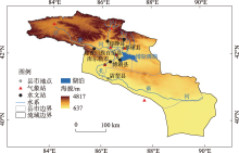
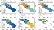
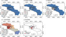
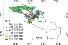
周璟, 王宏卫, 谈波, 等. 开都河流域生态安全格局构建与生态修复分区识别[J]. 生态学报, 2022, 42(24): 10127-10137.
|
|
[Zhou Jing, Wang Hongwei, Tan Bo, et al. Construction of ecological security pattern and identification of ecological restoration zones in the Kaidu River Basin[J] Acta Ecologica Sinica, 2022, 42(24): 10127-10137. ]
|
 ),李建贵2(