Arid Zone Research ›› 2024, Vol. 41 ›› Issue (1): 157-168.doi: 10.13866/j.azr.2024.01.15
• Ecology and Environment • Previous Articles Next Articles
YAO Jinxi1,2( ),XIAO Chengzhi3,ZHANG Zhi3(),WANG Lang4,ZHANG Kun2
Received:2023-02-14
Revised:2023-08-17
Online:2024-01-15
Published:2024-01-24
YAO Jinxi, XIAO Chengzhi, ZHANG Zhi, WANG Lang, ZHANG Kun. Vegetation feature type extraction in arid regions based on GEE multi-source remote sensing data[J].Arid Zone Research, 2024, 41(1): 157-168.
Add to citation manager EndNote|Reference Manager|ProCite|BibTeX|RefWorks

Fig. 1
Study area image map and sample selection"

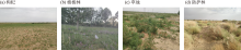
Fig. 2
Field photographs of the main vegetation types in the study area"


Fig. 3
Technical flow chart"

Tab. 1
Feature space description"
| 特征变量 | 简写 | 特征说明 |
|---|---|---|
| 光谱特征 | B | B2~B8、B8A、B9、B11、B12 |
| NDVI | (B8A-B4)/(B8A+B4) | |
| EVI | 2.5×(B8A-B4)/(B8A+6×B4-7.5×B2+1) | |
| GNDVI | (B8A-B3)/(B8A+B3) | |
| NDVIre1 | (B8A-B5)/(B8A+B5) | |
| NDVIre2 | (B8A-B6)/(B8A+B6) | |
| NDVIre3 | (B8A-B7)/(B8A+B7) | |
| NDre1 | (B6-B5)/(B6+B5) | |
| NDre2 | (B7-B5)/(B7+B5) | |
| CIre | B7/B5-1 | |
| 纹理特征 | Gray_asm | 角二阶矩 |
| Gray_contrast | 对比度 | |
| Gray_corr | 相关性 | |
| Gray_ent | 熵 | |
| Gray_var | 方差 | |
| Gray_idm | 逆差矩 | |
| Gray_savg | 总和平均值 | |
| 雷达特征 | VV | VV极化后向散射系数 |
| VH | VH极化后向散射系数 |

Fig. 4
Spectral and texture characteristics of different features"

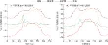
Fig. 5
Overlaid radar polarization feature time series feature"

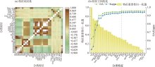
Fig. 6
Classification feature correlation and optimization analysis"

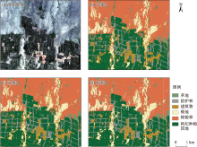
Fig. 7
Three classification schemes the results"

Tab. 2
The accuracy statistics of three classification schemes"
| 类别 | 草地 | 防护林 | 建筑物 | 裸地 | 梭梭林 | 枸杞种植园地 | 总体精度/% | Kappa系数 | |
|---|---|---|---|---|---|---|---|---|---|
| 方案1 | UA/% | 90.41 | 93.12 | 94.71 | 87.23 | 83.84 | 90.75 | 91.42 | 0.8865 |
| PA/% | 74.16 | 85.49 | 97.39 | 85.60 | 93.96 | 89.53 | |||
| 方案2 | UA/% | 75.79 | 97.05 | 93.72 | 85.60 | 86.96 | 96.12 | 93.21 | 0.9105 |
| PA/% | 80.90 | 94.18 | 95.86 | 87.20 | 95.76 | 90.47 | |||
| 方案3 | UA/% | 93.67 | 97.86 | 96.34 | 88.60 | 90.48 | 97.04 | 95.51 | 0.9406 |
| PA/% | 83.15 | 94.87 | 97.44 | 91.20 | 96.08 | 95.14 | |||
Tab. 3
The classification optimization accuracy of the three schemes"
| 类别 | 草地 | 防护林 | 建筑物 | 裸地 | 梭梭林 | 枸杞种植园地 | 总体精度/% | Kappa系数 | |
|---|---|---|---|---|---|---|---|---|---|
| 优化1 | UA/% | 96.00 | 96.58 | 96.27 | 87.47 | 90.42 | 97.17 | 95.23 | 0.9370 |
| PA/% | 80.90 | 94.67 | 97.01 | 91.20 | 95.43 | 95.20 | |||
| 优化2 | UA/% | 95.06 | 97.28 | 96.46 | 89.03 | 91.21 | 98.14 | 95.89 | 0.9457 |
| PA/% | 84.62 | 95.74 | 97.72 | 90.69 | 95.72 | 95.82 | |||
| 优化3 | UA/% | 93.33 | 99.05 | 98.27 | 91.25 | 90.65 | 95.12 | 96.06 | 0.9479 |
| PA/% | 78.65 | 92.40 | 99.07 | 91.73 | 94.94 | 97.43 | |||
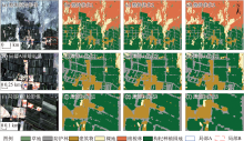
Fig. 8
Three categories to optimize theoverall and local results"

| [1] |
Zhang P, Hu S, Li W, et al. Improving parcel-level mapping of smallholder crops from vhsr imagery: An ensemble machine-learning-based framework[J]. Remote Sensing, 2021, 13(11): 2146.
doi: 10.3390/rs13112146 |
| [2] |
Denize J, Hubert-Moy L, Betbeder J, et al. Evaluation of using sentinel-1 and-2 time-series to identify winter land use in agricultural landscapes[J]. Remote Sensing, 2018, 11(1): 37.
doi: 10.3390/rs11010037 |
| [3] |
Xiao X, Boles S, Frolking S, et al. Mapping paddy rice agriculture in South and Southeast Asia using multi-temporal MODIS images[J]. Remote Sensing of Environment, 2006, 100(1): 95-113.
doi: 10.1016/j.rse.2005.10.004 |
| [4] | 王文静, 张霞, 赵银娣, 等. 综合多特征的Landsat 8时序遥感图像棉花分类方法[J]. 遥感学报, 2017, 21(1): 115-124. |
| [Wang Wengjing, Zhang Xia, Zhao Yindi, et al. Cotton extraction method of integrated multi-features based on multi-temporal Landsat 8 images[J]. Journal of Remote Sensing, 2017, 21(1): 115-124.] | |
| [5] |
Zhang H, Du H, Zhang C, et al. An automated early-season method to map winter wheat using time-series Sentinel-2 data: A case study of Shandong, China[J]. Computers and Electronics in Agriculture, 2021, 182: 105962.
doi: 10.1016/j.compag.2020.105962 |
| [6] | 王德军, 姜琦刚, 李远华, 等. 基于Sentinel-2A/B时序数据与随机森林算法的农耕区土地利用分类[J]. 国土资源遥感, 2020, 32(4): 236-243. |
| [Wang Dejun, Jiang Qigang, Li Yuanhua, et al. Land use classification of farming areas based on time series Sentinel-2A/B data and random forest algorithm[J]. Remote Sensing for Natural Resources, 2020, 32(4): 236-243.] | |
| [7] | 闵钰魁, 柯樱海, 韩月, 等. 融合Sentinel-2和GF-1时序影像的入侵植物互花米草清除动态监测[J]. 遥感学报, 2023, 27(6): 1467-1479. |
| [Min Yukui, Ke Yinhai, Han Yue, et al. Dynamic monitoring of invasive Spartina alterniflora clearance via fusion of Sentinel-2 and GF-1 time series images[J]. National Remote Sensing Bulletin, 2023, 27(6): 1467-1479.] | |
| [8] |
Fatchurrachman, Rudiyanto, Soh N C, et al. High-resolution mapping of paddy rice extent and growth stages across peninsular malaysia using a fusion of sentinel-1 and 2 time series data in Google Earth Engine[J]. Remote Sensing, 2022, 14(8): 1875.
doi: 10.3390/rs14081875 |
| [9] |
Chakhar A, Hernández-López D, Ballesteros R, et al. Improving the accuracy of multiple algorithms for crop classification by integrating sentinel-1 observations with sentinel-2 data[J]. Remote Sensing, 2021, 13(2): 243.
doi: 10.3390/rs13020243 |
| [10] | 明義森, 刘启航, 柏荷, 等. 利用光学和SAR遥感数据的若尔盖湿地植被分类与变化监测[J]. 遥感学报, 2023, 27(6): 1414-1425. |
| [Ming Yiseng, Liu Qihang, Bai He, et al. Classification and change detection of vegetation in the Ruoergai Wetland using optical and SAR remote sensing data[J]. National Remote Sensing Bulletin, 2023, 27(6): 1414-1425.] | |
| [11] | 张琍, 罗文庭, 张皓寰, 等. 时序Sentinel-1和Sentinel-2 数据支持下的鄱阳湖湿地草本植物群落制图分类[J]. 遥感学报, 2023, 27(6): 1362-1375. |
| [Zhang Li, Luo Wenting, Zhang Haohuan, et al. Classification scheme for mapping wetland herbaceous plant communities using time series Sentinel-1 and Sentinel-2 data[J]. National Remote Sensing Bulletin, 2023, 27(6): 1362-1375.] | |
| [12] | 曹文梅, 刘廷玺, 王喜喜, 等. 科尔沁沙丘草甸相间地区土地利用与覆被识别[J]. 干旱区研究, 2021, 38(2): 526-535. |
| [Cao Wenmei, Liu Tingxi, Wang Xixi, et al. Land use and land cover classifications of Horqin Sandy Land dune-meadow areas[J]. Arid Zone Research, 2021, 38(2): 526-535.] | |
| [13] | 姚金玺, 王浪, 李建忠, 等. 青海诺木洪地区多源遥感及多特征组合地物分类[J]. 农业工程学报, 2022, 38(3): 247-256. |
| [Yao Jinxi, Wang Lang, Li Jianzhong, et al. Multi-source remote sensing and multi-feature combination ground object classification in Nuomuhong areas, Qinghai Province of China[J]. Transactions of the Chinese Society of Agricultural Engineering, 2022, 38(3): 247-256.] | |
| [14] | Awad M. Google Earth Engine (GEE) cloud computing based crop classification using radar, optical images and Support Vector Machine Algorithm (SVM)[C]// IEEE 3rd International Multidisciplinary Conference on Engineering Technology, 2021: 71-76. |
| [15] | Virnodkar S, Pachghare V K, Patil V C, et al. Performance evaluation of RF and SVM for sugarcane classification using Sentinel-2 NDVI time-series[C]// Progress in Advanced Computing and Intelligent Engineering: Proceedings of ICACIE, 2021: 163-174. |
| [16] | Ponganan N, Horanont T, Artlert K, et al. Land Cover Classification using Google Earth Engine’s Object-oriented and Machine Learning Classifier[C]// 2021 2nd International Conference on Big Data Analytics and Practices (IBDAP), IEEE, 2021: 33-37. |
| [17] |
Yao J, Wu J, Xiao C, et al. The classification method study of crops remote sensing with deep learning, machine learning, and Google Earth Engine[J]. Remote Sensing, 2022, 14(12): 2758.
doi: 10.3390/rs14122758 |
| [18] | 梁顺林, 白瑞, 陈晓娜, 等. 2019年中国陆表定量遥感发展综述[J]. 遥感学报, 2020, 24 (6): 618-671. |
| [Liang Shunlin, Bai Rui, Chen Xiaona, et al. Review of China’s land surface quantitative remote sensing development in 2019[J]. Journal of Remote Sensing, 2020, 24(6): 618-671.] | |
| [19] |
邱凤婷, 过志峰, 张宗科, 等. 基于改进SVM分类法的SAR图像水体面积提取研究[J]. 地球信息科学学报, 2022, 24(5): 940-948.
doi: 10.12082/dqxxkx.2022.210095 |
|
[Qiu Fengting, Guo Zhifeng, Zhang Zongke, et al. Water body area extraction from SAR image based on improved SVM classification method[J]. Journal of Geo-information Science, 2022, 24(5): 940-948.]
doi: 10.12082/dqxxkx.2022.210095 |
|
| [20] | 庞海威, 余殿, 任成宝, 等. 宁夏东部半干旱区典型植物群落遥感分类特征[J]. 干旱区研究, 2022, 39(6): 1930-1941. |
| [Pang Haiwei, Yu Dian, Ren Chengbao, et al. Remote sensing classification characteristics of typical plant communities in the semi-arid areas of eastern Ningxia[J]. Arid Zone Research, 2022, 39(6): 1930-1941.] | |
| [21] | 杨维涛, 孙建国, 马恒利, 等. 地貌形态多尺度综合分类方法[J]. 干旱区研究, 2022, 39(2): 638-645. |
| [Yang Weitao, Sun Jianguo, Ma Hengli, et al. A multi-scale integrated classification method for landforms[J]. Arid Zone Research, 2022, 39(2): 638-645.] | |
| [22] |
Tassi A, Vizzari M. Object-oriented lulc classification in google earth engine combining snic, glcm, and machine learning algorithms[J]. Remote Sensing, 2020, 12(22): 3776.
doi: 10.3390/rs12223776 |
| [23] | 刘通, 任鸿瑞. GEE平台下利用物候特征进行面向对象的水稻种植分布提取[J]. 农业工程学报, 2022, 38(12): 189-196. |
| [Liu Tong, Ren Hongrui. Object-oriented extraction of paddy rice planting areas using phenological features from the GEE platform[J]. Transactions of the Chinese Society of Agricultural Engineering, 2022, 38(12): 189-196.] | |
| [24] | 肖森天, 依力亚斯江·努尔麦麦提, 努尔比耶·穆合塔尔, 等. 基于光学和雷达多源遥感的于田绿洲土壤盐渍化时空分析[J]. 干旱区研究, 2023, 40(1): 59-68. |
| [Xiao Sentian, Ilyas Nurmemet, Nuerbiye Muhetaer, et al. Spatial and temporal analysis of soil salinity in Yutian Oasis by combined optical and radar multi-source remote sensing[J]. Arid Zone Research, 2023, 40(1): 59-68.] | |
| [25] |
Yang G, Zhao Y, Xing H, et al. Understanding the changes in spatial fairness of urban greenery using time-series remote sensing images: A case study of Guangdong-Hong Kong-Macao Greater Bay[J]. Science of The Total Environment, 2020, 715: 136763.
doi: 10.1016/j.scitotenv.2020.136763 |
| [26] | Achanta R, Susstrunk S. Superpixels and polygons using simple non-iterative clustering[C]// Proceedings of the IEEE Conference on Computer Vision and Pattern Recognition, 2017: 4651-4660. |
| [27] |
穆学青, 郭向阳, 明庆忠, 等. 黄河流域旅游生态安全的动态演变特征及驱动因素[J]. 地理学报, 2022, 77(3): 714-735.
doi: 10.11821/dlxb202203015 |
|
[Mu Xueqing, Guo Xiangyang, Ming Qingzhong, et al. Dynamic evolution characteristics and driving factors of tourism ecological security in the Yellow River Basin[J]. Acta Geographica Sinica, 2022, 77(3): 714-735.]
doi: 10.11821/dlxb202203015 |
|
| [28] |
王振武, 孙佳骏, 于忠义, 等. 基于支持向量机的遥感图像分类研究综述[J]. 计算机科学, 2016, 43(9): 11-17.
doi: 10.11896/j.issn.1002-137X.2016.09.002 |
|
[Wang Zhenwu, Sun Jiajun, Yu Zhongyi, et al. Review of remote sensing image classification based on support vector machine[J]. Computer Science, 2016, 43(9): 11-17.]
doi: 10.11896/j.issn.1002-137X.2016.09.002 |
|
| [29] | 戴声佩, 易小平, 罗红霞, 等. 基于GEE和Landsat时间序列数据的海南岛土地利用分类研究[J]. 热带作物学报, 2021, 42(11): 3351-3357. |
| [Dai Shengpei, Yi Xiaoping, Luo Hongxia, et al. Mapping land use in Hainan Island based on Google Earth Engine and Landsat time series data[J]. Chinese Journal of Tropical Crops, 2021, 42(11): 3351-3357.] | |
| [30] |
宁晓刚, 常文涛, 王浩, 等. 联合GEE与多源遥感数据的黑龙江流域沼泽湿地信息提取[J]. 遥感学报, 2022, 26(2): 386-396.
doi: 10.11834/jrs.20200033 |
|
[Ning Xiaogang, Chang Wentao, Wang Hao, et al. Extraction of marsh wetland in Heilongjiang Basin based on GEE and multi-source remote sensing data[J]. National Remote Sensing Bulletin, 2022, 26(2): 386-396.]
doi: 10.11834/jrs.20200033 |
|
| [31] |
杨泽航, 王文, 鲍健雄. 融合多源遥感数据的黑河中游地区生长季早期作物识别[J]. 地球信息科学学报, 2022, 24(5): 996-1008.
doi: 10.12082/dqxxkx.2022.210527 |
|
[Yang Zehang, Wang Wen, Bao Jianxiong. Identifying crop types in early growing season in the middle reaches of Heihe River by fusing multi-source remote sensing data[J]. Journal of Geo-information Science, 2022, 24(5): 996-1008.]
doi: 10.12082/dqxxkx.2022.210527 |
| [1] | WANG Jun, CHAI Zhifu, MA Haoyan, ZHAO Zhimeng, WU Jiabin, FU Weiping. Land use type interpretation and dynamic changes due to water storage projects using support vector machine [J]. Arid Zone Research, 2024, 41(4): 581-589. |
| [2] | LI Mengfan, ZHENG Jianghua, QIAN Anliang, LI Jiahui, Adiljan PARHAT, WANG Zhe, MA Lisha, WANG Nan. Research on the extraction method of Tianshan glacier lake based on decision tree [J]. Arid Zone Research, 2024, 41(10): 1699-1707. |
| [3] | ZHAO Yuqi, WEI Tianxing. Changes in vegetation cover and influencing factors in typical counties of the Loess Plateau from 1990 to 2020 [J]. Arid Zone Research, 2024, 41(1): 147-156. |
| [4] | LI Xiaoyu, JIA Keli, WEI Huimin, CHEN Ruihua, WANG Yijing. Prediction of soil salt content based on the random forest algorithm [J]. Arid Zone Research, 2023, 40(8): 1258-1267. |
| [5] | JIA Songtao,HUANG Shengzhi,WANG Hao,LI Ziyan,HUANG Qiang,LIANG Hao. Simulation of vegetation change based on BP-SVM mode [J]. Arid Zone Research, 2021, 38(4): 1085-1093. |
| [6] | CHEN Chunxiu,CHEN Shujiang,XU Shiwei,CHEN Mengyu,JIA Xiang,HUANG Tiecheng,LI Chunlei. Crataegus songarica recognition using Gaofen-6 wide-field-view data assisted by multiple features [J]. Arid Zone Research, 2021, 38(2): 553-561. |
|
||