Arid Zone Research ›› 2024, Vol. 41 ›› Issue (4): 581-589.doi: 10.13866/j.azr.2024.04.05
• Land and Water Resources • Previous Articles Next Articles
WANG Jun1,2( ), CHAI Zhifu3, MA Haoyan4, ZHAO Zhimeng4, WU Jiabin1,2, FU Weiping3
Received:2023-08-15
Revised:2024-01-19
Online:2024-04-15
Published:2024-04-26
WANG Jun, CHAI Zhifu, MA Haoyan, ZHAO Zhimeng, WU Jiabin, FU Weiping. Land use type interpretation and dynamic changes due to water storage projects using support vector machine[J].Arid Zone Research, 2024, 41(4): 581-589.
Add to citation manager EndNote|Reference Manager|ProCite|BibTeX|RefWorks

Fig. 1
Location of the study area"

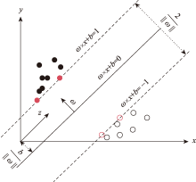
Fig. 2
Principle of support vector machine"
Tab. 1
Data types"
| 数据名称 | 空间分辨率 | 数据格式 | 时段 | 面积范围 | 数据来源 |
|---|---|---|---|---|---|
| TM/ETM | 30 m | .tif | 2000—2020年 | 1501.35 km2 | |
Tab. 2
Land use classification in the study area"
| 一级 | 耕地 | 林地 | 草地 | 水体 | 城乡工矿 | 居民用地 | 未利用土地 | |||
|---|---|---|---|---|---|---|---|---|---|---|
| 二级 | 耕地 | 林地 | 低覆盖度草地 | 中覆盖度草地 | 高覆盖度草地 | 水体 | 建设用地 | 其他建设用地 | 未利用土地 | |
| 代码 | 1 | 2 | 31 | 32 | 33 | 4 | 5 | 6 | 7 | |
Fig. 3
Distribution of sample points in different horizontal years"

Tab. 3
Confusion matrix and evaluation accuracy of classification results in 2000"
| 精度评价样本 | 预测类型及数量 | 评价指标 | ||||||||||||
|---|---|---|---|---|---|---|---|---|---|---|---|---|---|---|
| 类型 | 数量 | 耕地 | 林地 | 草地 | 水体 | 建设 用地 | 其他建设用地 | 未利用 土地 | 用户 精度/% | 生产者 精度/% | 总体分类 精度/% | Kappa 系数 | ||
| 耕地 | 64 | 56 | 8 | 72.7 | 87.5 | 89.4 | 0.87 | |||||||
| 林地 | 23 | 3 | 14 | 5 | 1 | 100.0 | 60.9 | |||||||
| 草地 | 131 | 17 | 109 | 1 | 4 | 81.3 | 83.2 | |||||||
| 水体 | 33 | 33 | 100.0 | 100.0 | ||||||||||
| 建设用地 | 98 | 1 | 1 | 96 | 99.0 | 98.0 | ||||||||
| 其他建设用地 | 98 | 1 | 97 | 100.0 | 99.0 | |||||||||
| 未利用土地 | 45 | 10 | 35 | 87.5 | 77.8 | |||||||||
Tab. 4
Confusion matrix and evaluation accuracy of classification results in 2020"
| 精度评价样本标签 | 预测类型及数量 | 评价指标 | |||||||||||
|---|---|---|---|---|---|---|---|---|---|---|---|---|---|
| 类型 | 数量 | 林地 | 草地 | 水体 | 建设 用地 | 其他建 设用地 | 未利用 土地 | 用户 精度/% | 生产者 精度/% | 总体分类 精度/% | Kappa 系数 | ||
| 耕地 | 58 | 2 | 6 | 1 | 3 | 1 | 93.8 | 77.6 | 94.2 | 0.93 | |||
| 林地 | 38 | 36 | 2 | 94.7 | 94.7 | ||||||||
| 草地 | 76 | 66 | 3 | 4 | 89.2 | 86.8 | |||||||
| 水体 | 49 | 49 | 98.0 | 100.0 | |||||||||
| 建设用地 | 96 | 96 | 96.0 | 100.0 | |||||||||
| 其他建设用地 | 98 | 1 | 97 | 97.0 | 99.0 | ||||||||
| 未利用土地 | 35 | 35 | 87.5 | 100.0 | |||||||||
Tab. 5
Landuse type change before and after water storage project construction /km2"
| 年份 | 耕地 | 林地 | 低覆盖 度草地 | 中覆盖 度草地 | 高覆盖 度草地 | 水体 | 建设 用地 | 其他建 设用地 | 未利用 土地 |
|---|---|---|---|---|---|---|---|---|---|
| 2000年 | 166.6 | 4.2 | 638.9 | 484.0 | 129.3 | 38.7 | 21.7 | 5.6 | 12.4 |
| 2002年 | 166.7 | 5.2 | 89.5 | 268.7 | 905.1 | 26.4 | 24.3 | 5.6 | 10.0 |
| 2004年 | 172.3 | 6.4 | 133.7 | 401.4 | 721.3 | 25.4 | 24.4 | 6.9 | 9.5 |
| 2006年 | 183.3 | 7.0 | 233.6 | 601.2 | 405.0 | 28.1 | 25.5 | 9.5 | 8.2 |
| 2008年 | 187.5 | 7.8 | 383.4 | 520.5 | 326.7 | 27.8 | 27.9 | 10.1 | 9.7 |
| 2010年 | 196.6 | 8.1 | 724.8 | 366.8 | 132.7 | 21.5 | 29.6 | 11.4 | 9.8 |
| 2012年 | 190.0 | 9.1 | 169.2 | 657.7 | 407.0 | 23.1 | 30.1 | 11.4 | 3.7 |
| 2014年 | 193.1 | 12.5 | 333.0 | 667.9 | 219.2 | 30.8 | 32.5 | 10.9 | 1.4 |
| 2016年 | 190.9 | 13.1 | 483.2 | 594.6 | 141.2 | 29.4 | 34.5 | 13.3 | 1.1 |
| 2018年 | 188.4 | 20.3 | 547.1 | 525.8 | 140.4 | 30.0 | 34.5 | 13.4 | 1.4 |
| 2020年 | 181.7 | 23.7 | 308.9 | 659.1 | 242.5 | 27.2 | 38.1 | 13.5 | 6.7 |
| 2000—2010年 | 178.8 | 6.5 | 367.3 | 440.4 | 436.7 | 28.0 | 25.6 | 8.2 | 10.0 |
| 2010—2020年 | 190.1 | 14.5 | 427.7 | 578.7 | 213.8 | 27.0 | 33.2 | 12.3 | 4.0 |
Fig. 4
Change of land use type area before and after project construction"

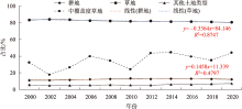
Fig. 5
Changes of area proportion of typical ground object type"
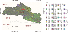
Fig. 6
Spatial transfer distribution of different landuse types from 2000 to 2020"

Tab. 6
Landuse state transfer matrix from 2000 to 2020 /km2"
| 转移方向 | 2020年 | ||||||||||
|---|---|---|---|---|---|---|---|---|---|---|---|
| 耕地 | 林地 | 低覆盖 度草地 | 中覆盖 度草地 | 高覆盖 度草地 | 水体 | 建设 用地 | 其他建 设用地 | 未利用 土地 | 总计 | ||
| 2000年 | 耕地 | 121.5 | 6.5 | 1.6 | 9.9 | 8.6 | 8.0 | 8.6 | 1.9 | 0.0 | 166.6 |
| 林地 | 0.1 | 2.7 | 0.0 | 0.3 | 1.1 | 0.0 | 0.0 | 0.0 | 0.0 | 4.2 | |
| 低覆盖度草地 | 29.2 | 3.6 | 184.3 | 333.9 | 73.2 | 1.9 | 6.2 | 4.2 | 2.4 | 638.9 | |
| 中覆盖度草地 | 19.0 | 5.1 | 101.6 | 266.6 | 80.1 | 1.5 | 4.0 | 3.0 | 3.2 | 484.0 | |
| 高覆盖度草地 | 3.8 | 4.5 | 8.2 | 40.0 | 70.1 | 1.9 | 0.2 | 0.2 | 0.3 | 129.3 | |
| 水体 | 5.3 | 1.2 | 5.6 | 4.3 | 8.3 | 13.3 | 0.1 | 0.1 | 0.6 | 38.7 | |
| 建设用地 | 2.4 | 0.0 | 0.1 | 0.2 | 0.3 | 0.1 | 18.6 | 0.0 | 0.0 | 21.7 | |
| 其他建设用地 | 0.4 | 0.0 | 0.1 | 0.3 | 0.1 | 0.2 | 0.4 | 4.1 | 0.0 | 5.6 | |
| 未利用土地 | 0.0 | 0.0 | 7.4 | 3.6 | 0.8 | 0.3 | 0.0 | 0.0 | 0.2 | 12.4 | |
| 总计 | 181.7 | 23.7 | 308.9 | 659.1 | 242.5 | 27.2 | 38.1 | 13.5 | 6.7 | 1501.4 | |
| [1] | 董增川, 梁忠民, 李大勇, 等. 三峡工程对鄱阳湖水资源生态效应的影响[J]. 河海大学学报(自然科学版), 2012, 40(1): 13-18. |
| [Dong Zengchuan, Liang Zhongmin, Li Dayong, et al. Influences of Three Gorges Project on water resources and ecological effects in Poyang Lake[J]. Journal of Hohai University (Natural Sciences), 2012, 40(1): 13-18.] | |
| [2] | 康艳, 高轩, 李伶杰, 等. 供水水库群蓄供水次序与调度图双层优化研究[J]. 水利学报, 2022, 53(10): 1240-1250. |
| [Kang Yan, Gao Xuan, Li Lingjie, et al. A bilayer optimization method of water storing-supplying sequence and operation diagram for water supply reservoir group[J]. Journal of Hydraulic Engineering, 2022, 53(10): 1240-1250.] | |
| [3] | 花顶, 胡实, 莫兴国. 水利工程对年楚河流域农业水资源利用效率和作物生产力的影响[J]. 农业工程学报, 2022, 38(14): 98-107. |
| [Hua Ding, Hu Shi, Mo Xingguo. Impacts of water conservancy projects on agricultural water use efficiency and crop productivity in the Nianchu River Basin of China[J]. Transactions of the Chinese Society of Agricultural Engineering, 2022, 38(14): 98-107.] | |
| [4] | 党池恒. 气候变化下泾河流域径流模拟及水库调度风险研究[D]. 西安: 长安大学, 2021. |
| [Dang Chiheng. Runoff Simulation and Risk Assessment on Reservoir Operation in the Jing River Basin Under Climate Change[D]. Xi’an: Chang’an University, 2021.] | |
| [5] | 胡长通, 杨涛, 万旭昊, 等. 西安市河流沉积物重金属分布特征及其与土地利用类型关系[J]. 干旱区研究, 2022, 39(4): 1270-1281. |
| [Hu Changtong, Yang Tao, Wan Xuhao, et al. Distribution characteristics of heavy metals in river sediments and their relationship with land use types in Xi’an City[J]. Arid Zone Research, 2022, 39(4): 1270-1281.] | |
| [6] | 马瑶瑶, 史培军, 徐伟, 等. 干旱区水电站建设运营生态环境影响遥感监测[J]. 干旱区研究, 2023, 40(9): 1498-1508. |
| [Ma Yaoyao, Shi Peijun, Xu Wei, et al. Remote sensing monitoring of the ecological environment of hydropower station construction and operation in arid areas[J]. Arid Zone Research, 2023, 40(9): 1498-1508.] | |
| [7] | 苏迎庆, 张恩月, 刘源, 等. 汾河流域土地利用变化及生态环境效应[J]. 干旱区研究, 2022, 39(3): 968-977. |
| [Su Yingqing, Zhang Enyue, Liu Yuan, et al. Land-use change and ecological environment effects on Fenhe River Basin[J]. Arid Zone Research, 2022, 39(3): 968-977.] | |
| [8] | 袁静文, 武辰, 杜博, 等. 高分五号高光谱遥感影像的城市土地利用景观格局分析[J]. 遥感学报, 2020, 24(4): 465-478. |
| [Yuan Jingwen, Wu Chen, Du Bo, et al. Analysis of landscape pattern on urban land use based on GF-5 hyperspectral data[J]. Journal of Remote Sensing, 2020, 24(4): 465-478.] | |
| [9] | 骆剑承, 胡晓东, 吴田军, 等. 高分遥感驱动的精准土地利用与土地覆盖变化信息智能计算模型与方法研究[J]. 遥感学报, 2021, 25(7): 1351-1373. |
|
[Luo Jiancheng, Hu Xiaodong, Wu Tianjun, et al. Research on intelligent calculation model and method of precision land use/cover change information driven by high-resolution remote sensin[J]. National Remote Sensing Bulletin, 2021, 25(7): 1351-1373.]
doi: 10.11834/jrs.20219402 |
|
| [10] | 冯权泷, 牛博文, 朱德海, 等. 土地利用/覆被深度学习遥感分类研究综述[J]. 农业机械学报, 2022, 53(3): 1-17. |
| [Feng Quanlong, Niu Bowen, Zhu Dehai, et al. Review for deep learning in land use and land cover remote sensing classification[J]. Transactions of the Chinese Society for Agricultural Machinery, 2022, 53(3): 1-17.] | |
| [11] | 周珂, 杨永清, 张俨娜, 等. 光学遥感影像土地利用分类方法综述[J]. 科学技术与工程, 2021, 21(32): 13603-13613. |
| [Zhou Ke, Yang Yongqing, Zhang Yanna, et al. Review of land use classification methods based on optical remote sensing images[J]. Science Technology and Engineering, 2021, 21(32): 13603-13613.] | |
| [12] | 张银辉, 赵庚星. 土地利用/土地覆盖遥感分类方法的研究综述[J]. 中国农业资源与区划, 2002(3): 21-25. |
| [Zhang Yinhui, Zhao Gengxing. Classification methods of land use/cover based on remote sensing technologies[J]. Journal of China Agricultural Resources and Regional Planning, 2002(3): 21-25.] | |
| [13] | 任海娟, 董建军, 李晓媛, 等. 利用多时相Landsat8图像提取苜蓿人工草地信息[J]. 中国草地学报, 2015, 37(2): 81-87, 120. |
| [Ren Haijuan, Dong Jianjun, Li Xiaoyuan, et al. Extraction artificial alfalfa grassland information using Landsat8 remote sensing data[J]. Chinese Journal of Grassland, 2015, 37(2): 81-87, 120. ] | |
| [14] |
王胜利, 张连蓬, 朱寿红, 等. 多共性特征联合的Landsat8 OLI遥感影像光伏电站提取[J]. 测绘通报, 2018(11): 46-52.
doi: 10.13474/j.cnki.11-2246.2018.0348 |
|
[Wang Shengli, Zhang Lianpeng, Zhu Shouhong, et al. Multi-invariant feature combined photovoltaic power plants extraction using multi-temporal Landsat8 OLI imagery[J]. Bulletin of Surveying and Mapping, 2018(11): 46-52.]
doi: 10.13474/j.cnki.11-2246.2018.0348 |
|
| [15] |
李道纪, 郭海涛, 卢俊, 等. 遥感影像地物分类多注意力融和U型网络法[J]. 测绘学报, 2020, 49(8): 1051-1064.
doi: 10.11947/j.AGCS.2020.20190407 |
| [Li Daoji, Guo Haitao, Lu Jun, et al. A remote sensing image classification procedure based on multilevel attention fusion U-Net[J]. Acta Geodaetica et Cartographica Sinica, 2019, 49(8): 1051-1064.] | |
| [16] | Auria L, Moro R A. Support Vector Machines (SVM) as a Technique for Solvency Analysis[M]. Berlin: Social Science Electronic Publishing, 2008. |
| [17] |
Cervantes J, Garcia-Lamont F, Rodríguez-Mazahua L, et al. A comprehensive survey on support vector machine classification: Applications, challenges and trends[J]. Neurocomputing, 2020, 408: 189-215.
doi: 10.1016/j.neucom.2019.10.118 |
| [18] |
Thamaga K H, Dube T, Shoko C. Evaluating the impact of land use and land cover change on unprotected wetland ecosystems in the arid-tropical areas of South Africa using the Landsat dataset and support vector machine[J]. Geocarto International, 2022, 37(25): 10344-10365.
doi: 10.1080/10106049.2022.2034986 |
| [19] | 林楠, 姜琦刚, 杨佳佳, 等. 基于资源一号02C高分辨率数据的农业区土地利用分类[J]. 农业机械学报, 2015, 46(1): 278-284. |
| [Lin Nan, Jiang Qigang, Yang Jiajia, et al. Classifications of agricultural land use based on high-spatial resolution ZY1-02C remote sensing images[J]. Transactions of the Chinese Society for Agricultural Machinery, 2015, 46(1): 278-284.] | |
| [20] | 刘志刚. 支撑向量机在光谱遥感影像分类中的若干问题研究[D]. 武汉: 武汉大学, 2004. |
| [Liu Zhigang. Key Problems of Applying Support Vector Machines to the Classification of Spectral Remote Sensing Imagery[D]. Wuhan: Wuhan University, 2004.] | |
| [21] |
Cherkassky V, Ma Y. Practical selection of SVM parameters and noise estimation for SVM regression[J]. Neural Networks, 2004, 17(1): 113-126.
pmid: 14690712 |
| [22] | 韩文霆, 郭聪聪, 张立元, 等. 基于无人机遥感的灌区土地利用与覆被分类方法[J]. 农业机械学报, 2016, 47(11): 270-277. |
| [Han Wenting, Guo Congcong, Zhang Liyuan, et al. Classification method of land cover and irrigated farm land use based on UAV remote sensing in irrigation[J]. Transactions of the Chinese Society for Agricultural Machinery, 2016, 47(11): 270-277.] | |
| [23] |
Yang Q, Li X, Shi X. Cellular automata for simulating land use changes based on support vector machines[J]. Computers & Geosciences, 2008, 34(6): 592-602.
doi: 10.1016/j.cageo.2007.08.003 |
| [24] | 李珍珍. 东北地区土地利用变化对其生态系统服务影响研究[D]. 哈尔滨: 黑龙江大学, 2023. |
| [Li Zhenzhen. Study on the Impact of Land Use Change on Ecosystem Services in Northeast China[D]. Harbin: Heilongjiang University, 2023.] | |
| [25] | 道日娜. 气候与土地利用变化对三北地区植被NDVI的影响研究[D]. 呼和浩特: 内蒙古师范大学, 2019. |
| [Dao Rina. Effects of Climate and Land Use Change on Vegetation NDVI in the Three North Region[D]. Hohhot: Inner Mongolia Normal University, 2019.] | |
| [26] | 李世东, 冯德乾. 世界著名生态工程——中国“三北防护林体系建设工程”[J]. 浙江林业, 2021(9): 9-11. |
| [Li Shidong, Feng Deqian. World famous ecological project: China’s “Three-North Shelterbelt system Construction Project”[J]. Zhejiang Forestry, 2021(9): 9-11.] |
| [1] | DONG Pengbei, REN Zongping, LI Peng, WANG Kaibo, HE Guokai, WANG Pu. Ecosystem services trade-offs and synergies drived by landuse changes in Ningxia [J]. Arid Zone Research, 2024, 41(6): 1032-1044. |
| [2] | YAO Jinxi, XIAO Chengzhi, ZHANG Zhi, WANG Lang, ZHANG Kun. Vegetation feature type extraction in arid regions based on GEE multi-source remote sensing data [J]. Arid Zone Research, 2024, 41(1): 157-168. |
| [3] | JIA Songtao,HUANG Shengzhi,WANG Hao,LI Ziyan,HUANG Qiang,LIANG Hao. Simulation of vegetation change based on BP-SVM mode [J]. Arid Zone Research, 2021, 38(4): 1085-1093. |
|
||