Arid Zone Research ›› 2025, Vol. 42 ›› Issue (7): 1196-1210.doi: 10.13866/j.azr.2025.07.04
• Land and Water Resources • Previous Articles Next Articles
LU Li1,2( ), GUO Jianhua3(), WANG Younian4
Received:2024-08-11
Revised:2025-03-28
Online:2025-07-15
Published:2025-07-07
Contact:
GUO Jianhua
E-mail:luli0401@sina.com;guojianhuahkzx@126.com
LU Li, GUO Jianhua, WANG Younian. Depth on soil water-salt transport in arid regions: A case study of representative farmland in the riparian zone of lower Aksu River[J].Arid Zone Research, 2025, 42(7): 1196-1210.
Add to citation manager EndNote|Reference Manager|ProCite|BibTeX|RefWorks
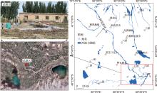
Fig. 1
Map of the study area and experimental site location"

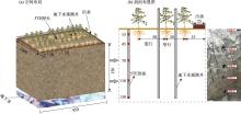
Fig. 2
Schematic diagram of cotton planting method and arrangement of sensors and groundwater observation"

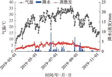
Fig. 3
Rainfall, daily average temperature, and reference crop evapotranspiration during cotton growing season"

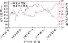
Fig. 4
Variation of groundwater depth and water quality in the experimental area"

Tab. 1
Basic physical properties of soil and VG parameter table"
| 深度/m | 土壤物理特性 | VG参数 | |||||||
|---|---|---|---|---|---|---|---|---|---|
| 砂粒/% | 粉粒/% | 黏粒/% | α | n | |||||
| 0~0.35 | 74.65 | 23.63 | 1.72 | 90.62 | 0.029 | 0.398 | 0.047 | 1.549 | |
| 0.35~0.8 | 65.82 | 30.26 | 3.92 | 66.11 | 0.03 | 0.396 | 0.035 | 1.422 | |
| 0.8~1.8 | 88.58 | 10.96 | 0.46 | 304.76 | 0.039 | 0.389 | 0.044 | 2.542 | |
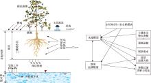
Fig. 5
Schematic diagram of the HYDRUS-1D simulation process"
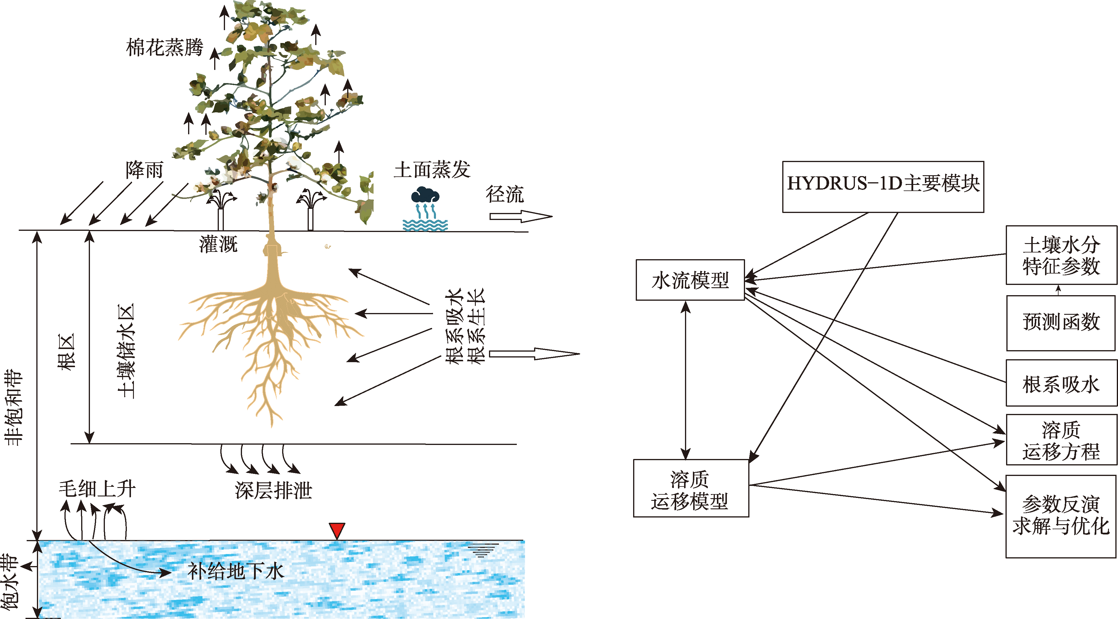
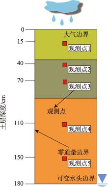
Fig. 6
Hydrogeological conceptual model"

Fig. 7
Comparison of simulation accuracy of moisture content and TDS at different soil depths"

Tab. 2
Table for accuracy verification of simulated soil moisture content and TDS at different soil depths"
| 拟合参数 | 含水率 | 浓度 | |||
|---|---|---|---|---|---|
| 评价指标 | RMSE | NSE | RMSE | NSE | |
| 15 cm | 0.07 | 0.682 | 0.105 | 0.798 | |
| 30 cm | 0.034 | 0.565 | 0.038 | 0.573 | |
| 70 cm | 0.02 | 0.529 | 0.008 | 0.494 | |
| 110 cm | 0.007 | 0.459 | 0.016 | 0.361 | |
| 150 cm | 0.004 | 0.351 | 0.019 | 0.322 | |
| 总体 | 0.033 | 0.862 | 0.008 | 0.752 | |
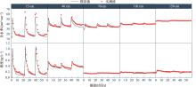
Fig. 8
Fitting results of observed and simulated soil moisture content and concentration at different depths"

Tab. 3
Corrected soil hydraulic parameters and solute transport parameters"
| 深度/m | 土壤类型 | α | n | |||||
|---|---|---|---|---|---|---|---|---|
| 0~0.35 | 粉砂土 | 0.046 | 0.525 | 0.032 | 1.686 | 83.419 | 0.34 | 16.3 |
| 0.35~0.8 | 壤土 | 0.021 | 0.546 | 0.075 | 1.288 | 53.801 | 0.34 | 14.9 |
| 0.8~1.8 | 细砂 | 0.060 | 0.457 | 0.037 | 2.281 | 169.720 | 0.34 | 27.2 |
Tab. 4
Balance of numerical simulation of soil moisture"
| 水分 补给项 | 补给水量/mm | 比值/% | 水分 排泄项 | 排泄水 量/mm | 比值/% |
|---|---|---|---|---|---|
| 灌溉水量+降雨量 | 1269.40 | 85.66 | 作物蒸腾 | 333.05 | 24.75 |
| 潜水补给 | 212.42 | 14.34 | 潜水蒸发 | 209.56 | 15.58 |
| 底边界排泄 | 802.94 | 59.67 | |||
| 合计 | 1481.82 | 100 | 合计 | 1345.55 | 100 |
Tab. 5
Soil salinity numerical simulation equilibrium"
| 月份 | 进盐量 | 排盐量 | 补给量 | 积盐量 | 总进盐量 | 总排盐量 | 总积盐量 | 脱盐率/% |
|---|---|---|---|---|---|---|---|---|
| /(mg·cm-2) | ||||||||
| 3 | 31.44 | 44.258 | 35.581 | 22.763 | 199.99 | -267.78 | -67.79 | 33.89 |
| 4 | 31.44 | 52.474 | 3.096 | -17.938 | ||||
| 5 | 31.44 | 95.091 | 1.519 | -62.132 | ||||
| 6 | 0 | 21.83 | 0.69 | -21.14 | ||||
| 7 | 32.844 | 52.38 | 8.56 | -10.976 | ||||
| 8 | 0 | 1.75 | 9.34 | 7.59 | ||||
| 9 | 0 | 0 | 14.04 | 14.04 |
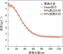
Fig. 9
Variation of soil salinity in the root zone under different irrigation levels"

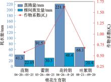
Fig. 10
Statistics of evapotranspiration during crop growth in the study area"

Tab. 6
Optimization of irrigation system for cotton in farmland"
| 棉花生育期 | 灌溉日期/月-日 | 灌溉量/mm |
|---|---|---|
| 春灌 | 03-10—03-25 | 156.85 |
| 苗期 | 04-20—04-30 | 63.35 |
| 蕾期 | 05-25—05-30 | 121.8 |
| 花期 | 06-25—06-30 | 269.5 |
| 吐絮期 | 08-20—08-25 | 88.5 |
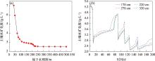
Fig. 11
Relationship between soil salinity in the root zone and groundwater depth"

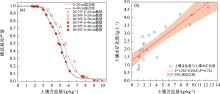
Fig. 12
Relationship between soil salinity in the root zone and groundwater depth"

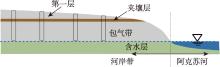
Fig. 13
Schematic diagram of the Aksu River riparian zone"
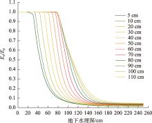
Fig. 14
Variation of actual evaporation and stable evaporation depth with groundwater depth under the control of the soil layer position"

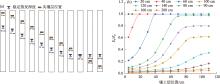
Fig. 15
Relationship between stable evaporation depth and the position of the interlayer (a), The influence of interlayer position on the ratio of actual evapotranspiration (Ea) to potential evaporation (Ep) under different water level conditions (b)"
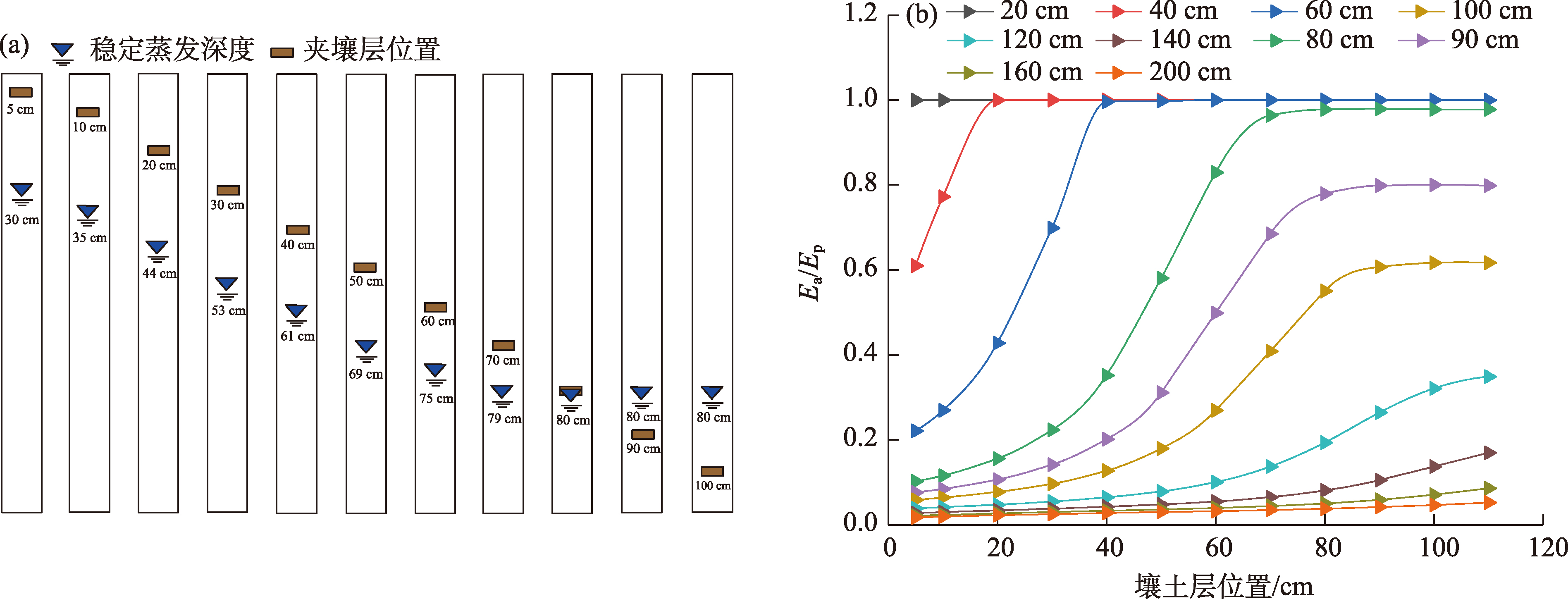
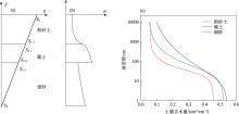
Fig. 16
Distribution of suction (S) and water content (θ) in layered soil during stable evaporation"

| [1] |
鲁力, 葛燕燕, 李升, 等. 新疆阿克苏河流域高砷地下水化学特征及富集成因[J]. 干旱区研究, 2025, 42(2): 258-273.
doi: 10.13866/j.azr.2025.02.07 |
| [Lu Li, Ge Yanyan, Li Sheng, et al. Hydrochemical characteristies and enrichment mechanisms of high-arsenicgroundwater in the Aksu River Basin, Xinjiang[J]. Arid Zone Research, 2025, 42(2): 258-273.] | |
| [2] | Lei Y, Liu Y, Sun Z, et al. Influences of paleoclimatic environment and hydrogeochemical evolution on groundwater salinity in an arid inland plain in northwestern China[J]. Applied Geochemistry, 2023, 154: 105688. |
| [3] | Lu L, Li S, Wu R, et al. study on the scale effect of spatial variation in soil salinity based on geostatistics: A case study of yingdaya River Irrigation Area[J]. Land, 2022, 11(10): 1697. |
| [4] | Lu L, Li S, Gao Y, et al. Analysis of the characteristics and cause analysis of soil salt space based on the basin scale[J]. Applied Sciences-Basel, 2022, 12(18): 9022. |
| [5] | 朱会义. 土地利用变化的内在动力——新疆地区农业生产要素产出效率的变动趋势分析[J]. 地理学报, 2013, 68(8): 1029-1037. |
| [Zhu Huiyi. Incentive of land use change: A case study on the variations of agricultural factor productivity in Xinjiang[J]. Acta Geographica Sinica, 2013, 68(8): 1029-1037.] | |
| [6] |
Sheng Y, Tian X, Qiao W, et al. Measuring agricultural total factor productivity in China: Pattern and drivers over the period of 1978-2016[J]. Australian Journal of Agricultural and Resource Economics, 2020, 64(1): 82-103.
doi: 10.1111/1467-8489.12327 |
| [7] | Yan W, Li F, Zhao Y. Determination of irrigation water quantity and its impact on crop yield and groundwater[J]. Agricultural Water Management, 2022, 273: 107900. |
| [8] | Feng G, Zhang Z, Wan C, et al. Effects of saline water irrigation on soil salinity and yield of summer maize (Zea mays L.) in subsurface drainage system[J]. Agricultural Water Management, 2017, 193: 205-213. |
| [9] | Wang W, Chen Y, Wang W, et al. Water quality and interaction between groundwater and surface water impacted by agricultural activities in an oasis-desert region[J]. Journal of Hydrology, 2023, 617: 128937. |
| [10] | Foster S, Pulido-Bbosch A, Vallejos A, et al. Impact of irrigated agriculture on groundwater-recharge salinity: A major sustainability concern in semi-arid regions[J]. Hydrogeology Journal, 2018, 26(8): 2781-2791. |
| [11] | Xie T, Liu X, Sun T. The effects of groundwater table and flood irrigation strategies on soil water and salt dynamics and reed water use in the Yellow River Delta, China[J]. Ecological Modelling, 2011, 222(2): 241-252. |
| [12] | Dou X, Shi H, Li R, et al. Simulation and evaluation of soil water and salt transport under controlled subsurface drainage using HYDRUS-2D model[J]. Agricultural Water Management, 2022, 273: 107899. |
| [13] | Guo S, Li X, Šimůnek J, et al. Experimental and numerical evaluation of soil water and salt dynamics in a corn field with shallow saline groundwater and crop-season drip and autumn post-harvest irrigations[J]. Agricultural Water Management, 2024, 305: 109119. |
| [14] | Che Z, Wang J, Li J. Effects of water quality, irrigation amount and nitrogen applied on soil salinity and cotton production under mulched drip irrigation in arid Northwest China[J]. Agricultural Water Management, 2021, 247: 106738. |
| [15] | Wang H, Feng D, Zhang A, et al. Effects of saline water mulched drip irrigation on cotton yield and soil quality in the North China Plain[J]. Agricultural Water Management, 2022, 262: 107405. |
| [16] | Li W, Wang Z, Zhang J, et al. Soil salinity variations and cotton growth under long-term mulched drip irrigation in saline-alkali land of arid oasis[J]. Irrigation Science, 2022, 40(1): 103-113. |
| [17] | Chen S, Mao X, Shang S. Response and contribution of shallow groundwater to soil water/salt budget and crop growth in layered soils[J]. Agricultural Water Management, 2022, 266: 107574. |
| [18] | Xue J, Huo Z, Wang F, et al. Untangling the effects of shallow groundwater and deficit irrigation on irrigation water productivity in arid region: New conceptual model[J]. Science of the Total Environment, 2018, 619: 1170-1182. |
| [19] | Ma Z, Wang W, Zhang Z, et al. Assessing bare-soil evaporation from different water-table depths using lysimeters and a numerical model in the Ordos Basin, China[J]. Hydrogeology Journal, 2019, 27(7): 2707-2718. |
| [20] | Fahle M, Dietrich O. Estimation of evapotranspiration using diurnal groundwater level fluctuations: Comparison of different approaches with groundwater lysimeter data[J]. Water Resources Research, 2014, 50(1): 273-286. |
| [21] | 中国科学院新疆生物土壤沙漠研究所. 新疆土壤及土地资源研究[M]. 北京: 科学出版社, 1991: 1-37. |
| [Xinjiang Institute of Ecology and Geography, Chinese Academy of Sciences. Research on Xinjiang Soil and Land Resources[M]. Beijing: Science Press, 1991: 1-37.] | |
| [22] | 新疆农业农村厅, 新疆土壤普查办公室. 新疆土壤[M]. 北京: 科学出版社, 1996: 151-521. |
| [Xinjiang Agricultural Department, Xinjiang Soil Survey Office. Xinjiang Soil[M]. Beijing: Science Press, 1996: 151-521.] | |
| [23] | Qi L, Fan J, Shao M, et al. Simulation and verification of soil moisture of root distribution functions for alfalfa[J]. Transactions of the Chinese Society of Agricultural Engineering, 2009, 25(4): 24-29. |
| [24] | Hoffman G, Genuchten M. Soil properties and efficient water use: Water management for salinity control[C]// Taylor H, Jordan W, Sinclair T. Limitations to Efficient Water Use in Crop Production. Madison: American Society of Agronomy, Crop Science Society of America, Soil Science Society of America, 1983: 73-85. |
| [25] | Šimůnek J, Suarez D. Modeling of carbon dioxide transport and production in soil 1. Model development[J]. Water Resources Research, 1993, 29: 487-497. |
| [26] |
张立桢, 曹卫星, 张思平, 等. 棉花根系生长和空间分布特征[J]. 植物生态学报, 2005, 29(2): 266-273.
doi: 10.17521/cjpe.2005.0034 |
|
[Zhang Lizhen, Cao Weixing, Zhang Siping, et al. Characterizing root growth and spatial distribution in cotton[J]. Chinese Journal of Plant Ecology, 2005, 29(2): 266-273.]
doi: 10.17521/cjpe.2005.0034 |
|
| [27] | 胡宏昌, 张治, 田富强, 等. 新疆绿洲棉田盐分及作物生长对灌溉方式的响应[J]. 清华大学学报: 自然科学版, 2016, 56(4): 373-380. |
| [Hu Hongchang, Zhang Zhi, Tian Fuqiang, et al. Response of soil salinity and crop growth toirrigation methods in Xinjiang[J]. Journal of Tsinghua University (Science and Technology), 2016, 56(4): 373-380.] | |
| [28] | Belmans C, Wesseling J, Feddes R. Simulation model of a water balance of a cropped soil[J]. Journal of Hydrology, 1983, 63(3-4): 271-286. |
| [29] | Zhang Y, Zhang F, Fan J, et al. Effects of drip irrigation technical parameters on cotton growth, soil moisture and salinity in Southern Xinjiang[J]. Transactions of the Chinese Society of Agricultural Engineering, 2020, 36(24): 107-117. |
| [30] | Feddes R, Kowalik P, Kolinska-Malinka K, et al. Simulation of field water uptake by plants using a soil water dependent root extraction function[J]. Journal of Hydrology, 1976, 31(1-2): 13-26. |
| [31] | Husan Tumarbay, Wu Z, Su L, et al. Numerical simulation of soil water-salt movement on drip irrigation cotton under film[J]. Soils, 2012, 44(4): 665-670. |
| [32] | 刘洪光, 白振涛, 李开明. 基于HYDRUS-2D模型的膜下滴灌暗管排水棉田土壤盐分变化[J]. 农业工程学报, 2021, 37(2): 130-141. |
| [Liu Hongguang, Bai Zhentao, Li Kaiming. Soil salinity changes in cotton field under mulched drip irrigation with subsurface pipes drainage using HYDRUS-2D model[J]. Transactions of the Chinese Society of Agricultural Engineering, 2021, 37(2): 130-141.] | |
| [33] | Moriasi D, Arnold J, Van L, et al. Model evaluation guidelines for systematic quantification of accuracy in watershed simulations[J]. Transactions of the Asabe, 2007, 50(3): 885-900. |
| [34] | 王璐. 阿克苏河流域盐渍化区包气带水盐运移规律及潜水位动态调控研究[D]. 乌鲁木齐: 新疆大学, 2020. |
| [Wang Lu. Study on the Law of Water and Salt Migration and Dynamic Regulation of Diving Level in the Vadose Zone in the Salinized Area of the Aksu River Basin[D]. Urumqi: Xinjiang University, 2020.] | |
| [35] | DB65/T 4565-2022. 机采棉主要农艺性状指标要求[S]. 乌鲁木齐: 新疆维吾尔自治区市场监督管理局, 2022. |
| [DB65/T 4565-2022. Requirements for Main Agronomic Traits of Machine-Picked Cotton[S]. Urumqi: Xinjiang Uygur Autonomous Region Market Supervision Administration, 2022.] | |
| [36] | 鲁力, 李升, 高远, 等. 渭-库绿洲土壤盐分空间分布及变异特征[J]. 干旱区资源与环境, 2022, 36(3): 136-142. |
| [Lu Li, Li Sheng, Gao Yuan, et al. Spatial distribution and variation characteristics of soil salinity in the oasis of Weigan and Kuga Rivers[J]. Journal of Arid Land Resources and Environment, 2022, 36(3): 136-142.] | |
| [37] | Toonen W H J, Kleinhans M G, Cohen K M. Sedimentary architecture of abandoned channel fills[J]. Earth Surface Processes and Landforms, 2012, 37(4): 459-472. |
| [38] | 李强, 刘天超, 李通, 等. 新疆阿克苏河流域水文地质环境地质调查报告[R]. 乌鲁木齐: 新疆方圆地质矿产勘查院(有限公司), 2019. |
| [Li Qiang, Liu Tianchao, Li Tong, et al. Hydrogeological and Environmental Geological Survey Report of Aksu River Basin in Xinjiang[R]. Urumqi: Xinjiang Fangyuan Geological and Mineral Exploration Institute (Co., Ltd.), 2019.] | |
| [39] | 李艳, 胡顺军, 宋郁东. 渭干河灌区潜水蒸发规律实验分析[J]. 干旱区资源与环境, 2004, 18(3): 92-96. |
| [Li Yan, Hu Shunjun, Song Yudong. Experimental analysis of phreatic evaporation patterns in the Weigan River Irrigation Area[J]. Journal of Arid Land Resources and Environment, 2004, 18(3): 92-96.] | |
| [40] | 来剑斌, 王永平, 蒋庆华, 等. 土壤质地对潜水蒸发的影响[J]. 西北农林科技大学学报(自然科学版), 2003, 31(6): 153-157. |
| [Lai Jianbin, Wang Yongping, Jiang Qinghua, et al. Study on phreatic evaporation under different soil textures[J]. Journal of Northwest A & F University (Natural Science Edition), 2003, 31(6): 153-157.] | |
| [41] | Gong C, Wang W, Zhang Z, et al. Comparison of field methods for estimating evaporation from bare soil using lysimeters in a semi-arid area[J]. Journal of Hydrology, 2020, 590: 125334. |
| [42] | Zhang Z, Wang W, Wang Z, et al. Evaporation from bare ground with different water-table depths based on an in-situ experiment in Ordos Plateau, China[J]. Hydrogeology Journal, 2018, 26(5): 1683-1691. |
| [1] | WANG Yixuan, DENG Xiaohong, FAN Huiwenqing, HAN Jiangzhe, LI Zongxing. Research advances and arid zone applications of coupled models for water resources carrying capacity [J]. Arid Zone Research, 2025, 42(6): 1004-1020. |
| [2] | ZHANG Xiuxia, HAN Lisha, DANG Xinghai, WANG Xiaoxian, LIN Qingrun, DENG Lingzhi, YANG Minghang, ZHANG Xilai. Spatiotemporal changes in vegetation coverage in the arid regions of Northwest China over the past 30 years and their response to climatic factors [J]. Arid Zone Research, 2025, 42(6): 1067-1079. |
| [3] | WANG Yiqi, MAI Wenxuan, ZHANG Wentai, WANG Yanyan, TIAN Changyan. Effect of soil temperature on cotton growth under phosphate fertilizer drip application conditions [J]. Arid Zone Research, 2025, 42(6): 1151-1158. |
| [4] | ZHANG Jianing, ZHANG Jianjun, LAI Zongrui, ZHAO Jiongchang, HU Yawei, LI Yang, WEI Chaoyang. Effects of stand density on soil nutrients and microbial communities in Robinia pseudoacacia plantations [J]. Arid Zone Research, 2025, 42(2): 274-288. |
| [5] | LEI Feiya, LI Xiaoshuang, TAO Ye, YIN Benfeng, RONG Xiaoying, ZHANG Jing, LU Yongxing, GUO Xing, ZHOU Xiaobing, ZHANG Yuanming. Characterization of soil multifunctionality and its determining factors under moss crust cover in the arid regions of Northwest China [J]. Arid Zone Research, 2024, 41(5): 812-820. |
| [6] | ZHANG Ziqi, YANG Lili, HE Xinlin, LI Xiaolong. Effects of the regulation of water-salt-nitrogen on water-salt nutrient transport and yield in drip-irrigated cotton fields [J]. Arid Zone Research, 2024, 41(5): 876-893. |
| [7] | LAI Hongyu, LYU Desheng, ZHU Yan, WANG Zhenhua, WEN Yue, SONG Libing, QI Hao. Effects of biochar application on soil hydrothermal salinity and cotton growth in brackish water drip irrigation cotton field [J]. Arid Zone Research, 2024, 41(2): 326-338. |
| [8] | WANG Ruofan, LIU Yuxin, LI Peigang, TANG Yue, XIE Wei. Phosphorous distribution patterns and release risks in the riparian zone sediments of the Lanzhou section of the Yellow River [J]. Arid Zone Research, 2024, 41(12): 2035-2044. |
| [9] | XIE Yucai, LIU Hao, ZHAO Fengnian, ZHANG Lei, ZHAO Xin, SHI Zhuo, WANG Xingpeng. Effects of irrigation water mineralization and sodium adsorption ratio on the growth and yield of drip-irrigated cotton under film [J]. Arid Zone Research, 2024, 41(12): 2071-2082. |
| [10] | HOU Cong, SHI Haibin, MIAO Qingfeng, HU Zhiyuan, ZHAO Yi, YU Cuicui, YAN Yan, FAN Liquan, ZHANG Tao. Chemical characteristics of groundwater and water-salt transport in different land classes in the Hetao Irrigation District [J]. Arid Zone Research, 2024, 41(11): 1956-1968. |
| [11] | Areziguli ROZI, Mamat SAWUT, HE Xugang, YE Xiaowen. Estimation of cotton leaf chlorophyll content based on combinations of multi-vegetation indices [J]. Arid Zone Research, 2023, 40(11): 1865-1874. |
| [12] | LIU Yanxue, QIAO Changlu. Study on evapotranspiration of cotton field under drip irrigation in oasis of arid region [J]. Arid Zone Research, 2023, 40(1): 152-162. |
| [13] | GUO Xiaowen,LIU Jiawei,ZHENG Zhiyu,MIN Wei. Effects of saline water drip irrigation on soil salt accumulation and cotton growth during the whole growth period [J]. Arid Zone Research, 2022, 39(6): 1952-1965. |
| [14] | ZHANG Hui,ZHANG Kai,CHEN Bing,YANG Chuan,LIU Ping. Effects of different irrigation rates on cotton growth and yield formation in Xinjiang [J]. Arid Zone Research, 2022, 39(6): 1976-1985. |
| [15] | WANG Jiawen,PENG Jie,JI Wenjun,BAI Jianduo,FENG Chunhui,LI Hongyi. Soil pH inversion based on electromagnetic induction data in cotton field of southern Xinjiang [J]. Arid Zone Research, 2022, 39(4): 1293-1302. |
|
||