干旱区研究 ›› 2021, Vol. 38 ›› Issue (4): 1000-1009.doi: 10.13866/j.azr.2021.04.11 cstr: 32277.14.AZR.20210411
许志平1( ),邵天杰1(),张连凯2,邵明玉2,牛俊杰3
收稿日期:2020-11-11
修回日期:2021-04-03
出版日期:2021-07-15
发布日期:2021-08-03
作者简介:许志平(1995-),男,硕士研究生,主要研究方向为环境污染评价与治理. E-mail: 基金资助:
XU Zhiping1(),SHAO Tianjie1(),ZHANG Liankai2,SHAO Mingyu2,NIU Junjie3
Received:2020-11-11
Revised:2021-04-03
Published:2021-07-15
Online:2021-08-03
摘要:
利用LI-8100A土壤碳通量自动测量系统对晋西北黄土丘陵沟壑区清凉寺沟流域地表土壤CO2通量进行测量,探讨了CO2通量时空变化特征、不同土地利用类型下的CO2通量特征以及环境因子对CO2通量的影响,对于晋西北黄土丘陵沟壑区小流域地区地表土壤CO2通量的研究进行补充。结果表明:(1) CO2通量在生长季呈现单峰变化,于日出前后达单日最低值,在16:00—22:00达到单日最高值;在非生长季则呈现不规律变化。(2) 农耕地的CO2通量相较于荒草地以及枣林地的CO2通量要低;不同季节的CO2通量关系为8月CO2通量最大,5月CO2通量次之,11月CO2通量最低。(3) 地表土壤CO2通量与光合有效辐射、大气温度、土壤温度、土壤含水率、土壤有机质、土壤质地等因素密切相关,通过科学的土地利用方式可有效提高土壤的固碳能力。
许志平,邵天杰,张连凯,邵明玉,牛俊杰. 黄土区不同土地利用类型下砂质壤土地表CO2通量变化特征——以清凉寺沟流域为例[J]. 干旱区研究, 2021, 38(4): 1000-1009.
XU Zhiping,SHAO Tianjie,ZHANG Liankai,SHAO Mingyu,NIU Junjie. Study on the change of surface CO2 flux in sandy loamy soil under different land use types: An example from the Qingliangsi ditch watershed[J]. Arid Zone Research, 2021, 38(4): 1000-1009.

图1
清凉寺沟流域地貌示意图"
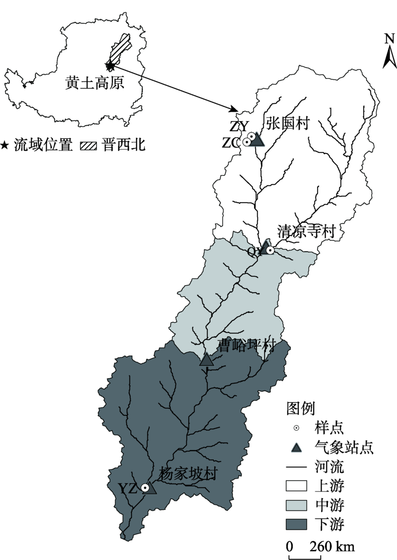

图2
1989—2019年年均降水量及年均气温距平"

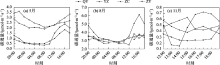
图3
不同季节CO2通量昼夜变化"
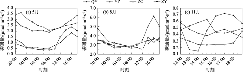

图4
CO2通量与光合有效辐射的关系"

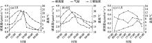
图5
CO2通量与温度的关系"
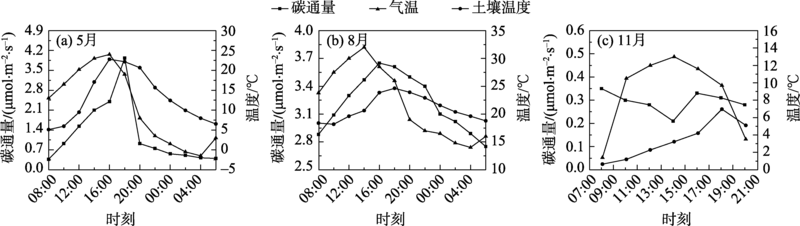
图6
土壤粒径含量分布"
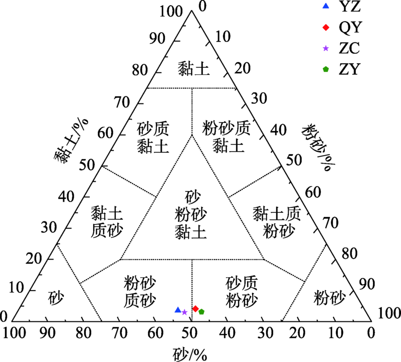
表1
不同季节表层土壤含水率及土壤有机质含量"
| 月份 | 地点 | 土壤含水率/% | 有机质含量/% |
|---|---|---|---|
| 5 | YZ | 6.66 | 9.92 |
| 5 | QY | 10.90 | 8.09 |
| 5 | ZC | 8.84 | 9.42 |
| 5 | ZY | 13.62 | 8.04 |
| 8 | YZ | 15.54 | 11.84 |
| 8 | QY | 5.51 | 8.50 |
| 8 | ZC | 4.65 | 5.02 |
| 8 | ZY | 6.86 | 8.30 |
| 11 | YZ | 12.03 | 8.92 |
| 11 | QY | 12.05 | 11.22 |
| 11 | ZC | 14.24 | 5.59 |
| 11 | ZY | 12.75 | 5.40 |
| [1] | 王春梅, 邵彬, 王汝南. 东北地区两种主要造林树种生态系统固碳潜力[J]. 生态学报, 2010, 30(7):1764-1772. |
| [ Wang Chunmei, Shao Bin, Wang Runan. Carbon sequestration potential of ecosystem of two main tree species in Northeast China[J]. Acta Ecologica Sinica, 2010, 30(7):1764-1772. ] | |
| [2] | 李玉宁, 王关玉, 李伟. 土壤呼吸作用和全球碳循环[J]. 地学前缘, 2002, 9(2):351-357. |
| [ Li Yuning, Wang Guanyu, Li Wei. Soil respiration and carbon cycle[J]. Earth Science Frontiers, 2002, 9(2):351-357. ] | |
| [3] |
Luo H, Oechel W C, Hastings S J, et al. Mature semiarid chaparral ecosystems can be a significant sink for atmospheric carbon dioxide[J]. Global Change Biology, 2007, 13(2):386-396.
doi: 10.1111/gcb.2007.13.issue-2 |
| [4] | 夏彬, 朱世硕, 郝旺林, 等. 黄土丘陵区土壤有机碳含量对侵蚀坡面表层土壤含水量时空变化的影响[J]. 水土保持学报, 2020, 34(3):175-181. |
| [ Xia Bin, Zhu Shishuo, Hao Wanglin, et al. Effects of soil organic carbon content on temporal and spatial changes of surface soil water content on eroded slope in the Loess Hilly Region[J]. Journal of Soil and Water Conservation, 2020, 34(3):175-181. ] | |
| [5] | 闫丽娟, 李广, 吴江琪, 等. 黄土高原4种典型植被对土壤活性有机碳及土壤碳库的影响[J]. 生态学报, 2019, 39(15):5546-5554. |
| [ Yan Lijuan, Li Guang, Wu Jiangqi, et al. Effects of four typical vegetations on soil active organic carbon and soil carbon in Loess Plateau[J]. Acta Ecologica Sinica, 2019, 39(15):5546-5554. ] | |
| [6] |
Ran Lishan, Li Lingyu, Tian Mingyang, et al. Riverine CO2 emissions in the Wuding River catchment on the Loess Plateau: Environmental controls and dam impoundment impact[J]. Journal of Geophysical Research: Biogeosciences, 2017, 122(6):1439-1455.
doi: 10.1002/jgrg.v122.6 |
| [7] | 李欣雨, 夏建国, 鄢广奎, 等. 名山河流域不同土壤类型和土地利用方式下有机碳的分布特征[J]. 水土保持学报, 2017, 31(3):224-230, 238. |
| [ Li Xinyu, Xia Jianguo, Yan Guangkui, et al. Distribution of organic carbon under different soil types and utilization patterns in Mingshan River[J]. Journal of Soil and Water Conservation, 2017, 31(3):224-230, 238. ] | |
| [8] | 张英英, 蔡立群, 武均, 等. 不同耕作措施下陇中黄土高原旱作农田土壤活性有机碳组分及其与酶活性间的关系[J]. 干旱地区农业研究, 2017, 35(1):1-7. |
| [ Zhang Yingying, Cai Liqun, Wu Jun, et al. The relationship between soil labile organic carbon fractions and the enzyme activities under different tillage measures in the Loess Plateau of central Gansu province[J]. Agricultural Research in the Arid Areas, 2017, 35(1):1-7. ] | |
| [9] | 彭文英, 张科利, 杨勤科. 退耕还林对黄土高原地区土壤有机碳影响预测[J]. 地域研究与开发, 2006(3):94-99. |
| [ Peng Wenying, Zhang Keli, Yang Qinke. Forecast of impact of the returning farms to forests on soil organic carbon of Loess Plateau[J]. Areal Research and Development, 2006(3):94-99. ] | |
| [10] | 王剑, 薛东前, 宋永永, 等. 基于农地利用的黄土高原碳排放变化及预测研究[J]. 资源开发与市场, 2018, 34(9):1250-1255. |
| [ Wang Jian, Xue Dongqian, Song Yongyong, et al. Carbon emissions and prediction on loess plateau based on farmland utilization[J]. Resources Development& Market, 2018, 34(9):1250-1255. ] | |
| [11] | 毛琴琴. 退耕还林(草)以来黄土高原地区土壤有机碳库的变化[D]. 西安: 西安科技大学, 2019. |
| [ Mao Qinqin. Changes of Soil Organic Carbon Pool in the Loess Plateau Following the “Grain for Green”[D]. Xi’an: Xi’an University of Science and Technology, 2019. ] | |
| [12] | 刘冠, 李国庆, 李洁, 等. 基于InVEST模型的1999—2016年麻塔流域碳储量变化及空间格局研究[J]. 干旱区研究, 2021, 38(1):267-274. |
| [ Liu Guan, Li Guoqing, Li Jie, et al. Study of carbon stock changes and spatial patterns in the Mahta watershed from 1999-2016 based on the InVEST model[J]. Arid Zone Research, 2021, 38(1):267-274. ] | |
| [13] | 张风霞. 科尔沁沙地农田生态系统土壤呼吸与碳平衡特征[D]. 兰州: 兰州交通大学, 2014. |
| [ Zhang Fengxia. Characteristics of Soil Respiration and Carbon Balance of Agriculture Ecosystem in Horqin Sandy Land[D]. Lanzhou: Lanzhou Jiaotong University, 2014. ] | |
| [14] | 赵娜. 太行山南段低丘区不同土地利用方式土壤碳通量组成及其影响机理[D]. 北京: 中国林业科学研究院, 2014. |
| [ Zhao Na. The Components and Infiuence Mechanism of Soil Carbon Flux under Different Lan Use Types in Hilly Area of Southern Taihang Mountains, China[D]. Beijing: Chinese Academy of Forestry, 2014. ] | |
| [15] | 唐庆兰, 任世奇, 项东云, 等. 尾巨桉萌芽林土壤呼吸变化及其与土壤温度和土壤含水率的关系[J]. 西部林业科学, 2015, 44(2):69-73, 79. |
| [ Tang Qinglan, Ren Shiqi, Xiang Dongyun, et al. Soil respiration variations and their relationships with soil temperature and soil moisture content in Eucalyptus urophylla × E. grandis sprout forest[J]. Journal of West China Forestry Science, 2015, 44(2):69-73, 79. ] | |
| [16] | 范月君, 侯向阳, 石红霄, 等. 气候变暖对草地生态系统碳循环的影响[J]. 草业学报, 2012, 21(3):294-302. |
| [ Fan Yuejun, Hou Xiangyang, Shi Hongxiao, et al. Effect of carbon cycling in grassland ecosystems on climate warming[J]. Acta Prataculturae Sinica, 2012, 21(3):294-302. ] | |
| [17] | 陈栋, 郁红艳, 邹路易, 等. 土壤碳转化对大气CO2升高响应机制研究进展[J]. 核农学报, 2017, 31(8):1656-1663. |
| [ Chen Dong, Yu Hongyan, Zou Luyi, et al. Research progress on soil carbon transformation mechanism responses to elevated atmospheric CO2[J]. Journal of Nuclear Agricultural Sciences, 2017, 31(8):1656-1663. ] | |
| [18] | 卫云燕, 尹华军, 刘庆, 等. 气候变暖背景下森林土壤碳循环研究进展[J]. 应用与环境生物学报, 2009, 15(6):888-894. |
| [ Wei Yunyan, Yin Huajun, Liu Qing, et al. Advance in research of forest carbon cycling under climate warming[J]. Chinese Journal of Applied and Environmental Biology, 2009, 15(6):888-894. ] | |
| [19] | 陈全胜, 李凌浩, 韩兴国, 等. 水分对土壤呼吸的影响及机理[J]. 生态学报, 2003, 23(5):972-978. |
| [ Chen Quansheng, Li Linghao, Han Xingguo, et al. Effects of water content on soil respiration and the mechanisms[J]. Acta Ecologica Sinica, 2003, 23(5):972-978. ] | |
| [20] | 赵亚丽, 薛志伟, 郭海斌, 等. 耕作方式与秸秆还田对土壤呼吸的影响及机理[J]. 农业工程学报, 2014, 30(19):155-165. |
| [ Zhao Yali, Xue Zhiwei, Guo Haibin, et al. Effects of tillage and crop residue management on soil respiration and its mechanism[J]. Transactions of the Chinese Society of Agricultural Engineering, 2014, 30(19):155-165. ] | |
| [21] | 陈书涛, 刘巧辉, 胡正华, 等. 不同土地利用方式下土壤呼吸空间变异的影响因素[J]. 环境科学, 2013, 34(3):1017-1025. |
| [ Chen Shutao, Liu Qiaohui, Hu Zhenghua, et al. Factors influencing the spatial variability in soil respiration under different land use regimes[J]. Environmental Science, 2013, 34(3):1017-1025. ] | |
| [22] | 刘昱, 陈敏鹏, 陈吉宁. 农田生态系统碳循环模型研究进展和展望[J]. 农业工程学报, 2015, 31(3):1-9. |
| [ Liu Yu, Chen Minpeng, Chen Jining. Progress and perspectives in studies on agro-ecosystem carbon cycle model[J]. Transactions of the Chinese Society of Agricultural Engineering, 2015, 31(3):1-9. ] | |
| [23] | 张瑞, 曹华, 王云强, 等. 黄土丘陵沟壑区小流域土壤水分空间变异性及其影响因素[J]. 水土保持研究, 2012, 19(5):52-58. |
| [ Zhang Rui, Cao Hua, Wang Yunqiang, et al. Spatial variability of soil moisture and its influencing factors in small watersheds in loess hilly and gully regions[J]. Research on Soil and Water Conservation, 2012, 19(5):52-58. ] | |
| [24] | Houghton R A, Hackler J L. Sources and sinks of carbon from land-use change in China[J]. Global Biogeochemical Cycles, 2003, 17(2):1034. DOI: 10.1029/2002GB001970. |
| [25] | 赵荣钦, 黄贤金, 刘英, 等. 区域系统碳循环的土地调控机理及政策框架研究[J]. 中国人口·资源与环境, 2014, 24(5):51-56. |
| [ Zhao Rongqin, Huang Xianjin, Liu Ying, et al. Mechanism and policy framework for land regulation of carbon cycle of regional system[J]. China Population, Resources and Environment, 2014, 24(5):51-56. ] | |
| [26] | 马晓哲, 王铮. 土地利用变化对区域碳源汇的影响研究进展[J]. 生态学报, 2015, 35(17):5898-5907. |
| [ Ma Xiaozhe, Wang Zheng. Progress in the study on the impact of land-use change on regional carbon sources and sinks[J]. Acta Ecologica Sinica, 2015, 35(17):5898-5907. ] | |
| [27] | 范连连, 谢继萍, 马健, 等. 准噶尔盆地南缘草本层碳通量及土壤呼吸的变化特征[J]. 生态学杂志, 2013, 32(10):2567-2573. |
| [ Fan Lianlian, Xie Jiping, Ma Jian, et al. Variation characteristics of herb layer carbon flux and soil respiration in southern edge of Jungggar basin, Northwest China[J]. Chinese Journal of Ecology, 2013, 32(10):2567-2573. ] | |
| [28] |
Baldocchi D. FLUXNET: A new tool to study the temporal and spatial variability of ecosystem-scale carbon dioxide, water vapor, and energy flux densities[J]. Bulletin of the American Meteorological Society, 2001, 82(11):2415-2434.
doi: 10.1175/1520-0477(2001)082<2415:FANTTS>2.3.CO;2 |
| [29] | 王妍, 彭镇华, 江泽慧, 等. 长江滩地杨树林生态系统的碳通量特征[J]. 林业科学, 2009, 45(11):156-160. |
| [ Wang Yan, Peng Zhenhua, Jiang Zehui, et al. Characteristics of carbon flux of populus forest in the reaches of Yangtze River in Hunan[J]. Scientia Silvae Sinicae, 2009, 45(11):156-160. ] | |
| [30] | 杨庆朋, 徐明, 刘洪升, 等. 土壤呼吸温度敏感性的影响因素和不确定性[J]. 生态学报, 2011, 31(8):2301-2311. |
| [ Yang Qingpeng, Xu Ming, Liu Hongsheng, et al. Impact factors and uncertainties of the temperature sensitivity of soil respiration[J]. Acta Ecologica Sinica, 2011, 31(8):2301-2311. ] | |
| [31] | 夏雪, 车升国. 陆地生态系统有机碳储量和碳排放的研究进展[J]. 中国农学通报, 2011, 27(29):214-218. |
| [ Xia Xue, Che Shengguo. Advance in organic carbon stock and carbon emission in terrestrial ecosystem[J]. Chinese Agricultural Science Bulletin, 2011, 27(29):214-218. ] | |
| [32] | 陈龙飞, 何志斌, 杜军, 等. 土壤碳循环主要过程对气候变暖响应的研究进展[J]. 草业学报, 2015, 24(11):183-194. |
| [ Chen Longfei, He Zhibin, Du Jun, et al. Response of soil carbon cycling to climate warming: Challenges and perspectives[J]. Acta Prataculturae Sinica, 2015, 24(11):183-194. ] | |
| [33] | 张淑光. 黄土侵蚀地区黑垆土的形成、分布和利用[J]. 水土保持学报, 1988, 2(3):65-73. |
| [ Zhang Shuguang. Formation, distribution and utilization of black kiln soil in loess erosion areas[J]. Journal of Soil and Water Conservation, 1988, 2(3):65-73. ] | |
| [34] | Zhu Xianmo, Li Yushan, Peng Xianglin, et al. Soils of the loess region in China[J]. Elsevier, 1983, 29(3):237-255. |
| [35] | 茹豪, 张建军, 李玉婷, 等. 黄土高原土壤粒径分形特征及其对土壤侵蚀的影响[J]. 农业机械学报, 2015, 46(4):176-182. |
| [ Ru Hao, Zhang Jianjun, Li Yuting, et al. Fractal characteristics of soil particle size in the Loess Plateau and its effect on soil erosion[J]. Transactions of the Chinese Society of Agricultural Machinery, 2015, 46(4):176-182. ] | |
| [36] | 陈书涛, 胡正华, 张勇, 等. 陆地生态系统土壤呼吸时空变异的影响因素研究进展[J]. 环境科学, 2011, 32(8):2184-2192. |
| [ Chen Shutao, Hu Zhenghua, Zhang Yong, et al. Review of the factors influencing the temporal and spatial variability of soil respiration in terrestrial ecosystem[J]. Environmental Science, 2011, 32(8):2184-2192. ] | |
| [37] |
Schimel D S, Stillwell M A, Woodmansee R G. Biogeochemistry of C, N, and P, in a soil catena of the short grass steppe[J]. Ecology, 1985, 66(1):276-282.
doi: 10.2307/1941328 |
| [38] | 周萍, 刘国彬, 薛萐. 草地生态系统土壤呼吸及其影响因素研究进展[J]. 草业学报, 2009, 18(2):184-193. |
| [ Zhou Ping, Liu Guobin, Xue Sha. Review of soil respiration and the impact factors on grassland ecosystem[J]. Acta Prataculturae Sinica, 2009, 18(2):184-193. ] | |
| [39] | 张一平, 沙丽清, 于贵瑞, 等. 热带季节雨林碳通量年变化特征及影响因子初探[J]. 中国科学 D辑: 地球科学, 2006, 36(增刊1):139-152. |
| [ Zhang Yiping, Sha Liqing, Yu Guirui, et al. A preliminary study on the annual variation characteristics and influencing factors of carbon flux in tropical seasonal rain forest[J]. Scientia Sinica(Terrae), 2006, 36(S1):139-152. ] | |
| [40] | 王新源, 李玉霖, 赵学勇, 等. 干旱半干旱区不同环境因素对土壤呼吸影响研究进展[J]. 生态学报, 2012, 32(15):4890-4901. |
| [ Wang Xinyuan, Li Yulin, Zhao Xueyong, et al. Responses of soil respiration to different environment factors in semi-arid and arid areas[J]. Acta Ecologica Sinica, 2012, 32(15):4890-4901. ] |
| [1] | 李可璇, 张蕾, 李豪, 张恩月, 李育桢, 宋彩云, 刘庚. 基于MSPA模型和电路理论的晋西北国土空间生态修复关键区域识别[J]. 干旱区研究, 2024, 41(9): 1593-1604. |
| [2] | 张群慧, 常亮, 顾小凡, 王倩, 马卯楠, 李小等, 段瑞, 犹香智. 1979—2020年柴达木盆地人体舒适度指数时空变化及趋势分析[J]. 干旱区研究, 2024, 41(8): 1300-1308. |
| [3] | 张宏伟, 别强, 石莹, 苏晓杰, 李欣璋. 黄河流域上游植被覆盖变化特征及其影响因素[J]. 干旱区研究, 2024, 41(8): 1385-1394. |
| [4] | 胡广录, 刘鹏, 李嘉楠, 陶虎, 周成乾. 黑河中游绿洲边缘三种景观类型土壤水分动态特征及影响因素[J]. 干旱区研究, 2024, 41(4): 550-565. |
| [5] | 聂汉林, 樊良新, 郭琎, 张梦可, 王志君. 县域尺度下关中地区农作物水足迹时空特征及影响因素[J]. 干旱区研究, 2024, 41(2): 339-352. |
| [6] | 刘军彦,王世杰. 基于ICESat-2卫星测高数据的呼伦湖水位变化监测[J]. 干旱区研究, 2023, 40(9): 1438-1445. |
| [7] | 马瑶瑶, 史培军, 徐伟, 张钢锋. 干旱区水电站建设运营生态环境影响遥感监测[J]. 干旱区研究, 2023, 40(9): 1498-1508. |
| [8] | 海龙, 周梅, 张嘉開, 洪光宇, 李凤滋, 费菲. 毛乌素沙地不同林龄杨柴灌木林土壤呼吸及其影响因素[J]. 干旱区研究, 2023, 40(7): 1107-1116. |
| [9] | 齐润泽, 潘竟虎. 河湟地区生态脆弱性时空演变及影响因素研究[J]. 干旱区研究, 2023, 40(6): 1002-1013. |
| [10] | 马晓蕾,乔雅琦,王婕,焦士兴,张曼. 陕西省水生态足迹深度与广度时空格局及影响因素[J]. 干旱区研究, 2023, 40(3): 469-480. |
| [11] | 董翰林, 王文婷, 谢云, 阿依达娜·叶斯那力, 江源天, 徐嘉淇. 新疆气候干湿变化特征及其影响因素[J]. 干旱区研究, 2023, 40(12): 1875-1884. |
| [12] | 贺军奇,拜寒伟,徐轶玮,倪莉莉. 陕西黄土区农田土壤主要养分特征及影响因素[J]. 干旱区研究, 2023, 40(12): 1907-1917. |
| [13] | 吴万民, 刘涛, 陈鑫. 西北干旱半干旱区NDVI季节性变化及其影响因素[J]. 干旱区研究, 2023, 40(12): 1969-1981. |
| [14] | 程红霞, 林粤江, 陈鹏, 梁凤超, 王勇. 塔里木盆地沙尘天气日数变化及影响因素[J]. 干旱区研究, 2023, 40(11): 1707-1717. |
| [15] | 党慧, 荣丽华, 李伊彤, 赵名君. 农牧交错区三生空间时空演变特征与影响因素——以内蒙古呼和浩特市为例[J]. 干旱区研究, 2023, 40(10): 1698-1706. |
|
||