干旱区研究 ›› 2021, Vol. 38 ›› Issue (3): 589-599.doi: 10.13866/j.azr.2021.03.01 cstr: 32277.14.AZR.20210301
• 水资源及其利用 • 下一篇
郭靖1,2,3( ),王光焰4,徐生武4,张广朋1,2,3,苑塏烨1,2,3,凌红波1,2(),夏依旦·吾买尔江5
收稿日期:2020-05-08
修回日期:2020-07-03
出版日期:2021-05-15
发布日期:2021-06-17
作者简介:郭靖(1994-),男,硕士研究生,主要从事恢复生态研究. E-mail: 基金资助:
GUO Jing1,2,3(),WANG Guangyan4,XU Shengwu4,ZHANG Guangpeng1,2,3,YUAN Kaiye1,2,3,LING Hongbo1,2(),Xiayidan Wumaierjiang5
Received:2020-05-08
Revised:2020-07-03
Published:2021-05-15
Online:2021-06-17
摘要:
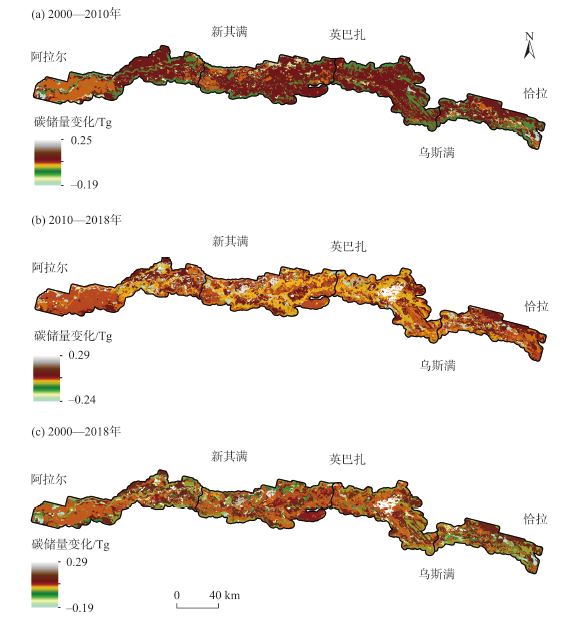
自2000年实施流域综合治理和2010年推行流域体制改革以来,塔里木河流域水资源管理能力不断增强。然而,水资源管理对流域生态系统固碳能力的提升效果如何,未曾开展评估。以胡杨林集中分布的塔里木河上中游为研究靶区,采用InVEST模型,基于2000年、2010年、2018年土地利用/覆被变化数据,分析了水资源管理增强下流域生态系统碳储量的变化特点。结果表明:(1) 2000年、2010年、2018年塔里木河上中游的总碳储量分别为93.70 Tg、93.92 Tg、93.01 Tg,平均碳密度分别为67.63 t·hm-2、67.78 t·hm-2、67.12 t·hm-2,基本保持稳定。林地是塔里木河上中游的主要碳库、草地次之。(2) 2000—2010年碳储量增加0.22 Tg,主要由于大量草地类型(69.35 t·hm-2)转化成耕地类型(73 t·hm-2)。自2000年塔里木河综合治理实施后,植被恢复使得地表生物量增多,林地、草地碳密度和碳储量增加;2010—2018年碳储量减少0.91 Tg,碳损失途径主要源于大量林地类型(73.77 t·hm-2)转化成耕地类型(73 t·hm-2),造成草地总碳储量降低。(3) 碳储量空间分布具有较强的空间异质性,其特点以塔里木河上中游为条带向四周波动递减。碳储量变化显著区域在空间分布上与土地利用变化区域基本一致。研究可为深入了解干旱区碳循环,提升流域生态系统固碳功能,优化水资源管理提供科学依据。
郭靖,王光焰,徐生武,张广朋,苑塏烨,凌红波,夏依旦·吾买尔江. 水资源管理增强下的塔里木河上中游碳储量动态评估[J]. 干旱区研究, 2021, 38(3): 589-599.
GUO Jing,WANG Guangyan,XU Shengwu,ZHANG Guangpeng,YUAN Kaiye,LING Hongbo,Xiayidan Wumaierjiang. Dynamic assessment of Tarim River carbon storage under enhanced water resources management[J]. Arid Zone Research, 2021, 38(3): 589-599.
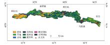
图1
塔里木河土地利用/覆被分布示意图"

表1
塔里木河上中游各土地利用类型的碳密度"
| 土地利用类型 | 碳密度/(t·hm-2) | 来源文献 | ||||||||
|---|---|---|---|---|---|---|---|---|---|---|
| 地上 | 地下 | 死亡有机物 | ||||||||
| 2000年 | 2010年 | 2018年 | 2000年 | 2010年 | 2018年 | 2000年 | 2010年 | 2018年 | ||
| 有林地 | 0.22 | 0.34 | 0.31 | 0.08 | 0.12 | 0.11 | 0.09 | 0.14 | 0.13 | [ |
| 疏林地 | 0.18 | 0.31 | 0.27 | 0.06 | 0.10 | 0.09 | 0.07 | 0.12 | 0.10 | [ |
| 灌木林 | 0.19 | 0.32 | 0.28 | 0.07 | 0.12 | 0.10 | 0.05 | 0.08 | 0.07 | [ |
| 草地 | 0.17 | 0.24 | 0.28 | 1.05 | 1.48 | 1.72 | 0.23 | 0.31 | 0.36 | [ |
| 耕地 | 0.48 | 0.60 | 0.63 | 0 | 0 | 0 | 0 | 0 | 0 | [ |
| 水域 | 0 | 0 | 0 | 0 | 0 | 0 | 0 | 0 | 0 | [ |
| 建设用地 | 0 | 0 | 0 | 0 | 0 | 0 | 0 | 0 | 0 | [ |
| 未利用地 | 0 | 0 | 0 | 0 | 0 | 0 | 0 | 0 | 0 | [ |
表2
2000—2018年塔里木河上中游土地利用面积和比例"
| 土地利用类型 | 2000年 | 2010年 | 2018年 | |||||
|---|---|---|---|---|---|---|---|---|
| 面积 /104 hm2 | 比例 /% | 面积 /104 hm2 | 比例 /% | 面积 /104 hm2 | 比例 /% | |||
| 耕地 | 17.93 | 12.94 | 25.96 | 18.74 | 29.59 | 21.36 | ||
| 林地 | 48.21 | 34.79 | 45.43 | 32.79 | 43.15 | 31.14 | ||
| 草地 | 43.75 | 31.57 | 37.38 | 26.98 | 34.66 | 25.01 | ||
| 水域 | 5.29 | 3.82 | 5.66 | 4.09 | 7.11 | 5.14 | ||
| 建设用地 | 0.44 | 0.31 | 0.60 | 0.43 | 0.87 | 0.63 | ||
| 未利用地 | 22.94 | 16.55 | 23.53 | 16.98 | 23.17 | 16.72 | ||
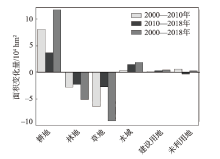
图2
2000—2018年塔里木河上中游各土地利用类型面积变化"
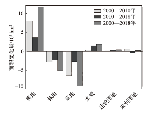
表3
2000—2018年塔里木河上中游土地利用转移矩阵"
| 时段 | 土地利用类型 | 耕地 | 林地 | 草地 | 水域 | 建设用地 | 未利用地 |
|---|---|---|---|---|---|---|---|
| 2000—2010年 | 耕地 | 176896.61 | 177.60 | 383.39 | 48.73 | 766.23 | 1719.71 |
| 林地 | 27648.10 | 449204.76 | 2058.00 | 667.94 | 154.98 | 2464.06 | |
| 草地 | 54605.15 | 3316.68 | 368312.73 | 7598.88 | 597.20 | 3475.37 | |
| 水域 | 1339.27 | 1311.52 | 2278.57 | 48370.14 | 0.00 | 79.32 | |
| 建设用地 | 7.52 | 0.00 | 0.00 | 0.00 | 4300.22 | 64.12 | |
| 未利用地 | 649.42 | 305.54 | 767.32 | 0.00 | 167.28 | 227538.47 | |
| 2010—2018年 | 耕地 | 236148.40 | 8436.27 | 10940.27 | 1674.75 | 2659.61 | 396.42 |
| 林地 | 32228.98 | 390551.31 | 16857.65 | 9479.26 | 98.81 | 5177.07 | |
| 草地 | 21869.35 | 21526.50 | 312625.53 | 7388.01 | 285.49 | 10240.00 | |
| 水域 | 635.14 | 2276.26 | 2314.57 | 51460.21 | 0.00 | 0.01 | |
| 建设用地 | 54.55 | 0.00 | 181.14 | 208.42 | 5367.00 | 167.28 | |
| 未利用地 | 5649.12 | 8854.76 | 3787.17 | 976.56 | 318.39 | 215738.47 |

图3
2000—2018年塔里木河上中游各土地利用类型下碳储量/碳密度变化"
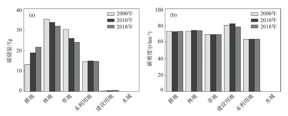
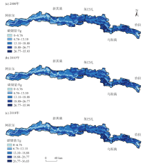
图4
2000—2018年塔里木河上中游碳储量空间分布"

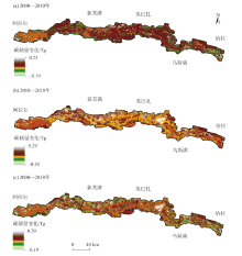
图5
2000—2018年塔里木河上中游碳储量变化空间分布"
| [1] | He Chunyang, Zhang Da, Huang Qingxu, et al. Assessing the potential impacts of urban expansion on regional carbon storage by linking the LUSD-urban and InVEST models[J]. Environmental Modelling & Software, 2016,75:44-58. |
| [2] | 王渊刚, 罗格平, 赵树斌, 等. 新疆耕地变化对区域碳平衡的影响[J]. 地理学报, 2014,69(1):110-120. |
| [ Wang Yuangang, Luo Geping, Zhao Shubin, et al. Effects of arable land change on regional carbon balance in Xinjiang[J]. Acta Geographica Sinica, 2014,69(1):110-120. ] | |
| [3] |
Sterling S M, Ducharne Agnès, Polcher J. The impact of global land-cover change on the terrestrial water cycle[J]. Nature Climate Change, 2012,3(4):385-390.
doi: 10.1038/nclimate1690 |
| [4] |
Vitousek P M, Mooney H A, Lubchenco J, et al. Human domination of earth's ecosystems[J]. Science, 1997,277(5325):494-499.
doi: 10.1126/science.277.5325.494 |
| [5] | 高扬, 何念鹏, 汪亚峰. 生态系统固碳特征及其研究进展[J]. 自然资源学报, 2013,28(7):1264-1274. |
| [ Gao Yang, He Nianpeng, Wang Yafeng. Characteristics of carbon sequestration by ecosystem and progress in its research[J]. Journal of Natural Resources, 2013,28(7):1264-1274. ] | |
| [6] | 张云倩, 张晓祥, 陈振杰, 等. 基于InVEST模型的江苏海岸带生态系统碳储量时空变化研究[J]. 水土保持研究, 2016,23(3):100-105. |
| [ Zhang Yunqian, Zhang Xiaoxiang, Chen Zhenjie, et al. Research on the spatiotemporal variation of carbon storage in coastal zone ecosystem of Jiangsu based on InVEST Model[J]. Research of Soil and Water Conservation, 2016,23(3):100-105. ] | |
| [7] |
Andreetta A, Huertas A D, Lotti M, et al. Land use changes affecting soil organic carbon storage along a mangrove swamp rice chronosequence in the Cacheu and Oio regions (northern Guinea-Bissau)[J]. Agriculture, Ecosystems and Environment, 2016,216:314-321.
doi: 10.1016/j.agee.2015.10.017 |
| [8] |
Gelaw A M, Singh B R, Lal R. Soil organic carbon and total nitrogen stocks under different land uses in a semi-arid watershed in Tigray, Northern Ethiopia[J]. Agriculture, Ecosystems and Environment, 2014,188:256-263.
doi: 10.1016/j.agee.2014.02.035 |
| [9] | 方精云, 郭兆迪, 朴世龙, 等. 1981—2000年中国陆地植被碳汇的估算[J]. 中国科学(D辑: 地球科学), 2007,37(6):804-812. |
| [ Fang Jingyun, Guo Zhaodi, Piao Shilong, et al. Assessment of China terrestrial vegetation carbon sinks in 1981-2000[J]. Science in China(Series D), 2007,37(6):804-812. ] | |
| [10] | 方精云, 刘国华, 徐嵩龄. 我国森林植被的生物量和净生产量[J]. 生态学报, 1996,16(5):497-508. |
| [ Fang Jingyun, Liu Guohua, Xu Songling. Biomass and net production of porest vegetation in China[J]. Acta Ecologica Sinica, 1996,16(5):497-508. ] | |
| [11] | 朴世龙, 方精云, 贺金生, 等. 中国草地植被生物量及其空间分布格局[J]. 植物生态学报, 2004,28(4):491-498. |
| [ Piao Shilong, Fang Jingyun, He Jinjie, et al. Spatial distribution of grassland biomass in China[J]. Acta Phytoecologica Sinica, 2004,28(4):491-498. ] | |
| [12] | 王淑君, 管东生, 黎夏, 等. 广州森林碳储量时空演变及异质性分析[J]. 环境科学学报, 2008,28(4):778-785. |
| [ Wang Shujun, Guan Dongsheng, Li Xia, et al. The spatial-temporal evolution and heterogeneity analysis of forest carbon storage in Guangzhou, China[J]. Acta Scientiae Circumstantiae, 2008,28(4):778-785. ] | |
| [13] | 杨玉海, 陈亚宁, 李卫红, 等. 塔里木河干流土地利用/覆被变化对土壤有机碳储量的影响[J]. 中国环境科学, 2016,36(9):2784-2790. |
| [ Yang Yuhai, Chen Yaning, Li Weihong, et al. Effects of land use/cover change on soil organic carbon storage in the main stream of Tarim River[J]. China Environmental Science, 2016,36(9):2784-2790. ] | |
| [14] | 尚二萍, 张红旗. 1980s—2010s新疆伊犁河谷草地碳存储动态评估[J]. 资源科学, 2016,38(7):1229-1238. |
| [ Shang Erping, Zhang Hongqi. Dynamic assessment of the carbon stock of different grassland types in the Yili Valley from 1980s to2010s[J]. Resources Science, 2016,38(7):1229-1238. ] | |
| [15] | Bae J, Ryu Y. Land use and land cover changes explain spatial and temporal variations of the soil organic carbon stocks in a constructed urban park[J]. Landscape & Urban Planning, 2015,136(136):57-67. |
| [16] | 邓铭江, 周海鹰, 徐海量, 等. 塔里木河干流上中游丰枯情景下生态水调控研究[J]. 干旱区研究, 2017,34(5):959-966. |
| [ Deng Mingjiang, Zhou Haiying, Xu Hailiang, et al. Regulation of ecological water volume under high-or low-flow in the mainstream area of the Tarim River[J]. Arid Zone Research, 2017,34(5):959-966. ] | |
| [17] | 黄运梅, 徐海量, 张广朋, 等. 基于年轮信息的单株胡杨(Populus euphratica)树干年新增生物量估算方法[J]. 干旱区研究, 2018,35(4):905-911. |
| [ Huang Yunmei, Xu Hailiang, Zhang Guangpeng, et al. Estimation of annual biomass of individual Populus euphratica based on tree-ring data[J]. Arid Zone Research, 2018,35(4):905-911. ] | |
| [18] | 陈亚宁, 崔旺诚, 李卫红, 等. 塔里木河的水资源利用与生态保护[J]. 地理学报, 2003,58(2):215-222. |
| [ Chen Yaning, Cui Wang-cheng, Li Weihong, et al. The influence of groundwater on vegetation in the lower reaches of Tarim River, China[J]. Acta Geographica Sinica, 2003,58(2):215-222. ] | |
| [19] | 徐海量, 陈亚宁, 杨戈. 塔里木河下游生态输水对植被和地下水位的影响[J]. 环境科学, 2003,24(4):18-22. |
| [ Xu Hailiang, Chen Yaning, Yang Ge. Effect of translating water on vegetation at the lower reaches of Tarim River[J]. Chinese Journal of Environmental Science, 2003,24(4):18-22. ] | |
| [20] | 徐海量, 陈亚宁, 李卫红. 塔里木河下游生态输水后地下水的响应研究[J]. 环境科学研究, 2003,16(2):19-22, 38. |
| [ Xu Hailiang, Chen Yaning, Li Weihong. Study on response of groundwater after ecological water transport at the lower reaches of the Tarim River[J]. Research of Environmental Sciences, 2003,16(2):19-22, 38. ] | |
| [21] | 熊宇斐, 张广朋, 陈超群, 等. 基于水量变化的塔里木河统一管理成效评价[J]. 自然资源学报, 2016,31(11):1806-1816. |
| [ Xiong Yufei, Zhang Guangpeng, Chen Chaoqun, et al. Effectiveness evaluation of the unified management based on water change in Tarim River Basin[J]. Journal of Natural Resources, 2016,31(11):1806-1816. ] | |
| [22] |
Chen Yaning, Takeuchi K, Xu Changchun, et al. Regional climate change and its effects on river runoff in the Tarim Basin, China[J]. Hydrological Processes, 2006,20(10):2207-2216.
doi: 10.1002/(ISSN)1099-1085 |
| [23] | 徐海量, 叶茂, 宋郁东, 等. 塔里木河流域水资源变化的特点与趋势[J]. 地理学报, 2005,60(3):487-494. |
| [ Xu Hailiang, Ye Mao, Song Yudong, et al. The dynamic variation of water resources and its tendency in Tarim River Basin[J]. Acta Geographica Sinica, 2005,60(3):487-494. ] | |
| [24] | 叶茂, 徐海量, 宋郁东, 等. 塔里木河流域水资源利用面临的主要问题[J]. 干旱区研究, 2006,23(3):388-392. |
| [ Ye Mao, Xu Hailiang, Song Yudong, et al. Some problems and challenges about water resources utilization in the Tarim River Basin[J]. Arid Zone Research, 2006,23(3):388-392. ] | |
| [25] | 张广朋, 徐海量, 杜清, 等. 塔里木河流域降水量的非线性时空变化对比研究及预测[J]. 水资源与水工程学报, 2015,26(2):58-63. |
| [ Zhang Guangpeng, Xu Hailiang, Du Qing, et al. Comparative study and prediction of nonlinear temporal and spatial variation of precipitation in Tarim River Basin[J]. Journal of Water Resources and Water Engineering, 2015,26(2):58-63. ] | |
| [26] | 白元, 徐海量, 凌红波, 等. 塔里木河干流区天然植被的空间分布及生态需水[J]. 中国沙漠, 2014,34(5):1410-1416. |
| [ Bai Yuan, Xu Hailiang, Ling Hongbo, et al. Spatial distribution characteristics and ecological water requirement of natural vegetation along the mainstream of the Tarim River[J]. Journal of Desert Research, 2014,34(5):1410-1416. ] | |
| [27] | Tallis H T, Ricketts T, Guerry A D, et al. In VEST 2.6.0 user’s guide. Stanford CA: The Natural Capital Project, 2013,24-29:233-250. |
| [28] | 郑拴丽, 许文强, 杨辽, 等. 新疆阿尔泰山森林生态系统碳密度与碳储量估算[J]. 自然资源学报, 2016,31(9):1553-1563. |
| [ Zheng Shuanli, Xu Wenqiang, Yang Liao, et al. Carbon density and storage of forest ecosystem in Altay Mountains, Xinjiang[J]. Journal of Natural Resources, 2016,31(9):1553-1563. ] | |
| [29] | 徐自为, 张智杰. 基于土地利用变更调查的2010—2016年新疆尉犁县生态系统碳储量时空变化[J]. 环境科学研究, 2018,31(11):1909-1917. |
| [ Xu Ziwei, Zhang Zhijie. Spatiotemporal variation of carbon storage in Yuli County during 2010-2016[J]. Research of Environmental Sciences, 2018,31(11):1909-1917. ] | |
| [30] | 包玉斌. 基于InVEST模型的陕北黄土高原生态服务功能时空变化研究[D]. 西安: 西北大学, 2015. |
| [ Bao Yubin. Temporal and Spatial Change of Ecological Services on Loess Plateau of Shaanxi by InVEST model[D]. Xi’an: Northwest University, 2015. ] | |
| [31] | 方精云, 杨元合, 马文红, 等. 中国草地生态系统碳库及其变化[J]. 中国科学(生命科学), 2010,40(7):566-576. |
| [ Fang Jingyun, Yang Yuanhe, Ma Wenhong, et al. Ecosystem carbon stocks and their changes in China’s grasslands[J]. Scientia Sinica Vitae(Life Sciences), 2010,40(7):566-576. ] | |
| [32] | 于东升, 史学正, 孙维侠, 等. 基于1∶100万土壤数据库的中国土壤有机碳密度及储量研究[J]. 应用生态学报, 2005,16(12):2279-2283. |
| [ Yu Dongsheng, Shi Xuezheng, Sun Weixia, et al. Estimation of China soil organic carbon storage and density based on 1: 1000000 soil database[J]. Chinese Journal of Applied Ecology, 2005,16(12):2279-2283. ] | |
| [33] | 李真. 干旱内陆河流域生态系统服务空间权衡与协同研究[D]. 兰州: 西北师范大学, 2017. |
| [ Li Zhen. The Dynamic Analysis on Trade-off s and Synergies of Ecosystem Services in the Arid Inland River Basin[D]. Lanzhou: Northwest Normal University, 2017. ] | |
| [34] | 张影, 谢余初, 齐姗姗, 等. 基于InVEST模型的甘肃白龙江流域生态系统碳储量及空间格局特征[J]. 资源科学, 2016,38(8):1585-1593. |
| [ Zhang Ying, Xie Yuchu, Qi Shanshan, et al. Carbon storage and spatial distribution characteristics on the Bailongjiang watershed in Gansu based on InVEST model[J]. Resources Science, 2016,38(8):1585-1593. ] | |
| [35] | 张斯屿, 白晓永, 王世杰, 等. 基于InVEST模型的典型石漠化地区生态系统服务评估——以晴隆县为例[J]. 地球环境学报, 2014,5(5):328-338. |
| [ Zhang Siyu, Bai Xiaoyong, Wang Shijie, et al. Ecosystem services evaluation of typical rocky desertification areas based on InVEST model: A case study at Qinglong County, Guizhou Province[J]. Journal of Earth Environment, 2014,5(5):328-338. ] | |
| [36] | 李敏. 基于InVEST模型的生态系统服务功能评价研究[D]. 北京: 北京林业大学, 2016. |
| [ Li Min. Ecosystem Services Evaluation Based on InVEST Model: ACase study of Yanqing, Beijing[D]. Beijing: Beijing Forestry University, 2016. ] | |
| [37] | 贾芳芳. 基于InVEST模型的赣江流域生态系统服务功能评估[D]. 北京: 中国地质大学, 2014. |
| [ Jia Fangfang. InVEST Model Based Ecosystem Services Evaluation with case case study on Ganjiang River Basin[D]. Beijing: China University of Geosciences, 2014. ] | |
| [38] | 白元, 徐海量, 凌红波, 等. 塔里木河干流区土地利用与生态系统服务价值的变化[J]. 中国沙漠, 2013,33(6):1912-1920. |
| [ Bai Yuan, Xu Hailiang, Ling Hongbo, et al. Analysis on land use changes and ecosystem services value in the area along the Tarim River[J]. Journal of Desert Research, 2013,33(6):1912-1920. ] | |
| [39] |
戴尔阜, 翟瑞雪, 葛全胜, 等. 1980s—2010s内蒙古草地表层土壤有机碳储量及其变化[J]. 地理学报, 2014,69(11):1651-1660.
doi: 10.11821/dlxb201411006 |
|
[ Dai Erfu, Zhai Ruixue, Ge Quansheng, et al. Topsoil organic carbon storage and its changes in Inner Mongolia grassland from the 1980s to 2010s[J]. Acta Geographica Sinica, 2014,69(11):1651-1660. ]
doi: 10.11821/dlxb201411006 |
|
| [40] | 方岳, 刘华, 白志强, 等. 新疆喀纳斯保护区森林碳储量及碳密度研究[J]. 南京林业大学学报(自然科学版), 2014,38(6):17-22. |
| [ Fang Yue, Liu Hua, Bai Zhiqiang, et al. Spatial pattern of carbon storage and carbon density in forest vegetation of the Kanas National Natural Reserve[J]. Journal of Nanjing Forestry University (Natural Sciences Edition), 2014,38(6):17-22. ] | |
| [41] | 赵锐锋, 陈亚宁, 李卫红, 等. 塔里木河干流区土地覆被变化与景观格局分析[J]. 地理学报, 2009,64(1):95-106. |
| [ Zhao Ruifeng, Chen Yaning, Li Weihong, et al. Land cover change and landscape pattern in the mainstream of the Tarim River[J]. Acta Geographica Sinica, 2009,64(1):95-106. ] | |
| [42] | 孙美琴, 赵成义, 施枫芝, 等. 近20 a塔里木河干流区土地利用变化特征[J]. 干旱区研究, 2013,30(1):16-21. |
| [ Sun Meiqin, Zhao Chengyi, Shi Fengzhi, et al. Analysis on land use change in the mainstream area of the Tarim River in recent 20 years[J]. Arid Zone Research, 2013,30(1):16-21. ] |
| [1] | 吴朝巧, 林菲, 牛俊杰, 耿甜伟. 山西中部城市群生态系统服务对土地利用格局变化的响应[J]. 干旱区研究, 2024, 41(7): 1153-1166. |
| [2] | 李冰洁, 范志韬, 曲芷程, 姚顺予, 宿夏姝, 刘东伟, 王立新. 基于InVEST-PLUS模型的黄河流域内蒙古段生态系统碳储量评价及预测[J]. 干旱区研究, 2024, 41(7): 1217-1227. |
| [3] | 张顺鑫, 吴子豪, 闫庆武, 李桂娥, 牟守国. 基于PLUS-InVEST模型的天山北坡生态系统碳储量时空变化与预测[J]. 干旱区研究, 2024, 41(7): 1228-1237. |
| [4] | 杨荣钦, 肖玉磊, 池苗苗, 穆振侠. 近20 a塔里木河流域人类活动及景观生态风险时空变化[J]. 干旱区研究, 2024, 41(6): 1010-1020. |
| [5] | 高雅玉, 宋玉, 赵廷红, 高金芳, 何文博, 李泽霞. 马莲河下游产水量时空演变特征[J]. 干旱区研究, 2024, 41(5): 776-787. |
| [6] | 程晓瑜, 吕洁华. 塔里木河流域碳储量的气候影响机制及地形分异下的归因[J]. 干旱区研究, 2024, 41(5): 865-875. |
| [7] | 刘如龙, 赵媛媛, 陈国清, 迟文峰, 刘正佳. 内蒙古黄河流域1990—2020年生境质量评估[J]. 干旱区研究, 2024, 41(4): 674-683. |
| [8] | 李佳珂, 邵战林. 基于PLUS和InVEST模型的乌鲁木齐市碳储量时空演变与预测[J]. 干旱区研究, 2024, 41(3): 499-508. |
| [9] | 严莉, 曹广超, 康利刚, 刘梦琳, 叶得力. 基于InVEST模型的共和县生境质量时空变化及驱动因素[J]. 干旱区研究, 2024, 41(2): 314-325. |
| [10] | 王洋, 冯卓亚, 许丽, 高文信. 塔里木河流域生境质量与土地利用变化响应及驱动力[J]. 干旱区研究, 2024, 41(12): 2132-2142. |
| [11] | 张音, 孙从建, 刘庚, 钞锦龙, 耿甜伟. 近20 a塔里木河流域山区NDSI对气候变化的响应[J]. 干旱区研究, 2024, 41(10): 1639-1648. |
| [12] | 申草,任宗萍,李鹏,王凯博,鲁克新,任正龑,魏小燕. 宁夏水土保持生态补偿优先区识别[J]. 干旱区研究, 2023, 40(9): 1527-1536. |
| [13] | 马继龙, 史军辉, 王新英, 阿丽亚·拜都热拉, 刘茂秀, 艾吉尔·阿不拉. 洪水漫溢对塔里木河中游河岸胡杨林土壤有机碳及活性组分的影响[J]. 干旱区研究, 2023, 40(8): 1248-1257. |
| [14] | 张晓敏, 张东梅, 张伟. 人类活动对额尔齐斯河流域碳储量的影响[J]. 干旱区研究, 2023, 40(8): 1333-1345. |
| [15] | 包玉斌,王耀宗,路锋,刘自增,马大为,杨勇,吴娟,张永康. 六盘山区国土空间生态安全格局构建与分区优化[J]. 干旱区研究, 2023, 40(7): 1172-1183. |
|
||