干旱区研究 ›› 2022, Vol. 39 ›› Issue (5): 1631-1641.doi: 10.13866/j.azr.2022.05.27 cstr: 32277.14.AZR.20220527
龙志1,2,3( ),孙颖琦1,4,郎丽霞1,2,3,陈兴鹏1,2,3(),张子龙1,4,庞家幸1,5,6
收稿日期:2022-02-24
修回日期:2022-05-15
出版日期:2022-09-15
发布日期:2022-10-25
作者简介:龙志(1991-),男,博士,研究方向为低碳与区域可持续发展. E-mail: 基金资助:
LONG Zhi1,2,3(),SUN Yingqi1,4,LANG Lixia1,2,3,CHEN Xingpeng1,2,3(),ZHANG Zilong1,4,PANG Jiaxing1,5,6
Received:2022-02-24
Revised:2022-05-15
Published:2022-09-15
Online:2022-10-25
摘要:
县域是中国碳排放的重要组成部分和碳汇功能的主要承载空间,更是双碳目标和政策落实的关键行政单元。以庆城县为例,探讨黄土高原典型县域的碳排放特征和时空格局,为推动黄河流域生态保护,实现高质量发展和绿色低碳转型提供启示和参考。结果表明:(1) 欠发达地区县域碳排放变化和结构具有鲜明的特征。规模以下工业是庆城县最大的碳排放来源,工业碳排放比重低,第三产业和生活碳排放比重相对较高。(2) 庆城县碳排放空间分布符合帕累托法则,即80%的碳排放集中在20%的区域,总体表现为“整体分散,局部集聚”的空间分布特征。高碳区主要集中在川区、残塬区和县城区;中碳区主要分布在残塬区和交通沿线;低碳区则广泛分布于梁峁沟壑区。(3) 受地形地貌影响,黄土高原县域碳排放呈现出明显的时空格局差异。县城、工业集中区、主要乡镇等中、高碳区最大斑块指数增加,整体性提高,碳源多样性减少,类型趋于单一化。交通沿线和城乡居民聚居区等中碳区与低碳区交错地带碳源多样性增加,聚集度降低。
龙志,孙颖琦,郎丽霞,陈兴鹏,张子龙,庞家幸. 黄土高原典型县域碳排放特征与时空格局——以庆城县为例[J]. 干旱区研究, 2022, 39(5): 1631-1641.
LONG Zhi,SUN Yingqi,LANG Lixia,CHEN Xingpeng,ZHANG Zilong,PANG Jiaxing. Spatiotemporal patterns and characteristics of carbon emissions in the Loess Plateau: A case study of Qingcheng County[J]. Arid Zone Research, 2022, 39(5): 1631-1641.
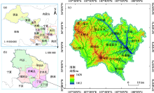
图1
庆城县地理位置示意图 注:底图采用甘肃省自然资源厅标准地图制作,审图号为甘S(2017)70号(a)、甘S(2011)22号(b)和甘庆S(2019)4号(c),对底图边界无修改。下同。"

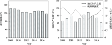
图2
2008—2017年庆城县碳排放量及其强度变化"
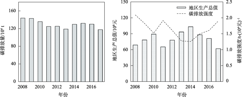
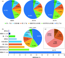
图3
2008—2017年庆城县碳排放结构及变化特征"
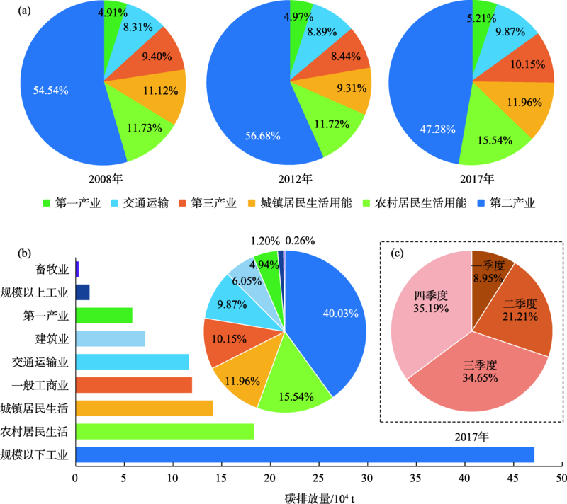
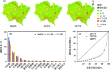
图4
2008—2017年庆城县碳排放时空特征"

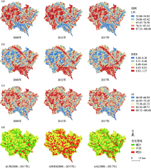
图5
2008—2017年庆城县碳排放LPI、SHDI、AI指数变化时空格局"

| [1] |
陈宇. 人类命运共同体视域中的国家传统疆域与新疆域[J]. 世界地理研究, 2021, 30(5): 893-902.
doi: 10.3969/j.issn.1004-9479.2021.05.2020648 |
|
[Chen Yu. Analysis on the traditional frontier and modrern frontier from the vision of Community of Shared Future[J]. World Regional Studies, 2021, 30(5): 893-902. ]
doi: 10.3969/j.issn.1004-9479.2021.05.2020648 |
|
| [2] |
Khan Uzma, Wang Huili, Ali Ishraq. A sustainable community of shared future for mankind: Origin, evolution and philosophical foundation[J]. Sustainability, 2021, 13(16): 9352. doi: 10.3390/su13169352.
doi: 10.3390/su13169352 |
| [3] |
Nathan Andrew J, Zhang Boshu. ‘A shared future for mankind’: Rhetoric and reality in Chinese foreign policy under Xi Jinping[J]. Journal of Contemporary China, 2022, 31(133): 57-71.
doi: 10.1080/10670564.2021.1926091 |
| [4] |
Zhang Hui. A community of shared future for mankind: The contemporary development of the social foundations theory of international law[J]. Social Sciences in China, 2019, 40(1): 186-202.
doi: 10.1080/02529203.2019.1556489 |
| [5] |
Lashof Daniel A, Ahuja Dilip R. Relative contributions of greenhouse gas emissions to global warming[J]. Nature, 1990, 344: 529-531.
doi: 10.1038/344529a0 |
| [6] |
Samset B H, Sand M, Smith C J, et al. Climate impacts from a removal of anthropogenic aerosol emissions[J]. Geophysical Research Letters, 2018, 45(2): 1020-1029.
doi: 10.1002/2017GL076079 pmid: 32801404 |
| [7] |
He Huachun, Guan Hongjun, Zhu Xiang, et al. Assessment on the energy flow and carbon emissions of integrated steelmaking plants[J]. Energy Reports, 2017, 3: 29-36.
doi: 10.1016/j.egyr.2017.01.001 |
| [8] |
Yuan Jiahai, Xu Yan, Hu Zheng, et al. Peak energy consumption and CO2 emissions in China[J]. Energy Policy, 2014, 68: 508-523.
doi: 10.1016/j.enpol.2014.01.019 |
| [9] |
Long Zhi, Zhang Zilong, Liang Sai, et al. Spatially explicit carbon emissions at the county scale[J]. Resources, Conservation and Recycling, 2021, 173: 105706. doi: 10.1016/j.resconrec.2021.105706.
doi: 10.1016/j.resconrec.2021.105706 |
| [10] |
Shan Yuli, Huang Qi, Guan Dabo, et al. China CO2 emission accounts 2016-2017[J]. Scientific Data, 2020, 7(1): 54. doi: 10.1038/s41597-020-0393-y.
doi: 10.1038/s41597-020-0393-y |
| [11] |
Sarkodie Samuel Asumadu. Environmental performance, biocapacity, carbon & ecological footprint of nations: Drivers, trends and mitigation options[J]. Science of the Total Environment, 2021, 751: 141912. doi: 10.1016/j.scitotenv.2020.141912.
doi: 10.1016/j.scitotenv.2020.141912 |
| [12] |
Zhang Wei, Li Jing, Li Guoxiang, et al. Emission reduction effect and carbon market efficiency of carbon emissions trading policy in China[J]. Energy, 2020, 196: 117117. doi: 10.1016/j.energy.2020.117117.
doi: 10.1016/j.energy.2020.117117 |
| [13] |
Zhou Huijun, Ping Weiying, Wang Yong, et al. China’s initial allocation of interprovincial carbon emission rights considering historical carbon transfers: Program design and efficiency evaluation[J]. Ecological Indicators, 2021, 121: 106918. doi: 10.1016/j.ecolind.2020.106918.
doi: 10.1016/j.ecolind.2020.106918 |
| [14] |
Guo Qianqian, Su Zhifang, Chiao Chaoshin. Carbon emissions trading policy, carbon finance, and carbon emissions reduction: evidence from a quasi-natural experiment in China[J]. Economic Change and Restructuring, 2022, 55(3): 1445-1480.
doi: 10.1007/s10644-021-09353-5 |
| [15] |
Li Yanmei, Li Tingting, Lu Shuangshuang. Forecast of urban traffic carbon emission and analysis of influencing factors[J]. Energy Efficiency, 2021, 14(8): 84. doi: 10.1007/s12053-021-10001-0.
doi: 10.1007/s12053-021-10001-0 |
| [16] |
Deutch John. Decoupling economic growth and carbon emissions[J]. Joule, 2017, 1(1): 3-5.
doi: 10.1016/j.joule.2017.08.011 |
| [17] |
Khan Khalid, Su Chiwei. Urbanization and carbon emissions: A panel threshold analysis[J]. Environmental Science and Pollution Research, 2021, 28(20): 26073-26081.
doi: 10.1007/s11356-021-12443-6 |
| [18] |
Wang Keying, Wu Meng, Sun Yongping, et al. Resource abundance, industrial structure, and regional carbon emissions efficiency in China[J]. Resources Policy, 2019, 60: 203-214.
doi: 10.1016/j.resourpol.2019.01.001 |
| [19] | 范志欣, 方修琦, 苏筠. 全球碳排放格网化格局的变化[J]. 气候变化研究进展, 2018, 14(5): 505-512. |
| [Fan Zhixin, Fang Xiuqi, Su Yun. Changes in global grid pattern of carbon emissions[J]. Climate Change Research, 2018, 14(5): 505-512. ] | |
| [20] |
Cai Bofeng, Wang Xiuquan, Huang Guohe, et al. Spatiotemporal changes of China’s carbon emissions[J]. Geophysical Research Letters, 2018, 45(16): 8536-8546.
doi: 10.1029/2018GL079564 |
| [21] |
Chen Jiandong, Gao Ming, Cheng Shulei, et al. County-level CO2 emissions and sequestration in China during 1997-2017[J]. Scientific Data, 2020, 7(1): 391. doi: 10.1038/s41597-020-00736-3.
doi: 10.1038/s41597-020-00736-3 pmid: 33184289 |
| [22] |
Chen Qianli, Cai Bofeng, Dhakal Shobhakar, et al. CO2 emission data for Chinese cities[J]. Resources, Conservation and Recycling, 2017, 126: 198-208.
doi: 10.1016/j.resconrec.2017.07.011 |
| [23] |
Chen Yi, Wang Xinyu, Sha Zhijie, et al. Uncertainty analysis for multi-state weighted behaviours of rural area with carbon dioxide emission estimation[J]. Applied Soft Computing, 2012, 12(8): 2631-2637.
doi: 10.1016/j.asoc.2012.04.014 |
| [24] |
Song Dan, Su Meirong, Yang Jin, et al. Greenhouse gas emission accounting and management of low-carbon community[J]. Scientific World Journal, 2012, 2012: 613721. doi: 10.1100/2012/613721.
doi: 10.1100/2012/613721 |
| [25] |
Zhang Zengkai, Guan Dabo, Wang Ran, et al. Embodied carbon emissions in the supply chains of multinational enterprises[J]. Nature Climate Change, 2020, 10(12): 1096-1101.
doi: 10.1038/s41558-020-0895-9 |
| [26] |
Chandio Abbas Ali, Akram Waqar, Ahmad Fayyaz, et al. Dynamic relationship among agriculture-energy-forestry and carbon dioxide (CO2) emissions: Empirical evidence from China[J]. Environmental Science and Pollution Research, 2020, 27 (27): 34078-34089.
doi: 10.1007/s11356-020-09560-z |
| [27] |
Cheng YungHsiang, Chang YuHern, Lu I J. Urban transportation energy and carbon dioxide emission reduction strategies[J]. Applied Energy, 2015, 157: 953-973.
doi: 10.1016/j.apenergy.2015.01.126 pmid: 32287935 |
| [28] | 李雪梅, 张庆. 天津市能源消费碳排放影响因素及其情景预测[J]. 干旱区研究, 2019, 36(4): 997-1004. |
| [Li Xuemei, Zhang Qing. Factors affecting carbon emission from energy consumption in Tianjin[J]. Arid Zone Research, 2019, 36(4): 997-1004. ] | |
| [29] | Huang Lizhen, Krigsvoll Guri, Johansen Fred, et al. Carbon emission of global construction sector[J]. Renewable & Sustainable Energy Reviews, 2018, 81: 1906-1916. |
| [30] |
Lenzen Manfred, Sun Yayen, Faturay Futu, et al. The carbon footprint of global tourism[J]. Nature Climate Change, 2018, 8(6): 522-528.
doi: 10.1038/s41558-018-0141-x |
| [31] |
Prastiyo Slamet Eko, Irham, Hardyastuti Suhatmini, et al. How agriculture, manufacture, and urbanization induced carbon emission? The case of Indonesia[J]. Environmental Science and Pollution Research, 2020, 27(33): 42092-42103.
doi: 10.1007/s11356-020-10148-w |
| [32] | Yang Lisha, Lin Boqiang. Carbon dioxide-emission in China’s power industry: Evidence and policy implications[J]. Renewable & Sustainable Energy Reviews, 2016, 60: 258-267. |
| [33] |
Chu Yingmin, Xie Luyue, Yuan Zaijian. Composition and spatiotemporal distribution of the agro-ecosystem carbon footprint: A case study in Hebei Province, North China[J]. Journal of Cleaner Production, 2018, 190: 838-846.
doi: 10.1016/j.jclepro.2018.04.111 |
| [34] |
刘竹, 关大博, 魏伟. 中国二氧化碳排放数据核算[J]. 中国科学: 地球科学, 2018, 48(7): 878-887.
doi: 10.1360/N072017-00009 |
|
[Liu Zhu, Guan Dabo, Wei Wei. Carbon emission accounting in China[J]. Scientia Sinica Terrae, 2018, 48(7): 878-887. ]
doi: 10.1360/N072017-00009 |
|
| [35] |
Pei Jie, Niu Zheng, Wang Li, et al. Spatial-temporal dynamics of carbon emissions and carbon sinks in economically developed areas of China: A case study of Guangdong Province[J]. Scientific Reports, 2018, 8(1): 13383. doi: 10.1038/s41598-018-31733-7.
doi: 10.1038/s41598-018-31733-7 pmid: 30190515 |
| [36] |
Shan Yuli, Guan Dabo, Zheng Heran, et al. Data descriptor: China CO2 emission accounts 1997-2015[J]. Scientific Data, 2018, 5: 170201. doi: 10.1038/sdata.2017.201.
doi: 10.1038/sdata.2017.201 |
| [37] |
Wei Wendong, Wang Xibo, Zhu He, et al. Carbon emissions of urban power grid in Jing-Jin-Ji region: Characteristics and influential factors[J]. Journal of Cleaner Production, 2017, 168: 428-440.
doi: 10.1016/j.jclepro.2017.09.015 |
| [38] |
Cai Bofeng, Guo Huanxiu, Ma Zipeng, et al. Benchmarking carbon emissions efficiency in Chinese cities: A comparative study based on high-resolution gridded data[J]. Applied Energy, 2019, 242: 994-1009.
doi: 10.1016/j.apenergy.2019.03.146 |
| [39] |
Mi Zhifu, Guan Dabo, Liu Zhu, et al. Cities: The core of climate change mitigation[J]. Journal of Cleaner Production, 2019, 207: 582-589.
doi: 10.1016/j.jclepro.2018.10.034 |
| [40] |
Mi Zhifu, Zheng Jiali, Meng Jing, etal. Carbon emissions of cities from a consumption-based perspective[J]. Applied Energy, 2019, 235: 509-518.
doi: 10.1016/j.apenergy.2018.10.137 |
| [41] |
Shao Ling, Guan Dabo, Zhang Ning, et al. Carbon emissions from fossil fuel consumption of Beijing in 2012[J]. Environmental Research Letters, 2016, 11(11): 114028. doi: 10.1088/1748-9326/11/11/114028.
doi: 10.1088/1748-9326/11/11/114028 |
| [42] |
王少剑, 谢紫寒, 王泽宏. 中国县域碳排放的时空演变及影响因素[J]. 地理学报, 2021, 76(12): 3103-3118.
doi: 10.11821/dlxb202112016 |
|
[Wang Shaojian, Xie Zihan, Wang Zehong. The spatiotemporal pattern evolution and influencing factors of CO2 emissions at the county level of China[J]. Acta Geographica Sinica, 2021, 76(12): 3103-3118. ]
doi: 10.11821/dlxb202112016 |
|
| [43] |
刘华军, 邵明吉, 吉元梦. 中国碳排放的空间格局及分布动态演进——基于县域碳排放数据的实证研究[J]. 地理科学, 2021, 41(11): 1917-1924.
doi: 10.13249/j.cnki.sgs.2021.11.005 |
|
[Liu Huajun, Shao Mingji, Ji Yuanmeng. The spatial pattern and distribution dynamic evolution of carbon emissions in China: Empirical study based on county carbon emission data[J]. Scientia Geographica Sinica, 2021, 41(11): 1917-1924. ]
doi: 10.13249/j.cnki.sgs.2021.11.005 |
|
| [44] |
莫惠斌, 王少剑. 黄河流域县域碳排放的时空格局演变及空间效应机制[J]. 地理科学, 2021, 41(8): 1324-1335.
doi: 10.13249/j.cnki.sgs.2021.08.003 |
|
[Mo Huibin, Wang Shaojian. Spatio-temporal evolution and spatial effect mechanism of carbon emission at county level in the Yellow River Basin[J]. Scientia Geographica Sinica, 2021, 41(8): 1324-1335. ]
doi: 10.13249/j.cnki.sgs.2021.08.003 |
|
| [45] | 胡孟然. 中国县域碳排放空间格局及影响因素研究[D]. 兰州: 兰州大学, 2021. |
| [Hu Mengran. Spatial Pattern and Influencing Factors of Carbon Emissions at County Level in China[D]. Lanzhou: Lanzhou University, 2021. ] | |
| [46] | 刘畅, 苏筠, 黎玲玲. 中国县域能源消费碳排放估算及其空间分布[J]. 环境污染与防治, 2020, 42(1): 113-119. |
| [Liu Chang, Su Yun, Li Lingling. The estimation and spatial distribution of the carbon emissions of county units in China[J]. Environmental Pollution and Control, 2020, 42(1): 113-119 ] | |
| [47] |
汪浩, 陈操操, 潘涛, 等. 县域尺度的京津冀都市圈CO2排放时空演变特征[J]. 环境科学, 2014, 35(1): 385-393.
doi: 10.1021/es001204i |
|
[Wang Hao, Chen Caocao, Pan Tao, et al. County scale characteristics of CO2emission’s spatial-temporal evolution in the Beijing-Tianjin-Hebei metropolitan region[J]. Environmental Science, 2014, 35(1): 385-393. ]
doi: 10.1021/es001204i |
|
| [48] | 朱松丽, 汪航, 王文涛, 等. “十二五”期间中国区域低碳经济与国土空间开发格局的协调发展研究[J]. 中国人口·资源与环境, 2017, 27 (9): 135-142. |
| [Zhu Songli, Wang Hang, Wang Wentao, et al. Status of coordinated development between regional low-carbon economy and spatial land-use pattern in the 12th Five Year Plan[J]. China Population, Resources and Environment, 2017, 27(9): 135-142 ] | |
| [49] | 胡向东, 王济民. 中国畜禽温室气体排放量估算[J]. 农业工程学报, 2010, 26 (10): 247-252. |
| [Hu Xiangdong, Wang Jimin. Estimation of livestock greenhouse gases discharge in China[J]. Transactions of the CSAE, 2010, 26(10): 247-252. ] | |
| [50] | 刘培芳, 陈振楼, 许世远, 等. 长江三角洲城郊畜禽粪便的污染负荷及其防治对策[J]. 长江流域资源与环境, 2002, 11(5): 456-460. |
| [Liu Peifang, Chen Zhenlou, Xu Shiyuan, et al. Waste loading and treatment strategies on the excreta of domestic animals in the Yangtze Delta[J]. Resources and Environment in the Yangtze Basin, 2002, 11(5): 456-460. ] | |
| [51] | 宋奇, 史舟, 冯春晖, 等. 基于1990—2019年多时相影像的干旱区绿洲景观格局分析[J]. 干旱区研究, 2022, 39(2): 594-604. |
| [Song Qi, Shi Zhou, Feng Chunhui, et al. Analysis of landscape pattern from 1990 to 2019 based on multi-temporal imagery in arid oasis[J]. Arid Zone Research, 2022, 39(2): 594-604. ] | |
| [52] | 郭杰, 丁冠乔, 刘晓曼, 等. 城镇景观格局对区域碳排放影响及其差别化管控研究[J]. 中国人口·资源与环境, 2018, 28(10): 55-61. |
| [Guo Jie, Ding Guanqiao, Liu Xiaoman, et al. Effect of urban landscape pattern on regional carbon emissions and its differential regulation[J]. China Population, Resources and Environment, 2018, 28(10): 55-61. ] | |
| [53] | 朱东国, 谢炳庚, 熊鹏. 基于三维景观格局指数的张家界市土地利用格局时空演化[J]. 经济地理, 2017, 37(8): 168-175. |
| [Zhu Dongguo, Xie Binggeng, Xiong Peng. Spatial-temporal evolution of land-use pattern changes in Zhangjiajie city based on three-dimensional landscape pattern indices[J]. Economic Geography, 2017, 37(8): 168-175. ] | |
| [54] |
付扬军, 师学义, 和娟. 汾河流域景观破碎化时空演变特征[J]. 自然资源学报, 2019, 34(8): 1606-1619.
doi: 10.31497/zrzyxb.20190804 |
|
[Fu Yangjun, Shi Xueyi, He Juan. The spatio-temporal evolution characteristics of landscape fragmentation in Fenhe River Basin[J]. Journal of Natural Resources, 2019, 34(8): 1606-1619. ]
doi: 10.31497/zrzyxb.20190804 |
|
| [55] | 张皓玮, 李欣, 殷如梦, 等. 旅游城镇化地区土地利用景观格局指数的粒度效应——以扬州市广陵区为例[J]. 南京师大学报 (自然科学版), 2018, 41(3): 122-130. |
| [Zhang Haowei, Li Xin, Yin Rumeng, et al. Grain size effect of urbanization tourist areas of land use landscape pattern index: A case study of Guangling district of Yangzhou[J]. Journal of Nanjing Normal University (Natural Science Edition), 2018, 41(3): 122-130. ] | |
| [56] | 马振刚, 李黎黎, 许学工, 等. 北方农牧交错带地区土地利用的粒度效应研究——以化德县为例[J]. 干旱区资源与环境, 2016, 30(5): 92-98. |
| [Ma Zhengang, Li Lili, Xu Xuegong, et al. Grain size effects of land-use in farming-pastoral transitional zone of northern China: A case study of Huade county[J]. Journal of Arid Land Resources and Environment, 2016, 30(5): 92-98. ] | |
| [57] | 寇星亮. 长庆油田机关搬迁事件的社会学分析[D]. 兰州: 兰州大学, 2013. |
| [Kou Xingliang. A Sociological Analysis on the Event of Changqiong Oilfield Unites’ Relocation[D]. Lanzhou: Lanzhou University, 2013. ] | |
| [58] | 张子龙, 王博, 龙志, 等. 财政分权、产业升级、技术进步与“资源诅咒”——基于黄河流域资源型城市的实证分析[J]. 经济经纬, 2021, 38(3): 133-141. |
| [Zhang Zilong, Wang Bo, Long Zhi, et al. Fiscal decentralization, industrial upgrading, technological progress and “resource curse”: Empirical analysis of resource-based cities in the Yellow River Basin[J]. Economic Survey, 2021, 38(3): 133-141. ] |
| [1] | 李宇航, 余文学, 杨永均, 朱燕峰, 马静, 陈浮. 近60 a天山北坡经济带天然径流量时空变化及归因识别[J]. 干旱区研究, 2024, 41(9): 1446-1455. |
| [2] | 邱春霞, 刘晓宏, 李豆, 张佳淼, 李朋飞. 机载LiDAR和模糊推理系统在黄土高原土壤侵蚀监测中的应用[J]. 干旱区研究, 2024, 41(8): 1331-1342. |
| [3] | 山建安, 朱睿, 尹振良, 杨华庆, 张薇, 方春爽. 基于CMIP6模式的中国西北地区干旱时空变化[J]. 干旱区研究, 2024, 41(5): 717-729. |
| [4] | 毛光锐, 赵锦梅, 朱恭, 崔海明, 刘万智. 黄土高原高速公路边坡草本群落植被特征及其与土壤的关系[J]. 干旱区研究, 2024, 41(5): 788-796. |
| [5] | 王鑫盈, 马超, 吕立群, 张岩. 黄土高原不同土地利用类型区浅层滑坡侵蚀特征分析——以蔡家川滑坡事件为例[J]. 干旱区研究, 2024, 41(4): 697-705. |
| [6] | 包佳玉, 李祥龙, 胡启文, 李涛. 新疆能源消费碳排放时空特征及能源结构调整路径探讨[J]. 干旱区研究, 2024, 41(3): 490-498. |
| [7] | 邢欣然, 张祎, 李鹏, 刘晓君, 陶清瑞, 任正龑, 胥世斌. 模拟干湿条件下土壤酶活性对坝地土壤有机碳矿化的影响[J]. 干旱区研究, 2024, 41(11): 1969-1980. |
| [8] | 赵雨琪, 魏天兴. 1990—2020年黄土高原典型县域植被覆盖变化及影响因素[J]. 干旱区研究, 2024, 41(1): 147-156. |
| [9] | 吕锦心, 梁康, 刘昌明, 张仪辉, 刘璐. 无定河流域土地覆被空间分异机制及相关水碳变量变化[J]. 干旱区研究, 2023, 40(4): 563-572. |
| [10] | 孙贯芳, 高照良, 朱焱, 杨金忠, 屈忠义. 时空克里金评估河套灌区土壤盐分时空格局[J]. 干旱区研究, 2023, 40(2): 182-193. |
| [11] | 裴宏泽, 赵亚超, 张廷龙. 2000—2020年黄土高原NEP时空格局与驱动力[J]. 干旱区研究, 2023, 40(11): 1833-1844. |
| [12] | 刘欢欢, 陈印, 刘悦, 刚成诚. 基于随机森林模型的黄土高原草地净初级生产力时空格局及未来演变趋势模拟[J]. 干旱区研究, 2023, 40(1): 123-131. |
| [13] | 王娇娇, 尹小君, 刘陕南, 王帝盟. 基于深度学习的玛纳斯土地利用时空格局变化与预测[J]. 干旱区研究, 2023, 40(1): 69-77. |
| [14] | 安彬,肖薇薇,朱妮,刘宇峰. 近60 a黄土高原地区降水集中度与集中期时空变化特征[J]. 干旱区研究, 2022, 39(5): 1333-1344. |
| [15] | 冯强,赵文武,段宝玲. 生态系统服务权衡强度与供需匹配度的关联性分析——以山西省为例[J]. 干旱区研究, 2022, 39(4): 1222-1233. |
|
||