干旱区研究 ›› 2025, Vol. 42 ›› Issue (7): 1323-1332.doi: 10.13866/j.azr.2025.07.15 cstr: 32277.14.AZR.20250715
黄龙1( ), 古斯乐图2, 周彩婷1, 杨夏瑶1, 司月君1, 黄日辉1, 杭晓菊2, 牛东风1()
收稿日期:2024-10-11
修回日期:2025-04-30
出版日期:2025-07-15
发布日期:2025-07-07
通讯作者:
牛东风. E-mail: niudongfeng@lingnan.edu.cn作者简介:黄龙(1993-),男,博士,讲师,主要从事光释光年代学与地貌学研究. E-mail: huanglong@lingnan.edu.cn
基金资助:
HUANG Long1(), Gusiletu 2, ZHOU Caiting1, YANG Xiayao1, SI Yuejun1, HUANG Rihui1, HANG Xiaoju2, NIU Dongfeng1()
Received:2024-10-11
Revised:2025-04-30
Published:2025-07-15
Online:2025-07-07
摘要: 中国东北季风边缘区沙地对气候变化响应敏感,是研究风沙演化历史的理想场所。本文对科尔沁沙地(KE)和浑善达克沙地(HS)的两个典型风成沉积物剖面进行光释光定年分析,结合剖面沉积相所指示的环境信息,重建区域风沙演化历史,并探讨影响风沙堆积的因素。结果表明:(1) KE剖面在9.8~3.0 ka期间发育深黑色砂质古土壤,指示了风沙活动较弱;近0.2 ka以来剖面发育了较厚的浅灰色砂质古土壤,暗示了区域风沙活动较强,导致表层较厚的沉积物不断地被“翻新”而难以形成沉积年代较老的沉积物。(2) HS剖面在13.4 ka、1.2~0.5 ka及0.5 ka以来沉积灰黄色风沙层,指示了风沙活动较强;在11.6~1.9 ka前后发育深黑色砂质古土壤,指示了风沙活动较弱。(3) 13.4 ka以来研究区域古气候与风沙演化大致经历了三个阶段:13.4 ka至早全新世整体转暖,风沙活动较强;早-中全新世温暖湿润,风沙活动弱;晚全新世气候波动转冷,风沙活动较强。(4) KE与HS剖面深黑色砂质古土壤发育时间差异可能反映了沙地边缘区局地地形、气候等因素对风沙堆积和古土壤发育具有重要影响。
黄龙, 古斯乐图, 周彩婷, 杨夏瑶, 司月君, 黄日辉, 杭晓菊, 牛东风. 中国东北季风边缘区沙地风成沉积剖面光释光定年研究及其古环境意义[J]. 干旱区研究, 2025, 42(7): 1323-1332.
HUANG Long, Gusiletu , ZHOU Caiting, YANG Xiayao, SI Yuejun, HUANG Rihui, HANG Xiaoju, NIU Dongfeng. Optically stimulated luminescence dating of aeolian sediment profiles in the sandy areas of northeastern China near the edge of the monsoon zone and its paleoenvironmental significance[J]. Arid Zone Research, 2025, 42(7): 1323-1332.
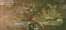
图1
研究区域示意图"


图2
采样剖面示意图"

表1
研究剖面沉积物划分、特征描述和采样深度"
| 剖面 | 深度/m | 地层沉积学特征描述 |
|---|---|---|
| KE | 0~4.3 | 浅灰色砂质古土壤,较松散,颗粒较粗,125 μm粒径较多,有植物根系穿插其中,采样KE-1,采样深度为2 m |
| 4.3~8.3 | 深黑色砂质古土壤,较松散,颗粒较细,90 μm粒径较多,于该层顶部和底部分别采样KE-2(4.3 m)和KE-3(8.3 m) | |
| >8.3 | 浅灰色砂质古土壤,较松散,颗粒较粗,未见底 | |
| HS | 0~0.3 | 灰黄色风沙层,有大量植物根系穿插其中,沉积物非常松散,颗粒粗 |
| 0.3~0.7 | 浅灰色砂质古土壤,较松散,颗粒较粗,125 μm粒径较多,采样HS-1(0.6 m) | |
| 0.7~0.9 | 灰黄色风沙层,较松散,颗粒粗 | |
| 0.9~1.6 | 浅灰色砂质古土壤,较松散,颗粒较粗,125 μm粒径较多,采样HS-2(1.1 m) | |
| 1.6~2.6 | 深黑色砂质古土壤,较松散,颗粒较细,90 μm粒径较多,于该层顶部和底部采样HS-3(1.7 m)和HS-4(2.6 m) | |
| >2.6 | 灰黄色风沙层,较松散,颗粒粗,125~150 μm粒径较多,采样HS-5(3.1 m),未见底 |
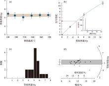
图3
HS-3样品的预热实验测试(a)、光释光信号衰减曲线与剂量响应曲线(b)、等效剂量频率分布图(c)和雷达投影图(d)"

表2
科尔沁沙地和浑善达克沙地剖面样品的光释光定年结果"
| 样品号 | Th/(μg·g-1)a | U/(μg·g-1)a | K/%a | 含水量/%b | 宇宙射线/(Gy·ka-1)c | 埋藏深度/m | 年剂量率/(Gy·ka-1) | 等效剂量/Gy | 年龄/ka |
|---|---|---|---|---|---|---|---|---|---|
| KE-1 | 4.16 | 0.98 | 2.08 | 5 | 0.18 | 2.0 | 2.64±0.11 | 0.46±0.03 | 0.2±0.1 |
| KE-2 | 4.54 | 1.00 | 1.92 | 5 | 0.14 | 4.3 | 2.47±0.11 | 7.37±0.33 | 3.0±0.2 |
| KE-3 | 4.93 | 1.23 | 2.33 | 5 | 0.09 | 8.3 | 2.89±0.13 | 28.37±1.34 | 9.8±0.6 |
| HS-1 | 2.33 | 0.71 | 2.07 | 5 | 0.24 | 0.6 | 2.51±0.11 | 1.29±0.10 | 0.5±0.1 |
| HS-2 | 2.00 | 0.53 | 2.08 | 5 | 0.23 | 1.1 | 2.44±0.10 | 2.87±0.23 | 1.2±0.1 |
| HS-3 | 3.32 | 0.93 | 2.09 | 5 | 0.21 | 1.7 | 2.61±0.11 | 5.08±0.18 | 1.9±0.1 |
| HS-4 | 2.64 | 0.82 | 2.14 | 5 | 0.19 | 2.6 | 2.56±0.11 | 29.78±2.60 | 11.6±1.1 |
| HS-5 | 1.71 | 0.62 | 2.19 | 5 | 0.18 | 3.1 | 2.49±0.11 | 33.25±2.26 | 13.4±1.1 |
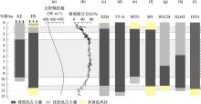
图4
研究剖面地层序列与其他相关的记录对比 注:图(a)为65°N太阳辐射量值[28],图(b)为公海湖沉积物中树孢粉记录[29],图(c)、图(d)和图(e)为科尔沁沙地剖面地层序列图[30-31],图(f)、图(g)和图(h)为浑善达克沙地剖面地层序列图[31,33],图(i)为浑善达克沙地东南部附近的剖面地层序列图[37]。"


图5
研究区域地形图"

| [1] | Liu T S, An Z S, Yuan B Y. Eolian process and dust mantle (loess) in China[J]. Quaternary Sciences, 1985, 6(1): 113-125. |
| [2] | 夏玉梅. 科尔沁沙地南缘虻石沟黄土地层孢粉分析与古环境的探讨[J]. 中国沙漠, 1989, 9(4): 22-29. |
| [Xia Yumei. A study on the pollen analysis and paleoenvironment of loess stratigraphy in Menshigou in South Edge of Horgin Sandy Land[J]. Journal of Desert Research, 1989, 9(4): 22-29.] | |
| [3] | 董光荣, 金炯, 高尚玉, 等. 晚更新世以来我国北方沙漠地区的气候变化[J]. 第四纪研究, 1990, 10(3): 213-222. |
| [Dong Guangrong, Jin Jiong, Gao Shangyu, et al. Climatic changes since the Late Pleistocene in deserts of Northern China[J]. Quaternary Sciences, 1990, 10(3): 213-222.] | |
| [4] | 裘善文. 试论科尔沁沙地的形成与演变[J]. 地理科学, 1989, 9(4): 317-328, 97. |
|
[Qiu Shanwen. Study on the formation and evolution of Horqin Sandy Land[J]. Scientia Geographica Sinica, 1989, 9(4): 317-328, 97.]
doi: 10.13249/j.cnki.sgs.1989.04.317 |
|
| [5] | 李森, 孙武, 李孝泽, 等. 浑善达克沙地全新世沉积特征与环境演变[J]. 中国沙漠, 1995, 15(4): 323-331. |
| [Li Sen, Sun Wu, Li Xiaoze, et al. Sedimentary characteristics and environmental evolution of Otindag land in Holocene[J]. Journal of Desert Research, 1995, 15(4): 323-331.] | |
| [6] | 李明启, 靳鹤龄, 张洪, 等. 浑善达克沙地磁化率和有机质揭示的全新世气候变化[J]. 沉积学报, 2005, 23(4): 683-689. |
| [Li Mingqi, Jin Heling, Zhang Hong, et al. Climate change revealed by magnetic susceptibility and organic matter during the Holocene in Hunshandak Desert[J]. Acta Sedimentologica Sinica, 2005, 23(4): 683-689.] | |
| [7] | 鹿化煜, 弋双文, 徐志伟, 等. 末次盛冰期和全新世大暖期中国沙漠沙地的空间格局[J]. 科学通报, 2013, 58(23): 2775-2783. |
| [Lu Huayu, Yi Shuangwen, Xu Zhiwei, et al. Chinese deserts and sand fields in Last Glacial Maximum and Holocene Optimum[J]. Chinese Science Bulletin, 2013, 58(23): 2775-2783.] | |
| [8] | 周亚利, 鹿化煜, 张家富, 等. 高精度光释光测年揭示的晚第四纪毛乌素和浑善达克沙地沙丘的固定与活化过程[J]. 中国沙漠, 2005, 25(3): 342-350. |
| [Zhou Yali, Lu Huayu, Zhang Jiafu, et al. Active and inactive phases of sand-dune in Mu Us and Otindag Sandlands during late Quaternary suggested by OSL dating[J]. Journal of Desert Research, 2005, 25(3): 342-350.] | |
| [9] | 弋双文, 鹿化煜, 周亚利, 等. 晚第四纪科尔沁沙地干湿变化的黄土记录[J]. 中国沙漠, 2006, 26(6): 869-874. |
| [Yi Shuangwen, Lu Huayu, Zhou Yali, et al. The wet-dry variations of the Horqin Sandy field recorded by loess deposit of the late Quaternary[J]. Journal of Desert Research, 2006, 26(6): 869-874.] | |
| [10] | 赵爽, 夏敦胜, 靳鹤龄, 等. 科尔沁沙地过去近5000年高分辨率气候演变[J]. 第四纪研究, 2013, 33(2): 283-292. |
| [Zhao Shuang, Xia Dunsheng, Jin Heling, et al. High-resolution climate evolution record of the Horqin Sandy Land since about 5000 cal.aB.P.[J]. Quaternary Sciences, 2013, 33(2): 283-292.] | |
| [11] | 刘冰, 靳鹤龄, 孙忠. 近6 ka以来科尔沁沙地东部气候变化记录[J]. 中国沙漠, 2011, 31(6): 1398-1405. |
| [Liu Bing, Jin Heling, Sun Zhong. Climate change in East Horqin Sandy Land since 6.0 ka BP[J]. Journal of Desert Research, 2011, 31(6): 1398-1405.] | |
| [12] |
薛文萍, 靳鹤龄, 刘冰, 等. 中国季风边缘区全新世沙地演化及其驱动机制研究进展[J]. 中国沙漠, 2019, 39(3): 163-171.
doi: 10.7522/j.issn.1000-694X.2018.00084 |
|
[Xue Wenping, Jin Heling, Liu Bing, et al. Advances in the study of sandy land evolution and driving mechanism in the monsoonal marge in area in China during the Holocene Epoch[J]. Journal of Desert Research, 2019, 39(3): 163-171.]
doi: 10.7522/j.issn.1000-694X.2018.00084 |
|
| [13] | Xu Z W, Mason J A, Xu C, et al. Critical transitions in Chinese dunes during the past 12000 years[J]. Science Advances, 2020, 6(9): eaay8020 |
| [14] | Zhong H E, Jie Z, Linhai Y, et al. Holocene dune mobility and forcing mechanisms at the Northern margin of the East Asian Monsoon[J]. Acta Geologica Sinica-English Edition, 2013, 87(4): 1168-1178. |
| [15] | 周亚利, 鹿化煜, Mason J A, 等. 浑善达克沙地的光释光年代序列与全新世气候变化[J]. 中国科学(D辑: 地球科学), 2008, 38(4): 452-462. |
| [Zhou Yali, Lu Huayu, Mason J A, et al. Photoluminescence chronosequence and Holocene climate change in the Hunsandak Sandy Area[J]. Science China (Series D: Earth Sciences), 2008, 38(4): 452-462.] | |
| [16] | Zhao H, Lu Y, Yin J. Optical dating of Holocene sand dune activities in the Horqin sand-fields in Inner Mongolia, China, using the SAR protocol[J]. Quaternary Geochronology, 2007, 2(1-4): 29-33. |
| [17] | 韩鹏, 孙继敏. 浑善达克沙地的光释光测年研究[J]. 第四纪研究, 2004, 24(4): 480. |
| [Han Peng, Sun Jimin. Photoluminescence photometric dating study of the Hunsandak sands[J]. Quaternary Sciences, 2004, 24(4): 480.] | |
| [18] | 杨小平, 梁鹏, 方伊曼, 等. 中国沙漠与环境演变[M]. 北京: 科学出版社, 2024. |
| [Yang Xiaoping, Liang Peng, Fang Yiman, et al. Chinese Desserts and Environmental Changes[M]. Beijing: Science Press, 2024.] | |
| [19] | 李思慧. 1961—2018年科尔沁沙地气候变化特征[J]. 内蒙古气象, 2019(5): 8-10. |
| [Li Sihui. Characteristics of climate change in Horqin Sandy Land from 1961 to 2018[J]. Meteorology Journal of Inner Mongolia, 2019(5): 8-10.] | |
| [20] | 杨晓刚, 宝音, 张静, 等. 克什克腾旗加强草原生态保护与修复促进草原资源可持续发展[J]. 内蒙古林业, 2022(7): 9-11. |
| [Yang Xiaogang, Baoyin, Zhang Jing, et al. Strengthening grassland ecological protection and restoration in Keshiketeng Banner to promote the sustainable development of grassland resources[J]. Inner Mongolia Forestry, 2022(7): 9-11.] | |
| [21] | Yang X, Wang X, Liu Z, et al. Initiation and variation of the dune fields in semi-arid China-with a special reference to the Hunshandake Sandy Land, Inner Mongolia[J]. Quaternary Science Reviews, 2013, 78: 369-380. |
| [22] | Murray A S, Wintle A G. Luminescence dating of quartz using an improved single-aliquot regenerative dose protocol[J]. Radiation Measurements, 2000, 32(1): 57-73. |
| [23] | Wintle A G, Murray A S. A review of quartz optically stimulated luminescence characteristics and their relevance in single-aliquot regeneration dating protocols[J]. Radiation Measurements, 2006, 41(4): 369-391. |
| [24] | Prescott J R, Hutton J T. Cosmic ray contributions to dose rates for luminescence and ESR dating: Large depths and long-term time variations[J]. Radiation Measurements, 1994, 23(2): 497-500. |
| [25] | Lu H Y, Mason J A, Stevens T, et al. Response of surface processes to climatic change in the dune fields and Loess Plateau of North China during the late Quaternary[J]. Earth Surface Processes and Landforms, 2011, 36(12): 1590-1603. |
| [26] | Ding Z L, Derbyshire E, Yang S L, et al. Stepwise expansion of desert environment across northern China in the past 3.5 Ma and implications for monsoon evolution[J]. Earth and Planetary Science Letters, 2005, 237(1-2): 45-55. |
| [27] |
徐志伟, 鹿化煜. 毛乌素沙地风沙环境变化研究的理论和新认识[J]. 地理学报, 2021, 76(9): 2203-2223.
doi: 10.11821/dlxb202109012 |
|
[Xu Zhiwei, Lu Huayu. Aeolian environmental change studies in the Mu Us Sandy Land, north-central China: Theory and recent progress[J]. Acta Geographica Sinica, 2021, 76(9): 2203-2223.]
doi: 10.11821/dlxb202109012 |
|
| [28] | Laskar J, Robutel P, Joutel F, et al. A long-term numerical solution for the insolation quantities of the Earth[J]. Astronomy & Astrophysics, 2004, 428(1): 261-285. |
| [29] | Chen F H, Xu Q H, Chen J H, et al. East Asian summer monsoon precipitation variability since the last deglaciation[J]. Scientific Reports, 2015, 5(1): 1-11. |
| [30] | 弋双文, 鹿化煜, 曾琳, 等. 末次盛冰期以来科尔沁沙地古气候变化及其边界重建[J]. 第四纪研究, 2013, 33(2): 206-217. |
| [Yi Shuangwen, Lu Huayu, Zeng Lin, et al. Paleoclimate changes and reconstruction of the border of Horqin dune field (Northeastern China) since the Last Glacial maximum[J]. Quaternary Sciences, 2013, 33(2): 206-217.] | |
| [31] | 杨萍. 中国东部沙区全新世砂质古土壤与古气候变化[D]. 金华: 浙江师范大学, 2014. |
| [Yang Ping. Paleoclimate Changes of Deserts of Eastern China Recorded by Sandy Paleosol[D]. Jinhua: Zhejiang Normal Univesity, 2014.] | |
| [32] | 田娅琪, 周亚利, 孙晓巍, 等. 末次盛冰期以来浑善达克沙地光释光年代学及气候变化研究[J/OL]. 沉积学报, 1-20 [2024-07-15]. |
| [Tian Yaqi, Zhou Yali, Sun Xiaowei, et al. Optically stimulated luminescence chronology and climate change in the Otindag Sandy and since the Last Glacial Maximum[J/OL]. Acta Sedimentologica Sinica, 1-20 [2024-07-15].] | |
| [33] | 杨小平, 梁鹏, 张德国, 等. 中国东部沙漠/沙地全新世地层序列及其古环境[J]. 中国科学: 地球科学, 2019, 49(8): 1293-1307. |
| [Yang Xiaoping, Liang Peng, Zhang Deguo, et al. Holocene aeolian stratigraphic sequences in the eastern portion of the desert belt (sand seas and sandy lands) in northern China and their palaeoenvironmental implications[J]. Science China Earth Sciences, 2019, 49(8): 1293-1307.] | |
| [34] | 杨利荣, 岳乐平. 浑善达克沙地末次冰期晚期到全新世的环境转型[J]. 地球环境学报, 2011, 2(1): 301-306. |
| [Yang Lirong, Yue Leping. The environmental transformation from late last glacial to Holocene of Otindag Sandy Land[J]. Journal of Earth Environment, 2011, 2(1): 301-306.] | |
| [35] | 郑琳, 谢东, 于尧, 等. 1961—2018年浑善达克沙地气候变化分析[J]. 现代农业科技, 2024(19): 117-120. |
| [Zheng Lin, Xie Dong, Yu Yao, et al. Analysis of climate change in Otindag Sandy Land from 1961 to 2018[J]. Modern Agricultural Science and Technology, 2024(19): 117-120.] | |
| [36] | 姚淑珍, 王补生, 杜瑛红, 等. 克什克腾旗自然降水资源分析[J]. 内蒙古农业科技, 2012(3): 108-109. |
| [Yao Shuzhen, Wang Busheng, Du Yinghong, et al. Analysis of precipitation resources in the Kashketeng Banner[J]. Journal of Northern Agriculture, 2012(3): 108-109.] | |
| [37] | 周亚利, 鹿化煜, 张小艳, 等. 末次盛冰期和全新世大暖期浑善达克沙地边界的变化[J]. 第四纪研究, 2013, 33(2): 228-242. |
| [Zhou Yali, Lu Huayu, Zhang Xiaoyan, et al. Changes of the before of Otindag Sand field (northern China) during the last glacial maximum and Holocene optimum[J]. Quaternary Sciences, 2013, 33(2): 228-242.] |
| [1] | 高海燕, 张胜男, 杨制国, 张雷, 黄海广, 闫德仁. 科尔沁沙地油松固沙林土壤真菌群落结构及功能[J]. 干旱区研究, 2025, 42(1): 118-126. |
| [2] | 吉吉佳门, 程一本, 谌玲珑, 万鹏翔, 张祎晖, 杨文斌, 白旭赢, 王涛. 科尔沁沙地樟子松人工林土壤水分动态及其对降雨的响应[J]. 干旱区研究, 2023, 40(5): 756-766. |
| [3] | 马浩文, 王永芳, 郭恩亮. 基于GEE的翁牛特旗土地沙漠化遥感监测[J]. 干旱区研究, 2023, 40(3): 504-516. |
| [4] | 吴蕊, 曹红雨, 高广磊, 于明含, 丁国栋, 张英, 赵珮杉. 科尔沁沙地水盐处理对油莎豆农田土壤细菌群落及植株生理特性的影响[J]. 干旱区研究, 2023, 40(12): 1938-1948. |
| [5] | 任孝宗,王嵩松,王亚梅,罗进洪,马永桃. 浑善达克沙地西部新月形沙丘和抛物线沙丘共存区的地貌特征[J]. 干旱区研究, 2023, 40(12): 2016-2030. |
| [6] | 陈臻琦,张靖,张贻龙,刘睿. 基于VSD的近20 a来浑善达克沙地生态脆弱性变化研究[J]. 干旱区研究, 2021, 38(5): 1464-1473. |
| [7] | 崔珍珍,马超,陈登魁. 1982—2015年科尔沁沙地植被时空变化及气候响应[J]. 干旱区研究, 2021, 38(2): 536-544. |
| [8] | 曹文梅,刘廷玺,王喜喜,王冠丽,李东方,童新. 科尔沁沙丘草甸相间地区土地利用与覆被识别[J]. 干旱区研究, 2021, 38(2): 526-535. |
| [9] | 孙姗姗, 刘新平, 魏水莲, 张铜会, 何玉惠, 车力木格, 吕朋, 王明明. 沙地植物幼苗生长对降水和风速变化的响应[J]. 干旱区研究, 2019, 36(4): 870-877. |
| [10] | 任孝宗, 李建刚, 刘敏, 李继彦. 浑善达克沙地东部地区天然水体的水化学组成及其控制因素[J]. 干旱区研究, 2019, 36(4): 791-800. |
| [11] | 包永志, 刘廷玺, 段利民, 王冠丽, 祁秀娇, 黄天宇, 黎明扬. 科尔沁沙地混生小叶锦鸡儿和人工杨树光合特性及其对气候的响应 [J]. 干旱区研究, 2019, 36(2): 420-429. |
| [12] | 张晶, 左小安, 吕朋, 岳喜元, 张婧. 科尔沁沙地典型草地植物功能性状及其相互关系[J]. 干旱区研究, 2018, 35(01): 137-143. |
| [13] | 蒋德明,张娜,阿拉木萨,周全来,王永翠,苗仁辉,押田敏雄. 科尔沁沙地人工固沙植被优化配置模式试验研究[J]. 干旱区研究, 2014, 31(1): 149-156. |
| [14] | 苗纯萍, 李雪华, 蒋德明. 科尔沁沙地流动沙丘-丘间低地过渡带植被分布特征及种间关联[J]. 干旱区研究, 2013, 30(5): 832-837. |
| [15] | 王海燕, 刘廷玺, 王力, 吴尧, 王天帅, 童新. 科尔沁沙地坨甸交错区土壤水分的空间变异规律[J]. 干旱区研究, 2013, 30(3): 438-443. |
|
||