干旱区研究 ›› 2024, Vol. 41 ›› Issue (10): 1639-1648.doi: 10.13866/j.azr.2024.10.03 cstr: 32277.14.AZR.20241003
张音1,2( ), 孙从建3(), 刘庚1,2, 钞锦龙1,2, 耿甜伟1,2
收稿日期:2024-04-18
修回日期:2024-06-06
出版日期:2024-10-15
发布日期:2024-10-14
通讯作者:
孙从建. E-mail: suncongjian@sina.com作者简介:张音(1995-),女,博士,讲师,研究方向为水文水资源. E-mail: zhyin3621@163.com
基金资助:
ZHANG Yin1,2(), SUN Congjian3(), LIU Geng1,2, CHAO Jinlong1,2, GENG Tianwei1,2
Received:2024-04-18
Revised:2024-06-06
Published:2024-10-15
Online:2024-10-14
摘要:
NDSI(归一化差异积雪指数)是一种评估地表积雪覆盖程度的指数,对研究山区积雪变化有重要作用。本研究基于2001—2022年遥感数据和再分析数据,采用趋势分析法、多元线性回归法等,分析了近20 a来塔里木河流域山区NDSI时空变化及其归因。结果表明:塔里木河流域山区2001—2022年NDSI均呈下降趋势,具有显著的空间异质性。北部和西部山区,NDSI值的季节变化相同,NDSI平均值从高到低为:冬季>春季>秋季>夏季,而南部山区的NDSI平均值夏季高于秋季。塔里木河流域山区年均实际蒸散发均呈上升趋势。北部山区的降水呈略微下降的趋势,而西部和南部山区表现为上升趋势。所有山区的饱和水汽压差均呈上升趋势。下行地表太阳辐射呈下降趋势。北部和西部山区的最低气温呈上升趋势,南部山区略呈下降趋势,而所有区域最高气温均呈上升趋势。众多变量中,气温和饱和水汽压对NDSI的影响较大。本研究可为政策决策提供科学依据。
张音, 孙从建, 刘庚, 钞锦龙, 耿甜伟. 近20 a塔里木河流域山区NDSI对气候变化的响应[J]. 干旱区研究, 2024, 41(10): 1639-1648.
ZHANG Yin, SUN Congjian, LIU Geng, CHAO Jinlong, GENG Tianwei. Response of NDSI in the Tarim River Basin mountainous areas to climate change over the past 20 years[J]. Arid Zone Research, 2024, 41(10): 1639-1648.
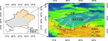
图1
研究区概况图 注:底图采用自然资源部标准地图制作,审图号为GS(2023)2767号,对底图边界无修改。下同。"

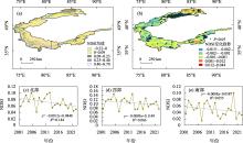
图2
2001—2022年流域山区(>1500 m)NDSI的时空变化(a、c~e)及其变化趋势(b)"

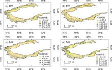
图3
2001—2022年流域NDSI的季节空间变化"

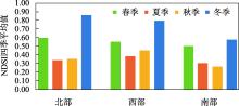
图4
2001—2022年流域NDSI的四季平均值"

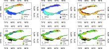
图5
2001—2022年流域AET、PRE和VPD的空间分布"

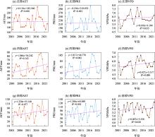
图6
2001—2022年流域AET、PRE和VPD的变化趋势"

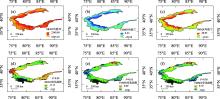
图7
2001—2022年流域SRAD、TMMN、TMMX的空间分布"

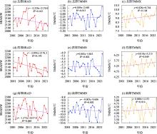
图8
2001—2022年流域SRAD、TMMN、TMMX的变化趋势"

表1
NDSI与各变量之间的回归系数"
| β1(AET) | β2(PRE) | β3(VPD) | β4(SRAD) | β5(TMMN) | β6(TMMX) | ||
|---|---|---|---|---|---|---|---|
| 北部 | 年均值 | -0.13* | 0.48* | 0.89* | -0.18* | -0.60* | -0.53* |
| 春季 | -0.16* | -0.15* | -0.16* | 0.40* | 0.26* | -0.53* | |
| 夏季 | -0.19* | 0.54* | -0.37* | -0.86* | -1.94* | 3.48* | |
| 秋季 | -0.24* | -0.11* | -1.09* | -0.37* | -0.64* | 1.95* | |
| 冬季 | 0.16* | -0.34* | -0.65* | -0.14* | -0.01 | 0.33* | |
| 西部 | 年均值 | -0.10* | 0.12* | 0.81* | -0.88* | -1.89* | 1.08* |
| 春季 | 0.20* | 0.32* | 0.48* | 0.44* | -1.22* | 0.45* | |
| 夏季 | 0.14* | -0.02 | 0.84* | -0.37* | -1.73* | 1.17* | |
| 秋季 | 0.24* | 0.20* | 0.73* | 0.47* | -0.82* | -0.29 | |
| 冬季 | 0.00 | 0.18* | 0.51* | -0.38* | -2.63* | 2.39* | |
| 南部 | 年均值 | -0.32* | 0.21* | 0.84* | -0.92* | -2.32* | 1.68* |
| 春季 | 0.32* | -0.06* | 0.67* | 0.01 | 2.89* | -3.85* | |
| 夏季 | -0.14* | -0.02 | 0.54* | -0.32* | 1.13* | -1.60* | |
| 秋季 | 0.12* | -0.13* | 0.98* | 0.05* | 1.93* | -3.15* | |
| 冬季 | 0.09* | -0.01 | -0.19* | -0.03 | 0.11 | 0.01 |
| [1] | 康世昌, 郭万钦, 钟歆玥, 等. 全球山地冰冻圈变化、影响与适应[J]. 气候变化研究进展, 2020, 16(2): 143-152. |
| [Kang Shichang, Guo Wanqin, Zhong Xinyue, et al. Changes in the mountain cryosphere and their impacts and adaptation measures[J]. Climate Change Research, 2020, 16(2): 143-152.] | |
| [2] |
肖雄新, 张廷军. 基于被动微波遥感的积雪深度和雪水当量反演研究进展[J]. 地球科学进展, 2018, 33(6): 590-605.
doi: 10.11867/j.issn.1001-8166.2018.06.0590 |
|
[Xiao Xiongxin, Zhang Tingjun. Passive microwave remote sensing of snow depth and snow water equivalent: Overview[J]. Advances in Earth Science, 2018, 33(6): 590-605.]
doi: 10.11867/j.issn.1001-8166.2018.06.0590 |
|
| [3] |
孙成杰, 王剑庚, 张永宏, 等. 2002—2021年北半球中高纬度典型山脉积雪的时空变化对比分析[J]. 冰川冻土, 2024, 46(2): 475-488.
doi: 10.7522/j.issn.1000-0240.2024.0039 |
|
[Sun Chengjie, Wang Jiangeng, Zhang Yonghong, et al. Spatiotemporal variations and comparative analysis of snow cover at typical mid to high latitudes mountain ranges in the Northern Hemisphere from 2002 to 2021[J]. Journal of Glaciology and Geocryology, 2024, 46(2): 475-488.]
doi: 10.7522/j.issn.1000-0240.2024.0039 |
|
| [4] | 效存德, 杨佼, 张通, 等. 冰冻圈变化的可预测性、不可逆性和深度不确定性[J]. 气候变化研究进展, 2022, 18(1): 1-11. |
| [Xiao Cunde, Yang Jiao, Zhang Tong, et al. The predictability, irreversibility and deep uncertainty of cryospheric change[J]. Climate Change Research, 2022, 18(1): 1-11.] | |
| [5] |
王建, 车涛, 李震, 等. 中国积雪特性及分布调查[J]. 地球科学进展, 2018, 33(1): 12-26.
doi: 10.11867/j.issn.1001-8166.2018.01.0012 |
|
[Wang Jian, Che Tao, Li Zhen, et al. Investigation on snow characteristics and their distribution in China[J]. Advances in Earth Science, 2018, 33(1): 12-26.]
doi: 10.11867/j.issn.1001-8166.2018.01.0012 |
|
| [6] |
曹晓云, 肖建设, 郝晓华, 等. 2001—2020年三江源地区积雪日数变化及地形分异[J]. 干旱区地理, 2022, 45(5): 1370-1380.
doi: 10.12118/j.issn.1000-6060.2021.599 |
|
[Cao Xiaoyun, Xiao Jianshe, Hao Xiaohua, et al. Variation of snow cover days and topographic differentiation in Sanjiangyuan area from 2001 to 2020[J]. Arid Land Geography, 2022, 45(5): 1370-1380.]
doi: 10.12118/j.issn.1000-6060.2021.599 |
|
| [7] |
李虹, 李忠勤, 陈普晨, 等. 近20 a新疆阿尔泰山积雪时空变化及其影响因素[J]. 干旱区研究, 2023, 40(7): 1040-1051.
doi: 10.13866/j.azr.2023.07.02 |
|
[Li Hong, Li Zhongqin, Chen Puchen, et al. Spatio-temporal variation of snow cover in Altai Mountains of Xinjiang in recent 20 years and its influencing factors[J]. Arid Zone Research, 2023, 40(7): 1040-1051.]
doi: 10.13866/j.azr.2023.07.02 |
|
| [8] | Notarnicola C. Hotspots of snow cover changes in global mountain regions over 2000-2018[J]. Remote Sensing of Environment: An Interdisciplinary Journal, 2020, 243: 111781. |
| [9] |
黄晓东, 马英, 李雨馨, 等. 1980—2020年青藏高原积雪时空变化特征[J]. 冰川冻土, 2023, 45(2): 423-434.
doi: 10.7522/j.issn.1000-0240.2023.0032 |
|
[Huang Xiaodong, Ma Ying, Li Yuxin, et al. Spatiotemporal variation characteristics of snow cover over the Tibetan Plateau from 1980 to 2020[J]. Journal of Glaciology and Geocryology, 2023, 45(2): 423-434.]
doi: 10.7522/j.issn.1000-0240.2023.0032 |
|
| [10] | 钟鼎杰, 孙梦鑫, 张岳, 等. 2001—2020年川西高原积雪时空变化及影响因素分析研究[J]. 干旱区资源与环境, 2021, 35(11): 111-118. |
| [Zhong Dingjie, Sun Mengxin, Zhang Yue, et al. Spatio-temporal variation and influencing factors of snow cover in West Sichuan plateau from 2001 to 2020[J]. Journal of Arid Land Resources and Environment, 2021, 35(11): 111-118.] | |
| [11] | Brown R D, Robinson D A. Northern Hemisphere spring snow cover variability and change over 1922-2010 including an assessment of uncertainty[J]. Cryosphere, 2011, 5(1): 219-229. |
| [12] | Mudryk L R, Kushner P J, Derksen C, et al. Snow cover response to temperature in observational and climate model ensembles[J]. Geophysical Research Letters, 2017, 44: 919-926. |
| [13] | 秦艳, 丁建丽, 赵求东, 等. 2001—2015年天山山区积雪时空变化及其与温度和降水的关系[J]. 冰川冻土, 2018, 40(2): 249-260. |
|
[Qin Yan, Ding Jianli, Zhao Qiudong, et al. Spatial-temporal variation of snow cover in the Tianshan Mountains from 2001 to 2015, and its relation to temperature and precipitation[J]. Journal of Glaciology and Geocryology, 2018 40(2): 249-260.]
doi: 10.7522/j.issn.1000-0240.2018.0029 |
|
| [14] | Moghadas S, Leonhardt G, Marsalek J, et al. Modeling urban runoff from Rain-on-Snow events with the US EPA SWMM model for current and future climate scenarios[J]. Journal of Cold Regions Engineering, 2018, 32(1): 04017021. |
| [15] |
张齐飞, 陈亚宁, 孙从建, 等. 塔里木河流域水储量变化及绿洲生态安全评估[J]. 干旱区地理, 2024, 47(1): 1-14.
doi: 10.12118/j.issn.1000-6060.2023.247 |
|
[Zhang Qifei, Chen Yaning, Sun Congjian, et al. Changes in terrestrial water storage and evaluation of oasis ecological security in the Tarim River Basin[J]. Arid Land Geography, 2024, 47(1): 1-14.]
doi: 10.12118/j.issn.1000-6060.2023.247 |
|
| [16] |
王诗语, 孙从建, 陈伟, 等. 基于水化学及径流组成的中国西北内陆河流域水资源风险评估[J]. 地理学报, 2023, 78(11): 2763-2780.
doi: 10.11821/dlxb202311008 |
|
[Wang Shiyu, Sun Congjian, Chen Wei, et al. Assessing water resource risks in inland river basins of Northwest China from water chemistry and runoff[J]. Acta Geographica Sinica, 2023, 78(11): 2763-2780.]
doi: 10.11821/dlxb202311008 |
|
| [17] |
孙从建, 陈伟, 王诗语. 气候变化下的塔里木盆地西南部内陆河流域径流组分特征分析[J]. 干旱区研究, 2022, 39(1): 113-122.
doi: 10.13866/j.azr.2022. 01.12 |
|
[Sun Congjian, Chen Wei, Wang Shiyu. Stream component characteristics of the inland river basin of the Tarim Basin under regional climate change[J]. Arid Zone Research, 2022, 39(1): 113-122.]
doi: 10.13866/j.azr.2022. 01.12 |
|
| [18] | Zhang J, Jia L, Menenti M, et al. Glacier area and snow cover changes in the range system surrounding Tarim from 2000 to 2020 using Google Earth Engine[J]. Remote Sensing, 2021, 13(24): 5117. |
| [19] | Patrick K, Markus D, Ümüt H. Effects of land use and climate change on groundwater and ecosystems at the middle reaches of the Tarim River using the MIKE SHE integrated hydrological model[J]. Water, 2015, 7(6): 3040-3056. |
| [20] | 梁天刚, 高新华, 黄晓东, 等. 新疆北部MODIS积雪制图算法的分类精度[J]. 干旱区研究, 2007, 24(4): 446-452. |
| [Liang Tiangang, Gao Xinhua, Huang Xiaodong, et al. Study on the accuracy of MODIS snow cover Mapping algorithm in northern Xinjiang[J]. Arid Zone Research, 2007, 24(4): 446-452.] | |
| [21] |
肖潇, 邱新法, 徐金勤. 基于TerraClimate数据集的1960—2019年中国干湿气候变化特征[J]. 长江科学院院报, 2023, 40(2): 27-33, 43.
doi: 10.11988/ckyyb.20211079 |
| [Xiao Xiao, Qiu Xinfa, Xu Jinqin. Characteristics of dry and wet climate change in China from 1960 to 2019 based on TerraClimate dataset[J]. Journal of Changjian. River Scientific Research Institute, 2023, 40(2): 27-33, 43.] | |
| [22] | Xue J, Wang Y Y, Teng H F, et al. Dynamics of vegetation greenness and its response to climate change in Xinjiang over the past two decades[J]. Remote Sensing, 2021, 13(20): 4063. |
| [23] | Hammond J C, Saavedra F A, Kampf S K. Global snow zone maps and trends in snow persistence 2001-2016[J]. International Journal of Climatology, 2018, 38(12): 4369-4383. |
| [24] | 穆振侠, 姜卉芳. 新疆阿克苏河流域昆马力克河积雪消融规律对气候变化的响应[J]. 冰川冻土, 2012, 34(6): 1284-1292. |
| [Mu Zhenxia, Jiang Huifang. The response of snow cover ablation to climate change in the Kumalik river basin, southern Xinjiang[J]. Journal of Glaciology and Geocryology, 2012, 34(6): 1284-1292.] | |
| [25] | Novick K A, Ficklin D L. Historic and projected changes in vapor pressure deficit suggest a continental-scale drying of the United States atmosphere[J]. Journal of Geophysical Research-Atmospheres, 2017, 122(4): 2061-2079. |
| [26] | Lu C H, Xie S Q, Qin Y J, et al. Recent intensified winter coldness in the mid-high latitudes of Eurasia and its relationship with daily extreme low temperature variability[J]. Advances in Meteorology, 2016, 2016: 1-11. |
| [27] |
Zhang X T, Li X M, Li L H, et al. Environmental factors influencing snowfall and snowfall prediction in the Tianshan Mountains, Northwest China[J]. Journal of Arid Land, 2019, 11(1): 15-28.
doi: 10.1007/s40333-018-0110-2 |
| [28] | Dadic R, Mott R, Lehning M, et al. Wind influence on snow depth distribution and accumulation over glaciers[J]. Journal of Geophysical Research Earth Surface, 2010, 115: F01012. |
| [29] | 邓兴耀, 刘洋, 刘志辉, 等. 中国西北干旱区蒸散发时空动态特征[J]. 生态学报, 2017, 37(9): 2994-3008. |
| [Deng Xinyao, Liu Yang, Liu Zhihui, et al. Temporal-spatial dynamic change characteristics of evapotranspiration in arid region of Northwest China[J]. Acta Ecologica Sinica, 2017, 37(9): 2994-3008.] | |
| [30] | Fu Q, Hou R J, Li T X, et al. The functions of soil water and heat transfer to the environment and associated response mechanisms under different snow cover conditions[J]. Geoderma, 2018, 325: 9-17. |
| [31] |
Zhang Y, Gulimire H, Sulitan D, et al. Monitoring and analysis of snow cover change in an alpine mountainous area in the Tianshan Mountains, China[J]. Journal of Arid Land, 2022, 14(9): 962-977.
doi: 10.1007/s40333-022-0071-3 |
| [32] |
尤元红, 甘宏泽, 侯金亮, 等. 基于MODIS数据的2002—2020年北疆积雪时空变化研究[J]. 遥感技术与应用, 2024, 39(3): 718-726.
doi: 10.11873/j.issn.1004-0323.2024.3.0718 |
| [You Yuanhong, Gan Hongze, Hou Jinliang, et al. A study of the spatio-temporal changes in snow cover in Northern Xinjiang from 2002 to 2020 based on MODIS data[J]. Remote Sensing Technology and Application, 2024, 39(3): 718-726.] |
| [1] | 黄坤琳, 吴国周, 徐维新, 李利东, 王海梅, 李航, 李自翔, 司荆柯, 刘洪宾, 吴成娜. 呼伦贝尔东部农田区动态融雪过程及其影响因子[J]. 干旱区研究, 2024, 41(9): 1514-1526. |
| [2] | 吕壮壮, 乔庆庆, 董孙艺, 汪冬. 中中新世气候适宜期全球变暖背景下亚洲内陆干旱区古气候演化特征及驱动机制[J]. 干旱区研究, 2024, 41(8): 1309-1322. |
| [3] | 周杰, 王旭虎, 杜维波, 周晓雷, 杨洁, 张晓玮. 气候变化背景下的天山云杉潜在分布区预测[J]. 干旱区研究, 2024, 41(7): 1167-1176. |
| [4] | 杨荣钦, 肖玉磊, 池苗苗, 穆振侠. 近20 a塔里木河流域人类活动及景观生态风险时空变化[J]. 干旱区研究, 2024, 41(6): 1010-1020. |
| [5] | 梁双河, 牛最荣, 贾玲. 祖厉河干流近65 a径流变化及归因分析[J]. 干旱区研究, 2024, 41(6): 928-939. |
| [6] | 唐可欣, 郭建斌, 何亮, 陈林, 万龙. 中国旱区GPP时空演变特征及影响因素研究[J]. 干旱区研究, 2024, 41(6): 964-973. |
| [7] | 程晓瑜, 吕洁华. 塔里木河流域碳储量的气候影响机制及地形分异下的归因[J]. 干旱区研究, 2024, 41(5): 865-875. |
| [8] | 张嘉琪, 刘招, 韩忠青, 王丽霞, 张晋霞, 岳甲寅, 管子隆. 气候变化下泾河流域蓝绿水变化趋势及预测[J]. 干旱区研究, 2024, 41(12): 2045-2055. |
| [9] | 王洋, 冯卓亚, 许丽, 高文信. 塔里木河流域生境质量与土地利用变化响应及驱动力[J]. 干旱区研究, 2024, 41(12): 2132-2142. |
| [10] | 张倩, 曹广超, 张乐乐, 赵美亮. 祁连山南坡植被绿度时空变化及其对气候变化和人类活动的响应[J]. 干旱区研究, 2024, 41(12): 2143-2153. |
| [11] | 胡广录, 樊亚仑, 陶虎, 李昊辰, 杨鹏华. 石羊河下游蔡旗站径流变化趋势及影响因素[J]. 干旱区研究, 2024, 41(11): 1842-1852. |
| [12] | 杨斐, 张文韬, 张飞民, 王澄海. 1961—2022年祁连山气候特征及其变化[J]. 干旱区研究, 2024, 41(10): 1627-1638. |
| [13] | 程倩, 齐月, 刘明春, 张鹏, 丁文魁, 李兴宇, 任丽雯, 杨华. 气候变化及人类活动背景下石羊河流域生态与水资源变化特征[J]. 干旱区研究, 2024, 41(10): 1672-1684. |
| [14] | 樊玉科, 任菊, 王润龙, 周栋栋, 潘自凯, 张晓玮, 周晓雷. 气候变化背景下白皮松在中国潜在适宜分布预测[J]. 干旱区研究, 2024, 41(10): 1719-1730. |
| [15] | 齐容镰, 李庆波, 任佳, 邹苗, 杨昊鹏, 魏耀峰, 唐琼. “三北”工程地区植被覆盖变化特征及其驱动力分析——以宁夏为例[J]. 干旱区研究, 2024, 41(10): 1740-1752. |
|
||