干旱区研究 ›› 2022, Vol. 39 ›› Issue (5): 1598-1606.doi: 10.13866/j.azr.2022.05.24 cstr: 32277.14.AZR.20220524
袁立敏1,2,3( ),杨制国1,4,薛博1,2,高海燕1,3,韩照日格图5
收稿日期:2022-03-26
修回日期:2022-06-02
出版日期:2022-09-15
发布日期:2022-10-25
作者简介:袁立敏(1982-),男,研究员,博士,主要从事荒漠土壤资源利用与保护研究. E-mail: 基金资助:
YUAN Limin1,2,3(),YANG Zhiguo1,4,XUE Bo1,2,GAO Haiyan1,3,HAN Zhaorigetu5
Received:2022-03-26
Revised:2022-06-02
Published:2022-09-15
Online:2022-10-25
摘要:
风蚀坑是沙质草原常见的一种风蚀地貌,是草地沙化的一种重要表现形式,其对草原植被破坏性强。本文选择呼伦贝尔草原处于活跃发展阶段的风蚀坑为研究对象,并以周边草地为对照,对风蚀坑内外不同位置、不同深度的土壤含水量进行研究。结果表明:(1) 风蚀坑造成草原土壤水分的“破口”效应,导致其周边近20 m范围草地土壤含水量显著降低,且在沙坑边缘0~3 m范围内形成了一条“干燥带”,其土壤含水量比对照低45.15%;(2) 沙坑内土壤含水量较对照降低44.44%,但沙坑下风向积沙区土壤含水量与对照无显著差异;(3) 风蚀坑的沙坑及积沙区不同深度的土壤含水量异质性较大,变异系数CV可达到50%以上,且随着土层深度的增加,土壤含水量呈现先增大后减小的趋势;(4) 经过雨季,风蚀坑的积沙区有一定的“储水”作用,而沙坑及边缘区却呈现出严重的“失水”效应,土壤处于极度干燥状态,为沙坑的风蚀扩张提供了条件。
袁立敏,杨制国,薛博,高海燕,韩照日格图. 呼伦贝尔草原风蚀坑土壤水分异质效应研究[J]. 干旱区研究, 2022, 39(5): 1598-1606.
YUAN Limin,YANG Zhiguo,XUE Bo,GAO Haiyan,HAN Zhaorigetu. Heterogeneity of soil moisture of blowouts in HulunBuir grassland[J]. Arid Zone Research, 2022, 39(5): 1598-1606.
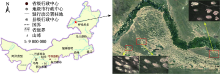
图1
研究区位置及风蚀坑分布特征 注:底图采用自然资源部标准地图制作,审图号为GS(2019)3333号,对底图边界无修改。"

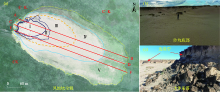
图2
风蚀坑土壤取样位置及局部地貌特征"

表1
风蚀坑参数特征"
| 风蚀坑编号 | 沙坑面积/hm2 | 沙坑最大深度/m | 沙坑宽度/m | 沙坑长度/m | 风蚀坑面积/hm2 |
|---|---|---|---|---|---|
| 1号 | 0.82 | 6.65 | 96.96 | 153.68 | 13.47 |
| 2号 | 1.02 | 10.25 | 109.61 | 188.18 | 21.72 |
| 3号 | 0.88 | 5.52 | 103.43 | 128.66 | 14.46 |
| 4号 | 0.65 | 7.78 | 60.92 | 101.65 | 4.57 |
| 5号 | 1.04 | 15.36 | 88.62 | 210.76 | 6.71 |
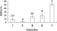
图3
风蚀坑典型部位面积占总面积的百分比 注:不同大写字母表示在P<0.05水平上风蚀坑不同部位面积比差异显著。"
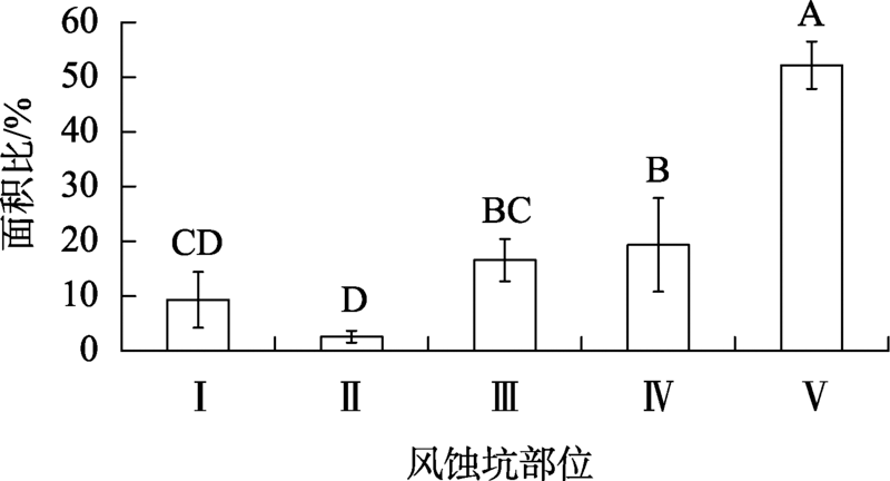
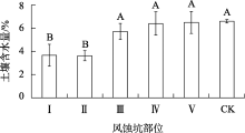
图4
风蚀坑及外部草地土壤含水量 注:不同大写字母表示在P<0.05水平上风蚀坑不同部位土壤含水量差异显著。"
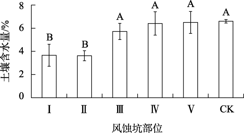
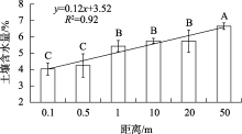
图5
风蚀坑边缘向外不同距离处土壤含水量变化 注:不同大写字母表示在P<0.05水平上风蚀坑边缘向外不同距离处土壤含水量变化差异显著。"

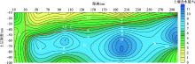
图6
距离风蚀坑边缘向外不同距离处土壤含水量等值线"
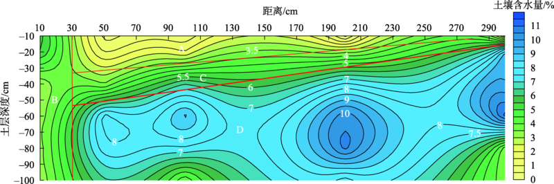
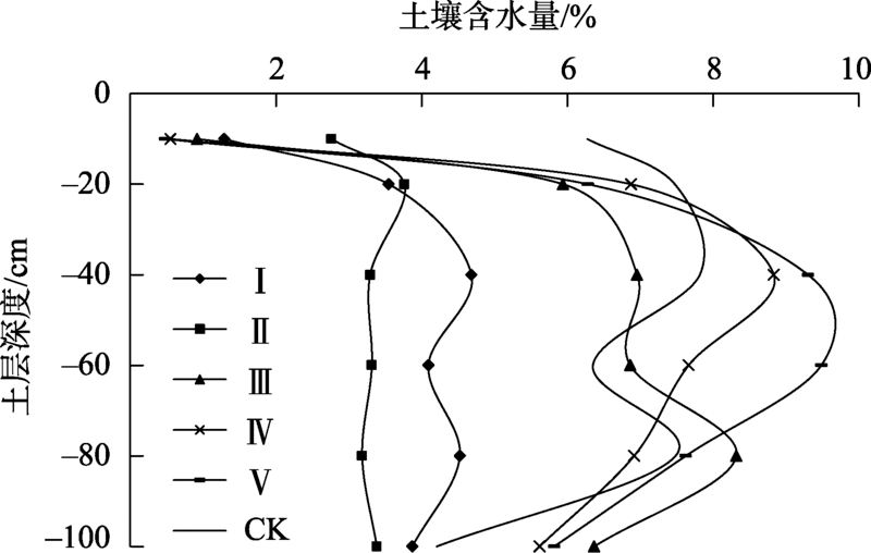
图7
风蚀坑典型部位剖面土壤含水量"
| [1] | 庄燕美, 哈斯. 沙丘风蚀坑的形态及动力过程的研究进展[J]. 干旱区地理, 2005, 28(5): 632-637. |
| [Zhuang Yanmei, Ha Si. Progress of the study on shapes and dynamical process of blowouts on dunes[J]. Arid Land Geography, 2005, 28(5): 632-637. ] | |
| [2] | 朱震达, 陈广庭. 中国土地沙质荒漠化[M]. 北京: 科学出版社, 1994. |
| [Zhu Zhenda, Chen Guangting. Sandy Desertification in China[M]. Beijing: Science Press, 1994. ] | |
| [3] |
孙禹, 杜会石, 刘美萍, 等. 风蚀坑形态-动力学研究进展[J]. 地理科学, 2015, 35(7): 898-904.
doi: 10.13249/j.cnki.sgs.2015.07.898 |
|
[Sun Yu, Du Huishi, Liu Meiping, et al. A review on morphodynamic processes of blowouts[J]. Scientia Geographica Sinica, 2015, 35(7): 898-904. ]
doi: 10.13249/j.cnki.sgs.2015.07.898 |
|
| [4] | 张德平, 王效科, 哈斯, 等. 呼伦贝尔沙质草原风蚀坑研究(1)-形态、分类、研究意义[J]. 中国沙漠, 2006, 26(6): 894-902. |
| [Zhang Deping, Wang Xiaoke, Ha Si, et al. HulunBuir sandy grassland blowouts(I): Geomorphology, classification, and significances[J]. Journal of Desert Research, 2006, 26(6): 894-902. ] | |
| [5] |
Sun Yu, Hasi Eerdun, Liu Meiping, et al. Airflow and sediment movement within an inland blowout in HulunBuir sandy grassland, Inner Mongolia, China[J]. Aeolian Research, 2016, 22: 13-22.
doi: 10.1016/j.aeolia.2016.05.002 |
| [6] |
闫德仁. 浑善达克沙地风蚀坑形态特征及其影响因素[J]. 地理科学, 2016, 36(4): 637-642.
doi: 10.13249/j.cnki.sgs.2016.04.019 |
|
[Yan Deren. Impact factors and morphological characteristics of blowouts in Hunshandake sand land[J]. Scientia Geographica Sinica, 2016, 36(4): 637-642. ]
doi: 10.13249/j.cnki.sgs.2016.04.019 |
|
| [7] |
孙禹, 杜会石, 哈斯额尔敦, 等. 固定沙丘风蚀坑风沙动力学观测研究[J]. 地理学报, 2016, 71(9): 1562-1570.
doi: 10.11821/dlxb201609008 |
|
[Sun Yu, Du Huishi, Hasi Eerdun, et al. Aeolian dynamical process of blowout on the fixed dune[J]. Acta Geographica Sinica, 2016, 71(9): 1562-1570. ]
doi: 10.11821/dlxb201609008 |
|
| [8] | 胡日娜, 哈斯额尔敦, 浩毕斯哈拉图, 等. 浑善达克沙地东南缘固定沙丘风蚀坑动态变化[J]. 中国沙漠, 2019, 39(1): 34-43. |
| [ Hurina, Hasi Eerdun, Haobisi Halatu, et al. Dynamic change s of blowouts on fixed sand dunes in the southeastern fringe of Otindag Sandy Land[J]. Journal of Desert Research, 2019, 39(1): 34-43. ] | |
| [9] |
Malakouti M J, Lewis D T, Stubbendieck J. Effect of grasses and soil properties on wind erosion in sand blowouts[J]. Journal of Range Management, 1978, 31(6): 417-420
doi: 10.2307/3897198 |
| [10] | 张德平, 孙宏伟, 王效科, 等. 呼伦贝尔沙质草原风蚀坑研究(Ⅱ):发育过程[J]. 中国沙漠, 2007, 27(1): 20-24, 170-171. |
| [Zhang Deping, Sun Hongwei, Wang Xiaoke, et al. HulunBuir sandy grassland blowouts(II): Process of development and landscape evolution[J]. Journal of Desert Research, 2007, 27(1): 20-24, 170-171. ] | |
| [11] | 阎旭, 张德平, 夏显东, 等. 呼伦贝尔沙质草原风蚀坑形态发育模式分析[J]. 中国沙漠, 2009, 29(2): 212-217. |
| [Yan Xu, Zhang Deping, Xia Xiandong, et al. Morphology and development model of blowouts in HulunBuir sandy grassland, China[J]. Journal of Desert Research, 2009, 29(2): 212-217. ] | |
| [12] |
Jungerius P D. A simulation model of blowout development[J]. Earth Surface Processes and Landforms, 1984, 9: 509-512.
doi: 10.1002/esp.3290090604 |
| [13] | Gares P A, Nordstrom K F. A cyclic model of foredune blowout evolution f or a leeward coast: Island Beach, NJ[J]. Annals of the Association of American Geographers, 1995, 85: 1-20. |
| [14] |
Hesp P A, Walker I J. Three-dimensional aeolian dynamics within a bowl blowout during offshore winds: Greenwich Dunes, Prince Edward Island,Canada[J]. Aeolian Research, 2011, 3: 389-399
doi: 10.1016/j.aeolia.2011.09.002 |
| [15] | 张德平, 王效科, 孙宏伟, 等. 呼伦贝尔沙质草原风蚀坑研究(Ⅳ)——人类活动的影响[J]. 中国沙漠, 2007, 27(2): 214-220. |
| [Zhang Deping, Wang Xiaoke, Sun Hongwei, et al. HulunBuir sandy grassland blowouts: Influence of human activities[J]. Journal of Desert Research, 2017, 27(2): 214-220. ] | |
| [16] | 周炎广, 陈惠中, 管超, 等. 呼伦贝尔沙地风蚀坑粒度特征及其环境意义[J]. 中国沙漠, 2018, 38(4): 724-733. |
| [Zhou Yanguang, Chen Huizhong, Guan Chao, et al. Grain size characteristics of the blowout and its environmental significance in the HulunBuir Sandy Land China[J]. Journal of Desert Research, 2018, 38(4): 724-733. ] | |
| [17] |
Du H S, Hasi E, Yang Y, et al. Landscape pattern change and driving force of blowout distribution in the HulunBuir Sandy Grassland[J]. Sciences in Cold and Arid Regions, 2012, 4(5): 431-438.
doi: 10.3724/SP.J.1226.2012.00431 |
| [18] | Smyth T A G, Jackson D W T, Cooper J A G. High resolution measured and modelled three-dimensional airflow over a coastal bowl blowout[J]. Geomorphology, 2012, 177-178: 62-73. |
| [19] | 王帅, 哈斯. 呼伦贝尔沙质草原区域风况及风蚀坑形态特征[J]. 水土保持研究, 2008, 15(3): 74-76. |
| [Wang Shuai, Ha Si. Wind regime and blowouts geomorphology in HulunBuir sandy grassland[J]. Science of Soil and Water Conservation, 2008, 15(3): 74-76. ] | |
| [20] | 李双权, 哈斯, 杜会石, 等. 沙质草地碟形风蚀坑形态-气流相互作用[J]. 中国沙漠, 2012, 32(5): 1201-1209. |
| [Li Shuangquan, Ha Si, Du Huishi, et al. Interaction between airflow and shape of saucer blowout in sandy grassland[J]. Journal of Desert Research, 2012, 32(5): 1201-1209. ] | |
| [21] | 王帅, 哈斯, 张军, 等. 呼伦贝尔沙质草原槽形风蚀坑表面气流及其意义[J]. 中国沙漠, 2007, 27(5): 745-749. |
| [Wang Shuai, Ha Si, Zhang Jun, et al. Geomorphological significance of air flow over saucer blowout of the HulunBuir sandy grassland[J]. Journal of Desert Research, 2007, 27(5): 745-749. ] | |
| [22] | 薛博, 袁立敏, 黄海广, 等. 沙障对风蚀坑种子库特征的影响研究[J]. 内蒙古林业科技, 2020, 46(3): 13-18. |
| [Xue Bo, Yuan Limin, Huang Haiguang, et al. Effects of sand barriers on characteristics of seed bank in blowout[J]. Journal of Inner Mongolia Forestry Science & Technology, 2020, 46(3): 13-18. ] | |
| [23] | 曲娜, 杜敏, 袁立敏, 等. 呼伦贝尔沙化风蚀坑生物工程治沙技术效果[J]. 内蒙古林业科技, 2013, 39(2): 25-27, 46. |
| [Qu Na, Du Min, Yuan Limin, et al. Effect of biological engineering on sand control in blowouts of HulunBuir[J]. Journal of Inner Mongolia Forestry Science & Technology, 2013, 39(2): 25-27, 46. ] | |
| [24] | 曲娜, 闫婷, 黄海广, 等. 活化风蚀坑沙障固沙技术及植被恢复[J]. 内蒙古林业科技, 2020, 46(1): 1-7. |
| [Qu Na, Yan Ting, Huang Haiguang, et al. Sand fixation technology and vegetation restoration of activated blowouts sand barrier[J]. Journal of Inner Mongolia Forestry Science & Technology, 2020, 46(1): 1-7. ] | |
| [25] | 黄海广, 闫德仁, 胡小龙, 等. 浑善达克沙地固定沙丘活化风蚀坑治理技术[J]. 内蒙古林业科技, 2018, 44(4): 18-24. |
| [Huang Haiguang, Yan Deren, Hu Xiaolong, et al. Treatment technology of fixed dune activated blowouts in Otindag Sandy Land[J]. Journal of Inner Mongolia Forestry Science & Technology, 2018, 44(4): 18-24. ] | |
| [26] | 闫德仁, 黄海广, 胡小龙, 等. 风蚀坑土壤风蚀控制与植被恢复技术[J]. 内蒙古林业科技, 2019, 45(1): 1-4, 33. |
| [Yan Deren, Huang Haiguang, Hu Xiaolong, et al. Techniques of soil wind erosion control and vegetation restoration in blowouts[J]. Journal of Inner Mongolia Forestry Science & Technology, 2019, 45(1): 1-4,33. ] | |
| [27] | 徐汝汝, 安庆, 赵启, 等. 柴达木盆地东缘风蚀坑不同位置风成沉积物粒度特征分析[J]. 成都师范学院学报, 2019, 35(9): 91-97. |
| [Xu Ruru, An Qing, Zhao Qi, et al. Grain size characteristics of aeolian sediments at different location of blowouts in the eastern margin of Qaidam Basin[J]. Journal of Chengdu Normal University, 2019, 35(9): 91-97. ] | |
| [28] | Fraser G S, Bennett S W, Olyphant, et al. Windflaw circulation patterns in a coastal dune blowout[J]. Journal of Coastal Research, 1998, 14(2): 451-460. |
| [29] | 张惜伟, 汪季, 高永, 等. 呼伦贝尔沙质草原风蚀坑表层土壤粒度特征[J]. 干旱区研究, 2017, 34(2): 293-299. |
| [Zhang Xiwei, Wang Ji, Gao Yong, et al. Characteristics of surface soil grain size in wind erosion pits in HulunBuir Sandy grassland[J]. Arid Zone Research, 2017, 34(2): 293-299. ] | |
| [30] | 王中原, 罗万银, 董治宝, 等. 共和盆地高寒草原风蚀坑表层沉积物粒度特征及动力学意义[J]. 中国沙漠, 2017, 37(1): 7-16. |
| [Wang Zhongyuan, Luo Wanyin, Dong Zhibao, et al. Grain size characteristics and dynamic significance of surface sediments in blowouts of alpine steppe in Gonghe Basin[J]. Journal of Desert Research, 2017, 37(1): 7-16. ] | |
| [31] | 刘小平, 董治宝. 湿沙的风蚀起动风速实验研究[J]. 水土保持通报, 2002, 22(2): 1-4. |
| [Liu Xiaoping, Dong Zhibao. Experimental study on wind erosion initiation of wet sand[J]. Bulletin of Soil and Water Conservation, 2002, 22(2): 1-4. ] | |
| [32] | 移小勇, 赵哈林, 赵学勇, 等. 不同风沙土含水量因子的抗风蚀性[J]. 土壤学报, 2006, 43(4): 684-687. |
| [Yi Xiaoyong, Zhao Halin, Zhao Xueyong, et al. Erodibility of aeolian soils in moisture content[J]. Acta Pedologica Sinica, 2006, 43(4): 684-687. ] | |
| [33] | 闫德仁. 呼伦贝尔沙地[M]. 呼和浩特: 内蒙古大学出版社, 2010. |
| [Yan Deren. HulunBuir Sandy Land[M]. Hohht: Inner Mongolia University Press, 2010. ] | |
| [34] | 张萍, 哈斯, 王帅, 等. 呼伦贝尔沙质草原风蚀坑积沙区的植被分带性[J]. 自然资源学报, 2008, 23(2): 237-244. |
| [Zhang Ping, Ha Si, Wang Shuai, et al. Zonation of vegetation on depositional area of blowout in HulunBuir Grassland[J]. Journal of Natural Resources, 2008, 23(2): 237-244. ] | |
| [35] | 林聪. 呼伦贝尔市近57年干燥度变化特征分析[J]. 新农业, 2020(22): 13-14. |
| [Lin Cong. Characteristics of dryness change in Hulunbuir in recent 57 years[J]. New Agriculture, 2020(22): 13-14. ] | |
| [36] | 王明莹. 呼伦贝尔天然草地野生菊科牧草资源及资源评价[J]. 东北农业大学学报, 2011, 42(4): 116-124. |
| [Wang Mingying. Wild composite herbage resources and resource evaluation in HulunBuir natural grassland[J]. Journal of Northeast Agricultural University, 2011, 42(4): 116-124. ] | |
| [37] | 张惜伟, 汪季, 高永, 等. 近15年呼伦贝尔沙质草原植被覆盖变化对气候因子的响应[J]. 草地学报, 2018, 26(1): 62-69. |
| [Zhang Xiwei, Wang Ji, Gao Yong, et al. Response of vegetation cover to climatic factors in HulunBuir Sandy in recent 15 years[J]. Acta Agrestia Sinica, 2018, 26(1):62-69. ] | |
| [38] |
张绍云, 董玉祥. 海岸沙地风蚀坑形态-动力学研究进展[J]. 地球科学进展, 2019, 34(10): 1028-1037.
doi: 10.11867/j.issn.1001-8166.2019.10.1028 |
|
[Zhang Shaoyun, Dong Yuxiang. Research progress on morph dynamics of coastal sandy blowout[J]. Advances in Earth Science, 2019, 34(10): 1028-1037. ]
doi: 10.11867/j.issn.1001-8166.2019.10.1028 |
|
| [39] |
Hesp P A, Walker I J. Three-dimensional aeolian dynamics within a bowl blowout during offshore winds: Greenwich Dunes, Prince Edward Island,Canada[J]. Aeolian Research, 2011, 3: 389-399.
doi: 10.1016/j.aeolia.2011.09.002 |
| [40] |
车雪华, 罗万银, 邵梅, 等. 青海共和盆地不同发育阶段风蚀坑表面气流场与形态反馈研究[J]. 地球科学进展, 2021, 36(1): 95-109.
doi: 10.11867/j.issn.1001-8166.2021.009 |
|
[Che Xuehua, Luo Wanyin, Shao Mei, et al. Form-flow feedback within blowouts at different developing stages in the Gonghe Basin, Qinghai Province[J]. Advances in Earth Science, 2021, 36(1): 95-109. ]
doi: 10.11867/j.issn.1001-8166.2021.009 |
|
| [41] |
Wu Gaolin, Lui Yu, Yang Zheng, et al. Root channels to indicate the increase in soil matrix water infiltration capacity of arid reclaimed mine soils[J]. Journal of Hydrology, 2017, 546: 133-139.
doi: 10.1016/j.jhydrol.2016.12.047 |
| [42] | 张璐, 朱仲元, 张圣微, 等. 半干旱草原型流域土壤水分变异及其影响因素分析[J]. 农业工程学报, 2020, 36(13): 124-132. |
| [Zhang Lu, Zhu Zhongyuan, Zhang Shengwei, et al. Analysis of soil moisture variation and its influencing factors in semi-arid steppe watershed[J]. Transactions of the Chinese Society of Agricultural Engineering, 2020, 36(13): 124-132. ] |
| [1] | 邱春霞, 刘晓宏, 李豆, 张佳淼, 李朋飞. 机载LiDAR和模糊推理系统在黄土高原土壤侵蚀监测中的应用[J]. 干旱区研究, 2024, 41(8): 1331-1342. |
| [2] | 万佳怡, 矢佳昱, 张华敏, 李兰晖, 丁明军. 三江源区不同覆被类型高寒草甸土壤水分变化特征[J]. 干旱区研究, 2024, 41(8): 1343-1353. |
| [3] | 郑柳娜, 江红南, 孙梦婷. 基于遥感影像的新疆渭干河—库车河三角洲土壤水盐与植被覆盖度的关系[J]. 干旱区研究, 2024, 41(7): 1131-1139. |
| [4] | 包志鑫, 袁立敏, 武红燕, 鲁海涛, 韩照日格图. 呼伦贝尔草原风蚀坑植物分布空间异质效应[J]. 干旱区研究, 2024, 41(7): 1185-1194. |
| [5] | 董彭蓓, 任宗萍, 李鹏, 王凯博, 贺国凯, 王璞. 土地利用变化下宁夏生态系统服务权衡协同关系研究[J]. 干旱区研究, 2024, 41(6): 1032-1044. |
| [6] | 王勃, 张建军, 赖宗锐, 赵炯昌, 胡亚伟, 杨周, 李阳, 卫朝阳. 土壤含水量对探地雷达探测植物根系构型精度的影响[J]. 干旱区研究, 2024, 41(3): 456-466. |
| [7] | 姚春艳, 刘洪鹄, 刘竞. 长江源区1980—2020年水沙变化规律[J]. 干旱区研究, 2023, 40(5): 726-736. |
| [8] | 石建周, 刘贤德, 田青, 于澎涛, 王彦辉. 六盘山半干旱区华北落叶松林坡面土壤含水量的降雨响应[J]. 干旱区研究, 2023, 40(4): 594-604. |
| [9] | 张雨斯, 包玉海, 贺忠华. 1990—2021年内蒙古遥感生态环境质量变化及趋势分析——以呼伦贝尔市陈巴尔虎旗为例[J]. 干旱区研究, 2023, 40(2): 326-336. |
| [10] | 郑欣如, 王树森, 王博, 张欣, 刘静, 胡晶华, 李诗文, 袁亚楠, 王丫博. 采煤沉陷区模拟土壤侵蚀胁迫对黑沙蒿生理生长特性的影响[J]. 干旱区研究, 2023, 40(11): 1806-1814. |
| [11] | 赵蒙恩,闫庆武,刘政婷,王文铭,李桂娥,吴振华. 鄂尔多斯市土壤侵蚀时空演变及影响因子分析[J]. 干旱区研究, 2022, 39(6): 1819-1831. |
| [12] | 杨慧,张泽,张兰,闫兴富. 柠条种子萌发对不同温度和土壤含水量的响应[J]. 干旱区研究, 2022, 39(6): 1875-1884. |
| [13] | 李泽厚,李蕊希,张舒斌,王崇斌,郑明明,董叶卿,吴雪. 多枝柽柳叶片结构和化学性状对土壤水分变化的响应[J]. 干旱区研究, 2022, 39(5): 1486-1495. |
| [14] | 王佳,田青,王理德,何洪盛,宋达成,郭春秀. 民勤青土湖区不同年限退耕地对土壤水分与物种多样性的影响[J]. 干旱区研究, 2022, 39(2): 605-614. |
| [15] | 宋良翠,马维伟,李广,龙永春,常文华. 水分对尕海湿地退化演替土壤氮矿化的影响[J]. 干旱区研究, 2022, 39(1): 165-175. |
|
||