干旱区研究 ›› 2022, Vol. 39 ›› Issue (5): 1385-1397.doi: 10.13866/j.azr.2022.05.05 cstr: 32277.14.AZR.20220505
王靖文1( ),唐志光1(),邓刚1,胡国杰2,桑国庆1
收稿日期:2022-03-15
修回日期:2022-06-14
出版日期:2022-09-15
发布日期:2022-10-25
作者简介:王靖文(1998-),男,硕士研究生,主要从事积雪遥感方面的研究. E-mail: 基金资助:
WANG Jingwen1(),TANG Zhiguang1(),DENG Gang1,HU Guojie2,SANG Guoqing1
Received:2022-03-15
Revised:2022-06-14
Published:2022-09-15
Online:2022-10-25
摘要:
研究融雪末期雪线高度变化有助于预测冰雪系统未来的变化趋势、理解区域和全球气候变化。基于Google Earth Engine(GEE)平台和Landsat卫星数据,发展了区域雪线高度提取模型,提取了天山4个子流域1991—2021年的融雪末期雪线高度,并分析了雪线高度的变化特征及其与气象因素的关系。结果表明:(1) Landsat提取的融雪末期雪线高度与Sentinel-2提取的融雪末期“最小化”积雪范围具有较高的一致性,其总体精度为91.6%,Kappa系数达0.9以上,利用该模型可准确获取融雪末期的区域雪线高度。(2) 研究区近30 a融雪末期雪线高度呈明显的上升趋势,上升速率介于2.7~6.4 m·a-1之间;其中,玛纳斯河流域雪线高度上升速度最快,阿克牙孜河流域雪线高度上升速度最慢。(3) 夏季气温是影响研究区融雪末期雪线高度变化的主要因素(P< 0.05),降水对其影响相对较弱。
王靖文,唐志光,邓刚,胡国杰,桑国庆. 1991—2021年天山融雪末期雪线高度遥感监测研究[J]. 干旱区研究, 2022, 39(5): 1385-1397.
WANG Jingwen,TANG Zhiguang,DENG Gang,HU Guojie,SANG Guoqing. Monitoring of snowline altitude at the end of melting season in Tianshan Mountains from 1991 to 2021[J]. Arid Zone Research, 2022, 39(5): 1385-1397.
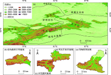
图1
研究区概况图"


图2
研究区域融雪期覆盖的影像数量"
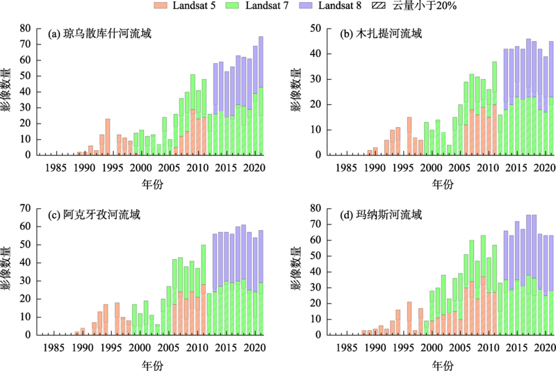
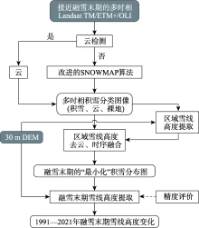
图3
总体技术路线"


图4
区域雪线高度提取示意图"
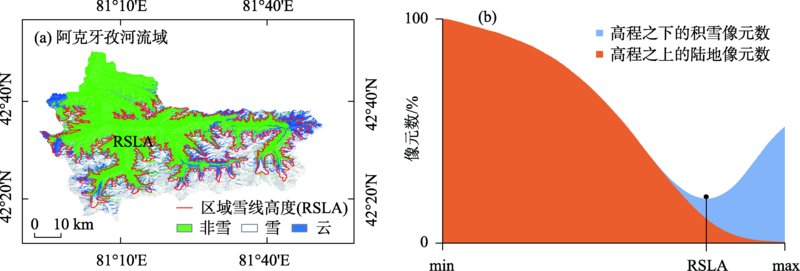
表1
研究区域Sentinel-2影像覆盖数量"
| 覆盖数量 | 分布时间/年-月-日 | |
|---|---|---|
| 琼乌散库什河流域 | 26 | 2019-06-01—2019-09-30 2020-06-01—2020-09-30 2021-06-01—2021-09-30 |
| 木扎提河流域 | 24 | 2019-06-01—2019-09-30 2020-06-01—2020-09-30 2021-06-01—2021-09-30 |
| 阿克牙孜河流域 | 26 | 2019-06-01—2019-09-30 2020-06-01—2020-09-30 2021-06-01—2021-09-30 |
| 玛纳斯河流域 | 24 | 2019-06-01—2019-09-30 2020-06-01—2020-09-30 2021-06-01—2021-09-30 |
表2
Landsat融雪末期雪线高度提取结果精度评价"
| 研究子区 | Sentinel-2提取的验证样本 | 精度指标 | ||
|---|---|---|---|---|
| 积雪/个数 | 非雪/个数 | |||
| 琼乌散库什河流域 | 高于Landsat提取雪线高度 | 291 | 76 | Pre=79.29% Rec=85.59% OA=87.5% Kappa=0.86 |
| 低于Landsat提取雪线高度 | 49 | 584 | ||
| 木扎提河流域 | 高于Landsat提取雪线高度 | 391 | 68 | Pre=85.19% Rec=96.07% OA=91.6% Kappa=0.90 |
| 低于Landsat提取雪线高度 | 16 | 525 | ||
| 阿克牙孜河流域 | 高于Landsat提取雪线高度 | 343 | 51 | Pre=87.06% Rec=93.97% OA=92.7% Kappa=0.92 |
| 低于Landsat提取雪线高度 | 22 | 584 | ||
| 玛纳斯河流域 | 高于Landsat提取雪线高度 | 406 | 34 | Pre=92.27% Rec=94.86% OA=94.4% Kappa=0.93 |
| 低于Landsat提取雪线高度 | 22 | 517 | ||

图5
6—9月雪线高度与平均积雪覆盖率变化"
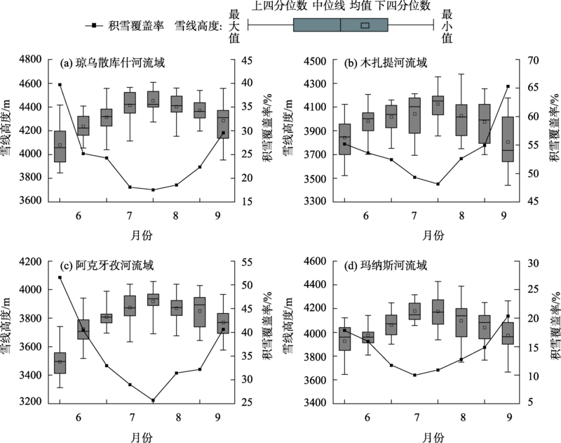
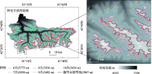
图6
瞬时雪线高度空间分布(以阿克牙孜河流域为例)"
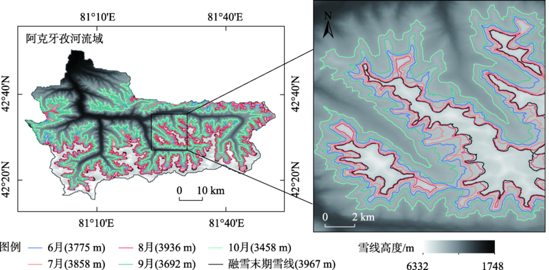
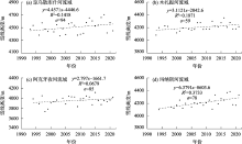
图7
融雪末期雪线高度年际变化 注:由于云层遮挡和影像缺失等原因,有些年份获取不到融雪末期雪线高度。"

表3
融雪末期雪线高度与气温、降水量之间的相关性"
| 夏季气温相关性 | 年气温相关性 | 夏季降水量相关性 | 年降水量相关性 | |
|---|---|---|---|---|
| 琼乌散库什河流域 | 0.485 | 0.352 | -0.105 | -0.221 |
| 木扎提河流域 | 0.558** | 0.451* | -0.232 | -0.133 |
| 阿克牙孜河流域 | 0.503** | 0.361 | -0.136 | -0.321 |
| 玛纳斯河流域 | 0.391* | 0.366 | -0.322 | -0.371 |
图8
融雪末期雪线高度与气温和降水量的年际变化"
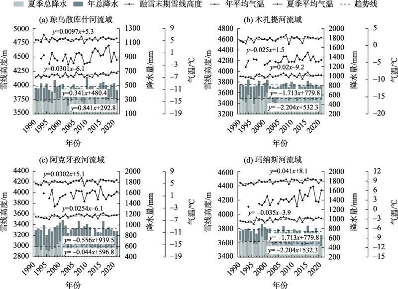
表4
融雪末期雪线高度回归模型系数"
| 回归因子系数 | 相关系数(R) | 显著性水平 | |||
|---|---|---|---|---|---|
| λ | a | b | |||
| 琼乌散库什河流域 | 4220 | 82.9 | 0.355 | 0.515 | P< 0.05 |
| 木扎提河流域 | 4294 | 50.7 | 0.238 | 0.559 | P< 0.01 |
| 阿克牙孜河流域 | 4040 | 76.2 | 0.287 | 0.548 | P< 0.01 |
| 玛纳斯河流域 | 4009 | 62.4 | 0.364 | 0.520 | P< 0.05 |
| [1] | Licker M D. Dictionary of Earth Science[M]. New York: McGraw-Hill, 2003. |
| [2] |
Mengel J, Short D, North G. Seasonal snowline instability in an energy balance model[J]. Climate Dynamics, 1988, 2(3): 127-131.
doi: 10.1007/BF01053470 |
| [3] |
Baum S K, Crowley T J. Seasonal snowline instability in a climate model with realistic geography: Application to carboniferous (∼300 MA) glaciation[J]. Geophysical Research Letters, 1991, 18(9): 1719-1722.
doi: 10.1029/91GL01723 |
| [4] | 谢自楚, 刘潮海. 冰川学导论[M]. 上海: 上海科学普及出版社, 2010. |
| [Xie Zichu, Liu Chaohai. Leading Principles of Glaciology[M]. Shanghai: Shanghai Popular Science Press, 2010. ] | |
| [5] | 秦大河, 姚檀栋, 丁永建. 冰冻圈科学辞典[M]. 北京: 气象出版社, 2014. |
| [Qin Dahe, Yao Tandong, Ding Yongjian. Glossary of Cryospheric Science[M]. Beijing: China Meteorological Press, 2014. ] | |
| [6] |
Pandey P, Kulkarni A V, Venkataraman G. Remote sensing study of snowline altitude at the end of melting season, Chandra-Bhaga basin, Himachal Pradesh, 1980-2007[J]. Geocarto International, 2013, 28(4): 311-322.
doi: 10.1080/10106049.2012.705336 |
| [7] | Flint R F. Glacial and Quaternary geology[M]. New York: John Wiley Press, 1971. |
| [8] |
Rabatel A, Bermejo A, Loarte E, et al. Can the snowline be used as an indicator of the equilibrium line and mass balance for glaciers in the outer tropics?[J]. Journal of Glaciology, 2012, 58(212): 1027-1036.
doi: 10.3189/2012JoG12J027 |
| [9] | 郭忠明, 顾祝军, 吴红波, 等. 冰川雪线高度研究进展[J]. 遥感技术与应用, 2016, 31(4): 645-652. |
| [Guo Zhongming, Gu Zhujun, Wu Hongbo, et al. Research progress of glacier snowline altitude[J]. Remote Sensing Technology and Application, 2016, 31(4): 645-652. ] | |
| [10] |
Shea J, Menounos B, Moore R, et al. An approach to derive regional snow lines and glacier mass change from MODIS imagery, western North America[J]. The Cryosphere, 2013, 7(2): 667-680.
doi: 10.5194/tc-7-667-2013 |
| [11] |
Barandun M, Huss M, Usubaliev R, et al. Multi-decadal mass balance series of three Kyrgyz glaciers inferred from modelling constrained with repeated snow line observations[J]. The Cryosphere, 2018, 12(6): 1899-1919.
doi: 10.5194/tc-12-1899-2018 |
| [12] |
McFadden E, Ramage J, Rodbell D. Landsat TM and ETM+ derived snowline altitudes in the Cordillera Huayhuash and Cordillera Raura, Peru, 1986-2005[J]. The Cryosphere, 2011, 5(2): 419-430.
doi: 10.5194/tc-5-419-2011 |
| [13] | 车涛, 李新, 李新武, 等. 冰冻圈遥感: 助力“三极”大科学计划[J]. 中国科学院院刊, 2020, 35(4): 484-493. |
| [Che Tao, Li Xin, Li Xinwu, et al. Developing cryospheric remote sensing, poromoting scientific programme of Earth’s Three Poles[J]. Bulletin of Chinese Academy of Sciences, 2020, 35(4): 484-493. ] | |
| [14] |
Guo H, Li X, Qiu Y. Comparison of global change at the earth’s three poles using spaceborne earth observation[J]. Science Bulletin, 2020, 65(16): 1320-1323.
doi: 10.1016/j.scib.2020.04.031 |
| [15] | Notarnicola C. Hotspots of snow cover changes in global mountain regions over 2000-2018[J]. Remote Sensing of Environment, 2020, 243: 111781. |
| [16] |
Verbyla D, Hegel T, Nolin A W, et al. Remote sensing of 2000-2016 alpine spring snowline elevation in dall sheep mountain ranges of Alaska and Western Canada[J]. Remote Sensing, 2017, 9(11): 1157.
doi: 10.3390/rs9111157 |
| [17] |
Spiess M, Huintjes E, Schneider C. Comparison of modelled-and remote sensing-derived daily snow line altitudes at Ulugh Muztagh, northern Tibetan Plateau[J]. Journal of Mountain Science, 2016, 13(4): 593-613.
doi: 10.1007/s11629-015-3818-x |
| [18] |
Krajčí P, Holko L, Perdigão R A, et al. Estimation of regional snowline elevation (RSLE) from MODIS images for seasonally snow covered mountain basins[J]. Journal of Hydrology, 2014, 519: 1769-1778.
doi: 10.1016/j.jhydrol.2014.08.064 |
| [19] | Tang Z, Wang J, Li H, et al. Extraction and assessment of snowline altitude over the Tibetan plateau using MODIS fractional snow cover data (2001 to 2013)[J]. Journal of Applied Remote Sensing, 2014, 8(1): 084689. |
| [20] |
Tang Z, Wang X, Deng G, et al. Spatiotemporal variation of snowline altitude at the end of melting season across high mountain Asia, using MODIS snow cover product[J]. Advances in Space Research, 2020, 66(11): 2629-2645.
doi: 10.1016/j.asr.2020.09.035 |
| [21] |
Girona-Mata M, Miles E S, Ragettli S, et al. High-resolution snowline delineation from Landsat imagery to infer snow cover controls in a Himalayan catchment[J]. Water Resources Research, 2019, 55(8): 6754-6772.
doi: 10.1029/2019WR024935 |
| [22] |
Hu Z, Dietz A, Kuenzer C. The potential of retrieving snow line dynamics from Landsat during the end of the ablation seasons between 1982 and 2017 in European mountains[J]. International Journal of Applied Earth Observation and Geoinformation, 2019, 78: 138-148.
doi: 10.1016/j.jag.2019.01.010 |
| [23] |
Guo Z, Wang N, Wu H, et al. Variations in firn line altitude and firn zone area on Qiyi Glacier, Qilian Mountains, over the period of 1990 to 2011[J]. Arctic, Antarctic, and Alpine Research, 2015, 47(2): 293-300.
doi: 10.1657/AAAR00C-13-303 |
| [24] |
张其兵, 康世昌, 张国帅, 等. 念青唐古拉山脉西段雪线高度变化遥感观测[J]. 地理科学, 2016, 36(12): 1937-1944.
doi: 10.13249/j.cnki.sgs.2016.12.020 |
|
[Zhang Qibing, Kang Shichang, Zhang Guoshuai, et al. Changes of snow line altitude for glaciers on western Nyainqentanglha range observed by remote sensing[J]. Scientia Geographica Sinica, 2016, 36(12): 1937-1944. ]
doi: 10.13249/j.cnki.sgs.2016.12.020 |
|
| [25] | 付东杰, 肖寒, 苏奋振, 等. 遥感云计算平台发展及地球科学应用[J]. 遥感学报, 2021, 25(1): 220-230. |
| [Fu Dongjie, Xiao Han, Su Fenzhen, et al. Remote sensing cloud computing plat form development and earth science application[J]. National Remote Sensing Bulletin, 2021, 25(1): 220-230. ] | |
| [26] |
Wayand N E, Marsh C B, Shea J M, et al. Globally scalable alpine snow metrics[J]. Remote Sensing of Environment, 2018, 213: 61-72.
doi: 10.1016/j.rse.2018.05.012 |
| [27] | 刘畅, 李震, 张平, 等. 基于Google Earth Engine评估新疆西南部 MODIS 积雪产品[J]. 遥感技术与应用, 2018, 33(4): 584-592. |
| [Liu Chang, Li Zhen, Zhang Ping, et al. Evaluation of MODIS snow products in southwestern Xinjiang using the Google Earth Engine[J]. Remote Sensing Technology and Application, 2018, 33(4): 584-592. ] | |
| [28] |
Crumley R L, Palomaki R T, Nolin A W, et al. Snow cloud metrics: snow information for everyone[J]. Remote Sensing, 2020, 12(20): 3341.
doi: 10.3390/rs12203341 |
| [29] |
Sorg A, Bolch T, Stoffel M, et al. Climate change impacts on glaciers and runoff in Tien Shan(Central Asia)[J]. Nature Climate Change, 2012, 2(10): 725-731.
doi: 10.1038/nclimate1592 |
| [30] |
Xu M, Kang S, Wu H, et al. Detection of spatio-temporal variability of air temperature and precipitation based on long-term meteorological station observations over Tianshan Mountains, Central Asia[J]. Atmospheric research, 2018, 203: 141-163.
doi: 10.1016/j.atmosres.2017.12.007 |
| [31] |
陈亚宁, 李稚, 方功焕, 等. 气候变化对中亚天山山区水资源影响研究[J]. 地理学报, 2017, 72(1): 18-26.
doi: 10.11821/dlxb201701002 |
|
[Chen Yaning, Li Zhi, Fang Gonghuan, et al. Impact of climate change on water resources in the Tianshan Mountians, Central Asia[J]. Acta Geographica Sinica, 2017, 72(1): 18-26. ]
doi: 10.11821/dlxb201701002 |
|
| [32] |
Li P, Li Z, Muller J-P, et al. A new quality validation of global digital elevation models freely available in China[J]. Survey Review, 2016, 48(351): 409-420.
doi: 10.1179/1752270615Y.0000000039 |
| [33] |
Hall D K, Riggs G A, Salomonson V V. Development of methods for mapping global snow cover using moderate resolution imaging spectroradiometer data[J]. Remote Sensing of Environment, 1995, 54(2): 127-140.
doi: 10.1016/0034-4257(95)00137-P |
| [34] | Zhang H, Zhang F, Zhang G, et al. Enhanced scaling effects significantly lower the ability of MODIS normalized difference snow index to estimate fractional and binary snow cover on the Tibetan Plateau[J]. Journal of Hydrology, 2021, 592: 125795. |
| [35] |
Xiao P, Li C, Zhu L, et al. Multitemporal ensemble learning for snow cover extraction from high-spatial-resolution images in mountain areas[J]. International Journal of Remote Sensing, 2020, 41(5): 1668-1691.
doi: 10.1080/01431161.2019.1674458 |
| [36] |
Negi H S, Kulkarni A, Semwal B. Estimation of snow cover distribution in Beas basin, Indian Himalaya using satellite data and ground measurements[J]. Journal of Earth System Science, 2009, 118(5): 525-538.
doi: 10.1007/s12040-009-0039-0 |
| [37] |
Wang X, Chen S, Wang J. An adaptive snow identification algorithm in the forests of northeast China[J]. IEEE Journal of Selected Topics in Applied Earth Observations and Remote Sensing, 2020, 13: 5211-5222.
doi: 10.1109/JSTARS.2020.3020168 |
| [38] |
Wang X, Wang J, Che T, et al. Snow cover mapping for complex mountainous forested environments based on a multi-index technique[J]. IEEE Journal of Selected Topics in Applied Earth Observations and Remote Sensing, 2018, 11(5): 1433-1441.
doi: 10.1109/JSTARS.2018.2810094 |
| [39] | Liu C, Li Z, Zhang P, et al. Variability of the snowline altitude in the eastern Tibetan Plateau from 1995 to 2016 using Google Earth Engine[J]. Journal of Applied Remote Sensing, 2021, 15(4): 048505. |
| [40] |
Li X, Wang N, Wu Y. Automated glacier snow line altitude calculation method using Landsat series images in the Google Earth Engine platform[J]. Remote Sensing, 2022, 14(10): 2377.
doi: 10.3390/rs14102377 |
| [41] | 唐志光, 王建, 梁继, 等. 基于MODIS的青藏高原雪线高度遥感监测[J]. 遥感技术与应用, 2015, 30(4): 767-774. |
| [Tang Zhiguang, Wang Jian, Liang Ji, et al. Monitoring of snowline altitude over the Tibetan Plateau based on MODIS data[J]. Remote Sensing Technology and Application, 2015, 30(4): 767-774. ] | |
| [42] |
Deng G, Tang Z, Hu G, et al. Spatiotemporal dynamics of snowline altitude and their responses to climate change in the Tienshan Mountains, Central Asia, during 2001-2019[J]. Sustainability, 2021, 13(7): 3992.
doi: 10.3390/su13073992 |
| [43] |
邓海军, 陈亚宁. 中亚天山山区冰雪变化及其对区域水资源的影响[J]. 地理学报, 2018, 73(7): 1309-1323.
doi: 10.11821/dlxb201807010 |
|
[Deng Haijun, Chen Yaning. The glacier and snow variation and their impact on water resources in mountain region: A case study in Tianshan Mountains of Central Asia[J]. Acta Geographica Sinsca, 2018, 73(7): 1309-1323. ]
doi: 10.11821/dlxb201807010 |
|
| [44] | 张连成, 胡列群, 李帅, 等. 基于GIS的天山南北坡雪线分布特征及其影响因素分析[J]. 水土保持研究, 2015, 22(3): 259-263. |
| [Zhang Liancheng, Hu Liequn, Li Shuai, et al. GIS-based analysis on the snowline distributional characteristics of South and North slopes of Tianshan Mountain and their influencing factors[J]. Research of Soil and Water Conservation, 2015, 22(3): 259-263. ] | |
| [45] |
Dai Xingang, Li Weijing, Ma Zhuguo, et al. Water-vapor source shift of Xinjiang region during the recent twenty years[J]. Progress in Natural Science, 2007, 17(5): 569-575.
doi: 10.1080/10020070708541037 |
| [46] | 王圣杰, 张明军, 李忠勤, 等. 近50年来中国天山冰川面积变化对气候的响应[J]. 地理学报, 2011, 66(1): 38-46. |
| [Wang Shengjie, Zhang Mingjun, Li Zhongqin, et al. Response of glacier area variation to climate change in Chinese Tianshan Mountains in the past 50 years[J]. Acta Geographica Sinsca, 2011, 66(1): 38-46. ] | |
| [47] | 陈安安, 陈伟, 吴红波, 等. 2000-2013年木孜塔格冰鳞川冰川粒雪线高度变化研究[J]. 冰川冻土, 2014, 36(5): 1069-1078. |
| [Chen An’an, Chen Wei, Wu Hongbo, et al. The variations of firn line altitude on the Binglinchuan Glacier, Ulugh Muztagh during 2000-2013[J]. Journal of Glaciology and Geocryology, 2014, 36(5): 1069-1078. ] | |
| [48] | 王宁练. 冰川平衡线变化的主导气候因子灰色关联分析[J]. 冰川冻土, 2012, 17(1): 8-15. |
| [Wang Ninglian. Grey relational analysis of the leading climatic factor influencing the changes of the equilibrium line[J]. Journal of Glaciology and Geocryology, 1995, 17(1): 8-15. ] |
| [1] | 张彬, 郑新军, 王玉刚, 唐立松, 李彦, 杜澜, 田胜川. 1990—2022年天山北坡地区不同开垦年限耕层土壤盐分变化[J]. 干旱区研究, 2024, 41(9): 1435-1445. |
| [2] | 李宇航, 余文学, 杨永均, 朱燕峰, 马静, 陈浮. 近60 a天山北坡经济带天然径流量时空变化及归因识别[J]. 干旱区研究, 2024, 41(9): 1446-1455. |
| [3] | 吕壮壮, 乔庆庆, 董孙艺, 汪冬. 中中新世气候适宜期全球变暖背景下亚洲内陆干旱区古气候演化特征及驱动机制[J]. 干旱区研究, 2024, 41(8): 1309-1322. |
| [4] | 王怡雯, 马瑶瑶, 史培军, 张钢锋. 干旱区光伏电站运营对局地生态环境的影响[J]. 干旱区研究, 2024, 41(8): 1423-1433. |
| [5] | 周杰, 王旭虎, 杜维波, 周晓雷, 杨洁, 张晓玮. 气候变化背景下的天山云杉潜在分布区预测[J]. 干旱区研究, 2024, 41(7): 1167-1176. |
| [6] | 张顺鑫, 吴子豪, 闫庆武, 李桂娥, 牟守国. 基于PLUS-InVEST模型的天山北坡生态系统碳储量时空变化与预测[J]. 干旱区研究, 2024, 41(7): 1228-1237. |
| [7] | 马元植, 覃小林, 凌红波, 闫俊杰, 张广朋. 1991—2020年新疆中小湖泊面积变化时空特征及趋势分析[J]. 干旱区研究, 2024, 41(6): 905-916. |
| [8] | 梁双河, 牛最荣, 贾玲. 祖厉河干流近65 a径流变化及归因分析[J]. 干旱区研究, 2024, 41(6): 928-939. |
| [9] | 唐可欣, 郭建斌, 何亮, 陈林, 万龙. 中国旱区GPP时空演变特征及影响因素研究[J]. 干旱区研究, 2024, 41(6): 964-973. |
| [10] | 张嘉琪, 刘招, 韩忠青, 王丽霞, 张晋霞, 岳甲寅, 管子隆. 气候变化下泾河流域蓝绿水变化趋势及预测[J]. 干旱区研究, 2024, 41(12): 2045-2055. |
| [11] | 张倩, 曹广超, 张乐乐, 赵美亮. 祁连山南坡植被绿度时空变化及其对气候变化和人类活动的响应[J]. 干旱区研究, 2024, 41(12): 2143-2153. |
| [12] | 胡广录, 樊亚仑, 陶虎, 李昊辰, 杨鹏华. 石羊河下游蔡旗站径流变化趋势及影响因素[J]. 干旱区研究, 2024, 41(11): 1842-1852. |
| [13] | 杨斐, 张文韬, 张飞民, 王澄海. 1961—2022年祁连山气候特征及其变化[J]. 干旱区研究, 2024, 41(10): 1627-1638. |
| [14] | 张音, 孙从建, 刘庚, 钞锦龙, 耿甜伟. 近20 a塔里木河流域山区NDSI对气候变化的响应[J]. 干旱区研究, 2024, 41(10): 1639-1648. |
| [15] | 程倩, 齐月, 刘明春, 张鹏, 丁文魁, 李兴宇, 任丽雯, 杨华. 气候变化及人类活动背景下石羊河流域生态与水资源变化特征[J]. 干旱区研究, 2024, 41(10): 1672-1684. |
|
||