干旱区研究 ›› 2022, Vol. 39 ›› Issue (5): 1333-1344.doi: 10.13866/j.azr.2022.05.01 cstr: 32277.14.AZR.20220501
安彬1,2( ),肖薇薇1,2,朱妮1,2,刘宇峰3
收稿日期:2022-04-11
修回日期:2022-05-22
出版日期:2022-09-15
发布日期:2022-10-25
作者简介:安彬(1988-),男,副教授,研究方向为区域环境与GIS应用. E-mail: 基金资助:
AN Bin1,2(),XIAO Weiwei1,2,ZHU Ni1,2,LIU Yufeng3
Received:2022-04-11
Revised:2022-05-22
Published:2022-09-15
Online:2022-10-25
摘要:
全球气候变暖背景下,厘清黄土高原地区降水集中度(PCD)和集中期(PCP)时空变化规律,对该区水土保持及水资源利用具有重要意义。基于1960—2019年黄土高原地区55个气象站点逐日降水观测资料,利用趋势分析、空间插值、相关分析等方法,分析了近60 a及退耕还林(草)工程前后黄土高原PCD与PCP时空变化特征。结果表明:(1) 1960—2019年黄土高原年均降水量呈减少趋势,年均PCD逐渐减弱、PCP逐渐提前。(2) 黄土高原地区年均降水量和PCD自东南向西北递减,PCP自东向西逐渐递减,但差异不大。PCD变化趋势自东北向西南呈“下降-上升-下降”相间分布,PCP表现出东部推迟、西部提前的态势。(3) 退耕还林(草)工程后,黄土高原年均降水量增加、PCD减弱、PCP推迟。降水量自东向西呈“偏少-偏多”相间分布,其变化趋势以偏多为主;PCD自东北向西南呈“偏低-偏高-偏低”分布规律,其变化趋势以偏低为主;PCP以偏高为主,偏高幅度呈南多北少、东多西少态势,其趋势变化也以偏多为主。(4) 1960—2019年黄土高原地区PCD、PCP与年降水量皆以正相关为主。
安彬,肖薇薇,朱妮,刘宇峰. 近60 a黄土高原地区降水集中度与集中期时空变化特征[J]. 干旱区研究, 2022, 39(5): 1333-1344.
AN Bin,XIAO Weiwei,ZHU Ni,LIU Yufeng. Temporal and spatial variations of precipitation concentration degree and precipitation concentration period on the Loess Plateau from 1960 to 2019[J]. Arid Zone Research, 2022, 39(5): 1333-1344.
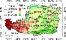
图1
黄土高原生态分区及气象站分布"
表1
退耕还林(草)前后黄土高原降水量变化"
| 区域 | 降水量均值/mm | 降水量变化趋势/(mm·a-1) | |||||||||||
|---|---|---|---|---|---|---|---|---|---|---|---|---|---|
| 1960s | 1970s | 1980s | 1990s | 2000s | 2010s | T时段 | T1时段 | T2时段 | T时段 | T1时段 | T2时段 | ||
| 全区 | 449.88 | 423.89 | 409.67 | 399.83 | 405.50 | 450.77 | 422.76 | 420.82 | 426.63 | -0.148 | -1.478 | 4.350 | |
| 高塬沟壑区(A) | 442.98 | 416.97 | 398.07 | 400.56 | 398.52 | 449.95 | 417.84 | 414.64 | 424.23 | 0.021 | -1.268 | 4.956 | |
| 丘陵沟壑区(B) | 494.52 | 445.56 | 432.04 | 426.45 | 433.34 | 509.28 | 456.86 | 449.64 | 471.31 | 0.186 | -1.849 | 6.826 | |
| 沙地农灌区(C) | 321.24 | 308.72 | 281.62 | 290.48 | 284.05 | 331.45 | 302.93 | 300.52 | 307.75 | 0.033 | -0.992 | 4.477 | |
| 土石河谷区(D) | 561.98 | 537.89 | 545.04 | 490.03 | 508.01 | 533.79 | 529.46 | 533.74 | 520.90 | -0.855 | -2.119 | 1.562 | |

图2
黄土高原1960—2019年降水量(a)及其变异系数(b)、退耕还林(草)前后降水量(c)及其变化趋势(d)空间分布"

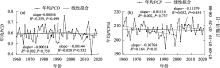
图3
1960—2019年黄土高原降水集中度(a)和集中期(b)时间变化"

表2
退耕还林(草)前后黄土高原降水集中度变化"
| 区域 | PCD均值 | PCD变化趋势/(10a)-1 | |||||||||||
|---|---|---|---|---|---|---|---|---|---|---|---|---|---|
| 1960s | 1970s | 1980s | 1990s | 2000s | 2010s | T时段 | T1时段 | T2时段 | T时段 | T1时段 | T2时段 | ||
| 全区 | 0.588 | 0.603 | 0.607 | 0.598 | 0.591 | 0.585 | 0.595 | 0.599 | 0.588 | -0.0014 | 0.0056 | -0.0144 | |
| 高塬沟壑区(A) | 0.597 | 0.609 | 0.606 | 0.628 | 0.608 | 0.589 | 0.606 | 0.610 | 0.599 | -0.0001 | 0.0106 | -0.0185 | |
| 丘陵沟壑区(B) | 0.635 | 0.645 | 0.651 | 0.626 | 0.617 | 0.614 | 0.631 | 0.640 | 0.615 | -0.0053 | 0.0006 | -0.0025 | |
| 沙地农灌区(C) | 0.641 | 0.680 | 0.652 | 0.659 | 0.655 | 0.623 | 0.652 | 0.658 | 0.639 | -0.0031 | 0.0074 | -0.0292 | |
| 土石河谷区(D) | 0.554 | 0.572 | 0.589 | 0.532 | 0.562 | 0.567 | 0.563 | 0.562 | 0.565 | -0.0015 | -0.0047 | -0.0202 | |
表3
退耕还林(草)前后黄土高原降水集中期变化"
| 区域 | PCP均值/d | PCP变化趋势/[d·(10a)-1] | |||||||||||
|---|---|---|---|---|---|---|---|---|---|---|---|---|---|
| 1960s | 1970s | 1980s | 1990s | 2000s | 2010s | T时段 | T1时段 | T2时段 | T时段 | T1时段 | T2时段 | ||
| 全区 | 208.80 | 208.20 | 205.30 | 204.00 | 209.00 | 208.00 | 207.22 | 206.58 | 208.50 | -0.111 | -1.676 | -1.158 | |
| 高塬沟壑区(A) | 208.08 | 207.13 | 204.19 | 203.26 | 208.12 | 206.66 | 206.24 | 205.67 | 207.39 | -0.168 | -1.743 | -0.951 | |
| 丘陵沟壑区(B) | 208.33 | 209.04 | 204.95 | 204.95 | 209.30 | 208.58 | 207.52 | 206.82 | 208.94 | 0.085 | -1.247 | -0.494 | |
| 沙地农灌区(C) | 208.55 | 210.01 | 205.49 | 204.58 | 209.13 | 209.08 | 207.81 | 207.16 | 209.11 | -0.043 | -1.597 | -0.100 | |
| 土石河谷区(D) | 208.95 | 207.73 | 206.37 | 203.88 | 209.93 | 208.24 | 207.51 | 206.73 | 209.09 | -0.044 | -1.577 | -2.716 | |
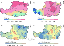
图4
黄土高原年均降水集中度(a)和集中期(b)及其变化趋势(c、d)空间分布"

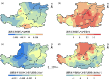
图5
退耕还林(草)前后黄土高原降水集中度(a)、集中期(b)及变化趋势(c、d)的变化空间分布"


图6
黄土高原降水量与降水集中度(a)和集中期(b)相关系数的空间分布"
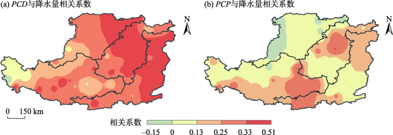
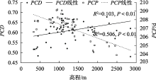
图7
黄土高原55个气象站点的降水集中度和集中期与高程的散点图"

| [1] | 周波涛. 全球气候变暖: 浅谈从AR5到AR6的认知进展[J]. 大气科学学报, 2021, 44(5): 667-671. |
| [Zhou Botao. Global warming: Scientific progress from AR5 to AR6[J]. Transactions of Atmospheric Sciences, 2021, 44(5): 667-671. ] | |
| [2] | IPCC. Climate Change 2021: The Physical Science Basis[M]. Cambridge: Cambridge University Press, 2021. |
| [3] | 樊星, 秦圆圆, 高翔. IPCC第六次评估报告第一工作组报告主要结论解读及建议[J]. 环境保护, 2021, 49(Z2): 44-48. |
| [Fan Xing, Qin Yuanyuan, Gao Xiang. Interpretation of the main conclusions and suggestions of IPCC AR6 Working Group I Report[J]. Environmental Protection, 2021, 49(Z2): 44-48. ] | |
| [4] | 孔锋. 透视大尺度综合自然灾害风险评估的主要进展和展望[J]. 灾害学, 2020, 35(2): 148-153. |
| [Kong Feng. Perspective on the main progress and prospect of large-scale integrated natural disaster risk assessment[J]. Journal of Catastrophology, 2020, 35(2): 148-153. ] | |
| [5] | 黄萌田, 周佰铨, 翟盘茂. 极端天气气候事件变化对荒漠化、土地退化和粮食安全的影响[J]. 气候变化研究进展, 2020, 16(1): 17-27. |
| [Huang Mengtian, Zhou Baiquan, Zhai Panmao. Impacts of extreme weather and climate events on desertification, land degradation and food security[J]. Climate Change Research, 2020, 16(1): 17-27. ] | |
| [6] |
Held I M, Soden B J. Robust responses of the hydrological cycle to global warming[J]. Journal of Climate, 2006, 19(21): 5686-5699.
doi: 10.1175/JCLI3990.1 |
| [7] |
谢正辉, 陈思, 秦佩华, 等. 人类用水活动的气候反馈及其对陆地水循环的影响研究——进展与挑战[J]. 地球科学进展, 2019, 34(8): 801-813.
doi: 10.11867/j.issn.1001-8166.2019.08.0801 |
|
[Xie Zhenghui, Chen Si, Qin Peihua, et al. Research on climate feedback of human water use and its impact on terrestrial water cycles: Advances and challenges[J]. Advances in Earth Science, 2019, 34(8): 801-813. ]
doi: 10.11867/j.issn.1001-8166.2019.08.0801 |
|
| [8] | 苏爱芳, 吕晓娜, 崔丽曼, 等. 郑州“7.20”极端暴雨天气的基本观测分析[J]. 暴雨灾害, 2021, 40(5): 445-454. |
| [Su Aifang, Lyu Xiao’na, Cui Liman, et al. The basic observational analysis of “7.20”extreme rainstorm in Zhengzhou[J]. Torrential Rain and Disasters, 2021, 40(5): 445-454. ] | |
| [9] | 郑炎辉, 陈晓宏, 何艳虎, 等. 珠江流域降水集中度时空变化特征及成因分析[J]. 水文, 2016, 36(5): 22-28. |
| [Zheng Yanhui, Chen Xiaohong, He Yanhu, et al. Spatial-temporal variation of precipitation concentration degree in Pearl River Basin and its causes[J]. Journal of China Hydrology, 2016, 36(5): 22-28. ] | |
| [10] | 孔锋, 方佳毅, 刘凡, 等. 1951—2012年中国降水集中度和集中期的时空格局[J]. 北京师范大学学报(自然科学版), 2015, 51(4): 404-411. |
| [Kong Feng, Fang Jiayi, Liu Fan, et al. Variations in the spatiotemporal patterns of precipitation concentration degree and precipitation concentration period from 1951 to 2012 in China[J]. Journal of Beijing Normal University (Natural Science Edition), 2015, 51(4): 404-411. ] | |
| [11] | 杨军, 张会兰, 庞建壮. 嘉陵江流域降水集中度的时空变异与驱动因素研究[J]. 长江流域资源与环境, 2021, 30(4): 849-860. |
| [Yang Jun, Zhang Huilan, Pang Jianzhuang. Study on spatial-temporal variation and driving factors of precipitation concentration in Jialing River Basin[J]. Resources and Environment in the Yangtze Basin, 2021, 30(4): 849-860. ] | |
| [12] | Zhang Lujun, Qian Yongfu. Annual distribution features of the yearly precipitation in China and their interannual variations[J]. Acta Meteorologica Sinica, 2003, 17(2): 146-163. |
| [13] | 张录军, 钱永甫. 长江流域汛期降水集中程度和洪涝关系研究[J]. 地球物理学报, 2004, 51(4): 622-630. |
| [Zhang Lujun, Qian Yongfu. A study on the feature of precipitation concentration and its relation to flood-producing in the Yangtze River Valley of China[J]. Chinese Journal of Geophysics, 2004, 51(4): 622-630. ] | |
| [14] |
Martin Vide J. Spatial distribution of a daily precipitation concentration index in peninsular Spain[J]. International Journal of Climatology, 2004, 24(8): 959-971.
doi: 10.1002/joc.1030 |
| [15] |
Oliver J E. Monthly precipitation distribution: a comparative index[J]. Professional Geographer, 1980, 32(3): 300-309.
doi: 10.1111/j.0033-0124.1980.00300.x |
| [16] |
Michiels P, Gabriels D, Harrmann R. Using the seasonal and temporal precipitation concentration index for characterizing the monthly rainfall distribution in Spain[J]. Catena, 1992, 19(1): 43-58.
doi: 10.1016/0341-8162(92)90016-5 |
| [17] | 王睆, 陆尔, 赵玮, 等. 一种新的反映我国降水季节内非均匀性特征的方法[J]. 热带气象学报, 2015, 31(5): 655-663. |
| [Wang Huan, Lu Er, Zhao Wei, et al. A new method to reflect the intra-seasonal heterogeneity of the precipitation in China[J]. Journal of Tropical Meteorology, 2015, 31(5): 655-663. ] | |
| [18] | 董满宇, 王磊鑫, 李洁敏, 等. 1960—2017年滦河流域降水集中度与集中期时空变化特征[J]. 北京师范大学学报(自然科学版), 2019, 55(4): 468-475. |
| [Dong Manyu, Wang Leixin, Li Jiemin, et al. Spatial-temporal variations in intra-annual precipitation concentration degree and precipitation concentration period in Luanhe River Basin from 1960-2017[J]. Journal of Beijing Normal University(Natural Science Edition), 2019, 55(4): 468-475. ] | |
| [19] | 叶正伟, 殷鹏. 淮河流域汛期候尺度降水集中度与集中期的时序变化特征[J]. 水土保持研究, 2018, 25(5): 295-299. |
| [Ye Zhengwei, Yin Peng. Changes of precipitation concentration degree and precipitation concentration period in flood season in the Huaihe River Basin[J]. Research of Soil and Water Conservation, 2018, 25(5): 295-299. ] | |
| [20] | 庞欣欣. 淮河流域降水集中度和集中指数年际变化分析[J]. 长江科学院院报, 2018, 35(9): 43-47. |
| [Pang Xinxin. Inter-annual variations of precipitation concentration degree and concentration index in Huaihe River Basin[J]. Journal of Yangtze River Scientific Research Institute, 2018, 35(9): 43-47. ] | |
| [21] | 李志, 郑粉莉, 刘文兆. 1961—2007年黄土高原极端降水事件的时空变化分析[J]. 自然资源学报, 2010, 25(2): 291-299. |
| [Li Zhi, Zheng Fenli, Liu Wenzhao. Analyzing the spatial-temporal changes of extreme precipitation events in the Loess Plateau from 1961 to 2007[J]. Journal of Natural Resources, 2010, 25(2): 291-299. ] | |
| [22] | 肖蓓, 崔步礼, 李东昇, 等. 黄土高原不同气候区降水时空变化特征[J]. 中国水土保持科学, 2017, 15(1): 51-61. |
| [Xiao Bei, Cui Buli, Li Dongsheng, et al. Temporal and spatial variations of precipitation in different climatic regions of the Loess Plateau[J]. Science of Soil and Water Conservation, 2017, 15(1): 51-61. ] | |
| [23] | 李明, 邓宇莹, 曹富强, 等. 基于格点数据的黄土高原降水时空变化特征[J]. 东北师大学报(自然科学版), 2021, 53(1): 130-136. |
| [Li Ming, Deng Yuying, Cao Fuqiang, et al. Spatio-temporal characteristics of precipitation in the Loess Plateau based on grid data[J]. Journal of Northeast Normal University(Natural Science Edition), 2021, 53(1): 130-136. ] | |
| [24] | 赵安周, 朱秀芳, 潘耀忠. 1965—2013年黄土高原地区极端降水事件时空变化特征[J]. 北京师范大学学报(自然科学版), 2017, 53(1): 43-50. |
| [Zhao Anzhou, Zhu Xiufang, Pan Yaozhong. Spatiotemporal variations of extreme precipitation events in the Loess Plateau from 1965 to 2013[J]. Journal of Beijing Normal University(Natural Science Edition), 2017, 53(1): 43-50. ] | |
| [25] | 安彬, 肖薇薇, 张淑兰, 等. 1960—2017年黄土高原不同等级降水日数和强度时空变化特征[J]. 干旱区研究, 2021, 38(3): 714-723. |
| [An Bin, Xiao Weiwei, Zhang Shulan, et al. Spatio-temporal characteristics of precipitation days and intensity with different grades in the Loess Plateau during 1961-2017[J]. Arid Zone Research, 2021, 38(3): 714-723. ] | |
| [26] |
刘宪锋, 任志远, 张翀, 等. 1959—2008年黄土高原地区年内降水集中度和集中期时空变化特征[J]. 地理科学进展, 2012, 31(9): 1157-1163.
doi: 10.11820/dlkxjz.2012.09.006 |
|
[Liu Xianfeng, Ren Zhiyuan, Zhang Chong, et al. Inhomogeneity characteristics of intra-annual precipitation on the Loess Plateau during 1959-2008[J]. Progress in Geography, 2012, 31(9): 1157-1163. ]
doi: 10.11820/dlkxjz.2012.09.006 |
|
| [27] | 张宝庆, 田磊, 赵西宁, 等. 植被恢复对黄土高原局地降水的反馈效应研究[J]. 中国科学: 地球科学, 2021, 51(7): 1080-1091. |
| [Zhang Baoqing, Tian Lei, Zhao Xining, et al. Feedbacks between vegetation restoration and local precipitation over the Loess Plateau in China[J]. Scientia Sinica(Terrae), 2021, 51(7): 1080-1091. ] | |
| [28] |
Wang X L, Chen H, Wu Y, et al. New techniques for detection and adjustment of shifts in daily precipitation data series[J]. Journal of Applied Meteorology and Climatology, 2010, 49(12): 2416-2436.
doi: 10.1175/2010JAMC2376.1 |
| [29] | 徐建华. 计量地理学[M]. 第二版. 北京: 高等教育出版社, 2014. |
| [Xu Jianhua. Quantitative Geography[M]. 2nd ed. Beijing: Higher Education Press, 2014. ] | |
| [30] | 汤国安, 杨昕. 地理信息系统空间分析实验教程[M]. 第二版. 北京: 科学出版社, 2012. |
| [Tang Guo’an, Yang Xin. Experimental Course on Spatial Analysis of Geographic Information Systems[M]. 2nd ed. Beijing: Science Press, 2012. ] | |
| [31] |
刘焕才, 许芃, 李曼. 山西夏季不同等级降水时空演变特征及其影响要素研究[J]. 地理科学, 2021, 41(3): 544-552.
doi: 10.13249/j.cnki.sgs.2021.03.019 |
|
[Liu Huancai, Xu Peng, Li Man. Spatio-temporal characteristics of summer graded precipitation and its influencing factors in Shanxi[J]. Scientia Geographica Sinica, 2021, 41(3): 544-552. ]
doi: 10.13249/j.cnki.sgs.2021.03.019 |
|
| [32] | 刘荔昀, 鲁瑞洁, 丁之勇, 等. 黄土高原气候变化特征及原因分析[J]. 地球环境学报, 2021, 12(6): 615-631. |
| [Liu Liyun, Lu Ruijie, Ding Zhiyong, et al. Analysis of climate change characteristics and circulation factors in the Loess Plateau[J]. Journal of Earth Environment, 2021, 12(6): 615-631. ] | |
| [33] | Ding Zhiyong, Pu Jia, Meng Lihong, et al. Asymmetric trends of extreme temperature over the Loess Plateau during 1998-2018[J]. International Journal of Climatology, 2021, 41(S1): 1663-1685. |
| [34] | 安彬, 肖薇薇, 张淑兰, 等. 1960—2017年黄土高原地表温度时空变化特征[J]. 干旱区地理, 2021, 44(3): 778-785. |
| [An Bin, Xiao Weiwei, Zhang Shulan, et al. Spatial and temporal characteristics of surface temperature in the Loess Plateau during 1961-2017[J]. Arid Land Geography, 2021, 44(3): 778-785. ] | |
| [35] | Ren Yuling, Zhang Jingpeng, Fu Jinxia, et al. Spatiotemporally varied extreme precipitation events simultaneously controlled by multiple circulation factors in China’s Loess Plateau[J]. International Journal of Climatology, 2022: 1-22. https://doi.org/10.1002/joc.7593. |
| [36] | 党维勤, 党恬敏, 张泉, 等. “7·26”暴雨调查对黄土高原水土保持工作的启示[J]. 中国水土保持, 2021, 42(3): 24-27. |
| [Dang Weiqin, Dang Tianmin, Zhang Quan, et al. Enlightenment of investigation of July 26 rainstorm on soil and water conservation in Loess Plateau[J]. Soil and Water Conservation in China, 2021, 42(3): 24-27. ] | |
| [37] | 张家政, 李崇贵, 王涛. 黄土高原植被覆盖时空变化及原因[J]. 水土保持研究, 2022, 29(1): 224-230, 241. |
| [Zhang Jiazheng, Li Chonggui, Wang Tao. Dynamic changes of vegetation coverage on the Loess Plateau and its factors[J]. Research of Soil and Water Conservation, 2022, 29(1): 224-230, 241. ] | |
| [38] | 张耀宗, 张勃, 张多勇, 等. 1960—2018年黄土高原地区蒸发皿蒸发时空变化特征及影响因素[J]. 干旱区研究, 2022, 39(1): 1-9. |
| [Zhang Yaozong, Zhang Bo, Zhang Duoyong, et al. Spatio temporal patterns of pan evaporation from 1960 to 2018 over the Loess Plateau: Changing properties and possible causess[J]. Arid Zone Research, 2022, 39(1): 1-9. ] | |
| [39] | 禤键豪, 张兴福, 陈鑑华, 等. 利用COST-G GRACE时变模型反演黄土高原陆地水储量变化[J]. 大地测量与地球动力学, 2022, 42(5): 510-514. |
| [Xuan Jianhao, Zhang Xingfu, Chen Jianhua, et al. Terrestrial water storage changes in the Loess Plateau based on COST-G GRACE temporal model[J]. Journal of Geodesy and Geodynamics, 2022, 42(5): 510-514. ] | |
| [40] |
Wang Y Q, Shao M A, Zhu Y J, et al. Impacts of land use and plant characteristics on dried soil layers in different climatic regions on the Loess Plateau of China[J]. Agricultural and Forest Meteorology, 2010, 151(4) : 437-448.
doi: 10.1016/j.agrformet.2010.11.016 |
| [41] | 任志艳, 延军平, 王鹏涛. 1960—2012年内蒙古降水集中度和降水集中期时空变化[J]. 中国沙漠, 2016, 36(3): 760-766. |
| [Ren Zhiyan, Yan Junping, Wang Pengtao. Spatio-temporal variations of precipitation concentration degree and precipitation concentration period in Inner Mongolia[J]. Journal of Desert Research, 2016, 36(3): 760-766. ] | |
| [42] |
Zheng Yanhui, He Yanhu, Chen Xiaohong. Spatiotemporal pattern of precipitation concentration and its possible causes in the Pearl River Basin, China[J]. Journal of Cleaner Production, 2017, 161: 1020-1031.
doi: 10.1016/j.jclepro.2017.06.156 |
| [1] | 邱春霞, 刘晓宏, 李豆, 张佳淼, 李朋飞. 机载LiDAR和模糊推理系统在黄土高原土壤侵蚀监测中的应用[J]. 干旱区研究, 2024, 41(8): 1331-1342. |
| [2] | 毛光锐, 赵锦梅, 朱恭, 崔海明, 刘万智. 黄土高原高速公路边坡草本群落植被特征及其与土壤的关系[J]. 干旱区研究, 2024, 41(5): 788-796. |
| [3] | 王鑫盈, 马超, 吕立群, 张岩. 黄土高原不同土地利用类型区浅层滑坡侵蚀特征分析——以蔡家川滑坡事件为例[J]. 干旱区研究, 2024, 41(4): 697-705. |
| [4] | 邢欣然, 张祎, 李鹏, 刘晓君, 陶清瑞, 任正龑, 胥世斌. 模拟干湿条件下土壤酶活性对坝地土壤有机碳矿化的影响[J]. 干旱区研究, 2024, 41(11): 1969-1980. |
| [5] | 赵雨琪, 魏天兴. 1990—2020年黄土高原典型县域植被覆盖变化及影响因素[J]. 干旱区研究, 2024, 41(1): 147-156. |
| [6] | 吕锦心, 梁康, 刘昌明, 张仪辉, 刘璐. 无定河流域土地覆被空间分异机制及相关水碳变量变化[J]. 干旱区研究, 2023, 40(4): 563-572. |
| [7] | 裴宏泽, 赵亚超, 张廷龙. 2000—2020年黄土高原NEP时空格局与驱动力[J]. 干旱区研究, 2023, 40(11): 1833-1844. |
| [8] | 刘欢欢, 陈印, 刘悦, 刚成诚. 基于随机森林模型的黄土高原草地净初级生产力时空格局及未来演变趋势模拟[J]. 干旱区研究, 2023, 40(1): 123-131. |
| [9] | 龙志,孙颖琦,郎丽霞,陈兴鹏,张子龙,庞家幸. 黄土高原典型县域碳排放特征与时空格局——以庆城县为例[J]. 干旱区研究, 2022, 39(5): 1631-1641. |
| [10] | 冯强,赵文武,段宝玲. 生态系统服务权衡强度与供需匹配度的关联性分析——以山西省为例[J]. 干旱区研究, 2022, 39(4): 1222-1233. |
| [11] | 姚宏佳,王宝荣,安韶山,杨娥女,黄懿梅. 黄土高原生物结皮形成过程中土壤胞外酶活性及其化学计量变化特征[J]. 干旱区研究, 2022, 39(2): 456-468. |
| [12] | 杜梦寅,袁建钰,李广,闫丽娟,刘兴宇,祁小平,庞晔. 保护性耕作对黄土高原半干旱区农田土壤N2O排放的影响[J]. 干旱区研究, 2022, 39(2): 493-501. |
| [13] | 杨丹,王晓峰. 黄土高原气候和人类活动对植被NPP变化的影响[J]. 干旱区研究, 2022, 39(2): 584-593. |
| [14] | 杨维涛,孙建国,马恒利,黄卓. 地貌形态多尺度综合分类方法[J]. 干旱区研究, 2022, 39(2): 638-645. |
| [15] | 张耀宗,张勃,张多勇,刘艳艳. 1960—2018年黄土高原地区蒸发皿蒸发时空变化特征及影响因素[J]. 干旱区研究, 2022, 39(1): 1-9. |
|
||