干旱区研究 ›› 2023, Vol. 40 ›› Issue (4): 583-593.doi: 10.13866/j.azr.2023.04.07
薛智暄1,2( ),张丽1,2,王新军1,2(),李永康1,2,张冠宏1,2,李沛尧1,2
收稿日期:2022-06-29
修回日期:2023-01-05
出版日期:2023-04-15
发布日期:2023-04-28
通讯作者:
王新军. E-mail: 作者简介:薛智暄(1998-),男,硕士研究生,主要从事生态水文研究. E-mail: 基金资助:
XUE Zhixuan1,2(),ZHANG Li1,2,WANG Xinjun1,2(),LI Yongkang1,2,ZHANG Guanhong1,2,LI Peiyao1,2
Received:2022-06-29
Revised:2023-01-05
Online:2023-04-15
Published:2023-04-28
摘要:
SMAP(Soil Moisture Active Passive,SMAP)产品空间分辨率低的特征限制了在地表高异质性的干旱区沙漠稀疏植被区的适用性。考虑到干旱区沙漠植被区特殊的环境特征,在地表温度(Land Surface Temperature,LST)、归一化植被指数(Normalized Difference Vegetation Index,NDVI)、数字高程模型(Digital Elevation Model,DEM)等传统降尺度因子的基础上,增加了与荒漠地表土壤水分关联性更强的增强型修改土壤植被指数(Enhanced Modified Soil-Adjusted Vegetation Index,EMSAVI)与比值沙地亮度指数(Ratio Sand Brightness Index,RSBI)分别作为反映研究区植被盖度和裸沙分布状况的降尺度因子,利用随机森林算法(Random Forest,RF),构建了干旱区土壤水分降尺度模型。结果表明:(1) 由相关性分析可知,EMSAVI(r干=-0.37,r湿=-0.34)、RSBI(r干=-0.42,r湿=-0.25)对荒漠土壤水分均有较好的指示作用且效果优于NDVI(r干=-0.21,r湿=0.08);(2) EMSAVI和NDVI重要性分别为18.7%、13.2%,EMSAVI在构建降尺度模型时贡献度更高。(3) 构建的干、湿季干旱区土壤水分降尺度模型得到的结果与SMAP产品的R2分别达到了0.916,0.910,RMSE分别达到了0.0075 cm3·cm-3、0.0063 cm3·cm-3,较传统模型的RMSE均降低了0.0013 cm3·cm-3。(4) 通过计算LBP(Local Binary Patterns)的差值(LBPC)对空间一致性评价,新构建降尺度模型的结果(0.0585)优于传统降尺度(0.0645)。研究结果将短波红外波段引入到植被指数建立的EMSAVI,可较好地应用于干旱区沙漠稀疏植被区土壤水分降尺度研究。
薛智暄, 张丽, 王新军, 李永康, 张冠宏, 李沛尧. 古尔班通古特沙漠SMAP土壤水分产品降尺度分析[J]. 干旱区研究, 2023, 40(4): 583-593.
XUE Zhixuan, ZHANG Li, WANG Xinjun, LI Yongkang, ZHANG Guanhong, LI Peiyao. Downscaling analysis of SMAP soil moisture products in Gurbantunggut Desert[J]. Arid Zone Research, 2023, 40(4): 583-593.

图1
研究区概况示意图 注:底图采用自然资源部标准地图制作,审图号为GS(2020)4619号,对底图边界无修改。下同。"
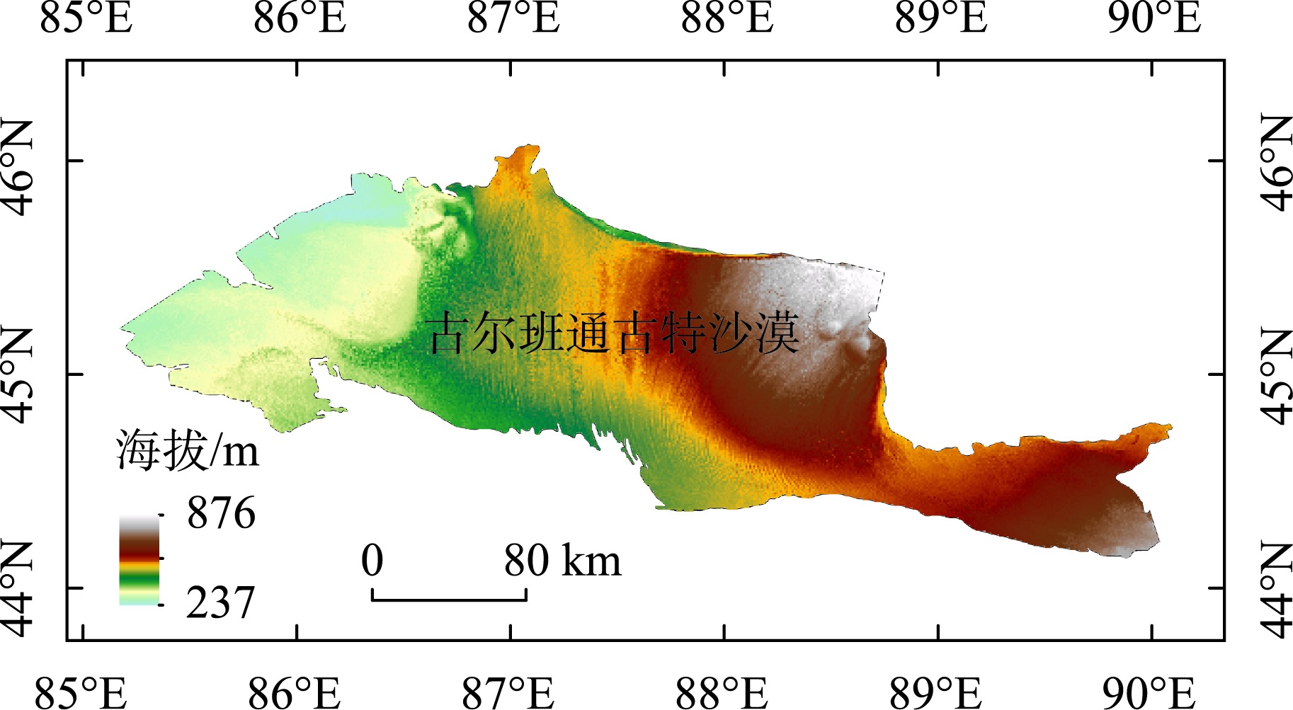
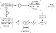
图2
技术路线图"

表1
降尺度因子与土壤含水量相关系数"
| 降尺度因子 | 湿季 | 干季 | |
|---|---|---|---|
| 传统降尺度因子 | NDVI | 0.08 | -0.21** |
| DEM | 0.07 | -0.59** | |
| 新增降尺度因子 | LST | -0.31** | -0.47** |
| RSBI | -0.25** | -0.42** | |
| EMSAVI | -0.34** | -0.37** |
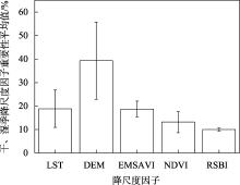
图3
干、湿季降尺度因子重要性得分平均值"


图4
不同时期土壤水分降尺度数据与SMAP土壤水分散点图"

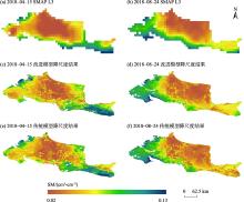
图5
古尔班通古特沙漠干、湿季SMAP L3和相应的土壤表层水分降尺度数据"
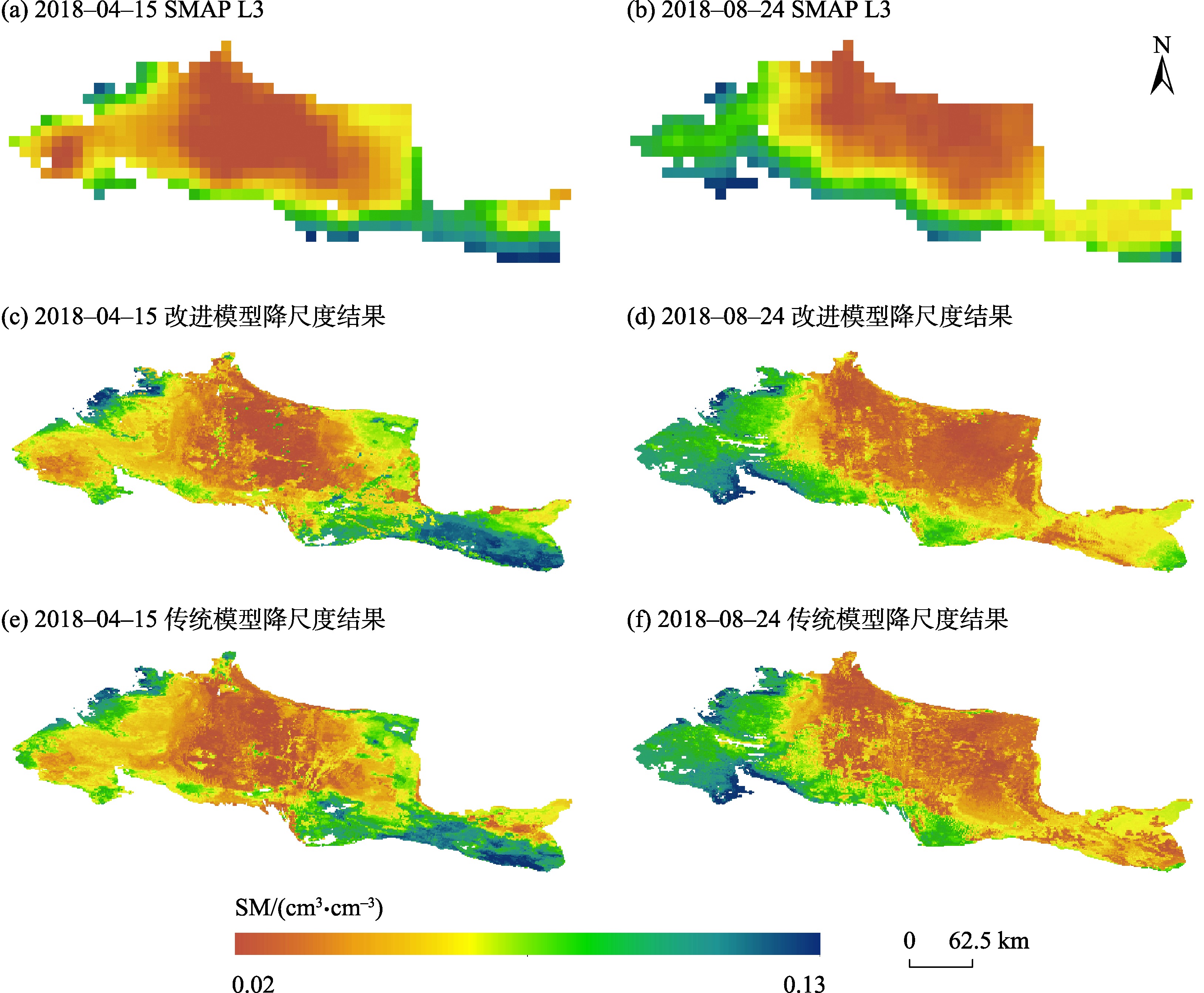
表2
空间一致性评价结果"
| 湿季 | 干季 | |
|---|---|---|
| LBPC-o | 0.065 | 0.067 |
| LBPC-n | 0.057 | 0.060 |
| [1] | 耿德源, 赵天杰, 施建成, 等. 地基雷达的微波面散射模型对比与土壤水分反演[J]. 遥感学报, 2021, 25(4): 929-940. |
| [Geng Deyuan, Zhao Tianjie, Shi Jiancheng, et al. Surface microwave scattering model evaluation and soil moisture retrieval based on ground-based radar data[J]. National Remote Sensing Bulletin, 2021, 25(4): 929-940.] | |
| [2] |
Green J K, Seneviratne S I, Berg A M, et al. Large influence of soil moisture on long-term terrestrial carbon uptake[J]. Nature, 2019, 565(7740): 476-479.
doi: 10.1038/s41586-018-0848-x |
| [3] | 满元伟, 李净, 邢立亭, 等. 基于多源遥感数据的温度-土壤湿度-降水干旱指数(TMPDI)的构建与应用[J]. 干旱区研究, 2021, 38(5): 1442-1451. |
| [Man Yuanwei, Li Jing, Xing Liting, et al. Development and application of the temperature soil moisture precipitation drought index (TMPDI) based on multi-source remote sensing data[J]. Arid Zone Research, 2021, 38(5): 1442-1451.] | |
| [4] | 王静, 方锋, 黄鹏程, 等. AMSR-E土壤水分产品评价及在干旱监测中的应用[J]. 干旱区研究, 2021, 38(3): 650-664. |
| [Wang Jing, Fang Feng, Huang Pengcheng, et al. Evaluation of advanced microwave scanning radiometer for EOS(AMSR-E) soil moisture products over China and its application in drought monitoring[J]. Arid Zone Research, 2021, 38(3): 650-664.] | |
| [5] |
Peng J, Loew A, Merlin O, et al. A review of spatial downscaling of satellite remotely sensed soil moisture[J]. Reviews of Geophysics, 2017, 55(2): 341-366.
doi: 10.1002/rog.v55.2 |
| [6] | 李永康, 王新军, 马燕飞, 等. 基于Catboost的AMSR-2半经验地表温度降尺度[J]. 干旱区研究, 2021, 38(6): 1637-1649. |
| [Li Yongkang, Wang Xinjun, Ma Yanfei, et al. Downscaling land surface temperature through AMSR-2 passive microwave observations by Catboost semiempirical algorithms[J]. Arid Zone Research, 2021, 38(6): 1637-1649.] | |
| [7] | 周壮, 赵少杰, 蒋玲梅. 被动微波遥感土壤水分产品降尺度方法研究综述[J]. 北京师范大学学报(自然科学版), 2016, 52(4): 479-485. |
| [Zhou Zhuang, Zhao Shaojie, Jiang Lingmei. Downscaling methods of passive microwave remore sensing of soil moisture[J]. Journal of Beijing Normal University(Natural Science Edition), 2016, 52(4): 479-485.] | |
| [8] |
王璐, 胡月明, 赵英时, 等. 克里格法的土壤水分遥感尺度转换[J]. 地球信息科学学报, 2012, 14(4): 465-473.
doi: 10.3724/SP.J.1047.2012.00465 |
|
[Wang Lu, Hu Yueming, Zhao Yingshi, et al. Remote sensing scale transformation of soil moisture based on block Kriging[J]. Journal of Geo-information Science, 2012, 14(4): 465-473.]
doi: 10.3724/SP.J.1047.2012.00465 |
|
| [9] | 文凤平, 赵伟, 胡路, 等. 耦合MODIS数据的SMAP被动微波土壤水分空间降尺度研究——以闪电河流域为例[J]. 遥感学报, 2021, 25(4): 962-973. |
| [Wen Fengping, Zhao Wei, Hu Lu, et al. SMAP passive microwave soil moisture spatial downscaling based on optical remote sensing data: A case study in Shandian river basin[J]. National Remote Sensing Bulletin, 2021, 25(4): 962-973.] | |
| [10] | 马小梅, 杜秉晨曦, 程勇翔, 等. 准噶尔盆地植被变化趋势及相关因素分析[J]. 干旱区研究, 2021, 38(5): 1401-1410. |
| [Ma Xiaomei, Du Bingchenxi, Cheng Yongxiang, et al. Analysis of vegetation variation trend and correlative factors in Junggar Basin[J]. Arid Zone Research, 2021, 38(5): 1401-1410.] | |
| [11] | 李彬, 武志芳, 陶冶, 等. 古尔班通古特沙漠不同类型生物结皮对草本植物多样性影响[J]. 干旱区研究, 2021, 38(2): 438-449. |
| [Li Bin, Wu Zhifang, Tao Ye, et al. Effects of biological soil crust type on herbaceous diversity in the Gurbantunggut Desert[J]. Arid Zone Research, 2021, 38(2): 438-449.] | |
| [12] | 邓小进, 井长青, 郭文章, 等. 准噶尔盆地地表反照率时空变化特征及其影响因素分析[J]. 干旱区研究, 2021, 38(2): 314-326. |
| [Deng Xiaojin, Jing Changqing, Guo Wenzhang, et al. Spatio-temporal variation characteristics of surface albedo and analysis of influential factors in the Junggar Basin[J]. Arid Zone Research, 2021, 38(2): 314-326.] | |
| [13] | 尹鑫卫, 郑新军, 李彦, 等. 古尔班通古特沙漠南缘固定沙丘坡面土壤水分动态随机模拟[J]. 应用生态学报, 2019, 30(1): 146-156. |
| [Yin Xinwei, Zheng Xinjun, Li Yan, et al. Hill slope-scale stochastic simulation of soil moisture dynamics in fixed dunes at the southern edge of Gurbantunggut Desert, China[J]. Chinese Journal of Applied Ecology, 2019, 30(1): 146-156.] | |
| [14] | 朱海, 胡顺军, 陈永宝. 古尔班通古特沙漠南缘固定沙丘土壤水分时空变化特征[J]. 土壤学报, 2016, 53(1): 117-126. |
| [Zhu Hai, Hu Shunjun, Chen Yongbao. Spatio-temporal variation of soil moisture in fixed dunes at the southern edge of Gurbantunggut Deser[J]. Acta Pedologica Sinica, 2016, 53(1): 117-126.] | |
| [15] | 金可, 卢阳, 周火明, 等. 古尔班通古特沙漠水文研究进展[J]. 水文, 2022, 42(1): 1-10. |
| [Jin Ke, Lu Yang, Zhou Huoming, et al. Research progress on the hydrology in the Gurbantunggut Desert[J]. Journal of China Hydrology, 2022, 42(1): 1-10.] | |
| [16] |
李娜, 王新军, 常梦迪, 等. 基于Landsat影像稀疏植被斑块格局对降水响应[J]. 新疆农业科学, 2019, 56(10): 1895-1903.
doi: 10.6048/j.issn.1001-4330.2019.10.015 |
|
[Li Na, Wang Xinjun, Chang Mengdi, et al. Response of sparse vegetation patch pattern to precipitation based on Landsat image[J]. Xinjiang Agricultural Sciences, 2019, 56(10): 1895-1903.]
doi: 10.6048/j.issn.1001-4330.2019.10.015 |
|
| [17] | 杜佳倩, 刘彤, 王寒月, 等. 新疆荒漠一年生植物区系组成、分布及资源类型[J]. 干旱区研究, 2022, 39(1): 185-209. |
| [Du Jiaqian, Liu Tong, Wang Hanyue, et al. Floristic composition, distribution, and resource types of desert annual plants in Xinjiang[J]. Arid Zone Research, 2022, 39(1): 185-209.] | |
| [18] | 李从娟, 雷加强, 徐新文, 等. 古尔班通古特沙漠土壤水分与化学性质的空间分布[J]. 生态学报, 2014, 34(15): 4380-4389. |
| [Li Congjuan, Lei Jiaqiang, Xu Xinwen, et al. Spatial pattern for soil water and chemical properties in Gurbantunggut Desert[J]. Acta Ecologica Sinica, 2014, 34(15): 4380-4389.] | |
| [19] | 钱亦兵, 吴兆宁. 古尔班通古特沙漠环境研究[M]. 北京: 科学出版社, 2010: 1-25. |
| [Qian Yibing, Wu Zhaoning. Environmental Research in the Gurbantunggut Desert[M]. Beijing: Science Press, 2010: 1-25.] | |
| [20] | 段呈, 吴玲, 王绍明, 等. 近30年古尔班通古特沙漠短命植物的时空格局[J]. 生态学报, 2017, 37(8): 2642-2652. |
| [Duan Cheng, Wu Ling, Wang Shaoming, et al. Analysis of spatio-temporal patterns of ephemeral plants in the Gurbantünggüt Desert over the last 30 years[J]. Acta Ecologica Sinica, 2017, 37(8): 2642-2652.] | |
| [21] | 庄伟伟, 侯宝林. 古尔班通古特沙漠短命植物的氮素吸收策略[J]. 干旱区研究, 2021, 38(5): 1393-1400. |
| [Zhuang Weiwei, Hou Baolin. Nitrogen uptake strategies of short-lived plants in the Gurbantunggut Desert[J]. Arid Zone Research, 2021, 38(5): 1393-1400.] | |
| [22] |
Entekhabi D, Njoku E G, O"Neill P E, et al. The Soil Moisture Active Passive (SMAP) mission overview[J]. Proceedings of the IEEE, 2010, 98(5): 704-716.
doi: 10.1109/JPROC.2010.2043918 |
| [23] | 贾孜拉·拜山, 李维京, 孙丞虎, 等. 1961—2014年我国西南地区干湿季变化特征[J]. 气候变化研究进展, 2017, 13(2): 103-116. |
| [Jiazila Baishan, Li Weijing, Sun Chenghu, et al. Characteristics of wet and dry seasons in Southwest China during 1961-2014[J]. Climate Change Research, 2017, 13(2): 103-116.] | |
| [24] | 杨红艳, 杜健民, 阮培英, 等. 基于无人机遥感与随机森林的荒漠草原植被分类方法[J]. 农业机械学报, 2021, 52(6): 186-194. |
| [Yang Hongyan, Du Jianmin, Ruan Peiying, et al. Vegetation classification of desert steppe based on unmanned aerial vehicle remote sensing and random forest[J]. Transactions of the Chinese Society for Agricultural Machinery, 2021, 52(6): 186-194.] | |
| [25] | Clewley D, Whitcomb J B, Akbar R, et al. A method for upscaling in situ soil moisture measurements to satellite footprint scale using random forests[J]. IEEE Journal of Selected Topics in Applied Earth Observations & Remote Sensing, 2017, 10(6): 2663-2673. |
| [26] | 李平湘, 刘致曲, 杨杰, 等. 利用随机森林回归进行极化SAR土壤水分反演[J]. 武汉大学学报(信息科学版), 2019, 44(3): 405-412. |
| [Li Pingxiang, Liu Zhiqu, Yang Jie, et al. Soil moisture retrieval of winter wheat fields based on random forest regression using quad-polarimetric SAR images[J]. Geomatics and Information Science of Wuhan University, 2019, 44(3): 405-412.] | |
| [27] |
Breiman L. Random forests[J]. Machine Learning, 2001, 45: 5-32.
doi: 10.1023/A:1010933404324 |
| [28] | 华俊玮, 祝善友, 张桂欣. 基于随机森林算法的地表温度降尺度研究[J]. 国土资源遥感, 2018, 30(1): 78-86. |
| [Hua Junwei, Zhu Shanyou, Zhang Guixin. Downscaling land surface temperature based on random forest algorithm[J]. Remote Sensing for Land and Resources, 2018, 30(1): 78-86.] | |
| [29] | 冯瑞, 杨丽萍, 侯成磊, 等. 基于随机森林的陕西省西安市近地表气温估算[J]. 地球科学与环境学报, 2022, 44(1): 102-113. |
| [Feng Rui, Yang Liping, Hou Chenglei, et al. Estimation of near-surface air temperature in Xi’an City of Shaanxi Province, China based on random forest[J]. Journal of Earth Sciences and Environment, 2022, 44(1): 102-113.] | |
| [30] |
Hutengs C, Vohland M. Downscaling land surface temperatures at regional scales with random forest regression[J]. Remote Sensing of Environment, 2016, 178: 127-141.
doi: 10.1016/j.rse.2016.03.006 |
| [31] | 刘欢欢, 陈印, 刘悦, 等. 基于随机森林模型的黄土高原草地净初级生产力时空格局及未来演变趋势模拟[J]. 干旱区研究, 2023, 40(1): 123-131. |
| [Liu Huanhuan, Chen Yin, Liu Yue, et al. Simulation of spatial pattern and future trends of grassland net primary productivity in the Loess Plateau based on random forest model[J]. Arid Zone Research, 2023, 40(1): 123-131.] | |
| [32] | 王奕森, 夏树涛. 集成学习之随机森林算法综述[J]. 信息通信技术, 2018, 12(1): 49-55. |
| [Wang Yisen, Xia Shutao. A survey of random forests algorithms[J]. Information and Communications Technologies, 2018, 12(1): 49-55.] | |
| [33] |
Xu L. Intercomparison of land-surface parameterization schemes: Sensitivity of surface energy and water fluxes to model parameters[J]. Journal of Hydrology, 2003, 279(1-4): 182-209.
doi: 10.1016/S0022-1694(03)00168-9 |
| [34] | Hiroko K, Matthew R, Frank B, et al. Sensitivity of land surface simulations to model physics, land characteristics, and forcings, at four CEOP sites[J]. Journal of the Meteorological Society of Japan, 2007, 85A: 187-204. |
| [35] | 王家强, 梁继业, 李志军, 等. 利用植被指数-地表温度特征空间反演干旱区土壤干湿状况[J]. 土壤通报, 2014, 45(1): 39-46. |
| [Wang Jiaqiang, Liang Jiye, Li Zhijun, et al. Assessment of arid area soil moisture status based on characteristics of surface temperature/vegetation index space[J]. Chinese Journal of Soil Science, 2014, 45(1): 39-46.] | |
| [36] | 蔡亮红, 丁建丽. 基于改进植被指数土壤水分遥感反演[J]. 干旱区地理, 2017, 40(6): 1248-1255. |
| [Cai Lianghong, Ding Jianli. Remote sensing inversion of soil moisture based on modified vegetation index[J]. Arid Land Geography, 2017, 40(6): 1248-1255.] | |
| [37] |
Thenkabail P S, Enclona E A, Ashton M S, et al. Accuracy assessments of hyperspectral waveband performance for vegetation analysis applications[J]. Remote Sensing of Environment, 2004, 91(3-4): 354-376.
doi: 10.1016/j.rse.2004.03.013 |
| [38] |
Brown L, Chen J M, Leblanc S G, et al. A shortwave infrared modification to the simple ratio for LAI retrieval in boreal forests: An image and model analysis[J]. Remote Sensing of Environment, 2000, 71(1): 16-25.
doi: 10.1016/S0034-4257(99)00035-8 |
| [39] |
李宇君, 张磊. 基于沙地指数模型的沙地监测方法[J]. 地球信息科学学报, 2021, 23(4): 680-691.
doi: 10.12082/dqxxkx.2021.200161 |
|
[Li Yujun, Zhang Lei. Sandy land monitoring method based on classification index model[J]. Journal of Geo-information Science, 2021, 23(4): 680-691.]
doi: 10.12082/dqxxkx.2021.200161 |
|
| [40] |
Im J, Park S, Rhee J, et al. Downscaling of AMSR-E soil moisture with MODIS products using machine learning approaches[J]. Environmental Earth Sciences, 2016, 75(15): 1120.
doi: 10.1007/s12665-016-5917-6 |
| [41] | Cui Y, Chen X, Xiong W, et al. A soil moisture spatial and temporal resolution improving algorithm based on multi-source remote sensing data and GRNN model[J]. International Journal of Applied Mechanics, 2020, 12(3): 455. |
| [42] | 姚云军, 秦其明, 赵少华, 等. 基于MODIS短波红外光谱特征的土壤含水量反演[J]. 红外与毫米波学报, 2011, 30(1): 9-14, 79. |
| [Yao Yunjun, Qin Qiming, Zhao Shaohua, et al. Retrieval of soil moisture based on MODIS shortwave infrared spectral feature[J]. Journal of Infrared and Millimeter Waves, 2011, 30(1): 9-14, 79.] | |
| [43] | 高琪, 王玉珍, 冯春晖, 等. 基于改进型光谱指数的荒漠土壤水分遥感反演[J]. 自然资源遥感, 2022, 34(1): 142-150. |
| [Gao Qi, Wang Yuzhen, Feng Chunhui, et al. Remote sensing inversion of desert soil moisture based on improved spectral indices[J]. Remote Sensing for Natural Resources, 2022, 34(1): 142-150.] | |
| [44] |
Zhao W, Sánchez N, Lu H, et al. A spatial downscaling approach for the SMAP passive surface soil moisture product using random forest regression[J]. Journal of Hydrology, 2018, 563: 1009-1024.
doi: 10.1016/j.jhydrol.2018.06.081 |
| [45] |
Zhu X, Zhan W, Zhou J, et al. A novel framework to assess all-round performances of spatiotemporal fusion models[J]. Remote Sensing of Environment, 2022, 274: 113002.
doi: 10.1016/j.rse.2022.113002 |
| [1] | 李小雨, 贾科利, 魏慧敏, 陈睿华, 王怡婧. 基于随机森林算法的土壤含盐量预测[J]. 干旱区研究, 2023, 40(8): 1258-1267. |
| [2] | 李健男, 史海滨, 苗庆丰, 珊丹, 荣浩, 温雅琴. 环境因子对不同种类人工乔木林分蒸腾耗水的影响[J]. 干旱区研究, 2023, 40(8): 1312-1321. |
| [3] | 吉吉佳门, 程一本, 谌玲珑, 万鹏翔, 张祎晖, 杨文斌, 白旭赢, 王涛. 科尔沁沙地樟子松人工林土壤水分动态及其对降雨的响应[J]. 干旱区研究, 2023, 40(5): 756-766. |
| [4] | 许毓哲, 林涛, 李君. 替代稳态下阜康北部荒漠生态弹性的时空格局[J]. 干旱区研究, 2023, 40(5): 808-817. |
| [5] | 杨霜奇, 宋乃平, 王兴, 陈晓莹, 常道琴. 荒漠草原灰钙土与风沙土水分时空特征[J]. 干旱区研究, 2023, 40(10): 1625-1636. |
| [6] | 刘欢欢, 陈印, 刘悦, 刚成诚. 基于随机森林模型的黄土高原草地净初级生产力时空格局及未来演变趋势模拟[J]. 干旱区研究, 2023, 40(1): 123-131. |
| [7] | 肖森天, 依力亚斯江·努尔麦麦提, 努尔比耶·穆合塔尔, 赵静, 阿迪莱·阿卜来提. 基于光学和雷达多源遥感的于田绿洲土壤盐渍化时空分析[J]. 干旱区研究, 2023, 40(1): 59-68. |
| [8] | 李炎坤,高黎明,张乐乐,吴雪晴,刘轩辰,祁闻. 青海湖流域及周边区域TRMM 3B43降水数据降尺度方法对比分析[J]. 干旱区研究, 2022, 39(6): 1706-1716. |
| [9] | 祝存兄,史飞飞,乔斌,张娟,陈国茜. 基于高分1号卫星数据的青海湖扩张及湖滨沙地变化特征分析[J]. 干旱区研究, 2022, 39(4): 1076-1089. |
| [10] | 强玉泉,徐先英,张锦春,刘虎俊,郭树江,段晓峰. 民勤青土湖梭梭茎干液流特征及其对环境因子的响应[J]. 干旱区研究, 2022, 39(4): 1143-1154. |
| [11] | 张鹏飞,贾小旭,赵春雷,邵明安. 初始容重对土壤水分特征曲线的影响[J]. 干旱区研究, 2022, 39(4): 1174-1180. |
| [12] | 杨紫唯,车子涵,刘芙梅,陈克龙. 降水梯度对青海湖河源湿地温室气体排放日变化的影响[J]. 干旱区研究, 2022, 39(3): 754-766. |
| [13] | 周彦莉,吴海梅,周彦栋,尚旭民,逄蕾. 短期秸秆不同还田方式对土壤结构和水分影响[J]. 干旱区研究, 2022, 39(2): 502-509. |
| [14] | 刘畅,张红,张霄羽,杨国婷,刘勇. 半干旱地区矿区土地利用时空演变与预测[J]. 干旱区研究, 2022, 39(1): 292-300. |
| [15] | 李永康,王新军,马燕飞,胡贵锋,桂海月,张冠宏. 基于Catboost的AMSR-2半经验地表温度降尺度[J]. 干旱区研究, 2021, 38(6): 1637-1649. |
|
||