| [1] |
樊自立, 艾里西尔·库尔班, 徐海量, 等. 塔里木河的变迁与罗布泊的演化[M]. 第四纪研究, 2009, 29(2): 232-240.
|
|
[Fan Zili, Alishir Kurban, Xu Hailiang, et al. Changes of Tarim River and evolution of Lop NUR[J]. Quaternaru Sciences, 2009, 29(2): 232-240. ]
|
| [2] |
郭宏伟, 徐海量, 凌红波, 等. 塔里木河流域人工与天然绿洲转化过程与适宜比例初探[J]. 土壤通报, 2017, 48(3): 532-539.
|
|
[Guo Hongwei, Xu Hailiang, Ling Hongbo, et al. A preliminary study on the transformation process and suitable ratio between artificial and natural oasis in the Tarim River Basin[J]. Soil Bulletin, 2017, 48(3): 532-539. ]
|
| [3] |
陈亚宁, 吾买尔江·吾布力, 艾克热木·阿布拉, 等. 塔里木河下游近20 a输水的生态效益监测分析[J]. 干旱区地理, 2021, 44(3): 605-611.
|
|
[Chen Yaning, Wumaierjiang Wuburi, Ekhermu Abula, et al. Monitoring and analysis of ecological benefits of water conveyance in the lower reaches of Tarim River in recent 20 years[J]. Arid Land Geography, 2021, 44(3): 605-611. ]
|
| [4] |
李丽君, 张小清, 陈长清, 等. 近20 a塔里木河下游输水对生态环境的影响[J]. 干旱区地理, 2018, 41(2): 238-247.
|
|
[Li Lijun, Zhang Xiaoqing, Chen Changqing, et al. Ecological effects of water conveyance on the lower reachesof Tarim River in recent twenty years[J]. Arid Land Geography, 2018, 41(2): 238-247. ]
|
| [5] |
李玉朋, 陈亚宁, 叶朝霞, 等. 塔里木河下游输水20 a的生态响应[J]. 干旱区地理, 2021, 44(3): 700-707.
|
|
[Li Yupeng, Chen Yaning, Ye Zhaoxia, et al. Ecological responses of ecological water conveyance in the lower reaches of Tarim River for 20 years[J]. Arid Land Geography, 2021, 44(3): 700-707. ]
|
| [6] |
Li W, Huang F, Shi F, et al. Human and climatic drivers of land and water use from 1997 to 2019 in Tarim River basin, China[J]. International Soil and Water Conservation Research, 2021, 9(4): 532-543.
doi: 10.1016/j.iswcr.2021.05.001
|
| [7] |
Huang Y, Ma Y, Liu T, et al. Climate change impacts on extreme flows under IPCC RCP Scenarios in the mountainous Kaidu watershed, Tarim River Basin[J]. Sustainability, 2020, 12(5): 2090.
doi: 10.3390/su12052090
|
| [8] |
邓铭江, 杨鹏年, 周海鹰, 等. 塔里木河下游水量转化特征及其生态输水策略[J]. 干旱区研究, 2017, 34(4): 717-726.
|
|
[Deng Mingjiang, Yang Pengnian, Zhou Haiying, et al. Water conversion characteristics and ecological water transportation strategies in the lower reaches of the Tarim River[J]. Arid Zone Research, 2017, 34(4): 717-726. ]
|
| [9] |
王珊珊, 王金林, 周可法, 等. 塔里木河下游土地利用/覆被变化对生态输水的响应[J]. 水资源保护, 2021, 37(2): 69-74.
|
|
[Wang Shanshan, Wang Jinlin, Zhou Kefa, et al. The response of land use/cover change to ecological water transport in the lower reaches of the Tarim River[J]. Water Resources Conservation, 2021, 37(2): 69-74. ]
|
| [10] |
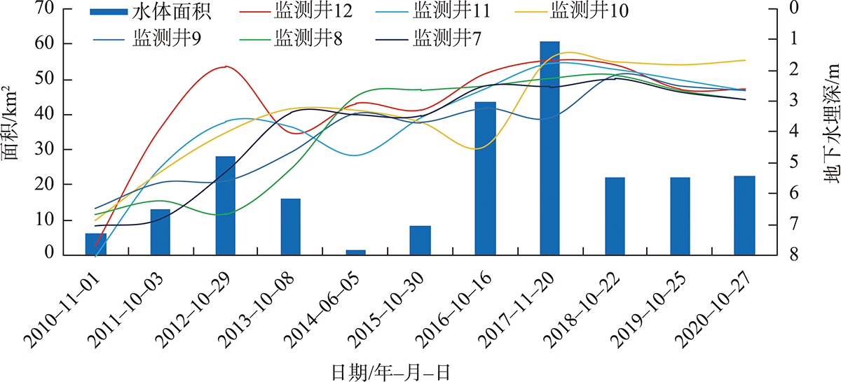
邹珊, 吉力力·阿不都外力, 黄文静, 等. 塔里木河下游生态输水对地表水体面积变化的影响[J]. 干旱区地理, 2021, 44(3): 681-690.
|
|
[Zou Shan, Jilili Abuduwaili, Huang Wenjing, et al. Effects of ecological water transport on surface water area change in the lower reaches of Tarim River[J]. Arid Land Geography, 2021, 44(3): 681-690. ]
|
| [11] |
雍正, 赵成义, 施枫芝, 等. 近20 a塔里木河干流区地下水埋深变化特征及其生态效应研究[J]. 水土保持学报, 2020, 34(3): 182-189.
|
|
[Yong Zheng, Zhao Chengyi, Shi Fengzhi, et al. Study on the characteristics of groundwater depth change and its ecological effects in the mainstream of the Tarim River in the past 20 years[J]. Journal of Soil and Water Conservation, 2020, 34(3): 182-189. ]
|
| [12] |
沈海岑, 薛联青. 基于土地利用变化的塔里木河下游区近20 a景观生态风险研究[J]. 中国农村水利水电, 2020(11): 77-82.
|
|
[Shen Haicen, Xue Lianqing. Study on landscape ecological risk in the lower reaches of Tarim River in recent 20 years based on land use change[J]. China Rural Water and Hydropower, 2020(11): 77-82. ]
|
| [13] |
邓铭江, 周海鹰, 徐海量, 等. 塔里木河下游生态输水与生态调度研究[J]. 中国科学(技术科学), 2016, 46(8): 864-876.
|
|
[Deng Mingjiang, Zhou Haiying, Xu Hailiang, et al. Ecological water transport and ecological regulation in the lower reaches of the Tarim River[J]. Science Sinica (Technologica), 2016, 46(8): 864-876. ]
|
| [14] |
苏龙飞, 李振轩, 高飞, 等. 遥感影像水体提取研究综述[J]. 国土资源遥感, 2021, 33(1): 9-19.
|
|
[Su Longfei, Li Zhenxuan, Gao Fei, et al. A review of remote sensing image water extraction[J]. Remote Sensing for Land and Resources 2021, 33(1): 9-19. ]
|
| [15] |
Xu B D, Li J, Park Taejin, et al. Improving leaf area index retrieval over heterogeneous surface mixed with water[J]. Remote Sensing of Environment, 2020, 240: 111700.
doi: 10.1016/j.rse.2020.111700
|
| [16] |
叶茂, 徐海量, 任铭. 塔里木河下游生态输水的合理时间初探[J]. 干旱区研究, 2012, 29(5): 907-912.
|
|
[Ye Mao, Xu Hailiang, Ren Ming. A preliminary study on the reasonable time of ecological water transportation in the lower reaches of the Tarim River[J]. Arid Zone Research, 2012, 29(5): 907-912. ]
|
| [17] |
丛振涛, 周海鹰, 雷志栋, 等. 塔里木河下游输水过程的分析与模拟[J]. 水科学进展, 2003, 14(3): 276-279.
|
|
[Cong Zhentao, Zhou Haiying, Lei Zhidong, et al. Analysis and simulation of water conveyance process in the lower reaches of Tarim River[J]. Advances in Water Science, 2003, 14(3): 276-279. ]
|
| [18] |
王文焰, 张建丰, 汪志荣, 等. 波涌灌溉条件下土壤致密层的形成及其对入渗特性的影响[J]. 水利学报, 1996, 27(7): 75-81.
|
|
[Wang Wenyan, Zhang Jianfeng, Wang Zhirong, et al. The formation of soil dense layer under surge irrigation and its effect on infiltration characteristics[J]. Journal of Hydraulic Engineering, 1996, 27(7): 75-81. ]
|
| [19] |
陈永金, 李卫红, 陈亚宁, 等. 塔里木河流域综合治理的生态效应[J]. 中国环境科学, 2007, 27(1): 24-28.
|
|
[Chen Yongjin, Li Weihong, Chen Yaning, et al. Ecological effects of comprehensive management in Tarim River Basin[J]. China Environmental Science, 2007, 27(1): 24-28. ]
|
| [20] |
杨鹏年, 张胜江, 董新光. 塔里木河干流下游生态输水后水量转化特征[J]. 干旱区研究, 2007, 24(2): 174-178.
|
|
[Yang Pengnian, Zhang Shengjiang, Dong Xinguang. Characteristics of water transfer after ecological water transport in the lower reaches of Tarim River[J]. Arid Zone Research, 2007, 24(2): 174-178. ]
|
| [21] |
傅渝亮, 费良军, 聂卫波, 等. 波涌灌间歇入渗饱和-非饱和土壤水分运动数值模拟及试验[J]. 农业工程学报, 2015, 31(2): 66-71.
|
|
[Fu Yuliang, Fei Liangjun, Nie Weibo, et al. Numerical simulation and experiment on saturated-unsaturated soil water movement in intermittent infiltration of surge irrigation[J]. Transactions of the Chinese Society of Agricultural Engineering, 2015, 31(2): 66-71. ]
|
| [22] |
陈曦, 黄粤, 钱静, 等. 干旱区内陆河漫溢型生态用水调控的模拟分析——以塔里木河干流灿木里克生态区为例[J]. 中国科学: 地球科学, 2006, 36(增刊2): 1-8.
|
|
[Chen Xi, Huang Yue, Qian Jing, et al. Simulation and analysis of the regulation of ecological water use in the inland river overflow in arid area: A case study of the Tarim River Basin[J]. Scientia Sinica(Terrae), 2006, 36(Suppl.2): 1-8. ]
|
 ),杨鹏年1,2(