Arid Zone Research ›› 2023, Vol. 40 ›› Issue (9): 1472-1483.doi: 10.13866/j.azr.2023.09.11
• Plant Ecology • Previous Articles Next Articles
SUN Danyang1,2( ),WEI Jianxin1,2,3(),YANG Liao4,WANG Jie5,TANG Yuqi4,Babierjiang DILIXIATI2,3
Received:2023-04-01
Revised:2023-05-16
Online:2023-09-15
Published:2023-09-28
Contact:
Jianxin WEI
E-mail:1063209224@qq.com;wjxlr@126.com
SUN Danyang,WEI Jianxin,YANG Liao,WANG Jie,TANG Yuqi,Babierjiang DILIXIATI. Study on using deep learning method to retrieve the biomass of natural Picea forest from GEDI data[J].Arid Zone Research, 2023, 40(9): 1472-1483.
Add to citation manager EndNote|Reference Manager|ProCite|BibTeX|RefWorks
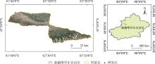
Fig. 1
Sketch map of the study area"

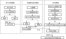
Fig. 2
Technology roadmap"

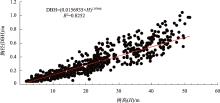
Fig. 3
Regression fitting of H and DBH in the sample plot"


Fig. 4
Flow chart of helicopter airborne point cloud data processing"

Fig. 5
Segmentation process based on CHM"

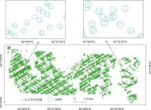
Fig. 6
Point cloud data individual tree recognition and GEDI data distribution in the study area"

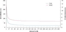
Fig. 7
Curve chart of MAE and Loss changes in deep learning model"

Tab. 1
Model structure syst"
| 网络层 | 输出大小 | 参数个数 |
|---|---|---|
| 输入 | [(None,81)] | 0 |
| 多类别编码层 | (None,81) | 0 |
| 归一化层 | (None,81) | 163 |
| 全连接层 | (None,64) | 5248 |
| 激活函数1 | (None,64) | 0 |
| 全连接层 | (None,1024) | 66560 |
| 激活函数2 | (None,1024) | 0 |
| 回归层 | (None,1) | 1025 |
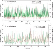
Fig. 8
DL prediction result graph"

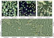
Fig. 9
Partial display of individual tree segmentation effect in the study area"

Tab. 2
Evaluation index for individual tree segmentation of sample land"
| 评价指标 | 召回率(R)/% | 准确度(P)/% | F值/% |
|---|---|---|---|
| 样地1 | 67.40 | 93.93 | 78.48 |
| 样地2 | 78.57 | 96.70 | 82.24 |
| 样地3 | 89.40 | 84.29 | 86.77 |
| 平均值 | 78.46 | 88.16 | 82.50 |
Tab. 3
Prediction indicators for AGB under deep learnin"
| 模型评价指标 | 数据集 | R2 | RMSE /(mg·hm-2) | MAE /(mg·hm-2) |
|---|---|---|---|---|
| 深度学习(DL) | 训练集 | 0.69 | 4.68 | 3.73 |
| 验证集 | 0.63 | 5.31 | 4.22 | |
| 总体数据 | 0.67 | 4.88 | 3.89 |
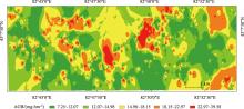
Fig. 10
Schematic diagram of AGB in the study area"

| [1] | Olson, Jerry S, Watts J A, et al. Carbon in Live Vegetation of Major World Ecosystems[M]. Teen: ORNL-5862, 1983: 15-25. |
| [2] | Hua Dengxin, Song Xiaoquan. Advances in lidar remote sensing techniques[J]. Infrared and Laser Engineering, 2008, 37(1): 21-27. |
| [3] | 庞勇, 李增元, 陈尔学, 等. 激光雷达技术及其在林业上的应用[J]. 林业科学, 2005, 41(3): 129-136. |
| [Pang Yong, Li Zengyuan, Chen Erxue, et al. Lidar remote sensing technology and its application in forestry[J]. Scientia Silvae Sinicae, 2005, 41(3): 129-136.] | |
| [4] | 李增元, 刘清旺, 庞勇. 激光雷达森林参数反演研究进展[J]. 遥感学报, 2016, 20(5): 1138-1150. |
| [Li Zengyuan, Liu Qingwang, Pang Yong. Review on forest parameters inversion using LiDAR[J]. Journal of Remote Sensing, 2016, 20(5): 1138-1150.] | |
| [5] | 胡国军, 方勇, 张丽. 星载激光雷达的发展与测绘应用前景分析[J]. 测绘技术装备, 2015, 17(2): 34-37. |
| [Hu Guojun, Fang Yong, Zhang Li. Development of spaceborne lidar and prospect analysis of surveying and mapping applications[J]. Geomatics Technology and Equipment, 2015, 17(2): 34-37.] | |
| [6] | 谢栋平, 李国元, 赵严铭, 等. 美国GEDI天基激光测高系统及其应用[J]. 国际太空, 2018, 40(12): 39-44. |
| [Xie Dongping, Li Guoyuan, Zhao Yanming, et al. GEDI space-based laser altimeter system and its application in the United State[J]. Space International, 2018, 40(12): 39-44.] | |
| [7] |
Adam M, Urbazaev M, Dubois C, et al. Accuracy assessment of GEDI terrain elevation and canopy height estimates in European temperate forests: Influence of environmental and acquisition parameters[J]. Remote Sensing, 2020, 12(23): 3948.
doi: 10.3390/rs12233948 |
| [8] | 韩明辉. 基于星载激光雷达GEDI数据反演森林结构参数的研究[D]. 哈尔滨: 东北林业大学, 2022. |
| [Han Minghui. Study on Forest Structure Parameters Inversion based on GEDI Data[D]. Harbin: Northeast Forestry University, 2022.] | |
| [9] |
Alireza H, Cheikh M, Annika K, et al. Deep learning for forest inventory and planning: A critical review on the remote sensing approaches so far and prospects for further applications[J]. Forestry: An International Journal of Forest Research, 2022, 95(4): 451-465.
doi: 10.1093/forestry/cpac002 |
| [10] | Cao Lin, She Guanghui, Dai Jinsong, et al. Status and prospects of the lidar-based forest biomass estimation[J]. Journal of Nanjing Forestry University, 2013, 56(3): 163-169. |
| [11] |
Torre-Tojal L, Bastarrika A, Boyano A, et al. Above-ground biomass estimation from lidar data using random forest algorithms[J]. Journal of Computational Science, 2022, 58: 101517.
doi: 10.1016/j.jocs.2021.101517 |
| [12] |
Quirós E, Polo M E, Fragoso-Campón L. GEDI elevation accuracy assessment: A case study of southwest Spain[J]. IEEE Journal of Selected Topics in Applied Earth Observations and Remote Sensing, 2021, 14: 5285-5299.
doi: 10.1109/JSTARS.2021.3080711 |
| [13] |
Fayad I, Baghdadi N N, Alvares C A, et al. Assessment of Gedi’s lidar data for the estimation of canopy heights and wood volume of eucalyptus plantations in Brazil[J]. IEEE Journal of Selected Topics in Applied Earth Observations and Remote Sensing, 2021, 14: 7095-7110.
doi: 10.1109/JSTARS.2021.3092836 |
| [14] |
Fayad I, Baghdadi N N, Alvares C A, et al. Terrain slope effect on forest height and wood volume estimation from GEDI data[J]. Remote Sensing, 2021, 13(11): 2136.
doi: 10.3390/rs13112136 |
| [15] |
Healey S P, Yang Z, Gorelick N, et al. Highly local model calibration with a new GEDI lidar asset on Google Earth Engine reduces Landsat forest height signal saturation[J]. Remote Sensing, 2020, 12(17): 2840.
doi: 10.3390/rs12172840 |
| [16] |
Fayad I, Baghdadi N, Bailly J S, et al. Analysis of GEDI elevation data accuracy for inland waterbodies altimetry[J]. Remote Sensing, 2020, 12(17): 2714.
doi: 10.3390/rs12172714 |
| [17] |
Potapov P, Li X, Hernandez-Serna A, et al. Mapping global forest canopy height through integration of GEDI and Landsat data[J]. Remote Sensing of Environment, 2020, 253: 112165.
doi: 10.1016/j.rse.2020.112165 |
| [18] | 林晓娟. 基于ICESat-2和GEDI森林冠层高度和森林地上生物量遥感诊断[D]. 北京: 中国科学院大学, 2021. |
| [Lin Xiaojuan. Remote Sensing Diagnosis of Forest Canopy Height and Forest Aboveground Biomass based on ICESat-2 and GEDI[D]. Beijing: University of Chinese Academy of Sciences, 2021.] | |
| [19] | 朱笑笑. 基于ICESat-2和GEDI数据的中国30米分辨率森林高度反演研究[D]. 北京: 中国科学院大学, 2021. |
| [Zhu Xiaoxiao. Forest Height Retrieval of China with a Resolution of 30 m Using ICESat-2 and GEDI Data[D]. Beijing: University of Chinese Academy of Sciences, 2021.] | |
| [20] |
Ngo Y N, Ho Tong Minh D, Baghdadi N, et al. Tropical forest top height by GEDI: From sparse coverage to continuous data[J]. Remote Sensing, 2023, 15(4): 975.
doi: 10.3390/rs15040975 |
| [21] |
Schneider F D, Ferraz A, Hancock S, et al. Towards mapping the diversity of canopy structure from space with GEDI[J]. Environmental Research Letters, 2020, 15(11): 115006.
doi: 10.1088/1748-9326/ab9e99 |
| [22] |
Roy D P, Kashongwe H B, Armston J. The Impact of geolocation uncertainty on GEDI tropical forest canopy height estimation and change monitoring[J]. Science of Remote Sensing, 2021, 4: 100024.
doi: 10.1016/j.srs.2021.100024 |
| [23] |
Bauer L, Knapp N, Fischer R. Mapping Amazon forest productivity by fusing GEDI lidar waveforms with an individual-based forest model[J]. Remote Sensing, 2021, 13(22): 4540.
doi: 10.3390/rs13224540 |
| [24] | 李明辉, 何风华, 刘云, 等. 天山云杉种群空间格局与动态[J]. 生态学报, 2005, 25(5): 1000-1006. |
| [Li Minghui, He Fenghua, Liu Yun, et al. Spatial distribution pattern of tree individuals in the Schrenk spruce forest, Northwest China[J]. Acta Ecologica Sinica, 2005, 25(5): 1000-1006.] | |
| [25] | 王雅佩, 王振锡, 刘梦婷, 等. 基于无人机影像天山云杉林主伐迹地提取研究[J]. 新疆农业科学, 2019, 56(7): 1312-1324. |
| [Wang Yapei, Wang Zhenxi, Liu Mengting, et al. Research on extraction of final felling area of Picea schrenkiana var tianshanica based on UAV image[J]. Xinjiang Agricultural Sciences, 2019, 56(7): 1312-1324.] | |
| [26] | Soille P. Morphological Image Analysis-Principles and Applications[M]. Berlin: Springer-Verlag, 2003. |
| [27] | Dubayah R, Hofton M, Blair M J B, et al. GEDI L2A elevation and height metrics data global footprint level V001[DB/OL]. NASA EOSDIS Land Processes Distributed Active Archive Center, 2023-08-15, https://doi.org/10.5067/GEDI/GEDI02_A.001. |
| [28] |
Dubayah R, Blair J B, Goetz S, et al. The global ecosystem dynamics investigation: High-resolution laser ranging of the earth’s forests and topography[J]. Science of Remote Sensing, 2020, 1: 100002.
doi: 10.1016/j.srs.2020.100002 |
| [29] | 张绘芳, 高亚琪, 朱雅丽, 等. 新疆雪岭杉生物量模型对比研究[J]. 西北林学院学报, 2015, 30(6): 52-58. |
| [Zhang Huifang, Gao Yaqi, Zhu Yali, et al. A comparative study on biomass models for Picea schrenkiana in Xinjiang[J]. Journal of Northwest Forestry University, 2015, 30(6): 52-58.] | |
| [30] |
Li Wenkai, Guo Qinghua, Jakubowski M K, et al. A new method for segmenting individual trees from the lidar point cloud[J]. Photogrammetric Engineering and Remote Sensing, 2012, 78: 75-84.
doi: 10.14358/PERS.78.1.75 |
| [31] | Hofton M, Blair J B, Story S, et al. Algorithm Theoretical Basis Document(ATBD) for GEDI transmit and receive waveform processing for L1 and L2 products[EB/OL]. Goddard Space Flight Centre, 2019. https://lpdaac.usgs.gov/documents/581/GEDI_WF_ATBD_v1.0.pdf. |
| [32] |
Rishmawi K, Huang C, Schleeweis K, et al. Integration of VIIRS observations with GEDI-lidar measurements to monitor forest structure dynamics from 2013 to 2020 across the conterminous United States[J]. Remote Sensing, 2022, 14(10): 2320.
doi: 10.3390/rs14102320 |
| [33] | 胡涛. 基于多源数据的孟家岗林场针叶林蓄积量估测研究[D]. 哈尔滨: 东北林业大学, 2022. |
| [Hu Tao. Estimation of Coniferous Forest Volume in Mengjiagang Forest Farm Based on Multi-source data[D]. Harbin: Northeast Forestry University, 2022.] | |
| [34] |
Knapp N, Huth A, Fischer R. Tree crowns cause border effects in area-based biomass estimations from remote sensing[J]. Remote Sensing, 2021, 13(8): 1592.
doi: 10.3390/rs13081592 |
| [1] | QIU Chunxia, LIU Xiaohong, LI Dou, ZHANG Jiamiao, LI Pengfei. Application of airborne LiDAR with fuzzy inference system in soil erosion monitoring on the Loess Plateau [J]. Arid Zone Research, 2024, 41(8): 1331-1342. |
| [2] | LI Ruonan, LI Junli, LI Shuangshuang, LIU Shuaiqi, DU Weibin. Monitoring the glacier changes in Yilian Habirga Mountain using Sentinel-2 data [J]. Arid Zone Research, 2024, 41(6): 940-950. |
| [3] | LIANG Boming, LIU Xin, HAO Yuanyuan, CHU Bin, TANG Zhuangsheng. Extraction of desert vegetation information based on five vegetation indices [J]. Arid Zone Research, 2023, 40(4): 647-654. |
| [4] | WANG Jiaojiao, YIN Xiaojun, LIU Shannan, WANG Dimeng. Study on the change and prediction of spatiotemporal pattern of land use in Manasi region based on deep learning [J]. Arid Zone Research, 2023, 40(1): 69-77. |
| [5] | LI Cheng-Xiu, LI Xiao-Yan, YANG Tai-Bao, LI Yue-Tan-. Structure and Species Diversity of Meadow Community along the Shaliu River in the Qinghai Lake Basin [J]. , 2013, 30(6): 1028-1035. |
|
||