Arid Zone Research ›› 2024, Vol. 41 ›› Issue (6): 940-950.doi: 10.13866/j.azr.2024.06.04
• Land and Water Resources • Previous Articles Next Articles
LI Ruonan1,2,3( ), LI Junli1,3(), LI Shuangshuang1,4, LIU Shuaiqi1,2,3, DU Weibin4
Received:2023-10-23
Revised:2024-01-30
Online:2024-06-15
Published:2024-07-03
LI Ruonan, LI Junli, LI Shuangshuang, LIU Shuaiqi, DU Weibin. Monitoring the glacier changes in Yilian Habirga Mountain using Sentinel-2 data[J].Arid Zone Research, 2024, 41(6): 940-950.
Add to citation manager EndNote|Reference Manager|ProCite|BibTeX|RefWorks
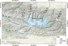
Fig. 1
Map of study area"

Tab. 1
The selected dates of remote sensing data for glacier mapping"
| 遥感数据类型 | 获取时间/年-月-日 | |||||||
|---|---|---|---|---|---|---|---|---|
| Landsat-8 | 2016-09-19 | 2017-07-29 | 2018-08-17 | 2019-10-07 | 2020-08-22 | 2021-07-24 | 2022-07-11 | |
| Sentienl-2 | 2016-09-19 | 2017-07-08 | 2018-08-20 | 2019-08-30 | 2020-07-17 | 2021-07-25 | 2022-07-22 | |
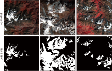
Fig. 2
Sample set and corresponding labels map"

Tab. 2
Comparisons of mapping accuracies with different types of satellite data"
| 数据类别 | 评价指标 | ||||
|---|---|---|---|---|---|
| PA | UA | OA | F1 | IoU | |
| Sentinel-2 | 0.831 | 0.851 | 0.950 | 0.835 | 0.768 |
| Landsat-8 | 0.748 | 0.832 | 0.916 | 0.780 | 0.679 |
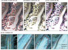
Fig. 3
Comparisons of glacier extents with different satellite data"

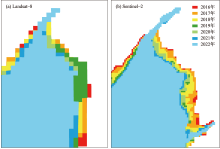
Fig. 4
Comparisons of glacier boundaries derived by Sentinel-2 and Landsat-8"

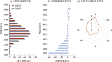
Fig. 5
Glacier area change rates during 2016-2022 in different altitudes and slopes"

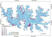
Fig. 6
Schematic diagram of the spatial distribution and retreat rate of typical glaciers"

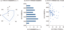
Fig. 7
Average annual shrinking rate of glaciers in different slopes and altitudes"
| [1] | Kraaijenbrink P, Bierkens M, Lutz A, et al. Impact of a global temperature rise of 1.5 degrees Celsius on Asia’s glaciers[J]. Nature, 2017, 549(7671): 257-260. |
| [2] | 李开明, 陈世峰, 康玲芬, 等. 中国大陆型冰川和海洋型冰川变化比较分析——以天山乌鲁木齐河源1号冰川和玉龙雪山白水河1号冰川为例[J]. 干旱区研究, 2018, 35(1): 12-19. |
| [Li Kaiming, Chen Shifeng, Kang Lingfen, et al. Comparative research on Chinese continental glacier and temperate glacier changes: Taking Urumqi glacier No.1 and Baishui glacier No.1 as example[J]. Arid Zone Research, 2018, 35(1): 12-19. ] | |
| [3] | 王利辉, 秦翔, 陈记祖, 等. 1961—2013年祁连山区冰川年物质平衡重建[J]. 干旱区研究, 2021, 38(6): 1524-1533. |
| [Wang Lihui, Qin Xiang, Chen Jizu, et al. Reconstruction of the glacier mass balance in the Qilian Mountains from 1961 to 2013[J]. Arid Zone Research, 2021, 38(6): 1524-1533. ] | |
| [4] | 都伟冰, 张世琼, 李均力, 等. 中亚高山冰川表面高程变化时序重建[J]. 干旱区研究, 2022, 39(3): 676-683. |
| [Du Weibing, Zhang Shiqiong, Li Junli, et al. Temporal reconstruction of alpine glacier surface elevation variation in Central Asia[J]. Arid Zone Research, 2022, 39(3): 676-683. ] | |
| [5] | Poddar J, Pandey A C. Estimating the impact of changes in mass balance on variations in glacier area and snout fluctuations in Western Himalayas, J&K India[C]// 2014 IEEE Geoscience and Remote Sensing Symposium. IEEE, 2014: 4034-4037. |
| [6] | 李忠勤, 李开明, 王林. 新疆冰川近期变化及其对水资源的影响研究[J]. 第四纪研究, 2010, 30(1): 96-106. |
| [Li Zhongqin, Li Kaiming, Wang Lin. Study on the recent changes of glaciers in Xinjiang and their impact on water resources[J]. Quaternary Sciences, 2010, 30(1): 96-106. ] | |
| [7] |
张慧, 李忠勤, 牟建新, 等. 近50年新疆天山奎屯河流域冰川变化及其对水资源的影响[J]. 地理科学, 2017, 37(11): 1771-1777.
doi: 10.13249/j.cnki.sgs.2017.11.020 |
|
[Zhang Hui, Li Zhongqin, Mou Jianxin, et al. Changes of glaciers in the Kuitun River Basin of the Tianshan Mountains in Xinjiang in the last 50 years and their impact on water resources[J]. Scientia Geographica Sinica, 2017, 37(11): 1771-1777. ]
doi: 10.13249/j.cnki.sgs.2017.11.020 |
|
| [8] |
赵贵宁, 张正勇, 刘琳, 等. 基于多源遥感数据的玛纳斯河流域冰川物质平衡变化[J]. 地理学报, 2020, 75(1): 98-112.
doi: 10.11821/dlxb202001008 |
|
[Zhao Guining, Zhang Zhengyong, Liu Lin, et al. Changes in glacier material balance in the Manas River basin based on multi-source remote sensing data[J]. Acta Geographica Sinica, 2020, 75(1): 98-112. ]
doi: 10.11821/dlxb202001008 |
|
| [9] | 李志杰, 王宁练, 常佳雯. 巴托拉等冰川的新近变化及对中巴公路的影响[J]. 干旱区研究, 2022, 39(6): 1986-1995. |
| [Li Zhijie, Wang Ninglian, Chang Jiawen. Recent variations of the Batura, Pasu, and Ghulkin glaciers and their potential impact on the Karakoram highway[J]. Arid Zone Research, 2022, 39(6): 1986-1995. ] | |
| [10] | Kachouie N N, Gerke T, Huybers P, et al. Nonparametric regression for estimation of spatiotemporal mountain glacier retreat from satellite images[J]. IEEE Transactions on Geoscience and Remote Sensing, 2014, 53(3): 1135-1149. |
| [11] | Singh A, Kumar R, Kumar R, et al. Quantification of volume loss and snout retreat from 1980 to 2019 of baspa basin glaciers, western himalaya[J]. Materials Today: Proceedings, 2022, 49: 3331-3339. |
| [12] | Sivaranjani S, Priya G M, Vishnupant A K, et al. Study of dynamics in surface ice flow rate of glaciers in Hunza basin, Karakoram[J]. Environmental Science and Pollution Research International, 2023, 30(22): 62782-62802. |
| [13] |
张震. 基于遥感和GIS的东帕米尔高原冰川冰量变化研究[J]. 测绘学报, 2021, 50(7): 992.
doi: 10.11947/j.AGCS.2021.20200335 |
| [Zhang Zhen. Study of glacier ice volume changes on the East Pamir Plateau based on remote sensing and GIS[J]. Acta Geodaetica et Cartographica Sinica, 2021, 50(7): 992. ] | |
| [14] | 李振林, 秦翔, 王晶, 等. 2004—2015年祁连山脉东部冷龙岭冰川遥感监测[J]. 测绘科学, 2018, 43(6): 45-51. |
| [Li Zhenlin, Qin Xiang, Wang Jing, et al. Remote sensing monitoring of Lenglongling glacier in the eastern Qilian Mountains from 2004 to 2015[J]. Science of Surveying and Mapping, 2018, 43(6): 45-51. ] | |
| [15] | 怀保娟, 李忠勤, 孙美平, 等. 多种遥感分类方法提取冰川边界探讨——以喀纳斯河源地区为例[J]. 干旱区研究, 2013, 30(2): 372-377. |
| [Huai Baojuan, Li Zhongqin, Sun Meiping, et al. Discussion on RS methods for glacier outline detection: A case study in headwaters of the Kanas River[J]. Arid Zone Research, 2013, 30(2): 372-377. ] | |
| [16] | Du W, Li J, Bao A, et al. Mapping changes in the glaciers of the eastern Tienshan Mountains during 1977-2013 using multitemporal remote sensing[J] Journal of Applied Remte Sensing, 2014, 8(1): 084683. |
| [17] | Veettil K B, Bremer F U, Grondona B E A, et al. Recent changes occurred in the terminus of the Debriscovered Bilafond Glacier in the Karakoram Himalayas using remotely sensed images and digital elevation models (1978-2011)[J]. Journal of Mountain Science, 2014, 11: 398-406. |
| [18] | Salerno F, Thakuri S, Tartari G, et al. Debris-covered glacier anomaly? Morphological factors controlling changes in the mass balance, surface area, terminus position, and snow line altitude of Himalayan glaciers[J]. Earth and Planetary Science Letters, 2017, 471: 19-31. |
| [19] | 刘沼辉, 齐忠华. 基于光学影像数据的南极冰川监测研究进展[J]. 测绘与空间地理信息, 2022, 45(S1): 17-21. |
| [Liu Zhaohui, Qi Zhonghua. Research progress of Antarctic glacier monitoring based on optical image data[J]. Geomatics & Spatial Information Technology, 2022, 45(S1): 17-21. ] | |
| [20] | Brough S, Carr J R, Ross N, et al. Exceptional retreat of Kangerlussuaq Glacier, East Greenland, between 2016 and 2018[J]. Frontiers in Earth Science, 2019, 7: 123. |
| [21] | Lea J, Mair D, Rea B. Evaluation of existing and new methods of tracking glacier terminus change[J]. Journal of Glaciology, 2014, 60(220): 323-332. |
| [22] |
王忠武, 王志盼, 尤淑撑, 等. Landsat影像冰川提取的上下文感知语义分割网络法[J]. 测绘学报, 2020, 49(12): 1575-1582.
doi: 10.11947/j.AGCS.2020.20190313 |
|
[Wang Zhongwu, Wang Zhipan, You Shucheng, et al. A context-aware semantic segmentation network approach for glacier extraction from Landsat images[J]. Acta Geodaetica et Cartographica Sinica, 2020, 49(12): 1575-1582. ]
doi: 10.11947/j.AGCS.2020.20190313 |
|
| [23] | Peng Y, He J, Yuan Q, et al. Automated glacier extraction using a transformer based deep learning approach from multi-sensor remote sensing imagery[J]. ISPRS Journal of Photogrammetry and Remote Sensing, 2023, 202(1): 303-313. |
| [24] | Kaushik S, Singh T, Bhardwaj A, et al. Automated delineation of supraglacial debris cover using deep learning and multisource remote sensing data[J]. Remote Sensing, 2022, 14(6): 1352. |
| [25] | 李珊珊. 中国天山不同地区典型冰川末端变化特征及其空间差异研究[D]. 兰州: 西北师范大学, 2013. |
| [Li Shanshan. Characteristics of Changes in Typical Glacier Termini and Their Spatial Differences in Different Regions of the Tianshan Mountains, China[D]. Lanzhou: Northwest Normal University, 2013. ] | |
| [26] | 李珊珊, 张明军, 李忠勤, 等. 1960—2009年中国天山现代冰川末端变化特征[J]. 干旱区研究, 2013, 30(2): 378-384. |
| [Li Shanshan, Zhang Mingjun, Li Zhongqin, et al. Changing characteristics of modern glacier termini in the Tianshan Mountains, China, 1960-2009[J]. Arid Zone Research, 2013, 30(2): 378-384. ] | |
| [27] | Onyejekwe O, Holman B, Kachouie N N. Multivariate models for predicting glacier termini[J]. Environmental Earth Sciences, 2017, 76: 1-10. |
| [28] | 黄晓然, 包安明, 郭浩, 等. 近20 a中国天山东段典型冰川变化及其气候响应[J]. 干旱区研究, 2017, 34(4): 870-880. |
| [Huang Xiaoran, Bao Anming, Guo Hao, et al. Typical glacier changes in the eastern section of the Tianshan Mountains in China in the last 20 a and its climate response[J]. Arid Zone Research, 2017, 34(4): 870-880. ] | |
| [29] | Du W, Shi N, Xu L, et al. Monitoring the spatiotemporal difference in glacier elevation on Bogda Mountain from 2000 to 2017[J]. International Journal of Environmental Research and Public Health, 2021, 18(12): 6374. |
| [30] | 赵景啟, 满苏尔·沙比提, 麦丽开·艾麦提, 等. 1992—2017年托木尔峰国家级自然保护区冰川变化[J]. 干旱区研究, 2020, 37(4): 1079-1086. |
| [Zhao Jingqi, Mansuer Shabiti, Mailikai Aimaiti, et al. Glacier changes in Tomur Peak National Nature Reserve from 1992 to 2017[J]. Arid Zone Research, 2020, 37(4): 1079-1086. ] | |
| [31] | 施雅风, 王宗太, 刘潮海, 等. 简明中国冰川目录[M]. 上海: 上海科学普及出版社, 2005: 194. |
| [Shi Yafeng, Wang Zongtai, Liu Chaohai, et al. Concise Catalogue of Chinese Glaciers[M]. Shanghai: Shanghai Popular Science Press, 2005: 194. ] | |
| [32] | 刘时银, 郭万钦, 许君利. 中国第二次冰川编目数据集(V1.0)[DB/OL]. 国家冰川冻土沙漠科学数据中心, 2019. |
| [Liu Shiyin, Guo Wanqing, Xu Junli. The second glacial catalogue data set of China(V1.0)[DB/OL]. National Cryosphere Desert Data Center, 2019. ] | |
| [33] |
都伟冰, 李均力, 包安明, 等. 高山冰川多时相多角度遥感信息提取方法[J]. 测绘学报, 2015, 44(1): 59-66.
doi: 10.11947/j.AGCS.2015.20130514 |
|
[Du Weibing, Li Junli, Bao Anming, et al. Information extraction method of alpine glaciers with multitemporal and multiangle remote sensing[J]. Acta Geodaetica et Cartographica Sinica, 2015, 44(1): 59-66. ]
doi: 10.11947/j.AGCS.2015.20130514 |
|
| [34] |
Jin Q, Meng Z, Tuan D Pham, et al. DUNet: A deformable network for retinal vessel segmentation[J]. Knowledge-Based Systems, 2019, 178: 149-162.
doi: 10.1016/j.knosys.2019.04.025 |
| [35] | 汪志文. 基于深度学习的高分辨率遥感影像语义分割的研究与应用[D]. 北京: 北京邮电大学, 2019. |
| [Wang Zhiwen. Research and Application of Semantic Segmentation of High-resolution Remote Sensing Images Based on Deep Learning[D]. Beijing: Beijing University of Posts and Telecommunications, 2019. ] | |
| [36] | 王梓霏, 柯长青. 基于深度学习的Sentinel-1A影像冰川识别[J]. 遥感信息, 2022, 37(4): 43-50. |
| [Wang Zifei, Ke Changqing. Deep learning-based glacier recognition from Sentinel-1A imagery[J]. Remote Sensing Information, 2022, 37(4): 43-50. ] | |
| [37] | 聂勇, 张镱锂, 刘林山, 等. 近30年珠穆朗玛峰国家自然保护区冰川变化的遥感监测[J]. 地理学报, 2010, 65(1): 13-28. |
| [Nie Yong, Zhang Yili, Liu Linshan, et al. Remote sensing monitoring of glacier changes in Mount Everest National Nature Reserve in the past 30 years[J]. Acta Geographica Sinica, 2010, 65(1): 13-28. ] | |
| [38] |
邢武成, 李忠勤, 张慧, 等. 1959年来中国天山冰川资源时空变化[J]. 地理学报, 2017, 72(9): 1594-1605.
doi: 10.11821/dlxb201709005 |
|
[Xing Wucheng, Li Zhongqin, Zhang Hui, et al. Spatial and temporal changes of glacier resources in the Tianshan Mountains of China since 1959[J]. Acta Geographica Sinica, 2017, 72(9): 1594-1605. ]
doi: 10.11821/dlxb201709005 |
|
| [39] |
田梦祺, 段克勤, 石培宏. 基于Google Earth Engine平台的青藏高原冰川变化研究——以普若岗日冰原为例[J]. 地理科学, 2023, 43(6): 943-951.
doi: 10.13249/j.cnki.sgs.2023.06.001 |
|
[Tian Mengqi, Duan Keqin, Shi Peihong. Study of glacier changes on the Tibetan Plateau based on the Google Earth Engine platform: A case study of the Puruogangri Icefield[J]. Scientia Geographica Sinica, 2023, 43(6): 943-951. ]
doi: 10.13249/j.cnki.sgs.2023.06.001 |
|
| [40] |
樊晓兵, 彦立利, 徐京华, 等. 基于多源数据的近50 a玛纳斯河流域冰川变化分析[J]. 冰川冻土, 2015, 37(5): 1188-1198.
doi: 10.7522/j.isnn.1000-0240.2015.0133 |
|
[Fan Xiaobing, Yan Lili, Xu Jinghua, et al. Analysis of glacier changes in the Manas River basin in the last 50 a based on multi-source data[J]. Journal of Glaciology and Geocryology, 2015, 37(5): 1188-1198. ]
doi: 10.7522/j.isnn.1000-0240.2015.0133 |
|
| [41] |
吴坤鹏, 刘时银, 朱钰, 等. 基于无人机摄影测量的梅里雪山明永冰川末端表面高程动态监测[J]. 地理科学进展, 2021, 40(9): 1581-1589.
doi: 10.18306/dlkxjz.2021.09.012 |
|
[Wu Kunpeng, Liu Shiyin, Zhu Yu, et al. Dynamic monitoring of surface elevation at the end of Mingyong Glacier in Meili Snow Mountain based on UAV photogrammetry[J]. Progress in Geography, 2021, 40(9): 1581-1589. ]
doi: 10.18306/dlkxjz.2021.09.012 |
|
| [42] | 田浩. 玛纳斯河流域冰川几何形态特征及稳定性研究[D]. 石河子: 石河子大学, 2022. |
| [Tiang Hao. Study on the Geometrical Characteristics and Stability of Glaciers in the Manas River Basin[D]. Shihezi: Shihezi University, 2022. ] | |
| [43] | 焦克勤, 井哲帆, 成鹏, 等. 天山奎屯河哈希勒根51号冰川变化监测结果分析[J]. 干旱区地理, 2009, 32(5): 733-738. |
| [Jiao Keqin, Jing Zhefan, Cheng Peng, et al. Analysis of the monitoring results of glacier change in the Kuitun River Hasilgan 51, Tianshan Mountain[J]. Arid Zone Geography, 2009, 32(5): 733-738. ] |
|
||