Arid Zone Research ›› 2025, Vol. 42 ›› Issue (4): 622-636.doi: 10.13866/j.azr.2025.04.05
• Land and Water Resources • Previous Articles Next Articles
LUO Xi1,2,3( ), Alimujiang KASIMU1,2, LIU Ying3,4,5(), BAO Anming3,4,5, YUAN Ye3,4,5, YU Tao3,4,5
Received:2024-08-10
Revised:2025-02-19
Online:2025-04-15
Published:2025-04-10
Contact:
LIU Ying
E-mail:luoxi@stu.xjnu.edu.cn;lyhello@yeah.net
LUO Xi, Alimujiang KASIMU, LIU Ying, BAO Anming, YUAN Ye, YU Tao. Research on the alert area of Kyagar Glacier-dammed Lake outburst floods in the Karakoram Mountains[J].Arid Zone Research, 2025, 42(4): 622-636.
Add to citation manager EndNote|Reference Manager|ProCite|BibTeX|RefWorks
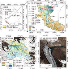
Fig. 1
The location of the Kyagar Basin"

Tab. 1
Data used in this study"
| 年份 | 数据集/传感器 | 影像日期/年-月-日 | 分辨率/m | 年份 | 数据集/传感器 | 影像日期/年-月-日 | 分辨率/m |
|---|---|---|---|---|---|---|---|
| 1990年 | Landsat-5 TM | 1990-03-09 | 30 | 2008年 | Landsat-5 TM | 2008-06-14 | 30 |
| 1991年 | Landsat-5 TM | 1991-07-02 | 30 | 2009年 | Landsat-7 EMT+ | 2009-07-27 | 30 |
| 1992年 | Landsat-5 TM | 1992-07-29 | 30 | Landsat-5 TM | 2009-07-28 | 30 | |
| 1993年 | Landsat-5 TM | 1993-07-07 | 30 | 2010年 | Landsat-5 TM | 2010-08-23 | 30 |
| 1994年 | Landsat-5 TM | 1994-08-27 | 30 | 2011年 | Landsat-5 TM | 2011-08-10 | 30 |
| 1995年 | Landsat-5 TM | 1995-01-18 | 30 | 2012年 | Landsat-7 EMT+ | 2012-08-20 | 30 |
| 1996年 | Landsat-5 TM | 1996-09-01 | 30 | 2013年 | Landsat-8 OLI | 2013-07-30 | 30 |
| 1997年 | Landsat-5 TM | 1997-07-18 | 30 | 2014年 | Landsat-8 OLI | 2014-07-01 | 30 |
| 1998年 | Landsat-5 TM | 1998-10-09 | 30 | 2015年 | GF-1 WFV2 | 2015-07-24 | 16 |
| Landsat-5 TM | 1998-10-25 | 30 | 2016年 | Landsat-7 EMT+ | 2016-07-14 | 30 | |
| Landsat-5 TM | 1998-11-03 | 30 | Landsat-7 EMT+ | 2016-07-30 | 30 | ||
| 1999年 | Landsat-7 EMT+ | 1999-07-09 | 30 | HJ1A CCD1 | 2016-08-02 | 30 | |
| 2000年 | Landsat-7 EMT+ | 2000-06-25 | 30 | HJ1A CCD1 | 2016-08-10 | 30 | |
| Landsat-7 EMT+ | 2000-07-27 | 30 | 2017年 | Landsat-8 OLI | 2017-08-10 | 30 | |
| 2001年 | Landsat-7 EMT+ | 2001-07-05 | 30 | Sentinel-2A/B MSI | 2017-08-31 | 10 | |
| 2002年 | Landsat-7 EMT+ | 2002-08-09 | 30 | 2018年 | Sentinel-2A/B MSI | 2018-08-06 | 10 |
| 2003年 | Landsat-7 EMT+ | 2003-08-12 | 30 | 2019年 | GF-6 WFV | 2019-07-25 | 16 |
| 2004年 | Landsat-7 EMT+ | 2004-09-15 | 30 | 2020年 | Sentinel-2A/B MSI | 2020-06-06 | 10 |
| 2005年 | Landsat-7 EMT+ | 2005-08-26 | 30 | 2021年 | Sentinel-2A/B MSI | 2021-07-16 | 10 |
| 2006年 | Landsat-7 EMT+ | 2006-07-19 | 30 | 2022年 | Sentinel-2A/B MSI | 2022-06-26 | 10 |
| 2007年 | Landsat-7 EMT+ | 2007-06-20 | 30 | 2023年 | Sentinel-2A/B MSI | 2023-08-30 | 10 |

Fig. 2
Peak discharge of Kyagar Glacial Lake outburst floods from 1990 to 2023 at Kaqun Station"
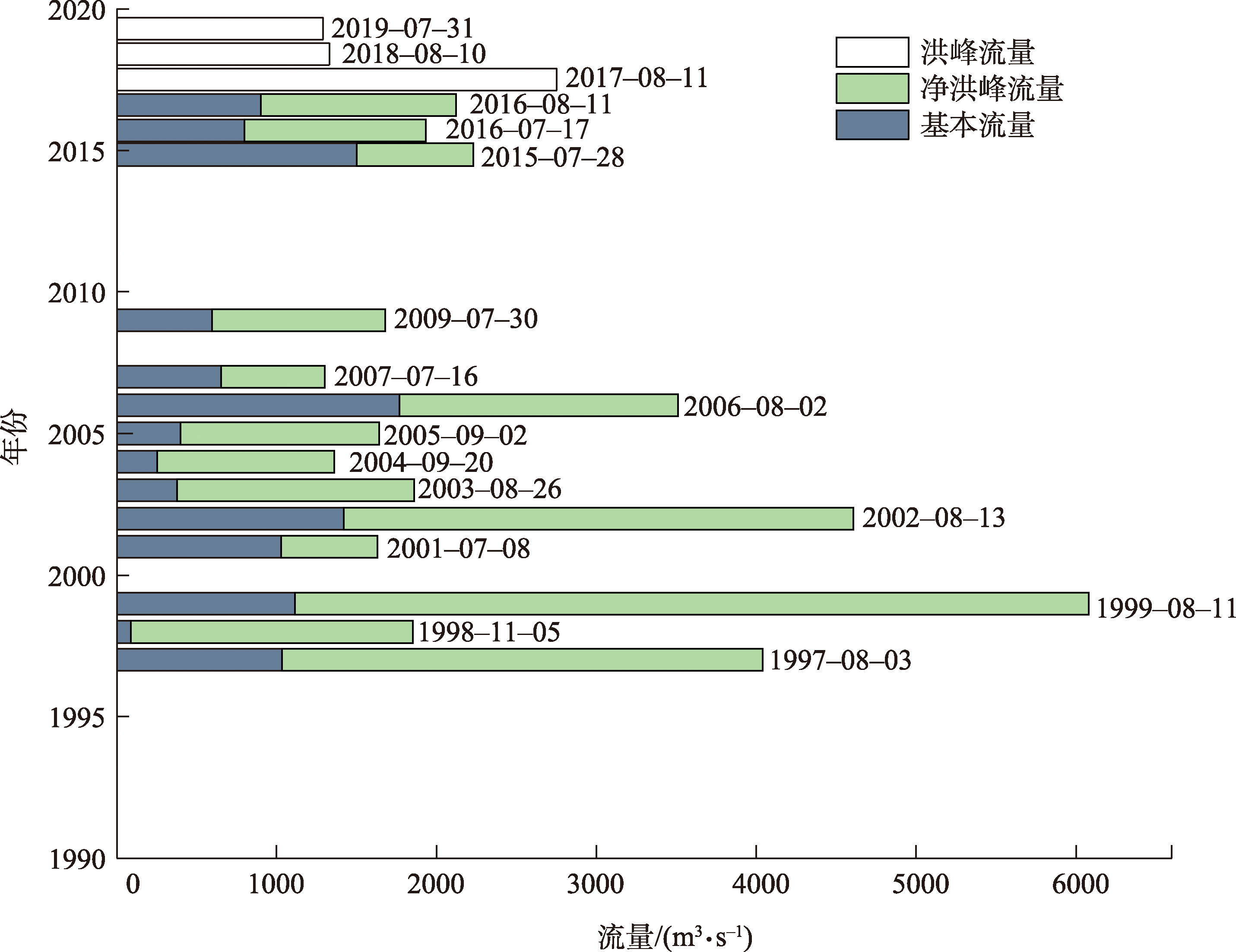
Tab. 2
The Kyagar Glacial Lake outburst floods from 1990 to 2023"
| 序号 | 年份 | 水文站 | 洪峰流量/(m3·s-1) | 基本流量/(m3·s-1) | 净洪峰流量/(m3·s-1) | 发生日期/月-日 | 文献来源 |
|---|---|---|---|---|---|---|---|
| 1 | 1997年 | 卡群站 | 4040 | 1033 | 3007 | 08-03 | [ |
| 2 | 1998年 | 卡群站 | 1850 | 88 | 1762 | 11-05 | [ |
| 3 | 1999年 | 卡群站 | 6070 | 1113 | 4967 | 08-11 | [ |
| 4 | 2001年 | 卡群站 | 1630 | 1026 | 604 | 07-08 | [ |
| 5 | 2002年 | 卡群站 | 4610 | 1420 | 3190 | 08-13 | [ |
| 6 | 2003年 | 卡群站 | 1860 | 377 | 1483 | 08-26 | [ |
| 7 | 2004年 | 卡群站 | 1360 | 253 | 1107 | 09-20 | [ |
| 8 | 2005年 | 卡群站 | 1640 | 396 | 1244 | 09-02 | [ |
| 9 | 2006年 | 卡群站 | 3510 | 1768 | 1742 | 08-02 | [ |
| 10 | 2007年 | 卡群站 | 1300 | 654 | 646 | 07-16 | [ |
| 11 | 2009年 | 卡群站 | 1680 | 595 | 1085 | 07-30 | [ |
| 12 | 2015年 | 库鲁克栏杆站 | 2230 | 1500 | 730 | 07-28 | [ |
| 13 | 2016年 | 库鲁克栏杆站 | 1930 | 798 | 1132 | 07-17 | [ |
| 14 | 库鲁克栏杆站 | 2120 | 900 | 1220 | 08-11 | [ | |
| 15 | 2017年 | 库鲁克栏杆站 | 2753 | - | - | 08-11 | [ |
| 16 | 2018年 | 卡群站 | 1330 | - | - | 08-10 | [ |
| 17 | 2019年 | 卡群站 | 1290 | - | - | 07-31 | [ |
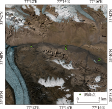
Fig. 3
The ICESat-2 satellite altimetry data at the measurement points within the lake basin"


Fig. 4
Monitoring of area variation and outburst flood events in the Kyagar Glacier-dammed Lake from 1990 to 2023"
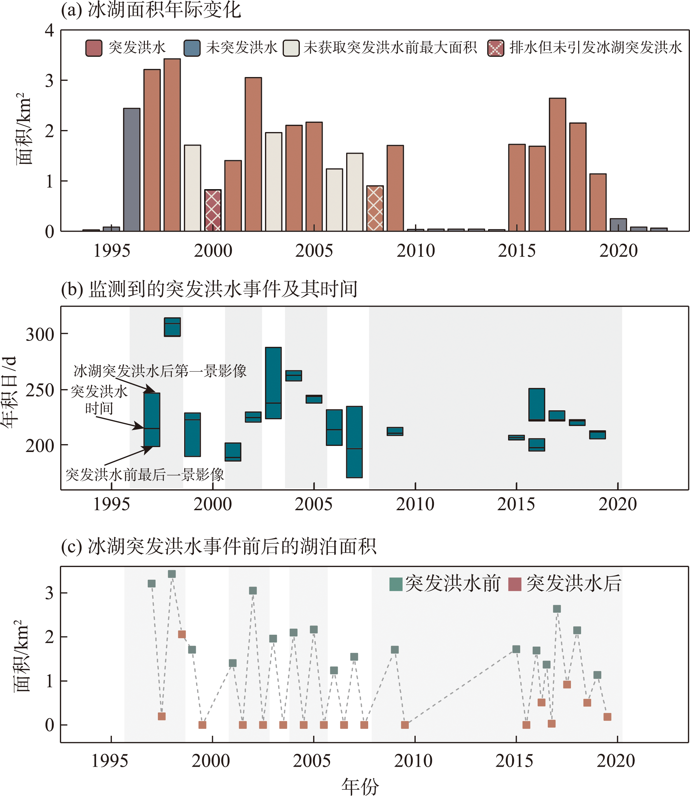
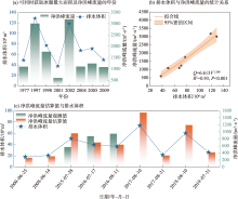
Fig. 5
Statistical relationship between lake volume and net peak discharge, and estimations of net peak discharge"

Tab. 3
Estimations of net peak discharge and relative error of glacial lake outburst floods"
| 日期/年-月-日 | 湖泊面积/km2 | 未完全排水剩余 湖泊面积/km2 | 排水体积 /106 m3 | 净洪峰流量估算值 /(m3·s-1) | 净洪峰流量观测值 /(m3·s-1) | 相对误差/% |
|---|---|---|---|---|---|---|
| 2015-07-28 | 1.72 | 50.61 | 958 | 569 | 68.39 | |
| 2016-07-17 | 1.69 | 0.51 | 39.54 | 701 | 876 | -20.00 |
| 2016-08-11 | 1.37 | 36.6 | 635 | 948 | -33.04 | |
| 2018-08-10 | 2.15 | 0.51 | 60.17 | 1193 | 316~716 | - |
| 2019-07-31 | 1.14 | 0.18 | 26.33 | 418 | 217~617 | - |
| 2000-06-25 | 0.82 | 18.2 | 262 | - | - | |
| 2008-06-14 | 0.90 | 20.62 | 307 | - | - | |
| 2017-08-10 | 2.64 | 0.92 | 73.8 | 1546 | - | - |
| 2017-08-31 | 1.33 | 0.65 | 21.75 | 328 | - | - |

Fig. 6
The sudden drainage processes of glacial lake outburst floods in 2000, 2008, and 2017"


Fig. 7
The alert drainage volume, alert area, and alert net peak discharge of the Kyagar Glacier-dammed Lake"

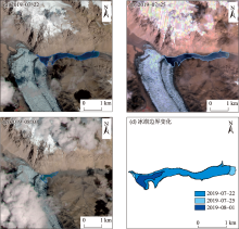
Fig. 8
The change process of Kyagar Glacier-dammed Lake before and after the outburst flood on July 31, 2019"

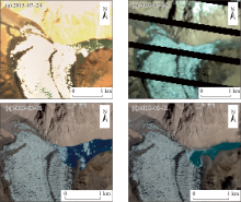
Fig. 9
Images before and after the outburst floods of the Kyagar Glacier-dammed Lake in 2015 and 2018"

| [1] | Allen S K, Linsbauer A, Randhawa S S, et al. Glacial lake outburst flood risk in Himachal Pradesh, India: An integrative and anticipatory approach considering current and future threats[J]. Natural Hazards, 2016, 84(3): 1741-1763. |
| [2] | Emmer A, Harrison S, Mergili M, et al. 70 years of lake evolution and glacial lake outburst floods in the Cordillera Blanca (Peru) and implications for the future[J]. Geomorphology, 2020, 365: 107178. |
| [3] | Zheng G, Allen S, Bao A, et al. Increasing risk of glacial lake outburst floods from future Third Pole deglaciation[J]. Nature Climate Change, 2021, 11: 411-417. |
| [4] |
Zheng G, Bao A, Allen S, et al. Numerous unreported glacial lake outburst floods in the Third Pole revealed by high-resolution satellite data and geomorphological evidence[J]. Science Bulletin, 2021, 66(13): 1270-1273.
doi: 10.1016/j.scib.2021.01.014 pmid: 36654147 |
| [5] | Round V, Leinss S, Huss M, et al. Surge dynamics and lake outbursts of Kyagar Glacier, Karakoram[J]. The Cryosphere, 2017, 11(2): 723-739. |
| [6] | 张祥松, 周聿超. 喀喇昆仑山叶尔羌河冰川湖突发洪水研究[M]. 北京: 科学出版社, 1990. |
| [Zhang Xiangsong, Zhou Yuchao. Research on Glacial Lake Outburst Floods in the Yarkand River of the Karakoram Mountains[M]. Beijing: Science Press, 1990.] | |
| [7] | 张祥松, 李念杰, 由希尧, 等. 新疆叶尔羌河冰川湖突发洪水研究[J]. 中国科学(B辑化学生命科学地学), 1989, 40(11): 1197-1204, 1233-1234. |
| [Zhang Xiangsong, Li Nianjie, You Xiyao, et al. A study on the sudden glacial lake outburst flood of the Yarkand River in Xinjiang[J]. Science in China (Series B: Chemistry, Life Sciences, Earth Sciences), 1989, 40(11): 1197-1204, 1233-1234.] | |
| [8] | Zhang M, Chen F, Tian B, et al. Characterization of Kyagar Glacier and lake outburst floods in 2018 based on time-series Sentinel-1A data[J]. Water, 2020, 12(1): 184. |
| [9] | Hewitt K. Tributary glacier surges: An exceptional concentration at Panmah Glacier, Karakoram Himalaya[J]. Journal of Glaciology, 2007, 53: 181. |
| [10] | 丁辉, 蔡向辉. 新疆叶尔羌河洪水发生规律分析[J]. 中国防汛抗旱, 2011, 94(1): 35-36, 43. |
| [Ding Hui, Cai Xianghui. Analysis of the flood occurrence pattern of the Yarkand River in Xinjiang[J]. China Flood & Drought Management, 2011, 94(1): 35-36, 43.] | |
| [11] | 袁波波, 彭亮, 姜卉芳. 叶尔羌河冰湖溃坝洪水早期预警系统参数的确定方法[J]. 水资源与水工程学报, 2014, 25(6): 82-85. |
| [Yuan Bobo, Peng Liang, Jiang Huifang. Method of parameter determination for early warning system (EWS) of outburst flood in glacial lake of Yarkant River[J]. Journal of Water Resources & Water Engineering, 2014, 25(6): 82-85.] | |
| [12] | 敖志刚, 丁辉. 中瑞叶尔羌河冰川湖洪水监测预警项目管理经验浅析[J]. 科技传播, 2014, 6(5): 166, 149. |
| [Ao Zhigang, Ding Hui. Preliminary analysis of the management experience of the Sino-Swiss glacial lake outburst flood monitoring and early warning project in the Yarkand River[J]. Science and Technology Communication, 2014, 6(5): 166, 149.] | |
| [13] | 彭亮, 敖志刚, 陈建江, 等. 喀喇昆仑山克亚吉尔冰川湖监测预警设计与应用[J]. 水资源与水工程学报, 2014, 25(5): 124-126, 131. |
| [Peng Liang, Ao Zhigang, Chen Jianjiang, et al. Design and application of monitoring and early warning to Kyagar Glacier lake in the Karakorum Mountain[J]. Journal of Water Resources & Water Engineering, 2014, 25(5): 124-126, 131.] | |
| [14] | Haemmig C, Huss M, Keusen H, et al. Hazard assessment of glacial lake outburst floods from Kyagar Glacier, Karakoram Mountains, China[J]. Annals of Glaciology, 2014, 55(66): 34-44. |
| [15] | 袁波波. 叶尔羌河冰川湖溃决洪水监测预警研究[D]. 乌鲁木齐: 新疆农业大学, 2015. |
| [Yuan Bobo. Study on Monitoring and Early Warning of Glacial Lake Outburst Floods in Yarkant River Basin[D]. Urumqi: Xinjiang Agricultural University, 2015.] | |
| [16] | 蒋紫云. 气候变化背景下克亚吉尔冰川运动对冰湖变化的影响研究[D]. 信阳: 信阳师范学院, 2023. |
| [Jiang Ziyun. Study on Kyagar Glacier Movement and Its Influence on Glacial Lake Variation Under Climate Change[D]. Xinyang: Xinyang Normal University, 2023.] | |
| [17] | Yan W, Liu J, Zhang M, et al. Outburst flood forecasting by monitoring glacier-dammed lake using satellite images of Karakoram Mountains, China[J]. Quaternary International, 2017, 453: 24-36. |
| [18] | Luo Y, Liu Q, Zhong Y, et al. Remote-sensing-based monitoring the dynamics of Kyagar Glacial Lake in the upstream section of Yarkant River, north Karakoram[J]. Land Degradation & Development, 2022, 34(3): 610-623. |
| [19] |
姚晓军, 刘时银, 魏俊锋. 喜马拉雅山北坡冰碛湖库容计算及变化——以龙巴萨巴湖为例[J]. 地理学报, 2010, 65(11): 1381-1390.
doi: 10.11821/xb201011008 |
|
[Yao Xiaojun, Liu Shiyin, Wei Junfeng. Reservoir capacity calculation and variation of moraine-dammed lakes in the North Himalayas: A case study of Longbasaba Lake[J]. Acta Geographica Sinica, 2010, 65(11): 1381-1390.]
doi: 10.11821/xb201011008 |
|
| [20] | 车涛, 晋锐, 李新, 等. 近20 a来西藏朋曲流域冰湖变化及潜在溃决冰湖分析[J]. 冰川冻土, 2004, 26(4): 397-402. |
| [Che Tao, Jin Rui, Li Xin, et al. Glacial lakes variation and analysis of potential outburst glacial lakes in the Pengqu River Basin, Tibet, over the past 20 years[J]. Journal of Glaciology and Geocryology, 2004, 26(4): 397-402.] | |
| [21] | 汪宙峰, 贺相綦, 王成武. 基于地理探测器与SVM的冰湖溃决预测研究——以喜马拉雅山地区为例[J]. 自然灾害学报, 2022, 31(6): 220-228. |
| [Wang Zhoufeng, He Xiangqi, Wang Chengwu. Prediction of glacial lake outburst floods based on geodetector and SVM: A case study of the Himalayan region[J]. Journal of Natural Disasters, 2022, 31(6): 220-228.] | |
| [22] | 吴坤鹏. 天山冰湖变化及其影响研究[D]. 湘潭: 湖南科技大学, 2015. |
| [Wu Kunpeng. The Change of Glacial Lake and Its Influence in Tianshan Mountains[D]. Xiangtan: Hunan University of Science and Technology, 2015.] | |
| [23] | Rinzin S, Zhang G, Wangchuk S. Glacial Lake area change and potential outburst flood hazard assessment in the Bhutan Himalaya[J]. Frontiers in Earth Science, 2021, 9: 775195. |
| [24] | 李治国, 姚檀栋, 叶庆华, 等. 1980—2007年喜马拉雅东段洛扎地区冰湖变化遥感研究[J]. 自然资源学报, 2011, 26(5): 836-846. |
| [Li Zhiguo, Yao Tandong, Ye Qinghua, et al. Monitoring glacial lake variations based on remote sensing in the Lhozhag District, Eastern Himalayas, 1980-2007[J]. Journal of Natural Resources, 2011, 26(5): 836-846.] | |
| [25] | Zhang T, Wang W, Gao T, et al. An integrative method for identifying potentially dangerous glacial lakes in the Himalayas[J]. Science of the Total Environment, 2022, 806: 150442. |
| [26] | Zhang Z, Zhao J, Liu S, et al. Characterization of three surges of the Kyagar Glacier, Karakoram[J]. Remote Sensing, 2023, 15(8): 2113. |
| [27] | 王杰, 马英杰. 新疆叶尔羌河溃坝洪水分析[J]. 中国水运(下半月), 2016, 16(6): 212-214. |
| [Wang Jie, Ma Yingjie. Analysis of dam break flood in the Yarkand River, Xinjiang[J]. China Water Transport (Part B), 2016, 16(6): 212-214.] | |
| [28] | Xie Z Y, Shangguan D H, Zhang S Q, et al. Index for hazard of glacier lake outburst flood of Lake Merzbacher by satellite-based monitoring of lake area and ice cover[J]. Global and Planetary Change, 2013, 107(5): 229-237. |
| [29] |
李达, 上官冬辉, 黄维东. 1998—2017年天山麦兹巴赫冰川湖面积变化研究[J]. 冰川冻土, 2020, 42(4): 1126-1134.
doi: 10.7522/j.issn.1000-0240.2019.0308 |
| [Li Da, Shangguan Donghui, Huang Weidong. Research on the area change of Lake Merzbacher in the Tianshan Mountains during 1998-2017[J]. Journal of Glaciology and Geocryology, 2020, 42(4): 1126-1134.] | |
| [30] | 郭万钦, 刘时银, 许君利, 等. 木孜塔格西北坡鱼鳞川冰川跃动遥感监测[J]. 冰川冻土, 2012, 34(4):765-774. |
| [Guo Wanqin, Liu Shiyin, Xu Junli, et al. Monitoring recent surging of the Yulinchuan Glacier on North slopes of Muztag Range by remote sensing[J]. Journal of Glaciology and Geocryology, 2012, 34(4): 765-774.] | |
| [31] |
孙永玲, 江利明, 柳林, 等. 基于Landsat-7 ETM+SLC-OFF影像的山地冰川流速提取与评估——以Karakoram锡亚琴冰川为例[J]. 冰川冻土, 2016, 38(3): 596-603.
doi: 10.7522/j.issn.1000-0240.2016.0066 |
|
[Sun Yongling, Jiang Liming, Liu Lin, et al. Surface flow velocity of mountain glaciers derived from Landsat-7 ETM+SLC-OFF images: Extraction and quantitative evaluation:A case study of the Siachen Glacier in the Karakoram[J]. Journal of Glaciology and Geocryology, 2016, 38(3): 596-603.]
doi: 10.7522/j.issn.1000-0240.2016.0066 |
|
| [32] |
努尔比亚·吐尼牙孜, 米日古丽·米吉提, 毛炜峄, 等. 1961—2021年叶尔羌河流域克亚吉尔冰湖溃决洪水变化特征[J]. 冰川冻土, 2023, 45(4): 1288-1299.
doi: 10.7522/j.issn.1000-0240.2023.0099 |
|
[Tunyaz Nurbiye, Mijit Mihrigul, Mao Weiyi, et al. Variation characteristics of Kyagar Glacial Lake outburst floods in the Yarkand River Basin from 1961 to 2021[J]. Journal of Glaciology and Geocryology, 2023, 45(4): 1288-1299.]
doi: 10.7522/j.issn.1000-0240.2023.0099 |
|
| [33] | 王杰. 叶尔羌河冰川湖溃决洪水与融雪型洪水的分型及组合研究[D]. 乌鲁木齐: 新疆农业大学, 2018. |
| [Wang Jie. Study on Typing and Combination of Glacial Lake Outburst Flood and Snowmelt Flood in Yarkand River Basin[D]. Urumqi: Xinjiang Agricultural University, 2018.] | |
| [34] | 杨静. 叶尔羌河库鲁克栏杆站-喀群站洪水传播时间规律[J]. 吉林水利, 2014(7): 57-59. |
| [Yang Jing. Law of flood propagation time in Kuluklangan station-Kaqun station in Yarkant River[J]. Jilin Water Resources, 2014(7): 57-59.] | |
| [35] |
孙步伟, 赵萍, 程雷, 等. 基于Munsell HSV变换的 TM 影像水体提取方法研究[J]. 遥感技术与应用, 2009, 24(6): 797-800.
doi: 10.11873/j.issn.1004-0323.2009.6.797 |
| [Sun Buwei, Zhao Ping, Cheng Lei, et al. Study on extraction method of water body from TM based on Munsell HSV transformation[J]. Remote Sensing Technology and Application, 2009, 24(6): 797-800.] | |
| [36] | Su C H, Chiu H S, Hsieh T M. An efficient image retrieval based on HSV color space[C]// International Conference on Electrical and Control Engineering. IEEE, 2011: 5746-5749. |
| [37] | Shean D. High Mountain Asia 8-meter DEMs derived from along-track optical imagery, version 1, user guide[EB/OL]. https://doi.org/10.5067/GSACB044M4PK, 2017. |
| [38] |
刘军彦, 王世杰. 基于ICESat-2卫星测高数据的呼伦湖水位变化监测[J]. 干旱区研究, 2023, 40(9): 1438-1445.
doi: 10.13866/j.azr.2023.09.07 |
|
[Liu Junyan, Wang Shijie. Monitoring of Hulun Lake water level changes based on ICESat-2 satellite altimetry data[J]. Arid Zone Research, 2023, 40(9): 1438-1445.]
doi: 10.13866/j.azr.2023.09.07 |
|
| [39] | 马云飞. 叶尔羌河冰川湖突发洪水变化特征及防御研究[D]. 乌鲁木齐: 新疆农业大学, 2022. |
| [Ma Yunfei. Characteristics and Prevention of Glacial Lake Outburst Flood the Yarkand River[D]. Urumqi: Xinjiang Agricultural University, 2022.] | |
| [40] | 牛竞飞, 刘景时, 王迪, 等. 2009年喀喇昆仑山叶尔羌河冰川阻塞湖及冰川跃动监测[J]. 山地学报, 2011, 29(3): 276-282. |
| [Niu Jingfei, Liu Jingshi, Wang Di, et al. Monitoring on ice-dammed lake and related surging glaciers in the Yarkant River, Karakoram in 2009[J]. Mountain Research, 2011, 29(3): 276-282.] | |
| [41] | Shangguan D, Ding Y, Liu S, et al. Quick release of internal water storage in a glacier leads to underestimation of the hazard potential of glacial lake outburst floods from lake Merzbacher in Central Tian Shan Mountains[J]. Geophysical Research Letters, 2017, 44(19): 9786-9795. |
| [1] | MA Yuanzhi, QIN Xiaolin, LING Hongbo, YAN Junjie, ZHANG Guangpeng. Spatio-temporal characteristics and trends of area changes in the small and medium-sized lakes in Xinjiang, China, from 1991 to 2020 [J]. Arid Zone Research, 2024, 41(6): 905-916. |
| [2] | WANG Zhen,LI Junli,BAO Anming,ZHANG Jiudan,BAI Jie. Temporal variation in the Barkol Lake area and its driving factors in 1995-2020 [J]. Arid Zone Research, 2021, 38(6): 1514-1523. |
| [3] |
HUANG Li, XU Li-ping.
Spatiotemporal Evolution of the Oasis and Change of Landscape Pattern in the Manas River Basin [J]. Arid Zone Research, 2019, 36(5): 1261-1269. |
| [4] | ZHU Ping, XIAO Jian-She, FU Yang. Analysis on Identification Characters of Storm Cells for Early Warning of Hail and Thunder Storms in the Northeast Qinghai-Tibetan Plateau [J]. , 2012, 29(6): 941-948. |
|
||