Arid Zone Research ›› 2021, Vol. 38 ›› Issue (4): 1104-1110.doi: 10.13866/j.azr.2021.04.22
• Plant and Plant Physiology • Previous Articles Next Articles
LI Ziyu( ),CHENG Qihui,HUANG Feng(),GUO Zhentian
Received:2021-01-26
Revised:2021-03-15
Online:2021-07-15
Published:2021-08-03
Contact:
Feng HUANG
E-mail:1034677728@qq.com;huangfeng1987@hhu.edu.cn
LI Ziyu,CHENG Qihui,HUANG Feng,GUO Zhentian. Spatiotemporal evolution of vegetation coverage in Alhagi sparsifolia Reserve in Turpan Basin, Xinjiang[J].Arid Zone Research, 2021, 38(4): 1104-1110.
Add to citation manager EndNote|Reference Manager|ProCite|BibTeX|RefWorks

Fig. 1
Location of Alhagi sparsifolia Reserve and distribution of sample points"
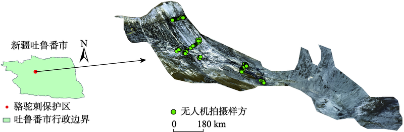
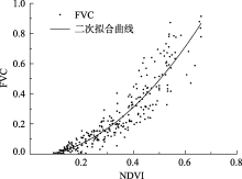
Fig. 2
Correlation curve between FVC and NDVI"

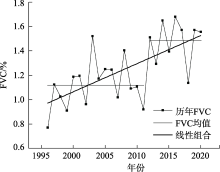
Fig. 3
Variation chart of FVC in Alhagi sparsifolia Reserve from 1996 to 2020"

Tab. 1
Area and ration of vegetation coverage change in the Alhagi sparsifolia Reserve"
| 区域 | 植被覆盖度/% | 面积/km2 | 面积比例/% |
|---|---|---|---|
| 显著改善区 | 9.84 | 200.46 | 20.14 |
| 不显著变化区 | 2.92 | 486.31 | 48.87 |
| 显著退化区 | 2.65 | 308.37 | 30.99 |

Fig. 4
Change trend of FVC in the Alhagi sparsifolia Reserve from 1996 to 2020"
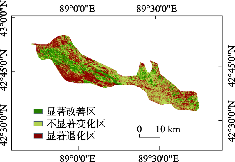

Fig. 5
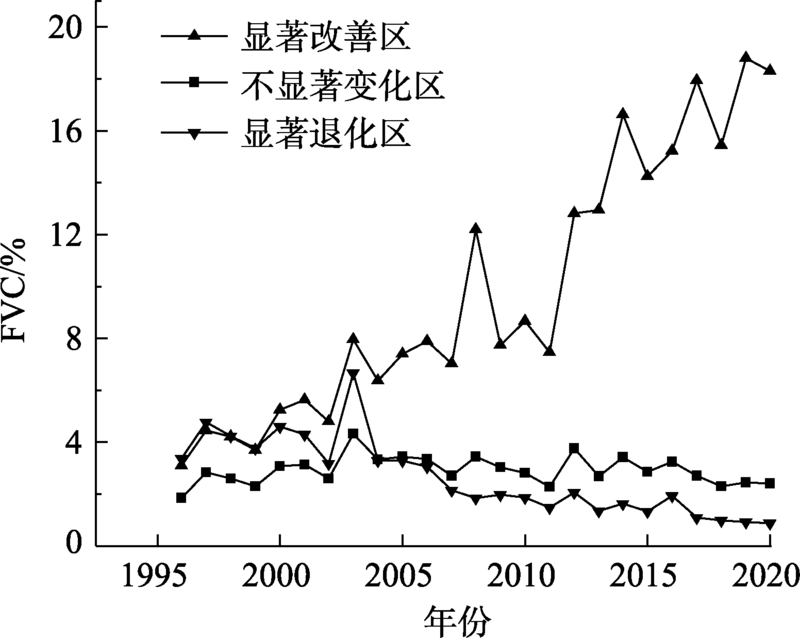
Variation of classified FVC in different areas of the Alhagi sparsifolia Reserve from 1996 to 2020"
| [1] | 罗瀚林, 曾凡江, 郭自春, 等. 春季与秋季刈割对疏叶骆驼刺叶片功能性状的影响[J]. 草业科学, 2016, 33(4):691-699. |
| [ Luo Hanlin, Zeng Fanjiang, Guo Zichun, et al. Influence of spring and fall clipping on the leaf functional traits of Alhagi Sparsifolia[J]. Pratacultural Science, 2016, 33(4):691-699. ] | |
| [2] | 邢著荣, 冯幼贵, 杨贵军, 等. 基于遥感的植被覆盖度估算方法述评[J]. 遥感技术与应用, 2009, 24(6):849-854. |
| [ Xing Zhurong, Feng Yougui, Yang Guijun, et al. Method of estimating vegatation coverage based on remote sensing[J]. Remote Sensing Technology and Application, 2009, 24(6):849-854. ] | |
| [3] | 程红芳, 章文波, 陈锋. 植被覆盖度遥感估算方法研究进展[J]. 国土资源遥感, 2008, 20(1):13-18. |
| [ Cheng Hongfang, Zhang Wenbo, Chen Feng. Advances in researches on application of remote sensing method to estimating vegetation coverage[J]. Remote Sensing for Land & Resources, 2008, 20(1):13-18. ] | |
| [4] | 郭玉川, 何英, 李霞. 基于MODIS的干旱区植被覆盖度反演及植被指数优选[J]. 国土资源遥感, 2011, 23(2):115-118. |
| [ Guo Yuchuan, He Ying, Li Xia. Remote sensing inversion of vegetation coverage and optimization of vegetation index based on modis data in arid area[J]. Remote Sensing for Land & Resources, 2011, 23(2):115-118. ] | |
| [5] | 古丽·加帕尔, 陈曦, 包安明. 干旱区荒漠稀疏植被覆盖度提取及尺度扩展效应[J]. 应用生态学报, 2009, 20(12):2925-2934. |
| [ Guli Jiapaer, Chen Xi, Bao Anming. Coverage extraction and upscaling of sparse desert vegetation in arid area[J]. Chinese Journal of Applied Ecology, 2009, 20(12):2925-2934. ] | |
| [6] | 陈晋, 陈云浩, 何春阳, 等. 基于土地覆盖分类的植被覆盖率估算亚像元模型与应用[J]. 遥感学报, 2001, 5(6):416-422. |
| [ Chen Jin, Chen Yunhao, He Chunyang, et al. Sub pixel model for vegetation fraction estimation based on land cover classification[J]. Journal of Remote Sensing, 2001, 5(6):416-422. ] | |
| [7] | 白彦. 呼伦贝尔沙地植被覆盖度变化遥感监测研究[D]. 呼和浩特: 内蒙古农业大学, 2013. |
| [ Bai Yan. Study on Vegetation Coverage Change of Hulunbeier Sand Land By Remote Sensing[D]. Hohhot: Inner Mongolia Agricultural University, 2013. ] | |
| [8] | 沈谦, 朱长明, 张新. GF-2支持下的干旱区稀疏植被区植被覆盖度估算[J]. 测绘通报, 2019(7):33-38. |
| [ Shen Qian, Zhu Changming, Zhang Xin. Fractional vegetation cover estimation in arid and rare vegetation area aided by GF-2 remote sensing data[J]. Bulletin of Surveying and Mapping, 2019(7):33-38. ] | |
| [9] |
何宝忠, 丁建丽, 张喆, 等. 新疆植被覆盖度趋势演变实验性分析[J]. 地理学报, 2016, 71(11):1948-1966.
doi: 10.11821/dlxb201611007 |
|
[ He Baozhong, Ding Jianli, Zhang Zhe, et al. Experimental analysis of spatial and temporal dynamics of fractional vegetation cover in Xinjiang[J]. Acta Geographica sinica, 2016, 71(11):1948-1966. ]
doi: 10.11821/dlxb201611007 |
|
| [10] | 覃志豪, 李文娟, 徐斌, 等. 陆地卫星TM6波段范围内地表比辐射率的估计[J]. 国土资源遥感, 2004, 16(3):28-32. |
| [ Qin Zhihao, Li Wenjuan, Xu Bin, et al. The estimation of land surface emissivity for landsat TM6[J]. Remote Sensing for Land & Resources, 2004, 16(3):28-32. ] | |
| [11] | 卞雪. 基于无人机低空遥感影像可见光波段的植被覆盖率研究[D]. 南京: 南京农业大学, 2017. |
| [ Bian Xue. Vegetation Coverage Calculation Using Remote Sensing Image of Unmanned Aerial Vehicle Based on Visible Spectrum[D]. Nanjing: Nanjing University, 2017. ] | |
| [12] | 高永平, 康茂东, 何明珠, 等. 基于无人机可见光波段对荒漠植被覆盖度提取的研究——以沙坡头地区为例[J]. 兰州大学学报(自然科学版), 2018, 54(6):770-775. |
| [ Gao Yongping, Kang Maodong, He Mingzhu, et al. Extraction of desert vegetation coverage based on visible light band information of unmanned aerial vehicle: A case study of Shapotou region[J]. Journal of Lanzhou University(Natural Sciences Edition), 2018, 54(6):770-775. ] | |
| [13] |
Elazab A, Raziel A. Ordóez, Savin R, et al. Detecting interactive effects of N fertilization and heat stress on maize productivity by remote sensing techniques[J]. European Journal of Agronomy, 2016, 73:11-24.
doi: 10.1016/j.eja.2015.11.010 |
| [14] | 万炜, 肖生春, 陈小红, 等. 无人机遥感在野外植被盖度调查中的应用——以阿拉善荒漠区灌木为例[J]. 干旱区资源与环境, 2018, 32(9):150-156. |
| [ Wan Wei, Xiao Shengchun, Chen Xiaohong, et al. Application of unmanned aerial vehicles to field vegetation coverage survey: A study of shrubs on Alxa desert[J]. Journal of Arid Land Resources and Environment, 2018, 32(9):150-156. ] | |
| [15] | 宋清洁, 崔霞, 张瑶瑶, 等. 基于小型无人机与MODIS数据的草地植被覆盖度研究——以甘南州为例[J]. 草业科学, 2017, 34(1):40-50. |
| [ Song Qingjie, Cui Xia, Zhang Yaoyao, et al. Grassland fractional vegetation cover analysis using small UVAs and MODIS: A case study in Gannan Prefecture[J]. Pratacultural Science, 2017, 34(1):40-50. ] | |
| [16] | 阿不都克依木·阿布力孜, 地里夏提·买买提, 阿布都沙塔尔·买买提明, 等. 吐鲁番盆地植被盖度变化的自然及人文耦合分析[J]. 新疆农业科学, 2007, 44(5):667-671. |
| [ Abudukeyimu Abulizi, Dilixiati Maimaiti, Abudushataer Maimaitiming, et al. Research of the natural vegetation coverage changes and humanities degrees combination in Turpan Basin[J]. Xinjiang Agricultural Sciences, 2007, 44(5):667-671. ] | |
| [17] | 张晓, 魏青军, 刘亮. 吐鲁番盆地地下水与植被的关系研究[J]. 山东国土资源, 2016, 32(7):42-48. |
| [ Zhang Xiao, Wei Qingjun, Liu Liang. Research on relation between groundwater and vegetation in Turpan Dasin[J]. Shandong Land and Resources, 2016, 32(7):42-48. ] | |
| [18] | 熊黑钢. 新疆资源环境与可持续发展[M]. 乌鲁木齐: 新疆大学出版社, 2001. |
| [ Xiong Heigang. Resources Environment and Sustainable Development in Xinjiang[M]. Urumqi: Xinjiang University Press, 2001. ] | |
| [19] |
Meyer G E, Neto J C. Verification of color vegetation indices for automated crop imaging applications[J]. Computers and Electronics in Agriculture, 2008, 63(2):282-293.
doi: 10.1016/j.compag.2008.03.009 |
| [20] | 郭轶斌, 郭威, 秦宇辰, 等. 基于Kappa系数的一致性检验及其软件实现[J]. 中国卫生统计, 2016, 33(1):169-170. |
| [ Guo Yibin, Guo Wei, Qin Yuchen, et al. Consistency test based on Kappa coefficient and its software implementation[J]. Chinese Journal of Health Statistics, 2016, 33(1):169-170. ] | |
| [21] | 李苗苗. 植被覆盖度的遥感估算方法研究[D]. 北京: 中国科学院研究生院遥感应用研究所, 2003. |
| [ Li Miaomiao. The Method of Vegetation Fraction Estimation by Remote Sensing[D]. Beijing: Mapping and Geographical Information System, 2003. ] | |
| [22] | 董振宁, 张良. 回归分析预测认识中的一个误区[J]. 统计与决策, 2007(9):135-136. |
| [ Dong Zhenning, Zhang Liang. A misunderstanding of regression analysis and prediction[J]. Statistics & Decision, 2007(9):135-136. ] | |
| [23] |
Qi J G, Chehbouni A R, Huete A R, et al. A modified soil adjusted vegetation index[J]. Remote Sensing of Environment, 1994, 48(2):119-126.
doi: 10.1016/0034-4257(94)90134-1 |
| [24] |
Carlson T N, Ripley D A. On the relation between NDVI, fractional vegetation cover, and leaf area index[J]. Remote Sensing of Environment, 1997, 62(3):241-252.
doi: 10.1016/S0034-4257(97)00104-1 |
| [25] | 杨嘉, 郭铌, 黄蕾诺, 等. 西北地区MODIS-NDVI指数饱和问题分析[J]. 高原气象, 2008, 27(4):896-903. |
| [ Yang Jia, Guo Ni, Huang Leinuo, et al. Analyses on MODIS-NDVI index saturation in Northwest China[J]. Plateau Meteorology, 2008, 27(4):896-903. ] | |
| [26] | 庞冉, 王文. 基于MODIS数据的吐鲁番盆地2001—2017年植被变化及水热组合影响分析[J]. 干旱区地理, 2020, 43(5):1242-1252. |
| [ Pang Ran, Wang Wen. Analysis of vegetation index changes and the influence of hydrothermal combination in Turpan Basin from 2001 to 2017 Based on MODIS Data[J]. Arid Land Geography, 2020, 43(5):1242-1252. ] | |
| [27] | 刘洋, 李诚志, 刘志辉, 等. 1982—2013年基于GIMMS—NDVI的新疆植被覆盖度时空变化[J]. 生态学报, 2016, 36(19):6198-6208. |
| [ Liu Yang, Li Chengzhi, Liu Zhihui, et al. Assessment of spatiotemporal variations in vegetation cover in Xinjiang from 1982 to 2013 based on GIMMS-NDVI[J]. Acta Ecologica Sinica, 2016, 36(19):6198-6208. ] | |
| [28] | 阿不力米提·阿不力克木, 周京武. 新疆吐鲁番盆地地表径流特征[J]. 冰川冻土, 2014, 36(3):717-723. |
| [ Abulimiti Abulikemu, Zhou Jingwu. Surface discharge characteristics of the Turpan Basin, Xinjiang[J]. Journal of Glaciology and Geocryology, 2014, 36(3):717-723. ] | |
| [29] | 张爱民, 郝天鹏, 周和平, 等. 新疆白杨河流域特征及生态植被需水分析[J]. 生态学报, 2021, 41(5):1-10. |
| [ Zhang Aimin, Hao Tianpeng, Zhou Heping, et al. Analysis on characteristics of Baiyang River Basin and water requirement of ecological vegetation in Xinjiang[J]. Acta Ecologica Sinica, 2021, 41(5):1-10. ] | |
| [30] | 王永兴. 吐鲁番盆地绿洲环境区划研究[J]. 干旱区地理, 1996, 19(2):30-36. |
| [ Wang Yongxing. Environmental regionalization of the oases in Turpan Basin[J]. Arid Land Geography, 1996, 19(2):30-36. ] | |
| [31] | 李均力, 肖昊, 沈占锋, 等. 2013—2018年塔里木河下游植被动态变化及其对生态输水的响应[J]. 干旱区研究, 2020, 37(4):985-992. |
| [ Li Junli, Xiao Hao, Shen Zhanfeng, et al. Vegetation changes during the 2013-2018 period and its response to ecological water transport in the lower reaches of the Tarim River[J]. Arid Zone Research, 2020, 37(4):985-992. ] | |
| [32] | 曹国亮, 李天辰, 陆垂裕, 等. 干旱区季节性湖泊面积动态变化及蒸发量——以艾丁湖为例[J]. 干旱区研究, 2020, 37(5):1095-1104. |
| [ Cao Guoliang, Li Tianchen, Lu Chuyu, et al. Dynamic variation and evaporation of seasonal lakes in arid areas: A case study for the Aiding Lake[J]. Arid Zone Research, 2020, 37(5):1095-1104. ] | |
| [33] | 陈颖, 邵伟玲, 曹萌, 等. 新疆夏季高温日数的变化特征及其影响因子[J]. 干旱区研究, 2020, 37(1):58-66. |
| [ Chen Ying, Shao Weiling, Cao Meng, et al. Variation of summer high temperature days and its affecting factors in Xinjiang[J]. Arid Zone Research, 2020, 37(1):58-66. ] |
| [1] | SUN Linlin, LIU Qiong, HUANG Guan, CHEN Yonghang, WEI Xin, GUO Yulin, ZHANG Taixi, GAO Tianyi, XU Yunhong. Analysis of surface solar radiation under different cloud conditions in Xinjiang and the surrounding “Belt and Road” regions [J]. Arid Zone Research, 2024, 41(9): 1480-1490. |
| [2] | JIAN Zhengbo, LUO Hao, SHAN Nana. A study on the spatial and temporal evolution and carbon effects of production-living-ecological in Xinjiang under carbon peak and carbon neutrality goals [J]. Arid Zone Research, 2024, 41(7): 1238-1248. |
| [3] | LIU Huaqing, WANG Bo, JIA Yanyan, XIE Xinran, ZHANG Wei. Characterization of the freezing injury to Juglans regia at different slope positions in the West Tianshan valley of Xinjiang, China [J]. Arid Zone Research, 2024, 41(6): 1079-1088. |
| [4] | MA Yuanzhi, QIN Xiaolin, LING Hongbo, YAN Junjie, ZHANG Guangpeng. Spatio-temporal characteristics and trends of area changes in the small and medium-sized lakes in Xinjiang, China, from 1991 to 2020 [J]. Arid Zone Research, 2024, 41(6): 905-916. |
| [5] | ZHANG Haozhe, XUE Yayong, MA Yuanyuan, XUE Guoxuan. Carbon sequestration potential of oasis ecosystem in Xinjiang, China [J]. Arid Zone Research, 2024, 41(6): 998-1009. |
| [6] | XU Chaojie, DOU Yan, MENG Qilin. Prediction of the standardized precipitation evapotranspiration index in the Xinjiang region using the EMD-GWO-LSTM model [J]. Arid Zone Research, 2024, 41(4): 527-539. |
| [7] | SI Qi, FAN Haoran, DONG Wenming, LIU Xinping. Landscape ecological risk assessment and prediction for the Yarkant River Basin, Xinjiang, China [J]. Arid Zone Research, 2024, 41(4): 684-696. |
| [8] | BAO Jiayu, LI Xianglong, HU Qiwen, LI Tao. Spatiotemporal characteristics of carbon emissions from energy consumption and the approach to energy structure adjustment in Xinjiang [J]. Arid Zone Research, 2024, 41(3): 490-498. |
| [9] | YAO Junqiang. Change in atmospheric and surface water resource in Xinjiang [J]. Arid Zone Research, 2024, 41(2): 181-190. |
| [10] | WU Mingjiang, QIU Juan, ZHENG Feng, LING Xiaobo, WANG Xinyu, YANG Yang, YANG Jiaxin, LIU Liqiang. Study on shrub species diversity and niche of wild fruit forest in Xinjiang [J]. Arid Zone Research, 2024, 41(12): 2094-2109. |
| [11] | XU Yunhong, LIU Qiong, CHEN Yonghang, WEI Xin, LIU Xin, ZHANG Taixi, SHAO Weiling, YANG Hequn, ZHANG Chengming. Impact of land cover variations on surface albedo in Xinjiang and its surrounding Central Asian region [J]. Arid Zone Research, 2024, 41(10): 1649-1661. |
| [12] | JIN Chenyang, DU Hongru. Characteristics of spatial and temporal changes and zoning of cultivated land resilience in Xinjiang [J]. Arid Zone Research, 2024, 41(10): 1778-1788. |
| [13] | LI Xiaofeng, HUI Tingting, LI Yaoming, MAO Jiefei, WANG Guangyu, FAN Lianlian. Effects of different grazing management strategies on plant diversity in the mountain grassland of Xinjiang, China [J]. Arid Zone Research, 2024, 41(1): 124-134. |
| [14] | WANG Xiang, LYU Haishen, ZHU Yonghua, GUO Chenyu. Application and comparison of two channel flood routing methods in Xinjiang mountainous areas [J]. Arid Zone Research, 2023, 40(8): 1240-1247. |
| [15] | WANG Chao, MA Zhancang, PAN Chengnan, WU Xingyue, SONG Wendan, YAN Ping. New records of Amaranthus in Xinjiang [J]. Arid Zone Research, 2023, 40(8): 1280-1288. |
|
||