Arid Zone Research ›› 2025, Vol. 42 ›› Issue (11): 1949-1965.doi: 10.13866/j.azr.2025.11.01
• Weather and Climate • Previous Articles Next Articles
Gulzar MOMIN1,2( ), YANG Tao1,3(), YANG Lianmei1, LU Xinyu1
Received:2025-03-25
Revised:2025-07-08
Online:2025-11-15
Published:2025-12-13
Contact:
YANG Tao
E-mail:gz2233711745@163.com;yd_yang@sina.com
Gulzar MOMIN, YANG Tao, YANG Lianmei, LU Xinyu. Precipitation characteristics in Yili River Basin at different time scales based on multisource precipitation fusion data[J].Arid Zone Research, 2025, 42(11): 1949-1965.
Add to citation manager EndNote|Reference Manager|ProCite|BibTeX|RefWorks
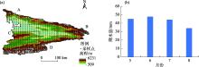
Fig. 1
Study area overview and multi-year monthly average precipitation"

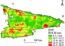
Fig. 2
Maximum hourly precipitation distribution in the warm season of the Ili River Basin from 2010 to 2021"

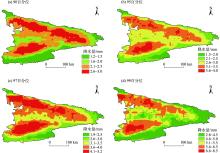
Fig. 3
Different percentile precipitation thresholds of hourly precipitation in Yili River Basin during the warm season from 2010 to 2021"

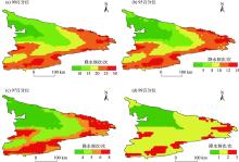
Fig. 4
Average annual frequency of hourly heavy precipitation at different percentiles in the Yili River Basin during the warm season from 2010 to 2021"
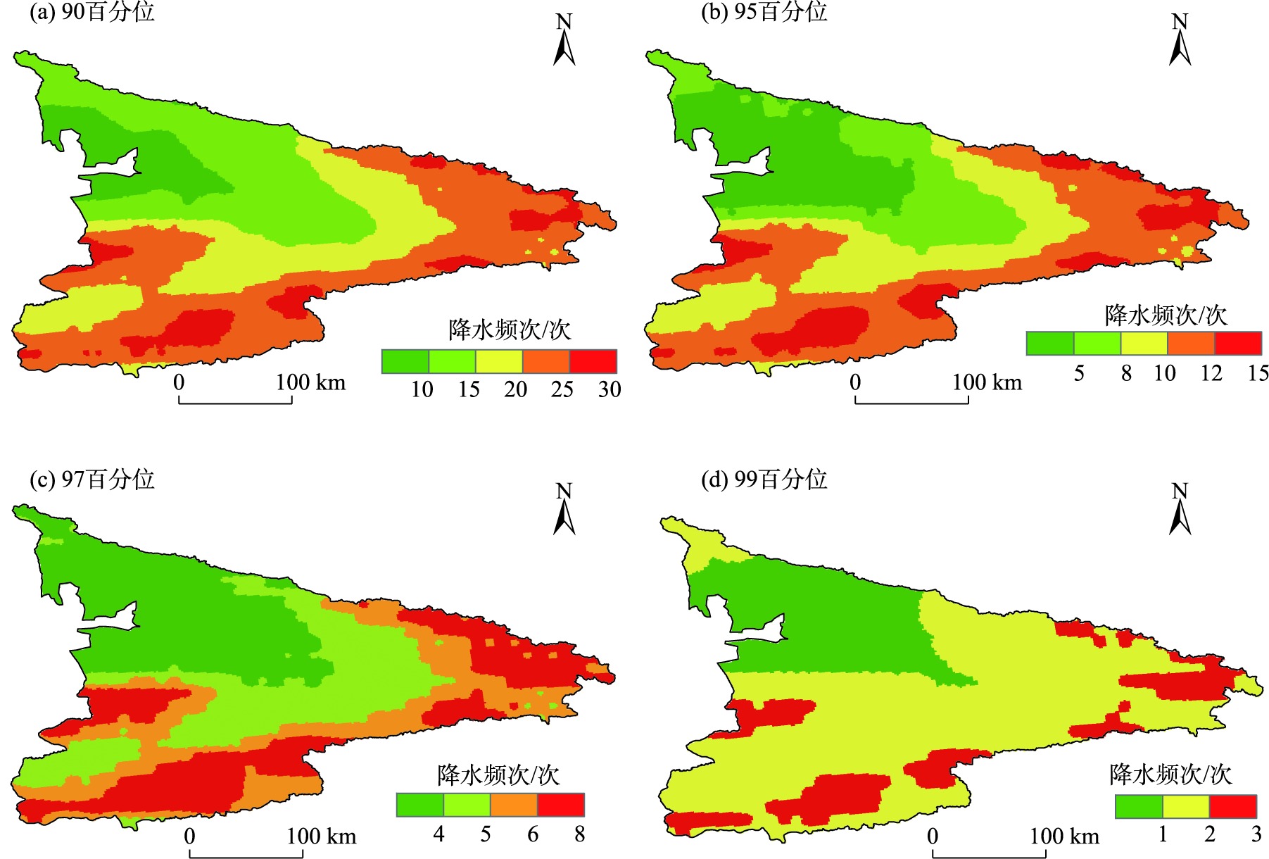
Fig. 5
Hourly heavy precipitation intensity at different percentiles in the Yili River Basin during the warm season from 2010 to 2021"

Fig. 6
Diurnal variation of extreme precipitation intensity at 1 h during the warm season in the Yili River Basin from 2010 to 2021"

Fig. 7
Diurnal variation of extreme precipitation frequency at 1 h during the warm season in the Yili River Basin from 2010 to 2021"

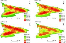
Fig. 8
Different percentile precipitation thresholds of 3 hourly precipitation in Yili River Basin during the warm season from 2010 to 2021"

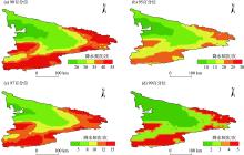
Fig. 9
Average annual frequency of heavy precipitation in 3 hours during the warm season in the Ili River Basin from 2010 to 2021"

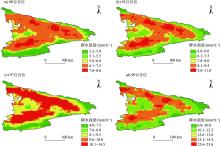
Fig. 10
In the warm season of 2010-2021, the intensity of heavy precipitation at different percentiles in each 3-hour period was different in Yili River Basin"

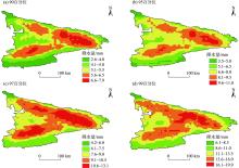
Fig. 11
Precipitation thresholds of different percentiles for each 6-hour period in the warm season of the Ili River Basin from 2010 to 2021"

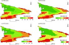
Fig. 12
Average annual frequency of heavy precipitation in 6 hours during the warm season in the Ili River Basin from 2010 to 2021"

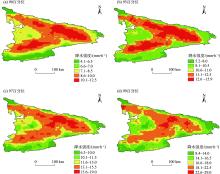
Fig. 13
In the warm season of 2010-2021, the intensity of heavy precipitation at different percentiles in each 6-hour period was different in Yili River Basin"

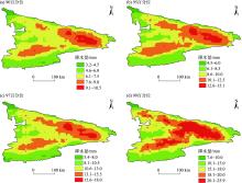
Fig. 14
Precipitation thresholds of different percentiles for each 12-hour period in the warm season of the Ili River Basin from 2010 to 2021"

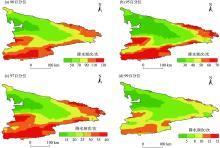
Fig. 15
Average annual frequency of heavy precipitation in 12 hours during the warm season in the Ili River Basin from 2010 to 2021"

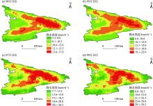
Fig. 16
In the warm season of 2010-2021, the intensity of heavy precipitation at different percentiles in each 12-hour period was different in Yili River Basin"

| [1] | 姚莉, 赵声蓉, 赵翠光, 等. 我国中东部逐时雨强时空分布及重现期的估算[J]. 地理学报, 2010, 65(5): 293-300. |
|
[ Yao Li, Zhao Shengrong, Zhao Cuiguang, et al. Temporal and spatial distributions of hourly rain intensity and recurrence periods in eastern and central China[J]. Acta Geographica Sinica, 2010, 65(3): 293-300. ]
doi: 10.11821/xb201003004 |
|
| [2] | 吕新生, 周雅蔓, 余行杰, 等. 1961—2019年新疆暴雨山洪灾害损失的时空变化特征[J]. 沙漠与绿洲气象, 2021, 15(4): 42-49. |
| [ Lyu Xinsheng, Zhou Yaman, Yu Xingjie, et al. Temporal and spatial variation characteristics of rainstorm torrential flood disaster loss in Xinjiang during 1961-2019[J]. Desert and Oasis Meteorology, 2021, 15(4): 42-49. ] | |
| [3] | 潘仕球, 唐小琴, 唐熠, 等. 桂北地区前汛期两次极端降水成因对比分析[J]. 气象研究与应用, 2023, 44(4): 36-43. |
| [ Pan Shiqiu, Tang Xiaoqin, Tang Yi, et al. Comparative analysis of the causes of two extreme heavy rainfalls during the previous flood season in northern Guangxi[J]. Journal of Meteorological Research and Application, 2023, 44(4): 36-43. ] | |
| [4] |
陈仁升, 沈永平, 毛炜峄, 等. 西北干旱区融雪洪水灾害预报预警技术: 进展与展望[J]. 地球科学进展, 2021, 36(3): 233-244.
doi: 10.11867/j.issn.1001-8166.2021.025 |
|
[ Chen Rensheng, Shen Yongping, Mao Weiyi, et al. Progress and issues on key technologies in forecasting of snowmelt flood disaster in arid areas, Northwest China[J]. Advances in Earth Science, 2021, 36(3): 233-244. ]
doi: 10.11867/j.issn.1001-8166.2021.025 |
|
| [5] | 刘晶, 周玉淑, 杨莲梅, 等. 伊犁河谷一次极端强降水事件水汽特征分析[J]. 大气科学, 2019, 43(5): 959-974. |
| [ Liu Jing, Zhou Yushu, Yang Lianmei, et al. A diagnostic study of water vapor during an extreme precipitation event in the Yili River Valley[J]. Chinese Journal of Atmospheric Sciences, 2019, 43(5): 959-974. ] | |
| [6] | 秦贺, 陈春艳, 阿不力米提江·阿布力克木, 等. 新疆暖季短时强降水特征[J]. 干旱区研究, 2019, 36(6): 1440-1449. |
| [ Qin He, Chen Chunyan, Ablimitijan Ablikim, et al. Characteristics of short duration heavy rainfall in warm season in Xinjiang[J]. Arid Zone Research, 2019, 36(6): 1440-1449. ] | |
| [7] |
许文涛, 唐文坚, 王协康, 等. 暴雨山洪监测技术研究进展与发展趋势[J]. 长江科学院院报, 2023, 40(4): 79-87.
doi: 10.11988/ckyyb.20211299 |
| [ Xu Wentao, Tang Wenjian, Wang Xiekang, et al. Research progress and development trend of heavy rainfall monitoring techniques during falsh flood process[J]. Journal of Changjiang River Scientific Research Institute, 2023, 40(4): 79-87. ] | |
| [8] | 詹昌洵, 张挺, 蒋嘉伟. 基于多源数据的山区小流域降水融合模型[J]. 水科学进展, 2025, 35(1): 74-84. |
| [ Zhan Changxun, Zhang Ting, Jiang Jiawei. Multi-source data-based precipitation fusion model for small mountainous watersheds[J]. Advances in Water Science, 2025, 35(1): 74-84. ] | |
| [9] | 覃晓东, 朱仟, 周东旸, 等. 基于深度学习的多源降水数据融合方法及其应用[J]. 人民长江, 2023, 54(11): 68-75. |
| [ Qin Xiaodong, Zhu Qian, Zhou Dongyang, et al. Mering multi-source precipitation data base on deep learning and its application[J]. Yangtze River, 2023, 54(11): 68-75. ] | |
| [10] | 袁子玥. 新疆伊犁河流域极端气候特征及其与植被生产力关系分析[D]. 呼和浩特: 内蒙古农业大学, 2024. |
| [ Yuan Ziyue. Analysis of Extreme Climate Characteristics and Its Relationship with Vegetation Productivity in Yili River Basin, Xinjiang[D]. Hohhot: Inner Mongolia Agricultural University, 2024. ] | |
| [11] | 李建, 宇如聪, 孙溦. 中国大陆地区小时极端降水阈值的计算与分析[J]. 暴雨灾害, 2013, 32(1): 11-16. |
| [ Li Jian, Yu Rucong, Sun Wei. Calculation and analysis of the thresholds of hourly extreme precipitation in China’s mainland[J]. Torrential Rain and Disasters, 2013, 32(1): 11-16. ] | |
| [12] | 陈妙霖, 毛文书, 师春香, 等. 1991—2020年西南湿季小时极端降水特征与区域差异[J]. 成都信息工程大学学报, 2022, 37(4): 435-441. |
| [ Chen Miaolin, Mao Wenshu, Shi Chunxiang, et al. Characteristics of hourly extreme precipitation in Southwest China from may to september from 1991 to 2020[J]. Journal of Chengdu University of Information Technology, 2022, 37(4): 435-441. ] | |
| [13] |
周雅蔓, 赵勇, 刘晶. 我国新疆北部地区夏季极端降水事件的特征分析[J]. 冰川冻土, 2020, 42(2): 598-608.
doi: 10.7522/j.issn.1000-0240.2019.0522 |
|
[ Zhou Yaman, Zhao Yong, Liu Jing. Analyzing on the characteristics of extreme summer precipitation events in northern Xinjiang[J]. Journal of Glaciology and Geocryology, 2020, 42(2): 598-608. ]
doi: 10.7522/j.issn.1000-0240.2019.0522 |
|
| [14] | 郭玉琳, 赵勇, 张同文, 等. 新疆天山山区夏季极端降水的日变化特征[J]. 沙漠与绿洲气象, 2023, 17(2): 44-51. |
| [ Guo Yulin, Zhao Yong, Zhang Tongwen, et al. Diurnal variation of summer extreme precipitation in Tianshan mountains of Xinjiang[J]. Desert and Oasis Meteorology, 2023, 17(2): 44-51. ] | |
| [15] | 杨莲梅, 张云惠, 黄艳, 等. 新疆短时极端降水诊断分析暨预报手册[M]. 北京: 气象出版社, 2020. |
| [ Yang Lianmei, Zhang Yunhui, Huang Yan, et al. Diagnostic Analysis and Forecast Manual of Short Term Heavy Precipitation in Xinjiang[M]. Beijing: China Meteorological Press, 2020. ] | |
| [16] | 曾勇, 杨莲梅. 新疆西部“6.16”强降水过程的中尺度分析[J]. 暴雨灾害, 2020, 39(1): 41-51. |
| [ Zeng Yong, Yang Lianmei. Mesoscale analysis on the “6.16” heavy precipitation event in the West of Xinjiang[J]. Torrential Rain and Disasters, 2020, 39(1): 41-51. ] | |
| [17] |
杨青, 姚俊强, 赵勇, 等. 伊犁河流域水汽含量时空变化及其和降水量的关系[J]. 中国沙漠, 2013, 33(4): 1174-1183.
doi: 10.7522/j.issn.1000-694X.2013.00166 |
| [ Yang Qing, Yao Junqiang, Zhao Yong, et al. Spatial-temproral varieation of water vapora and its relationship with the preciptation in the Ili river Basin[J]. Journal of Desert Research, 2013, 33(4): 1174-1183. ] | |
| [18] | 王颖慧, 丁建丽, 李晓航. 伊犁河流域土地利用/覆被变化对生态系统服务价值的影响——基于强度分析模型[J]. 生态学报, 2022, 42(8): 3106-3118. |
| [ Wang Yinghui, Ding Jianli, Li Xiaohang. Impact of LUCC on ecosystem services values in the Yili river Basin based on an intensity analysis model[J]. Acta Ecologica Sinica, 2022, 42(8) : 3106-3118. ] | |
| [19] | 杨霞, 张俊兰, 华烨, 等. 新疆伊犁河谷不同季节降水的日变化特征[J]. 干旱气象, 2021, 39(3): 394-405. |
| [ Yang Xia, Zhang Junlan, Hua Ye, et al. Diurnal variation characteristics of precipitation in different seasons in the Yili Valley of Xinjiang[J]. Journal of Arid Meteorology, 2021, 39(3): 394-405. ] | |
| [20] | 卢新玉, 刘艳, 王秀琴, 等. 新疆地区多源降水融合试验[J]. 干旱区研究, 2020, 37(5): 1223-1232. |
| [ Lu Xinyu, Liu Yan, Wang Xiuqin, et al. Multisource precipitation data merging experiment in Xinjiang[J]. Arid Zone Research, 2020, 37(5): 1223-1232. ] | |
| [21] |
李艳忠, 庄稼成, 白鹏, 等. 中国不同气候区多源遥感降水融合与性能综合评估[J]. 地理研究, 2022, 41(12): 3335-3351.
doi: 10.11821/dlyj020220206 |
| [ Li Yanzhong, Zhuang Jiacheng, Bai Peng, et al. Improving and comprehensive evaluation precipitation estimation by merging multi-satellite precipitation products in different climate regions of China[J]. Geographical Research, 2022, 41(12): 3335-3351. ] | |
| [22] | 曹孟, 刘艳丽, 陈鑫, 等. 基于星地融合降水的中小流域洪水模拟[J]. 水利水运工程学报, 2023(3): 47-56. |
| [ Cao Meng, Liu Yanli, Chen Xin, et al. Merging satellite and gauge precipitation for flood forecasting in a small and medium-sized watershed[J]. Hydro-Science and Engineering, 2023(3): 47-56. ] | |
| [23] | 龙柯吉, 王皓, 郭旭, 等. 夏季中国区域逐10分钟降水融合产品检验评估[J]. 成都信息工程大学学报, 2023, 38(1): 57-63. |
| [ Long Keji, Wang Hao, Guo Xu, et al. Validation and assessment of 10 mins merged precipitation product in China[J]. Journal of Chengdu University of Information Technology, 2023, 38(1): 57-63. ] | |
| [24] | 王福增, 温凯, 何山, 等. 多源降水量数据融合分析及评价[J]. 兰州大学学报(自然科学版), 2023, 59(5): 647-654. |
| [ Wang Fuzeng, Wen Kai, He Shan, et al. Analyis and evaluation of multi-source merging precipitation data[J]. Journal of Lanzhou University(Natural Sciences), 2023, 59(5): 647-654. ] | |
| [25] | 董旭光, 顾伟宗, 曹洁, 等. 山东省汛期小时极端强降水分布和变化特征[J]. 气象, 2017, 43(8): 953-961. |
| [ Dong Xuguang, Gu Weizong, Cao Jie, et al. Variation features of hourly precipitation in Shandong Province in flood season during 1961-2012[J]. Meteorogical Monthly, 2017, 43(8): 953-961. ] | |
| [26] |
杨霞, 周鸿奎, 赵克明, 等. 1991—2018年新疆夏季小时极端降水特征[J]. 高原气象, 2020, 39(4): 762-773.
doi: 10.7522/j.issn.1000-0534.2019.00114 |
| [ Yang Xia, Zhou Hongkui, Zhao Keming, et al. Variation features of hourly precipitation in Xinjiang Province during 1991-2018[J]. Plateau Meteorology, 2020, 39(4): 762-773. ] | |
| [27] | 杨春, 张勇, 张亚萍, 等. 近25 a重庆地区小时降水时空分布特征分析[J]. 暴雨灾害, 2020, 39(1): 71-80. |
| [ Yang Chun, Zhang Yong, Zhang Yaping, et al. Analysis on the characteristics of temporal and spatial distribution of hourly precipitation in Chongqing during recent 25 years[J]. Torrential Rain and Disasters, 2020, 39(1): 71-80. ] | |
| [28] |
陈圆圆, 宋晓东, 黄敬峰, 等. 基于地面站点观测降水资料的中国区域日降水融合产品精度评价[J]. 自然资源学报, 2016, 31(6): 1004-1014.
doi: 10.11849/zrzyxb.20150173 |
|
[ Chen Yuanyuan, Song Xiaodong, Huang Jingfeng, et al. Evaluation of the high-resolution daily merged precipitation product over China based on in situ observations[J]. Journal of Natural Resources, 2016, 31(6): 1004-1014. ]
doi: 10.11849/zrzyxb.20150173 |
|
| [29] | 李昕阳, 杜军凯, 胡新功, 等. 基于多种趋势分析方法的降水演变趋势分析[J]. 水电能源科学, 2023, 41(10): 14-18. |
| [ Li Xinyang, Du Junkai, Hu Xingong, et al. Trend analysis of precipitation evolution based on multiple trend analysis methods[J]. Water Resources and Power, 2023, 41(10): 14-18. ] |
| [1] | MENG Qingshuai, GONG Yu, LIU Xiaoyan, TONG Xin, WANG Dongmin, XIE Guoying, LIU Tingxi. Research and prediction of the degree of coupling coordination of water resources, socioeconomic development, and the ecological environment: A case of the Inner Mongolia section in the Yellow River Basin [J]. Arid Zone Research, 2025, 42(4): 682-694. |
|
||