Arid Zone Research ›› 2025, Vol. 42 ›› Issue (2): 333-348.doi: 10.13866/j.azr.2025.02.13
• Ecology and Environment • Previous Articles Next Articles
WANG Xumin1,2( ), GAO Xin1(), HU Zihao3, ZHOU Jie1
Received:2024-11-07
Revised:2024-11-26
Online:2025-02-15
Published:2025-02-21
Contact:
GAO Xin
E-mail:wangxumin22@mails.ucas.ac.cn;gaoxin@ms.xjb.ac.cn
WANG Xumin, GAO Xin, HU Zihao, ZHOU Jie. Effect of the Hotan River on the spatial pattern of surrounding eolian landforms in Xinjiang[J].Arid Zone Research, 2025, 42(2): 333-348.
Add to citation manager EndNote|Reference Manager|ProCite|BibTeX|RefWorks
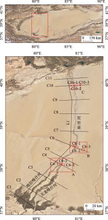
Fig. 1
Location diagram of a longitudinal profile, cross sections, and typical areas in the Hotan River Basin"

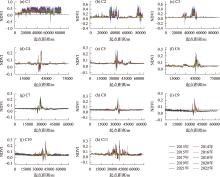
Fig. 2
NDVI variations along the cross-sections in the Hotan River Basin in 2013-2022"

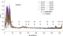
Fig. 3
Variation characteristics of NDVI along the longitudinal profile L1 in 2013-2022"

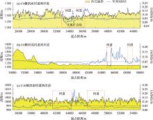
Fig. 4
Aeolian dune topography and NDVI variation characteristics on both sides of the Hotan River"

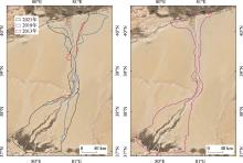
Fig. 5
Spatiotemporal variations of the influence area of the Hotan River on the surrounding aeolian landforms"

Tab. 1
Characteristics of the average wind conditions of the main meteorological stations around the Hotan River from 1991 to 2020"
| 位置 | 站点 | 最大风速/(m·s-1) | 平均风速/(m·s-1) | 盛行风向代号 | 盛行风向/(°) | 盛行风向频率/% |
|---|---|---|---|---|---|---|
| 北部 | 阿克苏 | 18.5 | 1.7 | 2 | 11.25~33.75 | 10 |
| 阿拉尔 | 13.1 | 1.4 | 3 | 33.75~56.25 | 13 | |
| 东部 | 策勒 | 10.0 | 1.3 | 13 | 258.75~281.25 | 12 |
| 于田 | 14.0 | 1.2 | 13 | 258.75~281.25 | 8 | |
| 民丰 | 16.0 | 1.6 | 3 | 33.75~56.25 | 12 | |
| 塔中 | 20.0 | 2.2 | 4 | 56.25~78.75 | 13 | |
| 南部 | 墨玉 | 11.7 | 1.3 | 15 | 303.75~326.25 | 7 |
| 和田 | 15.0 | 2.0 | 11 | 213.75~236.25 | 11 | |
| 洛浦 | 13.6 | 1.7 | 13 | 258.75~281.25 | 10 | |
| 西部 | 麦盖提 | 12.5 | 1.3 | 3 | 33.75~56.25 | 8 |
| 莎车 | 12.0 | 1.3 | 15 | 303.75~326.25 | 10 | |
| 皮山 | 13.5 | 1.5 | 15 | 303.75~326.25 | 10 |
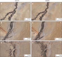
Fig. 6
Distribution patterns of fluvial and aeolian landforms in areas A, B, and C in 2013 and 2022"

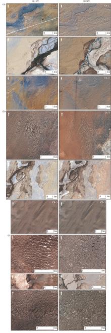
Fig. 7
Changes in river channel and aeolian landforms patterns in typical areas in 2013 and 2020"

Fig. 8
Lateral distribution pattern of Hotan River and surrounding aeolian landforms"


Fig. 9
Characteristics of channel sinuosity and gradient in different sections of the Hotan River"

Tab. 2
Spatiotemporal variations of channel sinuosity and gradient of the Hotan River and its tributaries"
| 河流 | 河段 | 河道弯曲度 | 弯曲度 变化率/% | 河道比降/‰ | 比降 变化率/% | ||
|---|---|---|---|---|---|---|---|
| 2013年 | 2022年 | 2013年 | 2022年 | ||||
| 喀拉喀什河 | C1~C2 | 1.117 | 1.126 | 0.81 | 1.234 | 1.223 | -0.89 |
| C2~C3 | 1.177 | 1.188 | 0.93 | 0.721 | 0.715 | -0.83 | |
| C3~C4 | 1.283 | 1.279 | -0.31 | 0.699 | 0.701 | 0.29 | |
| 玉龙喀什河 | C1~C2 | 1.133 | 1.121 | -1.06 | 2.664 | 2.694 | 1.13 |
| C2~C3 | 1.125 | 1.140 | 1.33 | 0.769 | 0.759 | -1.30 | |
| C3~C4 | 1.377 | 1.354 | -1.67 | 0.619 | 0.630 | 1.78 | |
| 和田河 | C4~C5 | 1.100 | 1.129 | 2.64 | 0.581 | 0.567 | -2.41 |
| C5~C6 | 1.090 | 1.151 | 5.60 | 0.639 | 0.605 | -5.32 | |
| C6~C7 | 1.162 | 1.169 | 0.60 | 0.605 | 0.602 | -0.50 | |
| C7~C8 | 1.054 | 1.049 | -0.47 | 0.640 | 0.643 | 0.47 | |
| C8~C9 | 1.061 | 1.065 | 0.38 | 0.594 | 0.592 | -0.34 | |
| C9~C10 | 1.037 | 1.034 | -0.29 | 0.639 | 0.640 | 0.16 | |
| C10~C11 | 1.167 | 1.147 | -1.71 | 0.600 | 0.610 | 1.67 | |
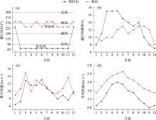
Fig. 10
Characteristics of the monthly average wind conditions at the north and south ends of the Hotan River from 1991 to 2020"

| [1] | 吴正. 风沙地貌与治沙工程学[M]. 北京: 科学出版社, 2003. |
| [Wu Zheng. Aeolian Landform and Sand Control Engineering[M]. Beijing: Science Press, 2003. ] | |
| [2] | El-Baz F, Maingue M, Robinson C. Fluvio-aeolian dynamics in the north-eastern Sahara: The relationship between fluvial/aeolian systems and ground-water concentration[J]. Journal of Arid Environments, 2000, 44(2): 173-183. |
| [3] | Smith N D, Smith D G. William River: An outstanding example of channel widening and braiding caused by bed-load addition[J]. Geology, 1984, 12(2): 78-82. |
| [4] | Bourke M C, Ewing R C, Finnegan D, et al. Sand dune movement in the Victoria Valley, Antarctica[J]. Geomorphology, 2009, 109(3-4): 148-160. |
| [5] | Liu B, Coulthard T J. Mapping the interactions between rivers and sand dunes: Implications for fluvial and aeolian geomorphology[J]. Geomorphology, 2015, 231: 246-257. |
| [6] | 宋阳, 刘连友, 严平. 风水复合侵蚀研究述评[J]. 地理学报, 2006, 61(1): 77-88. |
|
[Song Yang, Liu Lianyou, Yan Ping. A review on complex erosion by wind and water research[J]. Acta Geographica Sinica, 2006, 61(1): 77-88. ]
doi: 10.11821/xb200601008 |
|
| [7] | Bullard J E, Livingstone I. Interactions between aeolian and fluvial systems in dryland environments[J]. Area, 2002, 34(1): 8-16. |
| [8] | Krapf C B E, Stollhofen H, Stanistreet I G. Contrasting styles of ephemeral river systems and their interaction with dunes of the Skeleton Coast erg (Namibia)[J]. Quaternary International, 2003, 104(1): 41-52. |
| [9] | Field J P, Breshears D D, Whicker J J. Toward a more holistic perspective of soil erosion: why aeolian research needs to explicitly consider fluvial processes and interactions[J]. Aeolian Research, 2009, 1(1-2): 9-17. |
| [10] | Draut A E. Effects of river regulation on aeolian landscapes, Colorado River, southwestern USA[J]. Journal of Geophysics Research, 2012, 117: F02022. |
| [11] | Yu L P, Lai Z P, An P, et al. Aeolian sediments evolution controlled by fluvial processes, climate change and human activities since LGM in the Qaidam Basin, Qinghai-Tibetan Plateau[J]. Quaternary International, 2015, 372: 23-32. |
| [12] |
李永山, 彭文昌, 任亮, 等. 近50年黄河乌兰布和沙漠段辫状河道演变[J]. 中国沙漠, 2016, 36(6): 1689-1694.
doi: 10.7522/j.issn.1000-694X.2016.00175 |
|
[Li Yongshan, Peng Wenchang, Ren Liang, et al. Evolution of Ulan Buh Desert braided channel of the Yellow River in recent 50 years[J]. Journal of Desert Research, 2016, 36(6): 1689-1694. ]
doi: 10.7522/j.issn.1000-694X.2016.00175 |
|
| [13] | Kirkby M J. The Stream Head as A Significant Geomorphic Threshold[D]. Leeds, UK: University of Leeds, 1978. |
| [14] | Al-Masrahy M A, Mountney N P. A classification scheme for fluvial-aeolian system interaction in desert-margin settings[J]. Aeolian Research, 2015, 17: 67-88. |
| [15] | Zhao Y, Gao X, Lei J, et al. Interactions between paleochannels and aeolian processes and their implications on aeolian dune patterns[J]. Geomatics, Natural Hazards and Risk, 2019, 10(1): 1176-1192. |
| [16] | Song Q, Gao X, Lei J, et al. Spatial distribution of sand dunes and their relationship with fluvial systems on the southern margin of the Taklimakan Desert, China[J]. Geomatics, Natural Hazards and Risk, 2019, 10(1): 2408-2428. |
| [17] | Yan P, Li X M, Ma Y F, et al. Morphological characteristics of interactions between deserts and rivers in northern China[J]. Aeolian Research, 2015, 19: 225-233. |
| [18] |
李小妹, 严平. 中国北方地区沙漠与河流景观格局[J]. 地理科学进展, 2014, 33(9): 1198-1208.
doi: 10.11820/dlkxjz.2014.09.007 |
|
[Li Xiaomei, Yan Ping. Landscape pattern characteristics of deserts and rivers in Northern China[J]. Progress in Geography, 2014, 33(9): 1198-1208. ]
doi: 10.11820/dlkxjz.2014.09.007 |
|
| [19] | 朱震达, 陈治平, 吴正, 等. 塔克拉玛干沙漠风沙地貌研究[M]. 北京: 科学出版社, 1981. |
| [Zhu Zhenda, Chen Zhiping, Wu Zheng, et al. Research on Aeolian Landform in the Taklamakan Desert[M]. Beijing: Science Press, 1981. ] | |
| [20] | 朱震达, 吴正, 李钜章, 等. 塔克拉玛干沙漠风沙地貌研究[J]. 科学通报, 1966(13): 620-624. |
| [Zhu Zhenda, Wu Zheng, Li Juzhang, et al. Research on aeolian landform in the Taklamakan Desert[J]. Science Bulletin, 1966(13): 620-624.] | |
| [21] | Wang H, Jia X. Field observations of windblown sand and dust in the Taklimakan Desert, NW China, and insights into modern dust sources[J]. Land Degradation Development, 2013, 24(4): 323-333. |
| [22] | Zu R, Xue X, Qiang M, et al. Characteristics of near-surface wind regimes in the Taklimakan Desert, China[J]. Geomorphology, 2008, 96(1-2): 39-47. |
| [23] | 肖方, 李肖, 李承森, 等. 认识塔克拉玛干沙漠[J]. 生命世界, 2019(2): 52-53. |
| [Xiao Fang, Li Xiao, Li Chengsen, et al. Understanding the Taklamakan Desert[J]. The World of Life, 2019(2): 52-53. ] | |
| [24] | Shao Y, Dong C H. A review on East Asian dust storm climate, modelling and monitoring[J]. Global Planet Change, 2006, 52(1-4):1-22. |
| [25] | Zhang X Y, Gong S L, Zhao T L, et al. Sources of Asian dust and role of climate change versus desertification in Asian dust emission[J]. Geophysical Research Letters, 2003, 30(24): 5-8. |
| [26] | 余其鹰, 白云岗, 张江辉, 等. 和田河流域干流河道耗水过程分析[J]. 水资源与水工程学报, 2021, 32(2): 73-79. |
| [Yu Qiying, Bai Yungang, Zhang Jianghui, et al. Analysis of water consumption process in the main stream of Hotan River Basin[J]. Journal of Water Resources & Water Engineering, 2021, 32(2): 73-79. ] | |
| [27] | 韩兴胜, 陈雄波. 和田河河道冲淤特性分析[J]. 人民黄河, 2024, 46(S1): 26-28. |
| [Han Xingsheng, Chen Xiongbo. Analysis of erosion and deposition characteristics of Hotan River channel[J]. Yellow River, 2024, 46(S1): 26-28. ] | |
| [28] | 黄领梅, 沈冰. 和田河汇入塔里木河径流演变及成因分析[J]. 水资源与水工程学报, 2012, 23(2): 26-28. |
| [Huang Lingmei, Shen Bing. Analysis on runoff evolution and cause of Hotan River flowing into the Tarim River[J]. Journal of Water Resources & Water Engineering, 2012, 23(2): 26-28. ] | |
| [29] | 李卫红, 黎枫, 陈忠升, 等. 和田河流域平原耗水驱动力与适宜绿洲规模分析[J]. 冰川冻土, 2011, 33(5): 1161-1168. |
| [Li Weihong, Li Feng, Chen Zhongsheng, et al. Analysis of driving force of water consumption in plain and suitable scale of oasis in Hotan River Basin[J]. Journal of Glaciology and Geocryology, 2011, 33(5): 1161-1168. ] | |
| [30] |
夏婷婷, 薛璇, 王灏伟, 等. 昆仑山北坡陆地水储量变化及其驱动因素分析[J]. 干旱区地理, 2024, 47(8): 1292-1303.
doi: 10.12118/j.issn.1000-6060.2024.094 |
|
[Xia Tingting, Xue Xuan, Wang Haowei, et al. Changes in terrestrial water storage and its drivers on the north slope of Kunlun Mountains[J]. Arid Land Geography, 2024, 47(8): 1292-1303. ]
doi: 10.12118/j.issn.1000-6060.2024.094 |
|
| [31] |
刘鑫, 高鑫. 塔克拉玛干沙漠南缘新月形沙丘移动特征[J]. 干旱区研究, 2024, 41(4): 661-673.
doi: 10.13866/j.azr.2024.04.12 |
|
[Liu Xin, Gao Xin. Migration velocity of barchan dunes at the southern margin of the Taklamakan Desert[J]. Arid Zone Research, 2024, 41(4): 661-673. ]
doi: 10.13866/j.azr.2024.04.12 |
| [1] | LI Xiaodeng, CHANG Liang, DUAN Rui, WANG Qian, ZHANG Qunhui, YANG Bingchao. Analysis of the hydrochemistry characteristics and groundwater recharge sources in the Hotan River Basin, China [J]. Arid Zone Research, 2024, 41(6): 917-927. |
| [2] | LIU Xin, GAO Xin. Migration velocity of barchan dunes at the southern margin of the Taklamakan Desert [J]. Arid Zone Research, 2024, 41(4): 661-673. |
| [3] | ZHU Congzhen,ZHAO Tianliang,MENG Lu,YANG Xinghua,HE Qing,Ali MAMTIMIN,YANG Jie,ZHU Yan,WU Zhaoye. Different diurnal effects of floating dust on the structures in the atmospheric boundary layer over desert areas [J]. Arid Zone Research, 2022, 39(4): 1017-1026. |
| [4] | HUANG Xing,CHEN Fulong,ZHAO Qi,HE Chaofei,LONG Aihua. Evaluation and combination analysis of runoff in Hotan River, Xinjiang [J]. Arid Zone Research, 2021, 38(6): 1570-1578. |
| [5] | YU Qiying,ZHANG Jianghui,BAI Yungang,WANG Shuo,JIANG Zhu,CAO Biao,LU Zhenlin. Evolution characteristics of the headstream of the Hotan River headstream from 1957 to 2018 [J]. Arid Zone Research, 2021, 38(2): 494-503. |
| [6] | ZUO Min, CHEN Hong-wu, WANG Lei, FENG Zhi-min, WANG Hai-lei. Monitoring and Analysis on Overflow in the Hotan River Basin Based on MODIS Data [J]. , 2011, 28(3): 438-443. |
| [7] | FU Chao-feng, ZHAO Jing-bo. Distribution of Soil Moisture Content in Different Types of Sand Dunes in the Southeastern Marginal Zone of the Mu Us Sandy Land [J]. , 2011, 28(3): 377-383. |
|
||