Arid Zone Research ›› 2022, Vol. 39 ›› Issue (4): 1246-1258.doi: 10.13866/j.azr.2022.04.25
• Ecology and Environment • Previous Articles Next Articles
JIANG Xiaofang1,2( ),DUAN Hanchen1,3,LIAO Jie1,3,SONG Xiang1,3,XUE Xian1,3()
Received:2021-12-06
Revised:2022-03-23
Online:2022-07-15
Published:2022-09-26
Contact:
Xian XUE
E-mail:1695090635@qq.com;xianxue@lzb.ac.cn
JIANG Xiaofang,DUAN Hanchen,LIAO Jie,SONG Xiang,XUE Xian. Land use in the Gan-Lin-Gao region of middle reaches of Heihe River Basin based on a PLUS-SD coupling model[J].Arid Zone Research, 2022, 39(4): 1246-1258.
Add to citation manager EndNote|Reference Manager|ProCite|BibTeX|RefWorks
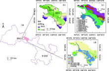
Fig. 1
Geographical location of the study area in Gansu Province (a), elevation (b), landform type (c) and the spatial distribution map of land use in 2015 (d)"

Tab. 1
Data source information of the research"
| 类型 | 数据 | 分辨率 | 来源 |
|---|---|---|---|
| 土地利用数据 | 土地利用数据(2000年、2015年) | 30 m | http://www.resdc.cn |
| 自然环境数据 | 年均气温(2015年) | 1 km | |
| 年均降水(2015年) | 1 km | ||
| 高程 | 30 m | ||
| 坡度 | 30 m | ||
| 坡向 | 30 m | ||
| 社会经济数据 | 人口(2015年) | 1 km | |
| GDP(2015年) | 1 km | ||
| 像元与道路的距离数据 | 30 m | ||
| 像元与河流的距离数据 | 30 m | ||
| 像元与居民点的距离数据 | 30 m |

Fig. 2
Flow chart of this study"
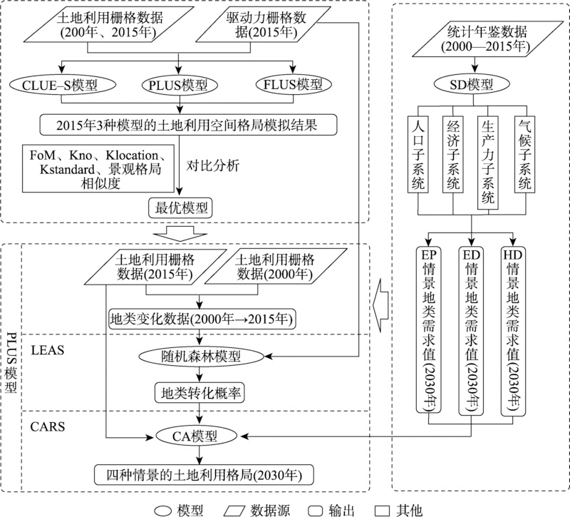
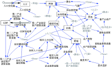
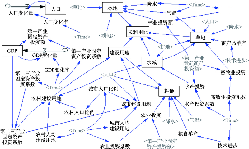
Fig. 3
Flow chart of SD model"
Tab. 2
Historical test of SD model’s simulation results /hm2"
| 检验 | 耕地 | 林地 | 草地 | 水域 | 城市建设用地 | 农村建设用地 | 未利用地 |
|---|---|---|---|---|---|---|---|
| 历史值(2015年) | 217147 | 11625 | 149341 | 24752 | 6974 | 15450 | 642389 |
| 模拟值(2015年) | 215784 | 11554 | 149322 | 24695 | 6938 | 14736 | 644650 |
| 相对误差/% | 0.63 | 0.61 | 0.01 | 0.23 | 0.51 | 4.62 | 0.35 |
Tab. 3
Parameter setting of different scenarios"
| 变量 | 人口增长率/‰ | GDP增长率/% | 年降雨变化/(mm·a-1) | 年均温变化/(℃·a-1) | 技术系数 | 城镇化率 |
|---|---|---|---|---|---|---|
| HD情景 | 6 | 12 | 0.350 | 0.020 | 400 | 43%线性增至61.8% |
| ED情景 | 10 | 14 | 0.550 | 0.030 | 500 | 43%线性增至65% |
| EP情景 | 4 | 9 | 0.15 | 0.010 | 500 | 43%线性增至60% |
Tab. 4
ROC index of CLUE-S model"
| 分辨率/m | 耕地 | 林地 | 草地 | 水域 | 城市建设用地 | 农村建设用地 | 未利用地 |
|---|---|---|---|---|---|---|---|
| 30 | 0.731 | 0.566 | 0.57 | 0.509 | 0.569 | 0.684 | 0.758 |
| 50 | 0.935 | 0.696 | 0.737 | 0.722 | 0.915 | 0.834 | 0.893 |
| 100 | 0.935 | 0.698 | 0.729 | 0.728 | 0.867 | 0.832 | 0.892 |
| 200 | 0.935 | 0.68 | 0.738 | 0.72 | 0.928 | 0.833 | 0.892 |
Tab. 5
Landscape data of simulation results of different models in 2015"
| 景观指数 | PLUS(50 m) | FLUS(50 m) | CLUE-S(50 m) | 实际(50 m) |
|---|---|---|---|---|
| NP (Number of patches) | 7122.00a | 20303.00c | 11957.00b | 4182.00 |
| LPI (Largest patch index)/% | 43.48c | 52.71a | 53.06b | 50.89 |
| PARA_MN (Mean perimeter-area ratio) | 456.47a | 613.45c | 536.94b | 231.18 |
| PARA_AM (Area-weighted mean perimeter-area ratio) | 36.94b | 63.30c | 36.17a | 33.58 |
| PARA_MD (Median perimeter-area ratio) | 366.67a | 640.00c | 600.00b | 222.22 |
| PARA_RA (Perimeter-area ratio range) | 790.01a | 776.04c | 790.70b | 789.71 |
| PARA_SD (Perimeter-area ratio standard deviation) | 266.51c | 206.07a | 250.83b | 123.03 |
| PARA_CV (Perimeter-area ratio coefficient of variation) | 58.38a | 33.59c | 46.72b | 53.22 |
| ENN_MN (Mean euclidean nearest neighbor distance)/m | 276.76a | 150.13c | 233.80b | 464.08 |
| ENN_AM (Area-weighted mean euclidean nearest neighbor distance)/m | 183.61b | 146.66a | 131.66c | 159.72 |
| ENN_MD (Median euclidean nearest neighbor distance)/m | 141.42a | 111.80c | 141.42a | 223.61 |
| ENN_RA (Euclidean nearest neighbor distance range)/m | 26382.45a | 20753.12c | 24047.88b | 34894.36 |
| ENN_SD (Euclidean nearest neighbor distance standard deviation)/m | 751.54a | 320.79c | 516.44b | 1087.47 |
| ENN_CV (Euclidean nearest neighbor distance coefficient of variation)/m | 271.55c | 213.68b | 220.89a | 234.33 |
| PLADJ (Percentage of like adjacencies)/% | 95.38b | 92.09c | 95.48a | 95.80 |
| Sim | 0.64 | 0.21 | 0.46 |
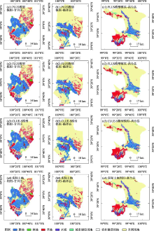
Fig. 4
Comparison of simulation results of different models in 2015"

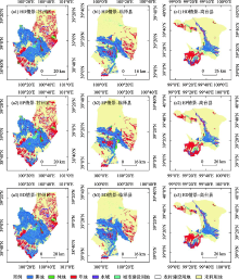
Fig. 5
Land use structure in different scenarios in 2030"

Tab. 6
Future prediction results of land use types under different scenarios /hm2"
| 类型 | 2015年 | SD模型(2030年) | ||
|---|---|---|---|---|
| ED情景 | EP情景 | HD情景 | ||
| 耕地 | 217147 | 261740 | 203469 | 225155 |
| 林地 | 11625 | 7958 | 14747 | 12165 |
| 草地 | 149341 | 137645 | 152568 | 146553 |
| 水域 | 24752 | 28097 | 25413 | 26704 |
| 城市建设用地 | 6974 | 14253 | 12070 | 13166 |
| 农村建设用地 | 15450 | 14732 | 14845 | 14690 |
| 未利用地 | 642389 | 603253 | 644568 | 629247 |
Tab. 7
Future land use transition matrix under different scenarios /hm2"
| 情景 | 2015年/2030年 | 耕地 | 林地 | 草地 | 水域 | 城市建设用地 | 农村建设用地 | 未利用地 | 总计 |
|---|---|---|---|---|---|---|---|---|---|
| ED情景 | 耕地 | 215340 | 18 | 272 | 239 | 292 | 0 | 987 | 217147 |
| 林地 | 2803 | 7648 | 421 | 112 | 68 | 0 | 573 | 11625 | |
| 草地 | 6215 | 82 | 134401 | 435 | 283 | 0 | 7924 | 149341 | |
| 水域 | 2825 | 27 | 718 | 17973 | 150 | 0 | 3059 | 24752 | |
| 城市建设用地 | 414 | 7 | 16 | 5 | 6430 | 0 | 103 | 6974 | |
| 农村建设用地 | 708 | 0 | 0 | 1 | 9 | 14732 | 0 | 15450 | |
| 未利用地 | 33435 | 175 | 1818 | 9332 | 7022 | 0 | 590606 | 642389 | |
| 总计 | 261740 | 7958 | 137645 | 28097 | 14253 | 14732 | 603253 | 1067678 | |
| EP情景 | 耕地 | 184921 | 6293 | 11703 | 2506 | 1943 | 26 | 9754 | 217147 |
| 林地 | 1341 | 6718 | 2020 | 150 | 106 | 0 | 1289 | 11625 | |
| 草地 | 4176 | 730 | 121801 | 1467 | 747 | 0 | 20419 | 149341 | |
| 水域 | 1271 | 112 | 1856 | 18428 | 99 | 1 | 2985 | 24752 | |
| 城市建设用地 | 246 | 32 | 94 | 5 | 6354 | 1 | 242 | 6974 | |
| 农村建设用地 | 491 | 9 | 19 | 5 | 50 | 14813 | 64 | 15450 | |
| 未利用地 | 11022 | 854 | 15074 | 2851 | 2770 | 3 | 609815 | 642389 | |
| 总计 | 203469 | 14747 | 152568 | 25413 | 12070 | 14845 | 644568 | 1067678 | |
| HD情景 | 耕地 | 217015 | 2 | 4 | 17 | 25 | 0 | 83 | 217147 |
| 林地 | 139 | 10715 | 11 | 133 | 54 | 0 | 572 | 11625 | |
| 草地 | 2181 | 48 | 146489 | 188 | 94 | 0 | 341 | 149341 | |
| 水域 | 176 | 60 | 17 | 21684 | 118 | 0 | 2697 | 24752 | |
| 城市建设用地 | 22 | 6 | 1 | 1 | 6874 | 0 | 70 | 6974 | |
| 农村建设用地 | 748 | 1 | 0 | 1 | 12 | 14690 | 0 | 15450 | |
| 未利用地 | 4874 | 1334 | 31 | 4679 | 5989 | 0 | 625483 | 642389 | |
| 总计 | 225155 | 12165 | 146553 | 26704 | 13166 | 14690 | 629247 | 1067678 |
| [1] | Turner B L. The sustainability principle in global agendas: Implications for understanding land use/cover change[J]. The Geographical Journal, 1997, 163(2): 114-133. |
| [2] |
Hyandye C. GIS and logit regression model applications in land use/land cover change and distribution in Usangu catchment[J]. American Journal of Remote Sensing, 2015, 3(1): 6-16.
doi: 10.11648/j.ajrs.20150301.12 |
| [3] |
Singh S K, Mustak S, Srivastava P K, et al. Predicting spatial and decadal LULC changes through cellular automata Markov chain models using earth observation datasets and geo-information[J]. Environmental Processes, 2015, 2(1): 61-78.
doi: 10.1007/s40710-015-0062-x |
| [4] |
Verburg P H, Soepboer W, Veldkamp A, et al. Modeling the spatial dynamics of regional land use: the CLUE-S model[J]. Environmental Management, 2002, 30(3): 391-405.
pmid: 12148073 |
| [5] | Filatova T, Verburg P H, Parker D C, et al. Spatial agent-based models for socio-ecological systems: Challenges and prospects[J]. Environmental Modelling & Software, 2013, 45: 1-7. |
| [6] |
严冬, 李爱农, 南希, 等. 基于Dyna-CLUE改进模型和SD模型耦合的山区城镇用地情景模拟研究——以岷江上游地区为例[J]. 地球信息科学学报, 2016, 18(4): 514-525.
doi: 10.3724/SP.J.1047.2016.00514 |
|
[Yan Dong, Li Ainong, Nan Xi, et al. The study of urban land scenario simulation in mountain area based on modified Dyna-CLUE model and SD: A case study of the upper reaches of Minjiang River[J]. Journal of Geo-Information Science, 2016, 18(4): 514-525.]
doi: 10.3724/SP.J.1047.2016.00514 |
|
| [7] |
田贺, 梁迅, 黎夏, 等. 基于SD模型的中国2010-2050年土地利用变化情景模拟[J]. 热带地理, 2017, 37(4): 547-561.
doi: 10.13284/j.cnki.rddl.002939 |
|
[Tian He, Liang Xun, Li Xia, et al. Simulating multiple land use scenarios in China during 2010-2050 based on system dynamic model[J]. Tropical Geography, 2017, 37(4): 547-561.]
doi: 10.13284/j.cnki.rddl.002939 |
|
| [8] | 何春阳, 史培军, 陈晋, 等. 基于系统动力学模型和元胞自动机模型的土地利用情景模型研究[J]. 中国科学(D辑: 地球科学), 2005, 35(5): 464-473. |
| [He Chunyang, Shi Peijun, Chen Jin, et al. Research on land use scenario model based on system dynamics model and cellular automata model[J]. Science in China Ser. D Earth Sciences, 2005, 35(5): 464-473.] | |
| [9] | 黎夏, 刘小平. 基于案例推理的元胞自动机及大区域城市演变模拟[J]. 地理学报, 2007, 62(10): 1097-1109. |
| [Li Xia, Liu Xiaoping. Case-based cellular automation for simulating urban development in a large complex region[J]. Acta Geographic Sinica, 2007, 62(10): 1097-1109.] | |
| [10] |
Luo G, Yin C, Chen X, et al. Combining system dynamic model and CLUE-S model to improve land use scenario analyses at regional scale: A case study of Sangong watershed[J]. Ecological Complexity, 2010, 7(2): 198-207.
doi: 10.1016/j.ecocom.2010.02.001 |
| [11] |
Peter H V, Koen P O. Combining top-down and bottom-up dynamics in land use modeling: Exploring the future of abandoned farmlands in Europe with the Dyna-CLUE model[J]. Landscape Ecology, 2009, 24(9): 1167-1181.
doi: 10.1007/s10980-009-9355-7 |
| [12] | Olmedo M T C, Jr R G P, Paegelow M, et al. Comparison of simulation models in terms of quantity and allocation of land change[J]. Environmental Modelling & Software, 2015, 69: 214-221. |
| [13] |
戴尔阜, 马良. 土地变化模型方法综述[J]. 地理科学进展, 2018, 37(1): 152-162.
doi: 10.18306/dlkxjz.2018.01.016 |
|
[Dai Erfu, Ma Liang. Review on land change modeling approaches[J]. Progress in Geography, 2018, 37(1): 152-162.]
doi: 10.18306/dlkxjz.2018.01.016 |
|
| [14] | 余强毅, 吴文斌, 唐华俊, 等. 复杂系统理论与Agent模型在土地变化科学中的研究进展[J]. 地理学报, 2011, 66(11): 1518-1530. |
| [Yu Qiangyi, Wu Wenbin, Tang Huajun, et al. Complex system theory and agent-based modeling: Progresses in land change science[J]. Acta Geographic Sinica, 2011, 66(11): 1518-1530.] | |
| [15] |
He X D, Mai X M, Shen G Q. Delineation of urban growth boundaries with SD and CLUE-S models under multi-scenarios in Chengdu Metropolitan Area[J]. Sustainability, 2019, 11(21): 5919.
doi: 10.3390/su11215919 |
| [16] |
Liang Y, Liu L, Huang J. Integrating the SD-CLUE-S and InVEST models into assessment of oasis carbon storage in northwestern China[J]. Plos One, 2017, 12(2): e0172494..
doi: 10.1371/journal.pone.0172494 |
| [17] |
Ding Q, Chen Y, Bu L, et al. Multi-scenario analysis of habitat quality in the Yellow River Delta by coupling FLUS with InVEST model[J]. International Journal of Environmental Research and Public Health, 2021, 18(5): 2389.
doi: 10.3390/ijerph18052389 |
| [18] | Liang X, Guan Q, Clarke K C, et al. Understanding the drivers of sustainable land expansion using a patch-generating land use simulation (PLUS) model: A case study in Wuhan, China[J]. Computers, Environment and Urban Systems, 2021, 85: 1-14. |
| [19] |
Verburg P H, Veldkamp T, Bouma J. Land use change under conditions of high population pressure: the case of Java[J]. Global Environmental Change, 1999, 9(4): 303-312.
doi: 10.1016/S0959-3780(99)00175-2 |
| [20] |
Liu X, Liang X, Li X, et al. A future land use simulation model (FLUS) for simulating multiple land use scenarios by coupling human and natural effects[J]. Landscape Urban Plan, 2017, 168: 94-116.
doi: 10.1016/j.landurbplan.2017.09.019 |
| [21] | Peng K, Jiang W, Deng Y, et al. Simulating wetland changes under different scenarios based on integrating the random forest and CLUE-S models: A case study of Wuhan Urban Agglomeration[J]. Ecological Indicators, 2020, 117: 1-13. |
| [22] |
Moulds S, Buytaert W, Mijic A. An open and extensible framework for spatially explicit land use change modelling: The lulcc R package[J]. Geoscientific Model Development, 2015, 8(10): 3215-3229.
doi: 10.5194/gmd-8-3215-2015 |
| [23] | 林丽, 樊辉, 金缘. 山区县域土地利用/覆被变化多尺度多模型模拟对比——以云南省勐腊县为例[J]. 山地学报, 2020, 38(4): 630-642. |
| [Lin Li, Fan Hui, Jin Yuan. Multi-scale and multi-model simulation of land use/land cover change in the mountainous county: A case study of Mengla County in Yunnan Province, China[J]. Mountain Research, 2020, 38(4): 630-642.] | |
| [24] | 张勃, 毛彦成, 柳景峰. 黑河中游土地利用/覆盖变化驱动力的定量分析[J]. 干旱区地理, 2006, 29(5): 726-730. |
| [Zhang Bo, Mao Yancheng, Liu Jingfeng. Analysis driving forces of LUCC in Heihe middle reaches[J]. Arid Land Geography, 2006, 29(5): 726-730.] | |
| [25] |
Pontius R G, Schneider L C. Land-cover change model validation by an ROC method for the Ipswich watershed, Massachusetts, USA[J]. Agriculture, Ecosystems and Environment, 2001, 85(1-3): 239-248.
doi: 10.1016/S0167-8809(01)00187-6 |
| [26] |
Pontius R G, Boersma W, Castella J, et al. Comparing the input, output, and validation maps for several models of land change[J]. The Annals of Regional Science, 2007, 42(1): 11-37.
doi: 10.1007/s00168-007-0138-2 |
| [27] |
Pontius R G, Millones M. Death to Kappa: Birth of quantity disagreement and allocation disagreement for accuracy assessment[J]. International Journal of Remote Sensing, 2011, 32(15): 4407-4429.
doi: 10.1080/01431161.2011.552923 |
| [28] |
Chen Y, Li X, Liu X, et al. Capturing the varying effects of driving forces over time for the simulation of urban growth by using survival analysis and cellular automata[J]. Landscape Urban Plan, 2016, 152: 59-71.
doi: 10.1016/j.landurbplan.2016.03.011 |
| [29] | Pontius R G. Quantification error versus location error in comparison of categorical maps[J]. Photogrammetric Engineering and Remote Sensing, 2000, 66(8): 1011-1016. |
| [30] | 李秀霞, 徐龙, 江恩赐. 基于系统动力学的土地利用结构多目标优化[J]. 农业工程学报, 2013, 29(16): 247-254. |
| [Li Xiuxia, Xu Long, Jiang Enci. Multi-objective optimization of land use structure in western Jilin Province based on system dynamics[J]. Transactions of the Chinese Society of Agricultural Engineering, 2013, 29(16): 247-254.] | |
| [31] | 国家统计局. 中国统计年鉴[M]. 北京: 中国统计出版社, 2000-2015. |
| [National Bureau of Statistics. China Statistical Yearbook[M]. Beijing: China Statistics Press, 2000-2015.] | |
| [32] | 张掖年鉴编纂委员会. 张掖年鉴[M]. 甘肃: 敦煌文艺出版社, 2000-2015. |
| [Zhangye Yearbook Editorial Board. Zhangye yearbook[M]. Gansu: Dunhuang Literature and Art Publishing House, 2000-2015.] | |
| [33] | 甘肃年鉴编纂委员会. 甘肃发展年鉴[M]. 北京: 中国统计出版社, 2000-2015. |
| [Gansu Development Yearbook Editorial Board. Gansu Development Yearbook[M]. Beijing: China Statistics Press, 2000-2015.] | |
| [34] | 国家统计局城市社会经济调查司. 中国城市发展年鉴[M]. 北京: 中国统计出版社, 2000-2015. |
| [Department of Urban Society and Economic Statistics National Bureau of Statistics of China. China City Statistical Yearbook[M]. Beijing: China Statistics Press, 2000-2015.] | |
| [35] | IPCC. Climate Change 2013:The Physical Science Basis. Contribution of Working Group I to the Fifth Assessment Report of the Intergovernmental Panel on Climate Change[R]. Cambridge and New York: Cambridge University Press, 2013: 159-254. |
| [36] | 梁友嘉, 徐中民, 钟方雷. 基于SD和CLUE-S模型的张掖市甘州区土地利用情景分析[J]. 地理研究, 2011, 30(3): 564-576. |
| [Liang Youjia, Xu Zhongmin, Zhong Fanglei. Land use scenario analyses by based on system dynamic model and CLUE-S model at regional scale: A case study of Ganzhou district of Zhangye City[J]. Geographic Research, 2011, 30(3): 564-576.] | |
| [37] | 刘玉钢, 王立宇. 济南市土地利用变化模拟预测研究[J]. 国土与自然资源研究, 2021(1): 47-50. |
| [Liu Yugang, Wang Liyu. Research on simulation and prediction of land use change in Jinan City[J]. Territory & Natural Resources Study, 2021(1): 47-50.] | |
| [38] | 张永民, 周成虎, 郑纯辉, 等. 沽源县土地利用格局的多尺度模拟与分析[J]. 资源科学, 2006, 28(2): 88-96. |
| [Zhang Yongmin, Zhou Chenghu, Zheng Chunhui, et al. Spatial land use patterns in Guyuan County: Simulation and analysis at multi-scale levels[J]. Resources Science, 2006, 28(2): 88-96.] | |
| [39] |
Saysel A K, Barlas Y, Yenigün O. Environmental sustainability in an agricultural development project: A system dynamics approach[J]. Journal of Environmental Management, 2002, 64(3): 247-260.
pmid: 12040958 |
| [40] | 苏迎庆, 刘庚, 赵景波, 等. 基于FLUS模型的汾河流域生态空间多情景模拟预测[J]. 干旱区研究, 2021, 38(4): 1152-1161. |
| [Su Yingqing, Liu Geng, Zhao Jingbo, et al. Multi-scenario simulation prediction of ecological space in the Fenhe River Basin using the FLUS model[J]. Arid Zone Research, 2021, 38(4): 1152-1161.] | |
| [41] | 金梦婷, 徐丽萍, 徐权. 基于FLUS-Markov模型的多情景景观生态风险评价与预测——以南疆克州为例[J]. 干旱区研究, 2021, 38(6): 1793-1804. |
| [Jin Mengting, Xu Liping, Xu Quan. FLUS-Markov model-based multiscenario evaluation and prediction of the landscape ecological risk in Kezhou, South Xinjiang[J]. Arid Zone Research, 2021, 38(6): 1793-1804.] | |
| [42] |
Lu Xing, Xue M G, Hu M S. Dynamic simulation and assessment of the coupling coordination degree of the economy-resource-environment system: Case of Wuhan City in China[J]. Journal of Environmental Management, 2019, 230: 474-487.
doi: S0301-4797(18)31075-2 pmid: 30340121 |
| [43] |
Wu M, Ren X, Che Y, et al. A coupled SD and CLUE-S model for exploring the impact of land use change on ecosystem service value: A case study in Baoshan District, Shanghai, China[J]. Environmental Management, 2015, 56(2): 402-419.
doi: 10.1007/s00267-015-0512-2 |
| [44] | 傅颖秀, 张金龙, 陈英, 等. 黑河中游典型绿洲土地利用/覆盖变化及生态环境效应——以甘州、临泽、高台绿洲为例[J]. 干旱区资源与环境, 2014, 28(10): 104-109. |
| [Fu Yingxiu, Zhang Jinlong, Chen Ying, et al. LUCC and its environmental effects on the typical oases in the middle reaches of Heihe River Basin: Case of Linze and Gaotai Oases in Ganzhou[J]. Journal of Arid Land Resources and Environment, 2014, 28(10): 104-109.] | |
| [45] | 田文婷, 颉耀文, 陈云海. 近50 a高台县绿洲时空变化研究[J]. 干旱区研究, 2013, 30(6): 1122-1128. |
| [Tian Wenting, Xie Yaowen, Chen Yunhai. Spatiotemporal change of the oasis in Gaotai County in recent 50 years[J]. Arid Zone Research, 2013, 30(6): 1122-1128.] | |
| [46] |
Wang J, Chen Y Q, Shao X M, et al. Land-use changes and policy dimension driving forces in China: Present, trend and future[J]. Land Use Policy, 2012, 29(4): 737-749.
doi: 10.1016/j.landusepol.2011.11.010 |
| [47] |
曹祺文, 顾朝林, 管卫华. 基于土地利用的中国城镇化SD模型与模拟[J]. 自然资源学报, 2021, 36(4): 1062-1084.
doi: 10.31497/zrzyxb.20210419 |
|
[Cao Qiwen, Gu Chaolin, Guan Weihua. China’s urbanization SD modelling and simulation based on land use[J]. Journal of Natural Resources, 2021, 36(4): 1062-1084.]
doi: 10.31497/zrzyxb.20210419 |
| [1] | SU Yingqing,ZHANG Enyue,LIU Yuan,LIU Geng,LIN Fei. Land-use change and ecological environment effects on Fenhe River Basin [J]. Arid Zone Research, 2022, 39(3): 968-977. |
| [2] | LIU Wanru,CHENG Chunbo,LUO Geping,HE Huili. Change processes and trends of land use/cover in the Balkhash Lake basin [J]. Arid Zone Research, 2021, 38(5): 1452-1463. |
| [3] | GUO Jing,WANG Guangyan,XU Shengwu,ZHANG Guangpeng,YUAN Kaiye,LING Hongbo,Xiayidan Wumaierjiang. Dynamic assessment of Tarim River carbon storage under enhanced water resources management [J]. Arid Zone Research, 2021, 38(3): 589-599. |
| [4] | LUO Kai-sheng,TAO Fu-lu. Sensitivity of Runoff to LUCC and Climate Change in the Heihe River Basin [J]. , 2018, 35(4): 753-760. |
| [5] | TIAN Yi-Chao, LIANG Ming-Zhong. Land Use/Cover Change in Loess Tableland Areas —A Case Study in the Loess Tableland Areas in Xianyang, Shaanxi Province [J]. , 2013, 30(3): 563-569. |
| [6] | FENG Shi-chao,GAO Xiao-hong,KANG Jian,WU Guo-liang,ZOU Chan,YANG Jun-jun. Research on Land Use/cover Change and Urban Expansion in Xining City in Recent 30 Years [J]. , 2012, 29(1): 129-136. |
| [7] | ZHANG Hao, ZHAO Zhi-jie, XIE Jin-kai. Study on Dynamic Change of Service Values of the Ecosystems in the Lower Reaches of the Urumqi River in Recent 20 Years Based on RS/GIS [J]. , 2011, 28(2): 341-348. |
|
||