干旱区研究 ›› 2024, Vol. 41 ›› Issue (9): 1446-1455.doi: 10.13866/j.azr.2024.09.02 cstr: 32277.14.AZR.20240902
李宇航1( ), 余文学1, 杨永均2, 朱燕峰2, 马静1, 陈浮1()
收稿日期:2024-05-15
修回日期:2024-07-23
出版日期:2024-09-15
发布日期:2024-09-25
通讯作者:
陈浮. E-mail: chenfu@hhu.edu.cn作者简介:李宇航(2000-),男,硕士研究生,主要从事水土资源空间匹配研究. E-mail: yigeli@hhu.edu.cn
基金资助:
LI Yuhang1(), YU Wenxue1, YANG Yongjun2, ZHU Yanfeng2, MA Jing1, CHEN Fu1()
Received:2024-05-15
Revised:2024-07-23
Published:2024-09-15
Online:2024-09-25
摘要:
天山北坡经济带地处干旱的亚洲腹地,厘清天然径流量(NR)时空变化及成因对统筹区域发展、维持生态安全至关重要。为此,采用Sen’s斜率估计法、Mann-Kendall趋势检验等分析径流量时空变化,基于Budyko假设的水热耦合平衡方程定量评价降水、潜在蒸散发及下垫面对NR变化的贡献。结果表明:(1) 近60 a天山北坡经济带NR总体呈显著增加趋势,年变化率0.68 mm·a-1。1961—1986年波动较大,1987—2012年波动变小且NR增加明显,2013年后NR显著减少。(2) NR大小与海拔变化在空间上高度叠合,天山北坡经济带西部和南部NR较大,西南部与西北部增长幅度大。(3) NR突变点为1980年与2013年,降水一直是NR变化的主导因素,但下垫面影响不断加大,近60 a贡献率从31.5%增至45.5%。(4) 2012年前天然径流量主要受降水主导,但不同区域影响不同。2013年,西部、东部与中南部下垫面对径流量的影响已超过降水成为主导因素。研究成果深化了天山北坡经济带NR变化的认识,为天山北坡经济带高质量发展提供科学支撑。
李宇航, 余文学, 杨永均, 朱燕峰, 马静, 陈浮. 近60 a天山北坡经济带天然径流量时空变化及归因识别[J]. 干旱区研究, 2024, 41(9): 1446-1455.
LI Yuhang, YU Wenxue, YANG Yongjun, ZHU Yanfeng, MA Jing, CHEN Fu. Spatio-temporal variation and attribution identification of natural runoff in the northern slope economic belt of Tianshan Mountains during the past 60 years[J]. Arid Zone Research, 2024, 41(9): 1446-1455.
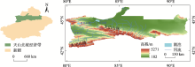
图1
研究区位置与地形水系图 注:底图采用自然资源部标准地图制作,审图号为GS(2023)2767号,对底图边界无修改。下同。"


图2
1961—2018年天山北坡经济带NR变化特征 注:图c、d、e、f中显著性水平均为0.05;NR为天然径流量,下同。"

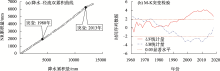
图3
天山北坡经济带NR突变检验"

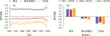
图4
NR对降水、潜在蒸散发和下垫面的弹性系数年际变化"

表1
天山北坡经济带NR变化归因分析"
| 参数 | ||||||
|---|---|---|---|---|---|---|
| 第一个变化期(1980—2012年) | 22.20 | -0.10 | 10.27 | 68.2 | 0.3 | 31.5 |
| 第二个变化期(2013—2018年) | 42.21 | -1.84 | -36.82 | 52.2 | 2.3 | 45.5 |
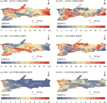
图5
NR变化贡献率的空间分布"

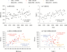
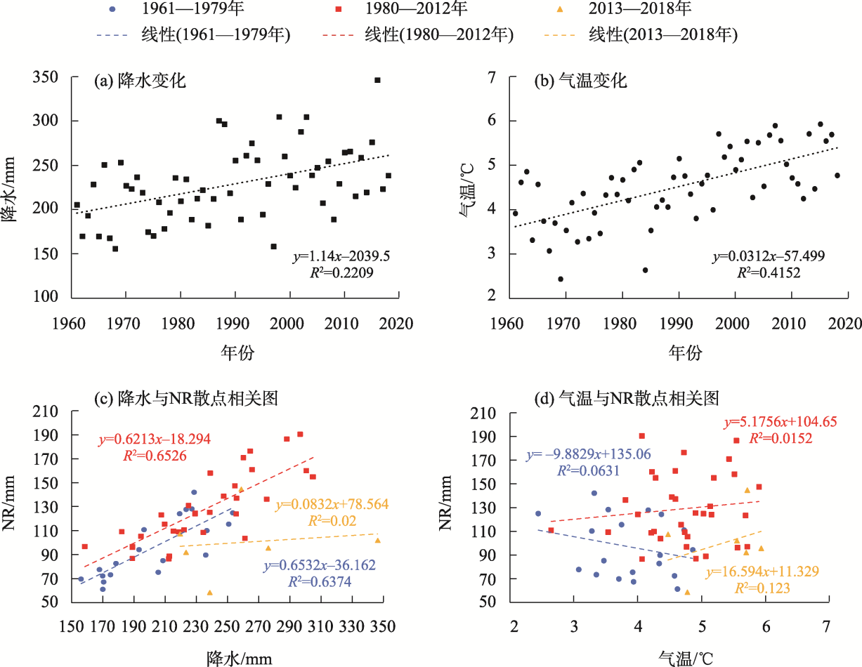
图6
天山北坡经济带降水、气温特征"
| [1] | Dey P, Mishra A. Separating the impacts of climate change and human activities on streamflow: A review of methodologies and critical assumptions[J]. Journal of Hydrology, 2017, 548: 278-290. |
| [2] |
梁双河, 牛最荣, 贾玲. 祖厉河干流近65 a径流变化及归因分析[J]. 干旱区研究, 2024, 41(6): 928-939.
doi: 10.13866/j.azr.2024.06.03 |
|
[Liang Shuanghe, Niu Zuirong, Jia Ling. Analysis of runoff changes and attribution in the main stream of Zuli River in the past 65 years[J]. Arid Zone Research, 2024, 41(6): 928-939.]
doi: 10.13866/j.azr.2024.06.03 |
|
| [3] |
段雨佳, 何毅, 赵杰, 等. 人类活动对秦岭月河流域径流变化的影响分析[J]. 干旱区研究, 2023, 40(4): 605-614.
doi: 10.13866/j.azr.2023.04.09 |
|
[Duan Yujia, He Yi, Zhao Jie, et al. Analysis of impact of human activities on runoff changes in Yue River Basin of the Qinling Mountains[J]. Arid Zone Research, 2023, 40(4): 605-614.]
doi: 10.13866/j.azr.2023.04.09 |
|
| [4] |
胡广录, 陶虎, 焦娇, 等. 黑河中游正义峡径流变化趋势及归因分析[J]. 干旱区研究, 2023, 40(9): 1414-1424.
doi: 10.13866/j.azr.2023.09.05 |
|
[Hu Guanglu, Tao Hu, Jiao Jiao, et al. Runoff trend and attribution analysis of the Zhengyi Gorge in the middle reaches of the Heihe River[J]. Arid Zone Research, 2023, 40(9): 1414-1424.]
doi: 10.13866/j.azr.2023.09.05 |
|
| [5] | 江善虎, 刘亚婷, 任立良, 等. 变化环境下渭河流域生态水文情势演变归因研究[J]. 水资源保护, 2022, 38(6): 9-14, 70. |
| [Jiang Shanhu, Liu Yating, Ren Liliang, et al. Attribution analysis of eco-hydrological regime evolution in the Weihe River Basin under changing environment[J]. Water Resources Protection, 2022, 38(6): 9-14, 70.] | |
| [6] |
陈亚宁, 李玉朋, 李稚, 等. 全球气候变化对干旱区影响分析[J]. 地球科学进展, 2022, 37(2): 111-119.
doi: 10.11867/j.issn.1001-8166.2022.006 |
|
[Chen Yaning, Li Yupeng, Li Zhi, et al. Analysis of the impact of global climate change on dryland areas[J]. Advances in Earth Science, 2022, 37(2): 111-119.]
doi: 10.11867/j.issn.1001-8166.2022.006 |
|
| [7] | 朱慧, 王哲, 焦光辉, 等. 天山北坡经济带经济格局时空演变特征研究[J]. 干旱区资源与环境, 2012, 26(3): 23-29. |
| [Zhu Hui, Wang Zhe, Jiao Guanghui, et al. Spatial dynamic evolution of economic pattern in economic belt on the north slope of Tianshan[J]. Journal of Arid Land Resources and Environment, 2012, 26(3): 23-29.] | |
| [8] | 凌敏华, 陈万贺. 地下水资源对新疆经济社会支撑作用的定量评价[J]. 水资源保护, 2021, 37(2): 49-54, 62. |
| [Ling Minhua, Chen Wanhe. Quantitative evaluation of groundwater resources supporting economy and society in Xinjiang[J]. Water Resources Protection, 2021, 37(2): 49-54, 62.] | |
| [9] | 陈伏龙, 王怡璇, 吴泽斌, 等. 气候变化和人类活动对干旱区内陆河径流量的影响——以新疆玛纳斯河流域肯斯瓦特水文站为例[J]. 干旱区研究, 2015, 32(4): 692-697. |
| [Chen Fulong, Wang Yixuan, Wu Zebin, et al. Impacts of climate change and human activities on runoff of continental river in arid areas: Taking Kensiwate Hydrological Station in Xinjiang Manas River Basin as an example[J]. Arid Zone Research, 2015, 32(4): 692-697.] | |
| [10] | 魏天锋, 刘志辉, 姚俊强, 等. 呼图壁河径流过程对气候变化的响应[J]. 干旱区资源与环境, 2015, 29(4): 102-107. |
| [Wei Tianfeng, Liu Zhihui, Yao Junqiang, et al. Response of Hutubi River runoff process on climate change[J]. Journal of Arid Land Resources and Environment, 2015, 29(4): 102-107.] | |
| [11] |
王荣军, 刘时银, 王睿, 等. 天山北坡降雨补给型河流径流变化特征及其影响因子分析[J]. 冰川冻土, 2016, 38(5): 1353-1361.
doi: 10.7522/j.issn.1000-0240.2016.0159 |
|
[Wang Rongjun, Liu Shiyin, Wang Rui, et al. Analysis of a river fed by precipitation in north slopes of the Tianshan Mountains: Runoff characteristics and influence factors[J]. Journal of Glaciology and Geocryology, 2016, 38(5): 1353-1361.]
doi: 10.7522/j.issn.1000-0240.2016.0159 |
|
| [12] |
陈红光, 孟凡浩, 萨楚拉, 等. 北方牧区草原内陆河流域径流演变特征及其驱动因素分析[J]. 干旱区研究, 2023, 40(1): 39-50.
doi: 10.13866/j.azr.2023.01.05 |
|
[Chen Hongguang, Meng Fanhao, Sa Chula, et al. Analysis of the characteristics of runoff evolution and its driving factors in a typical inland river basin in arid regions[J]. Arid Zone Research, 2023, 40(1): 39-50.]
doi: 10.13866/j.azr.2023.01.05 |
|
| [13] | Chen Z S, Chen Y N, Li B F. Quantifying the effects of climate variability and human activities on runoff for Kaidu River Basin in arid region of northwest China[J]. Theoretical and Applied Climatology, 2013, 111(3-4): 537-545. |
| [14] | 刘思海, 侍克斌, 张宏科, 等. 近60年渭干河上游克孜尔水库水沙变化趋势及其影响因素分析[J]. 干旱区资源与环境, 2018, 32(8): 153-160. |
| [Liu Sihai, Shi Kebin, Zhang Hongke, et al. The variation trend of streamflow and sediment flux in the upper reaches of Weigan river over the past 60 years[J]. Journal of Arid Land Resources and Environment, 2018, 32(8): 153-160.] | |
| [15] | 王金凤. 气候变化和人类活动影响下的北大河流域径流变化分析[J]. 干旱区资源与环境, 2019, 33(3): 86-91. |
| [Wang Jinfeng. Analysis on runoff variation in the Beida River Basin under the influence of climate change and human activities[J]. Journal of Arid Land Resources and Environment, 2019, 33(3): 86-91.] | |
| [16] | 张艳霞, 于瑞宏, 薛浩, 等. 锡林河流域径流量变化对气候变化与人类活动的响应[J]. 干旱区研究, 2019, 36(1): 67-76. |
| [Zhang Yanxia, Yu Ruihong, Xue Hao, et al. Response of runoff volume change to climate change and human activities in the Xilin River Basin[J]. Arid Zone Research, 2019, 36(1): 67-76.] | |
| [17] | 张丽梅, 赵广举, 穆兴民, 等. 基于Budyko假设的渭河径流变化归因识别[J]. 生态学报, 2018, 38(21): 7607-7617. |
| [Zhang Limei, Zhao Guangju, Mu Xingmin, et al. Attribution of runoff variation in the Wei River Basin based on the Budyko hypothesis[J]. Acta Ecologica Sinica, 2018, 38(21): 7607-7617.] | |
| [18] | 穆兴民, 李靖, 王飞, 等. 黄河天然径流量年际变化过程分析[J]. 干旱区资源与环境, 2003, 17(2): 1-5. |
| [Mu Xingmin, Li Jing, Wang Fei, et al. Analysis on the annual natural runoff variety process of the Yellow River[J]. Journal of Arid Land Resources and Environment, 2003, 17(2): 1-5.] | |
| [19] | 王楠, 李明蔚, 陈首志, 等. 基于堆叠机器学习的非充分数据条件下流域径流还原方法研究: 以沮漳河为例[J/OL]. 水利水电技术(中英文), 2024: 1-14. [2024-07-01]. https://link.cnki.net/urlid/10.1746.TV.20240701.1207.005. |
| [Wang Nan, Li Mingwei, Chen Shouzhi, et al. A watershed runoff reconstruction method based on stacked ensemble machine learning under incomplete data: A case study of Juzhanghe River[J/OL]. Water Resources and Hydropower Engineering, 2024: 1-14. [2024-07-01]. https://link.cnki.net/urlid/10.1746.TV.20240701.1207.005.] | |
| [20] | 李焯, 任凤仪, 李晓, 等. 黄河流域天然径流量还原及一致性处理方法研究[J]. 人民黄河, 2023, 45(12): 37-40, 134. |
| [Li Zhuo, Ren Fengyi, Li Xiao, et al. Study on natural runoff reduction and consistency treatment methods in the Yellow River Basin[J]. Yellow River, 2023, 45(12): 37-40, 134.] | |
| [21] | 郝鑫怡, 张喆, 郑浩, 等. 天山北坡经济带植被覆盖度时空变化特征及影响因素探测[J/OL]. 中国环境科学, 2023: 1-12. [2023-10-12]. https://doi.org/10.19674/j.cnki.issn1000-6923.20230926.002. |
| [Hao Xinyi, Zhang Zhe, Zheng Hao, et al. Detection of spatial and temporal variation characteristics of vegetation cover in the economic zone of the northern slopes of Tianshan Mountains and the influencing factors[J/OL]. China Environmental Science, 2023: 1-12. [2023-10-12]. https://doi.org/10.19674/j.cnki.issn1000-6923.20230926.002.] | |
| [22] | 方创琳, 高倩, 张小雷, 等. 城市群扩展的时空演化特征及对生态环境的影响——以天山北坡城市群为例[J]. 中国科学: 地球科学, 2019, 49(9): 1413-1424. |
| [Fang Chuanglin, Gao Qian, Zhang Xiaolei, et al. Spatiotemporal characteristics of the expansion of an urban agglomeration and its effect on the eco-environment: Case study on the northern slope of the Tianshan Mountains[J]. Science China Earth Sciences, 2019, 49(9): 1413-1424.] | |
| [23] | Jiang W G, Yuan L H, Wang W J, et al. Spatio-temporal analysis of vegetation variation in the Yellow River Basin[J]. Ecological Indicators, 2015, 51: 117-126. |
| [24] | Fu J Y, Liu B J, Wang W G, et al. Evaluating main drivers of runoff changes across China from 1956 to 2000 by using different Budyko-based elasticity methods[J]. Journal of Environmental Management, 2023, 329: 117070. |
| [25] | Yang H B, Yang D W, Lei Z D. New analytical derivation of the mean annual water-energy balance equation[J]. Water Resources Research, 2008, 44(3): W03410. |
| [26] | Choudhury B J. Evaluation of an empirical equation for annual evaporation using field observations and results from a biophysical model[J]. Journal of Hydrology, 1999, 216(1-2): 99-110. |
| [27] | Xu X Y, Yang D W, Yang H B, et al. Attribution analysis based on the Budyko hypothesis for detecting the dominant cause of runoff decline in Haihe basin[J]. Journal of Hydrology, 2014, 510: 530-540. |
| [28] | Yang H B, Yang D W. Derivation of climate elasticity of runoff to assess the effects of climate change on annual runoff[J]. Water Resources Research, 2011, 47: W07526. |
| [29] | 穆兴民, 张秀勤, 高鹏, 等. 双累积曲线方法理论及在水文气象领域应用中应注意的问题[J]. 水文, 2010, 30(4): 47-51. |
| [Mu Xingmin, Zhang Xiuqin, Gao Peng, et al. Theory of double mass curves and its applications in hydrology and meteorology[J]. Journal of China Hydrology, 2010, 30(4): 47-51.] | |
| [30] | 郭爱军, 畅建霞, 王义民, 等. 近50年泾河流域降雨-径流关系变化及驱动因素定量分析[J]. 农业工程学报, 2015, 31(14): 165-171. |
| [Guo Aijun, Chang Jianxia, Wang Yimin, et al. Variation characteristics of rainfall-runoff relationship and driving factors analysis in Jinghe River Basin in nearly 50 years[J]. Transactions of the Chinese Society of Agricultural Engineering, 2015, 31(14): 165-171.] | |
| [31] | 贺晋云, 张明军, 王鹏, 等. 新疆气候变化研究进展[J]. 干旱区研究, 2011, 28(3): 499-508. |
| [He Jinyun, Zhang Mingjun, Wang Peng, et al. New progress of the study on climate change in Xinjiang[J]. Arid Zone Research, 2011, 28(3): 499-508.] | |
| [32] | 刘爽爽, 李忠勤, 张慧, 等. 天山典型冰川区径流年内变化分析[J]. 干旱区研究, 2020, 37(6): 1388-1395. |
| [Liu Shuangshuang, Li Zhongqin, Zhang Hui, et al. Temporal inner-annual runoff variation in the variation in the typical glacier region of the eastern Tianshan Mountains, China[J]. Arid Zone Research, 2020, 37(6): 1388-1395.] | |
| [33] | Thompson J R. Modelling the impacts of climate change on upland catchments in southwest Scotland using MIKE SHE and the UKCP09 probabilistic projections[J]. Hydrology Research, 2012, 43(4): 507-530. |
| [34] | 左其亭, 李佳伟, 马军霞, 等. 新疆水资源时空变化特征及适应性利用战略研究[J]. 水资源保护, 2021, 37(2): 21-27. |
| [Zuo Qiting, Li Jiawei, Ma Junxia, et al. Study on spatio-temporal variation characteristics and adaptive utilization strategy of water resources in Xinjiang[J]. Water Resources Protection, 2021, 37(2): 21-27.] | |
| [35] | 魏潇娜, 龙爱华, 尹振良, 等. 和田河流域冰川径流对气候变化响应的模拟分析[J]. 水资源保护, 2022, 38(4): 137-144. |
| [Wei Xiaona, Long Aihua, Yin Zhenliang, et al. Simulation of response of glacier runoff to climate change in the Hotan River Basin[J]. Water Resources Protection, 2022, 38(4): 137-144.] | |
| [36] | 田鹏, 穆兴民, 赵广举, 等. 近549年来黄河天然径流量时间变化特征研究[J]. 水土保持学报, 2020, 34(6): 65-69. |
| [Tian Peng, Mu Xingmin, Zhao Guangju, et al. Variations of natural runoff in the Yellow River since 1470[J]. Journal of Soil and Water Conservation, 2020, 34(6): 65-69.] |
| [1] | 陆文静, 瞿德业, 杨明月, 黄翰林, 杨山泉. 基于GCM的蒙古高原降水稳定同位素模拟[J]. 干旱区研究, 2024, 41(9): 1491-1502. |
| [2] | 袁征, 张志高, 闫瑾, 刘嘉毅, 胡柱钰, 王赟, 蔡茂堂. 1960—2020年黄河流域不同等级降水时空特征[J]. 干旱区研究, 2024, 41(8): 1259-1271. |
| [3] | 李超, 隆霄, 曹怡清, 韩子霏, 王号, 郑景元. 不同风场结构下贺兰山地形降水的理想数值试验[J]. 干旱区研究, 2024, 41(8): 1272-1287. |
| [4] | 王岱, 李欣, 张雯, 马阳, 王素艳, 李佳瑶. 海温与海冰对宁夏汛期降水分布特征异常的协同影响[J]. 干旱区研究, 2024, 41(8): 1288-1299. |
| [5] | 史天艺, 张萌萌, 蒲阳, 刘硕元. 毛乌素沙地植被NDVI动态及对降水的多时空响应[J]. 干旱区研究, 2024, 41(8): 1395-1404. |
| [6] | 李烨, 江伟, 陈晓俊, 吴英杰, 王思楠. 基于降水量距平百分率的1961—2020年鄂尔多斯气象干旱趋势[J]. 干旱区研究, 2024, 41(7): 1099-1111. |
| [7] | 山建安, 朱睿, 尹振良, 杨华庆, 张薇, 方春爽. 基于CMIP6模式的中国西北地区干旱时空变化[J]. 干旱区研究, 2024, 41(5): 717-729. |
| [8] | 杨霞, 江远安, 张林梅, 李朋伦, 肖俊安. 哈密市伊吾县峡沟水库集水区汛期降水特征[J]. 干旱区研究, 2024, 41(5): 753-764. |
| [9] | 许超杰, 窦燕, 孟琪琳. 基于EMD-GWO-LSTM模型的新疆标准化降水蒸散指数预测方法研究[J]. 干旱区研究, 2024, 41(4): 527-539. |
| [10] | 尹瑞琪, 李琼芳, 陈启慧, 张静芳, 张炜, 林雍权, 方凯悦. 伊犁河上游流域三种日尺度降水产品性能评估[J]. 干旱区研究, 2024, 41(4): 540-549. |
| [11] | 李晗薇, 姚俊强, 容韬, 张天洋, 高雅洁. 塔什库尔干河流域河谷大气降水同位素特征与水汽输送路径[J]. 干旱区研究, 2024, 41(3): 399-410. |
| [12] | 杨雅青, 张翀, 张婕, 王玉丹. 关中地区土壤干湿变化及对气候的响应[J]. 干旱区研究, 2024, 41(2): 261-271. |
| [13] | 杨秀梅, 孔祥伟, 沙宏娥, 张君霞. 两种中尺度模式对甘肃河东暴雨日降水预报偏差精细化评估[J]. 干旱区研究, 2024, 41(12): 1992-2003. |
| [14] | 杨斐, 张文韬, 张飞民, 王澄海. 1961—2022年祁连山气候特征及其变化[J]. 干旱区研究, 2024, 41(10): 1627-1638. |
| [15] | 沙涛, 张玲卫, 刘会良, 张岚, 卢妤婷, 周鑫宇, 文晓虎, 张元明. 降水、氮沉降对尖喙牻牛儿苗隔代生理可塑性的影响[J]. 干旱区研究, 2024, 41(10): 1753-1766. |
|
||