干旱区研究 ›› 2024, Vol. 41 ›› Issue (6): 1010-1020.doi: 10.13866/j.azr.2024.06.10 cstr: 32277.14.AZR.20240610
杨荣钦1,2( ), 肖玉磊3, 池苗苗3, 穆振侠1,2()
收稿日期:2023-11-21
修回日期:2024-03-03
出版日期:2024-06-15
发布日期:2024-07-03
作者简介:杨荣钦(1999-),男,硕士研究生,主要从事水文水资源研究. E-mail: 320222290@xjau.edu.cn
基金资助:
YANG Rongqin1,2(), XIAO Yulei3, CHI Miaomiao3, MU Zhenxia1,2()
Received:2023-11-21
Revised:2024-03-03
Published:2024-06-15
Online:2024-07-03
摘要:
人类活动是区域生态风险加剧的重要因素,亟需探讨人类活动强度对景观生态风险影响。本文以塔里木河流域为研究对象,基于近20 a的5期土地利用、人口空间分布和夜间灯光数据,引入土地利用程度综合指数以改进人类活动强度(HAI)评价体系,定量评价强人类活动下的流域景观生态风险(LER)时空变化,并结合Copula函数以及双变量局部空间自相关模型,揭示LER与HAI的时空关联性。结果表明:(1) 近20 a塔里木河流域HAI显著提高,强人类活动主要分布于水资源较丰富的绿洲区;流域人类活动强度呈增加趋势,低强度区面积占比减少17.88%、中高强度区面积占比增加3.57%。(2) 塔里木河流域LER整体呈四周高、中部低的特征,高风险区主要分布于人类活动较为频繁的绿洲区;流域LER在2015年前呈加剧趋势,但2010年后加剧趋势减缓,2015年后改善趋势逐步显现。(3) 近20 a HAI与LER呈正相关关系,人类活动对LER的正向效应不断增加;2010年后二者关系的增加趋势趋于平缓,正向效应出现由增到减的过渡阶段;空间上H-H聚集区呈增加趋势,分布格局由分散变为集中;2015年后,L-L和H-L聚集区缓慢增加,L-H聚集区缓慢减少。研究结果可为塔里木河流域土地资源合理利用、景观生态保护提供科学参考。
杨荣钦, 肖玉磊, 池苗苗, 穆振侠. 近20 a塔里木河流域人类活动及景观生态风险时空变化[J]. 干旱区研究, 2024, 41(6): 1010-1020.
YANG Rongqin, XIAO Yulei, CHI Miaomiao, MU Zhenxia. Temporal and spatial variations of human activities and landscape ecological risks in the Tarim River Basin, China, during the last 20 years[J]. Arid Zone Research, 2024, 41(6): 1010-1020.
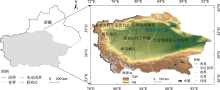
图1
研究区概况 注:底图采用自然资源部标准地图制作,审图号为GS(2023)2767号,对底图边界无修改。下同。"

表1
塔里木河流域2000—2020年土地利用类型转移矩阵"
| 2000年 | 2020年 | ||||||
|---|---|---|---|---|---|---|---|
| 耕地 | 林地 | 草地 | 水域 | 建设用地 | 未利用土地 | 总计 | |
| 耕地 | - | 1098.66 | 1425.45 | 203.65 | 1297.06 | 542.65 | 4567.47 |
| 林地 | 2071.37 | - | 5722.53 | 272.24 | 76.65 | 1808.06 | 9950.85 |
| 草地 | 12165.10 | 6037.15 | - | 3734.20 | 289.33 | 86713.10 | 108938.87 |
| 水域 | 490.03 | 231.77 | 7353.46 | - | 71.48 | 15430.09 | 23576.83 |
| 建设用地 | 822.63 | 85.20 | 68.18 | 8.33 | - | 36.20 | 1020.54 |
| 未利用土地 | 4680.59 | 1418.17 | 84866.90 | 5705.87 | 845.78 | - | 97517.29 |
| 总计 | 20229.72 | 8870.95 | 99436.50 | 9924.28 | 2580.30 | 104530.09 | 245571.85 |
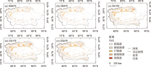
图2
人类活动强度空间变化特征"

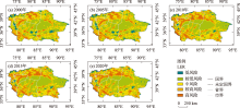
图3
景观生态风险空间变化特征"

表2
各年平均ERI和LER等级面积占比"
| 年份 | 平均 ERI | LER各等级面积占比/% | ||||
|---|---|---|---|---|---|---|
| 低风险 | 较低风险 | 中风险 | 较高风险 | 高风险 | ||
| 2000年 | 0.075 | 5.79 | 39.25 | 31.64 | 17.37 | 5.94 |
| 2005年 | 0.075 | 5.86 | 39.09 | 31.19 | 17.84 | 6.03 |
| 2010年 | 0.077 | 3.95 | 38.51 | 27.48 | 19.78 | 10.28 |
| 2015年 | 0.078 | 3.93 | 37.98 | 26.72 | 20.24 | 11.14 |
| 2020年 | 0.078 | 3.91 | 38.42 | 27.49 | 20.15 | 10.03 |
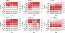
图4
不同土地利用类型景观生态风险等级占比"

表3
各Copula函数平方欧式距离"
| 函数类型 | 2000年 | 2005年 | 2010年 | 2015年 | 2020年 |
|---|---|---|---|---|---|
| Frank Copula | 9.50 | 27.57 | 26.66 | 22.60 | 23.18 |
| Clayton Copula | 17.34 | 36.57 | 28.92 | 24.75 | 24.87 |
| Gumbel Copula | 14.22 | 37.62 | 51.95 | 45.32 | 45.71 |
| t Copula | 10.22 | 29.71 | 31.04 | 26.67 | 27.25 |
| Gaussian Copula | 13.18 | 37.38 | 48.84 | 41.18 | 40.82 |
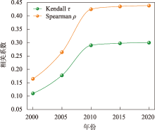
图5
HAI和LER时间关联特征"

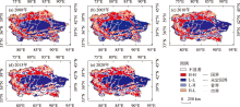
图6
HAI和LER空间关联特征 注:H-H表示HAI高和LER高;L-L表示HAI低和LER低;L-H表示HAI低和LER高;H-L表示HAI高和LER低。"

| [1] | 曹顺爱, 吴次芳, 余万军. 土地生态服务价值评价及其在土地利用布局中的应用——以杭州市萧山区为例[J]. 水土保持学报, 2006, 20(2): 197-200. |
| [Cao Shunai, Wu Cifang, Yu Wanjun. Evaluation of land ecological service and its application in overall arrangement of land use: A case study of Xiaoshan, Hangzhou[J]. Journal of Soil and Water Conservation, 2006, 20(2): 197-200. ] | |
| [2] | Mikša K, Kalinauskas M, Inácio M, et al. Ecosystem services and legal protection of private property. Problem or solution?[J]. Geography and Sustainability, 2020, 1(3): 173-180. |
| [3] | Burkhard B, Kroll F, Nedkov S, et al. Mapping ecosystem service supply, demand and budgets[J]. Ecological Indicators, 2012, 21: 17-29. |
| [4] | 刘坤, 于赐刚, 张艺凡, 等. 青藏高原自然保护区人类活动及其影响研究现状与热点[J]. 应用与环境生物学报, 2022, 28(2): 508-516. |
| [Liu Kun, Yu Cigang, Zhang Yifan, et al. Research status and current hotspots on the human impact on natural reserves in the Qinghai-Tibetan Plateau[J]. Chinese Journal of Applied and Environmental, 2022, 28(2): 508-516. ] | |
| [5] | Norton S, Rodier D, Van Der Schalie W H, et al. A framework for ecological risk assessment at the EPA[J]. Environmental Toxicology and Chemistry, 1992, 11(12): 1663-1672. |
| [6] |
彭建, 党威雄, 刘焱序, 等. 景观生态风险评价研究进展与展望[J]. 地理学报, 2015, 70(4): 664-677.
doi: 10.11821/dlxb201504013 |
|
[Peng Jian, Dang Weixiong, Liu Yanxu, et al. Review on landscape ecological risk assessment[J]. Acta Geographica Sinica, 2015, 70(4): 664-677. ]
doi: 10.11821/dlxb201504013 |
|
| [7] |
徐丽芬, 许学工, 卢亚灵, 等. 基于自然灾害的北京幅综合生态风险评价[J]. 生态环境学报, 2010, 19(11): 2607-2612.
doi: 10.16258/j.cnki.1674-5906(2010)11-2607-06 |
| [Xu Lifen, Xu Xuegong, Lu Yaling, et al. Integrated ecological risk assessment of J-50 based on natural disasters risk source[J]. Ecology and Environmental Sciences, 2010, 19(11): 2607-2612. ] | |
| [8] | Hou M, Ge J, Gao J, et al. Ecological risk assessment and impact factor analysis of alpine wetland ecosystem based on LUCC and boosted regression tree on the Zoige Plateau, China[J]. Remote Sensing, 2020, 12(3): 1-22. |
| [9] | Leuven R, Isabelle D. Riverine landscape dynamics and ecological risk assessment[J]. Freshwater Biology, 2002, 47(4): 845-865. |
| [10] | Ai J, Yu K, Zhen Z, et al. Assessing the dynamic landscape ecological risk and its driving forces in an island city based on optimal spatial scales: Haitan Island, China[J]. Ecological Indicators, 2022, 137: 108771. |
| [11] | Liu J, Wang M, Yang L. Assessing landscape ecological risk induced by land-use/cover change in a county in China: A GIS- and landscape-metric-mased approach[J]. Sustainability, 2020, 12(21): 9037. |
| [12] | 方林, 方斌, 刘艳晓, 等. 长三角地区景观生态风险与人类活动强度的响应及其时空关联[J]. 农业工程学报, 2022, 38(22): 210-219. |
| [Fang Lin, Fang Bin, Liu Yanxiao, et al. Scale response and spatiotemporal correlations between landscape ecological risk and human activity intensity in the Yangtze River Delta region[J]. Transactions of the Chinese Society of Agricultural Engineering (Transactions of the CSAE), 2022, 38(22): 210-219. ] | |
| [13] | 邓铭江. 干旱内陆河流域河湖生态环境复苏关键技术[J]. 中国水利, 2022, 73(7): 21-27. |
| [Deng Mingjiang. Key technologies of rivers and lakes eco-environment recovery in arid inland river basin[J]. China Water Resources, 2022, 73(7): 21-27. ] | |
| [14] | 彭茹燕, 刘连友, 张宏. 人类活动对干旱区内陆河流域景观格局的影响分析——以新疆和田河中游地区为例[J]. 自然资源学报, 2003, 18(4): 492-498. |
| [Peng Ruyan, Liu Lianyou, Zhang Hong. Analysis of the impacts of human activities on landscape patterns in inland river basin of arid zone: Taking the middle reaches of Hetian River as an example[J]. Journal of Natural Resources, 2003, 18(4): 492-498. ] | |
| [15] | 刘新华, 徐海量, 凌红波, 等. 塔里木河干流河道生态需水量研究[J]. 干旱区研究, 2012, 29(6): 984-991. |
| [Liu Xinhua, Xu Hailiang, Ling Hongbo, et al. Study on ecological water requirements along the mainstream channel of the Tarim River[J]. Arid Zone Research, 2012, 29(6): 984-991. ] | |
| [16] | Ling H, Yan J, Guo B, et al. Evaluation of water and land exploitation based on the ecosystem service value in a hyper-arid region with intensifying basin management[J]. Land Degradation & Development, 2019, 30(18): 2165-2176. |
| [17] | 邓铭江, 周海鹰, 徐海量, 等. 塔里木河干流上中游丰枯情景下生态水调控研究[J]. 干旱区研究, 2017, 34(5): 959-966. |
| [Deng Mingjiang, Zhou Haiying, Xu Hailiang, et al. Regulation of ecological water volume under high-or low-flow in the mainstream area of the Tarim River[J]. Arid Zone Research, 2017, 34(5): 959-966. ] | |
| [18] | 杜慧娟, 王光耀, 冉光妍, 等. 面向SDGs的塔里木河流域农业灰水足迹分析[J]. 干旱区研究, 2023, 40(7): 1184-1193. |
| [Du Huijuan, Wang Guangyao, Ran Guangyan, et al. Agricultural gray water footprint in the Tarim River Basin using SDGs analysise[J]. Arid Zone Research, 2023, 40(7): 1184-1193. ] | |
| [19] | 邓铭江, 樊自立, 徐海量, 等. 塔里木河流域生态功能区划研究[J]. 干旱区地理, 2017, 40(4): 705-717. |
| [Deng Mingjiang, Fan Zili, Xu Hailiang, et al. Ecological function regionalization of Tarim River Basin[J]. Arid Land Geography, 2017, 40(4): 705-717. ] | |
| [20] |
陈泓瑾, 刘琳, 张正勇, 等. 天山北坡人类活动强度与地表温度的时空关联性[J]. 地理学报, 2022, 77(5): 1244-1259.
doi: 10.11821/dlxb202205014 |
|
[Chen Hongjin, Liu Lin, Zhang Zhengyong, et al. Spatiotemporal correlation between human activity intensity and surface temperature on the north slope of Tianshan Mountains[J]. Acta Geographica Sinica, 2022, 77(5): 1244-1259. ]
doi: 10.11821/dlxb202205014 |
|
| [21] | 庄大方, 刘纪远. 中国土地利用程度的区域分异模型研究[J]. 自然资源学报, 1997, 12(2): 10-16. |
| [Zhuang Dafang, Liu Jiyuan. Study on the model of regional differentiation of land use degree in China[J]. Journal of Natural Resources, 1997, 12(2): 10-16. ] | |
| [22] | Lan Y, Chen J, Yang Y, et al. Landscape pattern and ecological risk assessment in Guilin Based on land use change[J]. International Journal of Environmental Research and Public Health, 2023, 20(3): 2045. |
| [23] |
张学斌, 石培基, 罗君, 等. 基于景观格局的干旱内陆河流域生态风险分析——以石羊河流域为例[J]. 自然资源学报, 2014, 29(3): 410-419.
doi: 10.11849/zrzyxb.2014.03.005 |
|
[Zhang Xuebin, Shi Peiji, Luo Jun, et al. The ecological risk assessment of arid inland river basin at the landscape scale:A case study on Shiyang River Basin[J]. Journal of Natural Resources, 2014, 29(3): 410-419. ]
doi: 10.11849/zrzyxb.2014.03.005 |
|
| [24] | 朱瑞广, 吕大刚. 基于Copula函数的主余震地震动强度参数相关性分析[J]. 工程力学, 2019, 36(2): 114-123. |
| [Zhu Ruiguang, Lv Dagang. Copula-based correlation analysis of intensity measures of mainshock-aftershock ground motions[J]. Engineering Mechanics, 2019, 36(2): 114-123. ] | |
| [25] | 张龄月. 一类有关随机向量间非线性相依度量的研究及其应用[D]. 大连: 大连理工大学, 2022. |
| [Zhang Lingyue. The Measures of Nonlinear Dependence for Random Vectors and Their Application[D]. Dalian: Dalian University of Technology, 2022. ] | |
| [26] |
郑德凤, 郝帅, 吕乐婷, 等. 三江源国家公园生态系统服务时空变化及权衡-协同关系[J]. 地理研究, 2020, 39(1): 64-78.
doi: 10.11821/dlyj020180898 |
|
[Zheng Defeng, Hao Shuai, Lv Leting, et al. Spatial-temporal change and trade-off/synergy relationships among multiple ecosystem services in Three-River-Source National Park[J]. Geographical Research, 2020, 39(1): 64-78. ]
doi: 10.11821/dlyj020180898 |
|
| [27] | 钟绍卓, 孙浩源. 不同情景下祁连山国家级自然保护区生态系统服务时空变化及权衡与协同关系[J]. 水土保持研究, 2023, 30(5): 358-369. |
| [Zhong Shaozhuo, Sun Haoyuan. Assessment on spatiotemporal variation and synergies/tradeoffs relationships of ecosystem services in Qilian Mountain National Nature Reserve under different scenarios[J]. Research of Soil and Water Conservation, 2023, 30(5): 358-369. ] | |
| [28] | Cao S, Chen L, Shankman D, et al. Excessive reliance on afforestation in China’s arid and semi-arid regions: Lessons in ecological restoration[J]. Earth-Science Reviews, 2011, 104(4): 240-245. |
| [29] | Thornbrugh D, Infante D, Tsang Y. Regional trends of biodiversity indices in the temperate mesic United States: Testing for influences of anthropogenic land use on stream fish while controlling for natural landscape variables[J]. Water, 2023, 15(8): 1591. |
| [30] | Niki R, Erik L O, Sara I, et al. Perceived causes and solutions to soil degradation in the UK and Norway[J]. Land, 2022, 11(1): 131. |
| [31] | 李路, 孙桂丽, 陆海燕, 等. 喀什绿洲土地利用空间格局变化特征分析[J]. 西南大学学报(自然科学版), 2020, 42(5): 141-150. |
| [Li Lu, Sun Guili, Lu Haiyan, et al. Analysis of dynamic change characteristics of land use spatial pattern in Kashgar Oasis[J]. Journal of Southwest University(Natural Science Edition), 2020, 42(5): 141-150. ] | |
| [32] | 师君银, 马勇刚, 许仲林. 喀什地区土地利用变化对生境质量的影响[J]. 西南农业学报, 2023, 36(11): 2480-2490. |
| [Shi Junyin, Ma Yonggang, Xu Zonglin. Impact of land use changes on habitat quality in Kashgar region[J]. Southwest China Journal of Agricultural Sciences, 2023, 36(11): 2480-2490. ] | |
| [33] | 王文杰, 张永福, 王慧杰. 基于GIS干旱区绿洲县域土地利用变化生态风险分析——以新疆泽普县为例[J]. 水土保持研究, 2016, 23(6): 216-220, 2. |
| [Wang Wenjie, Zhang Yongfu, Wang Huijie. Analysis on ecological risk of land use at county level in the arid oasis base on GIS—A case study in Zepu of Xinjiang[J]. Research of Soil and Water Conservation, 2016, 23(6): 216-220, 2. ] | |
| [34] | 朱会义, 李秀彬. 关于区域土地利用变化指数模型方法的讨论[J]. 地理学报, 2003, 58(5): 643-650. |
|
[Zhu Huiyi, Li Xiubin. Discussion on the index method of regional land use change[J]. Acta Geographica Sinica, 2003, 58(5): 643-650. ]
doi: 10.11821/xb200305001 |
|
| [35] | 王鹏, 秦思彤, 胡慧蓉. 近30 a拉萨河流域土地利用变化和生境质量的时空演变特征[J]. 干旱区研究, 2023, 40(3): 492-503. |
| [Wang Peng, Qin Sitong, Hu Huirong. Spatial-temporal evolution characteristics of land use change and habitat quality in the Lhasa River Basin over the past three decades[J]. Arid Zone Research, 2023, 40(3): 492-503. ] | |
| [36] | 赵新风, 徐海量, 张鹏, 等. 塔里木河下游地区不同滴灌频率下沙枣防护林成活率与生长量特征[J]. 林业科学, 2012, 48(10): 150-156. |
| [Zhao Xinfeng, Xu Hailiang, Zhang Peng, et al. Survival rate and growth characteristics of Elaeagnus angustifolia shelterbelts under the different drip irrigation frequency in the lower reaches of Tarim River[J]. Scientia Silvae Sinicae, 2012, 48(10): 150-156. ] | |
| [37] | 邓晓雅, 龙爱华, 高海峰, 等. 塔里木河流域绿色生态空间与景观格局变化研究[J]. 中国水利水电科学研究院学报, 2020, 18(5): 369-376. |
| [Deng Xiaoya, Long Aihua, Gao Haifeng, et al. Processes shaping land cover and green space changes in the Tarim River Basin[J]. Journal of China Institute of Water Resources and Hydropower Research, 2020, 18(5): 369-376. ] | |
| [38] | 魏靖阳, 於冉, 付丹阳, 等. 成渝城市群景观生态风险与人类活动强度时空关联分析[J]. 安徽农业大学学报, 2023, 50(5): 887-896. |
| [Wei Jingyang, Yu Ran, Fu Danyang, et al. Spatial-temporal correlation analysis of landscape ecological risk and human activity intensity in Chengdu-Chongqing urban agglomeration[J]. Journal of Anhui Agricultural University, 2023, 50(5): 887-896. ] | |
| [39] | Chen L, Sun R, Lu Y. A conceptual model for a process-oriented landscape pattern analysis[J]. Science China Earth Sciences, 2019, 62(12): 2050-2057. |
| [40] | Tian P, Cao L, Li J, et al. Landscape characteristics and ecological risk assessment based on multi-scenario simulations: A case study of Yancheng Coastal Wetland, China[J]. Sustainability, 2020, 13(1): 149. |
| [1] | 吴思源, 郝利娜. 2001—2021年黄河流域植被覆盖变化及其驱动因素[J]. 干旱区研究, 2024, 41(8): 1373-1384. |
| [2] | 梁双河, 牛最荣, 贾玲. 祖厉河干流近65 a径流变化及归因分析[J]. 干旱区研究, 2024, 41(6): 928-939. |
| [3] | 程晓瑜, 吕洁华. 塔里木河流域碳储量的气候影响机制及地形分异下的归因[J]. 干旱区研究, 2024, 41(5): 865-875. |
| [4] | 裴志林, 曹晓娟, 王冬, 李迪, 王鑫, 白艾原. 内蒙古植被覆盖时空变化特征及其对人类活动的响应[J]. 干旱区研究, 2024, 41(4): 629-638. |
| [5] | 司琪, 樊浩然, 董文明, 刘新平. 新疆叶尔羌河流域景观生态风险评价及预测[J]. 干旱区研究, 2024, 41(4): 684-696. |
| [6] | 王平顺, 苗新岳, 燕亚平, 董生旺, 董少刚. 内蒙古伊敏盆地地下水水化学特征及其成因[J]. 干旱区研究, 2024, 41(3): 411-420. |
| [7] | 王洋, 冯卓亚, 许丽, 高文信. 塔里木河流域生境质量与土地利用变化响应及驱动力[J]. 干旱区研究, 2024, 41(12): 2132-2142. |
| [8] | 张倩, 曹广超, 张乐乐, 赵美亮. 祁连山南坡植被绿度时空变化及其对气候变化和人类活动的响应[J]. 干旱区研究, 2024, 41(12): 2143-2153. |
| [9] | 胡广录, 樊亚仑, 陶虎, 李昊辰, 杨鹏华. 石羊河下游蔡旗站径流变化趋势及影响因素[J]. 干旱区研究, 2024, 41(11): 1842-1852. |
| [10] | 王成武, 尧良杰, 汪宙峰, 张荞, 谢亮. 2000—2020年三江源地区景观生态风险评价及驱动因素[J]. 干旱区研究, 2024, 41(11): 1908-1920. |
| [11] | 张音, 孙从建, 刘庚, 钞锦龙, 耿甜伟. 近20 a塔里木河流域山区NDSI对气候变化的响应[J]. 干旱区研究, 2024, 41(10): 1639-1648. |
| [12] | 程倩, 齐月, 刘明春, 张鹏, 丁文魁, 李兴宇, 任丽雯, 杨华. 气候变化及人类活动背景下石羊河流域生态与水资源变化特征[J]. 干旱区研究, 2024, 41(10): 1672-1684. |
| [13] | 齐容镰, 李庆波, 任佳, 邹苗, 杨昊鹏, 魏耀峰, 唐琼. “三北”工程地区植被覆盖变化特征及其驱动力分析——以宁夏为例[J]. 干旱区研究, 2024, 41(10): 1740-1752. |
| [14] | 赵雨琪, 魏天兴. 1990—2020年黄土高原典型县域植被覆盖变化及影响因素[J]. 干旱区研究, 2024, 41(1): 147-156. |
| [15] | 胡广录,陶虎,焦娇,白元儒,陈海志,麻进. 黑河中游正义峡径流变化趋势及归因分析[J]. 干旱区研究, 2023, 40(9): 1414-1424. |
|
||