Arid Zone Research ›› 2022, Vol. 39 ›› Issue (4): 997-1005.doi: 10.13866/j.azr.2022.04.01
• Weather and Applied Climate • Previous Articles Next Articles
ZHANG Zhengcai1( ),ZHANG Yan1,2,MA Pengfei3,PAN Kaijia1,2,ZHA Duo4,Yixi Lamu4,Renqing Sangbu4
Received:2021-10-28
Revised:2022-04-01
Online:2022-07-15
Published:2022-09-26
ZHANG Zhengcai,ZHANG Yan,MA Pengfei,PAN Kaijia,ZHA Duo,Yixi Lamu,Renqing Sangbu. Aerodynamic parameters of typical underlying surfaces in an aeolian region in the middle reaches of the Yarlung Zangbo River[J].Arid Zone Research, 2022, 39(4): 997-1005.
Add to citation manager EndNote|Reference Manager|ProCite|BibTeX|RefWorks
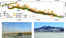
Fig. 1
Location of study area and sites and land surface properties in Semburi and Changguo, respectively"

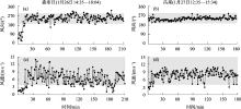
Fig. 2
Wind speed and direction during field experiments"

Tab. 1
Averaged five-layer wind speeds and its reduction amplitude at Semburi and Changguo"
| 高度/cm | S1风速/(m·s-1) | 降幅/% | S2风速/(m·s-1) | 降幅/% | 高度/cm | C1风速/(m·s-1) | 降幅/% | C2风速/(m·s-1) | 降幅/% |
|---|---|---|---|---|---|---|---|---|---|
| 180 | 6.43±2.19 | 31 | 6.36±2.27 | 30 | 170 | 8.12±1.61 | 7 | 7.77±1.67 | 6 |
| 90 | 4.44±1.97 | 36 | 4.45±2.05 | 32 | 80 | 7.59±1.44 | 9 | 7.30±1.62 | 16 |
| 40 | 2.86±1.47 | 45 | 3.02±1.35 | 29 | 30 | 6.88±1.27 | 12 | 6.12±1.51 | 5 |
| 20 | 1.56±0.98 | 58 | 2.15±1.18 | 31 | 10 | 6.07±1.08 | 21 | 5.83±1.27 | 21 |
| 8 | 0.65±0.37 | 89 | 1.49±0.79 | 77 | 5 | 4.80±0.78 | 40 | 4.58±1.07 | 41 |
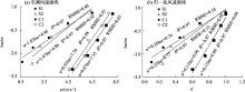
Fig. 3
Wind profile"
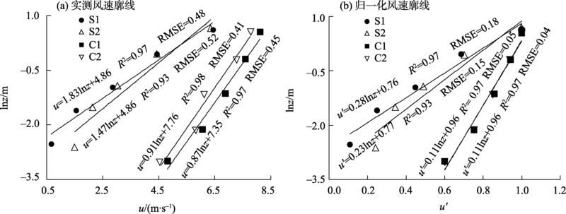
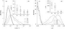
Fig. 4
Probability density curves of u* and z0"


Fig. 5
Relationship between threshold friction velocity (u*) and averaged wind speed (u)"
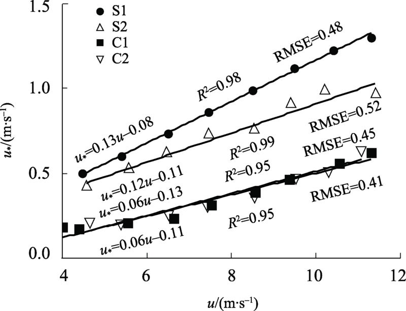
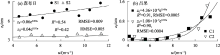
Fig. 6
Relationship between aerodynamic roughness length (z0) and averaged wind speed (u)"
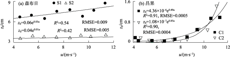
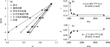
Fig. 7
Normalized wind speed profiles of naturally flat bare sand surfaces at high and low altitudes areas and coefficient c and d versus altitude"

Tab. 2
Normalized wind speed profile parameters for each station"
| 地点 | 海拔/m | c | d | R2 | RMSE |
|---|---|---|---|---|---|
| 塔中[ | 1099 | 0.23 | 0.88 | 0.98 | 0.04 |
| 敦煌沙漠[ | 1139 | 0.16 | 0.92 | 0.99 | 0.08 |
| 库布齐风电场[ | 1200 | 0.13 | 0.93 | 0.99 | 0.03 |
| 巴丹吉林拐子湖[ | 1390 | 0.12 | 0.94 | 0.98 | 0.06 |
| 中卫风沙观测场[ | 1650 | 0.11 | 0.94 | 0.98 | 0.05 |
| 昌果 | 3650 | 0.11 | 0.96 | 0.99 | 0.18 |
| [1] | 史培军, 严平, 袁艺. 中国北方风沙活动的驱动力分析[J]. 第四纪研究, 2001, 21(1): 41-47. |
| [Shi Peijun, Yan Ping, Yuan Yi. The driving factors of the blown-sand activity in Northern China[J]. Quaternary Sciences, 2001, 21(1): 41-47.] | |
| [2] |
Dong Z B, Hu G Y, Qian G Q, et al. High-altitude aeolian research on the Tibetan Plateau[J]. Reviews of Geophysics, 2017, 55(4): 864-901.
doi: 10.1002/2017RG000585 |
| [3] | Bagnold R A. The Physics of Blown Sand and Desert Dunes[M]. New York: Methuen, 1941: 85-95. |
| [4] |
Dupont S, Rajot J L, Labiadh M, et al. Aerodynamic parameters over an eroding bare surface:Reconciliation of the law of the wall and eddy covariance determinations[J]. Journal of Geophysical Research: Atmospheres, 2018, 123(9): 4490-4508.
doi: 10.1029/2017JD027984 |
| [5] | Stull R B. An Introduction to Boundary Layer Meteorology[M]. New York: Kluwer Academic Publishers, 1988: 378-381. |
| [6] | 杨兴华, 康永德, 周成龙, 等. 塔克拉玛干沙漠土壤粒度分布特征及其对粉尘释放的影响[J]. 农业工程学报, 2020, 36(5): 167-174. |
| [Yang Xinghua, Kang Yongde, Zhou Chenglong, et al. Characteristics of soil particle size distribution and its effect on dust emission in Taklimakan Desert[J]. Transaction of the Chinese Society of Agricultural Engineering, 2020, 36(5): 167-174.] | |
| [7] | Dong Z B, Liu X P, Wang H T. The aerodynamic roughness with a blowing sand boundary layer (BSBL): A redefinition of the owen effect[J]. Geophysical Research Letters, 2003, 30(2): 1047. |
| [8] | 吴正. 风沙地貌与治沙工程学[M]. 北京: 科学出版社, 2003: 10-20. |
| [Wu Zheng. Geomorphology of Wind Drift Sand and Their Controlled Engineering[M]. Beijing: Science Press, 2003: 10-20.] | |
| [9] | 茅宇豪, 刘树华, 李婧. 不同下垫面空气动力学参数的研究[J]. 气象学报, 2006, 64(3): 325-334. |
| [Mao Yuhao, Liu Shuhua, Li Jing. Study of aerodynamic parameters for different underling surfaces[J]. Acta Meteorologica Sinica, 2006, 64(3): 325-334.] | |
| [10] | 何玉斐, 张宏升, 刘明星, 等. 戈壁下垫面空气动力学参数确定的再研究[J]. 北京大学学报(自然科学版), 2009, 45(3): 439-443. |
| [He Yufei, Zhang Hongsheng, Liu Mingxing, et al. A study on determining aerodynamic parameters over Gobi Desert surface[J]. Acta Scientiarum Naturalium Universitatis Pekinensis, 2009, 45(3): 439-443.] | |
| [11] | 周杰, 雷加强, 郑则浩, 等. 塔里木盆地西南缘不同下垫面的摩阻风速和空气动力学粗糙度[J]. 水土保持通报, 2016, 36(1): 1-5, 10. |
| [Zhou Jie, Lei Jiaqiang, Zheng Zehao, et al. Friction wind velocity and aerodynamic roughness over different underlying surface types in southwestern Tarim Basin[J]. Bulletin of Soil and Water Conservation, 2016, 36(1): 1-5, 10.] | |
| [12] | 张焱, 马鹏飞, 曾林, 等. 基于沉积物理化性质的雅鲁藏布江中游粉尘物源研究[J]. 中国沙漠, 2021, 41(3): 92-100. |
| [Zhang Yan, Ma Pengfei, Zeng Lin, et al. Study on silt and clay provenance in the Yarlung Zangbo River middle reaches using sediment physicochemical characteristics[J]. Journal of Desert Research, 2021, 41(3): 92-100.] | |
| [13] |
Shao Y P, Lu H. A simple expression for wind erosion threshold friction[J]. Journal of Geophysical Research Atmospheres, 2000, 105(D17): 22437-22443.
doi: 10.1029/2000JD900304 |
| [14] | 李森, 杨萍, 董玉祥, 等. 西藏土地沙漠化及其防治[M]. 北京: 科学出版社, 2010: 90-98. |
| [Li Sen, Yang Ping, Dong Yuxiang, et al. Land Desertification and Its Control in Tibet[M]. Beijing: Science Press, 2010: 90-98.] | |
| [15] | Han Y X, Fang X M, Kang S C, et al. Shifts of dust source regions over central Asia and the Tibetan Plateau: Connections with the Arctic oscillation and the westerly jet[J]. Atmospheric Envireonment, 2008, 42(10): 2358-2368. |
| [16] | 马鹏飞, 张正偲, 论珠群培, 等. 雅鲁藏布江曲水-泽当段风沙活动动力条件分析与风沙灾害防治建议[J]. 中国沙漠, 2021, 41(1): 10-18. |
| [Ma Pengfei, Zhang Zhengcai, Lunzhu Qunpei, et al. Analysis on the sand transport wind power conditions and suggestions on the sand disaster preventions in the middle reaches of Yarlung Zangbo River, China[J]. Journal of Desert Research, 2021, 41(1): 10-18.] | |
| [17] | 马鹏飞, 论珠群培, 张焱, 等. 雅鲁藏布江中游江心洲、河漫滩面积及其指示的沙源特征[J]. 中国沙漠, 2021, 41(3): 25-33. |
| [Ma Pengfei, Lunzhu Qunpei, Zhang Yan, et al. Sand supplement characteristics indicated by the area of river inland, flood plain in the riverbed of the Yarlung Zangbo River[J]. Journal of Desert Research, 2021, 41(3): 25-33.] | |
| [18] |
杨军怀, 夏敦胜, 高福元, 等. 雅鲁藏布江流域风成沉积研究进展[J]. 地球科学进展, 2020, 35(8): 863-877.
doi: 10.11867/j.issn.1001-8166.2020.066 |
|
[Yang Junhuai, Xia Dunsheng, Gao Fuyuan, et al. Aeolian deposits in the Yarlung Zangbo River Basin, southern Tibetan Plateau: A brief review[J]. Advances in Earth Science, 2020, 35(8): 863-877.]
doi: 10.11867/j.issn.1001-8166.2020.066 |
|
| [19] | 杨萍, 魏兴琥, 董玉祥, 等. 西藏沙漠化研究进展与未来防沙治沙思路[J]. 中国科学院院刊, 2020, 35(6): 699-708. |
| [Yang Ping, Wei Xinghu, Dong Yuxiang, et al. Progress on study desertification research and future combating idea in Tibet, China[J]. Bulletin of Chinese Academy of Sciences, 2020, 35(6): 699-708.] | |
| [20] | 落桑曲加, 张焱, 马鹏飞, 等. 雅鲁藏布江中游不同地表输沙量特征[J]. 中国沙漠, 2022, 42(2): 6-13. |
| [Luosang Qujia, Zhang Yan, Ma Pengfei, et al, Study on the sand transport quantities on the different landscapes in the middle area of Yarlung Zangbo River[J]. Journal of Desert Research, 2022, 42(2): 6-13.] | |
| [21] |
Lettau H. Note on aerodynamic roughness-parameter estimation on the basis of roughness element description[J]. Journal of Applied Meteorology, 1969, 8(5): 828-832.
doi: 10.1175/1520-0450(1969)008<0828:NOARPE>2.0.CO;2 |
| [22] |
Li X B, Bo T L. Statistics and spectra of turbulence under different roughness in the near-neutral atmospheric surface layer[J]. Earth Surface Processes and Landforms, 2019, 44(7): 1460-1470.
doi: 10.1002/esp.4588 |
| [23] | Mohammadreza K, David T, Gerard M. A review on turbulent flow over rough surfaces: Fundamentals and theories[J]. International Journal of Thermofluids, 2021, 10(1): 1-34. |
| [24] |
John F. Turbulence in plant canopies[J]. Annual Review of Fluid Mechanics, 2000, 32: 519-571.
doi: 10.1146/annurev.fluid.32.1.519 |
| [25] | 张强, 曾剑, 姚桐. 植被下垫面近地层大气动力状态与动力学粗糙长度的相互作用及其参数化关系[J]. 科学通报, 2012, 57(8): 647-655. |
| [Zhang Qiang, Zeng Jian, Yao Tong. Interaction of aerodynamic roughness length and windflow conditions and its parameterization over vegetation surface[J]. Chinese Science Bulletin, 2012, 57(8): 647-655.] | |
| [26] | 程宏, 邹学勇, 张春来. 摩阻风速与平均风速的转化关系研究[J]. 水土保持研究, 2007, 61(2): 133-134, 138. |
| [Chen Hong, Zou Xueyong, Zhang Chunlai. A study on the relationship between friction wind velocity and mean wind velocity[J]. Research of Soil and Water Conservation, 2007, 61(2): 133-134, 138.] | |
| [27] | 杨兴华, 艾力·买买提明 张瑞军, 等. 塔克拉玛干沙漠荒漠过渡带空气动力学粗糙度分析[J]. 干旱区研究, 2012, 29(3): 524-528. |
| [Yang Xinghua, Ali Mamtimin, Zhang Ruijun, et al. Analysis on aerodynamic roughness length in a desert transitional zone of the Taklimakan desert[J]. Arid Zone Research, 2012, 29(3): 524-528.] | |
| [28] |
Zhang C L, Lia Q, Zhou N, et al. Field observations of wind profiles and sand fluxes above the windward slope of a sand dune before and after the establishment of semi-buried straw checkerboard barriers[J]. Aeolian Research, 2016, 20: 59-70.
doi: 10.1016/j.aeolia.2015.11.003 |
| [29] | 高咏晴, 亢力强, 张军杰, 等. 风沙流和净风场中瞬时水平风速廓线特征比较[J]. 中国沙漠, 2017, 37(1): 48-56. |
| [Gao Yongqing, Kang Liqinag, Zhang Junjie, et al. Comparison of instantaneous horizontal wind velocity profile in aeolian sand transport and clean air[J]. Journal of Desert Research, 2017(37): 48-56.] | |
| [30] | 王翠, 李生宇, 雷加强, 等. 不同下垫面沙通量估算——以策勒绿洲-沙漠过渡带为例[J]. 干旱区地理, 2017, 40(3): 533-540. |
| [Wang Cui, Li Shengyu, Lei Jiaqiang, et al. Sand flux estimation of different underlying surface, a case of Cele oasis-desert ecotone[J]. Arid Land Geography, 2017, 40(3): 533-540.] | |
| [31] | 李汉林, 何清, 金莉莉. 塔克拉玛干沙漠腹地和北缘典型天气近地层风速廓线特征[J]. 干旱气象, 2020, 38(6): 965-978. |
| [Li Hanlin, He Qing, Jin Lili. Wind profile characteristic of near-surface layer under typical weather conditions in the hinterland and northern margin of Taklimakan Desert[J]. Journal of Arid Meteorology, 2020, 38(6): 965-978.] | |
| [32] | 胡菲, 张克存, 安志山, 等. 敦煌沙漠、绿洲和戈壁地表风动力环境特征同步对比[J]. 中国沙漠, 2020, 40(4): 113-119. |
| [Hu Fei, Zhang Kecun, An Zhishan, et al. Comparison of wind dynamic environment among desert, oasis and Gobi[J]. Journal of Desert Research, 2020, 40(4): 113-119.] | |
| [33] |
贾瑞庭, 蒙仲举, 党晓宏, 等. 库布齐沙漠200 MWp光伏阵列的截流阻沙效应研究[J]. 中国农业科技导报, 2021, 23(4): 137-144.
doi: 10.13304/j.nykjdb.2020.0586 |
|
[Jia Ruiting, Meng Zhongju, Dang Xiaohong, et al. Study on the intercepting and blocking sand effect of 200 MWp photovoltaic array in Kubuqi Desert[J]. Journal of Agricultural Science and Technology, 2021, 23(4): 137-144.]
doi: 10.13304/j.nykjdb.2020.0586 |
|
| [34] | 何清, 胡文峰, 杨兴华, 等. 巴丹吉林沙漠拐子湖地区贴地层风速廓线和风沙流结构特征[J]. 干旱区研究, 2012, 29(3): 517-523. |
| [He Qing, Hu Wenfeng, Yang Xinghua, et al. Research on wind profile and sand drift structure in Guaizi Lake Region in the Badain Jaran Desert[J]. Arid Zone Research, 2012, 29(3): 517-523.] | |
| [35] | 张正偲, 董治宝, 赵爱国, 等. 沙漠地区风沙活动特征——以中国科学院风沙观测场为例[J]. 干旱区研究, 2007, 24(4): 550-555. |
| [Zhang Zhengcai, Dong Zhibao, Zhao Aiguo, et al. Features of sand drift movement in desert: A case study at sand drift observation station of Chinese Academy of Sciences[J]. Arid Zone Research, 2007, 24(4): 550-555.] |
| [1] | YANG Xinghua,MA Mingjie,ZHOU Chenglong,HE Qing. Comparative study of the applicability of emission threshold determining method in the Taklimakan Desert [J]. Arid Zone Research, 2022, 39(4): 1006-1016. |
| [2] | ZHANG Ke-Cun, ZHANG Wei-Min, QU Jian-Jun, AN Zhi-Shan, TAN Li-Hai. Study on Dynamic Properties of Gobi Surface with Different Gravel Coverage [J]. , 2012, 29(6): 1077-1082. |
| [3] | YANG Xing-Hua, AI Li-·Mai-Mai-Ti-Ming, ZHANG Rui-Jun, HE Qing, HUO Wen. Analysis on Aerodynamic Roughness Length in a Desert Transitional Zone of the Taklimakan Desert [J]. , 2012, 29(3): 524-528. |
|
||