Arid Zone Research ›› 2025, Vol. 42 ›› Issue (5): 829-839.doi: 10.13866/j.azr.2025.05.06
• Land and Water Resources • Previous Articles Next Articles
TU Yike1,2( ), HAN Wenguang3, ZHANG Erdong3, LI Hao3, REN Li1, LI Qiongfang1,4()
Received:2025-01-14
Revised:2025-03-30
Online:2025-05-15
Published:2025-10-22
Contact:
LI Qiongfang
E-mail:tuyike927@163.com;qfli@hhu.edu.cn
TU Yike, HAN Wenguang, ZHANG Erdong, LI Hao, REN Li, LI Qiongfang. Evaluation of water and soil resources carrying capacity based on the DPSIR-Cloud Model coupling: A case study of the irrigation area on the south bank of the Yellow River in Inner Mongolia[J].Arid Zone Research, 2025, 42(5): 829-839.
Add to citation manager EndNote|Reference Manager|ProCite|BibTeX|RefWorks
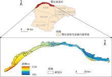
Fig. 1
Map of the study area"

Tab. 1
Data sources of evaluation indicators"
| 评价指标 | 数据性质 | 数据来源 |
|---|---|---|
| 人均GDP、人口自然增长率、第三产业和农业GDP占比、 城镇化率、人口密度等 | 经济社会数据 | 《鄂尔多斯市统计年鉴(2023)》 |
| 单位耕地面积农用化肥施用量、农作物播种面积、农作 物耕种收综合机械化率等 | 农业生产数据 | 南岸灌区各县市《国民经济和社会发展统计公报(2023)》 |
| 年降水量、人均水资源量、农田灌溉单位面积平均用水 量、农田灌溉水有效利用率等 | 水资源利用数据 | 《鄂尔多斯市水资源公报(2023)》 |
| 万元GDP用水量、人均综合用水量、地下水源供水量 占比等 | 水资源利用数据 | 《鄂尔多斯市水资源综合利用与保护规划》 |
| 水土保持率、水土流失治理率、垦殖率等 | 生态发展数据 | 《鄂尔多斯市水土保持公报》 |
Tab. 2
Comprehensive evaluation index system of water and soil resources carrying capacity in the irrigation area on the south bank of the Yellow River in Inner Mongolia"
| 目标层 | 准则层 | 指标层 | 指标代号 | 单位 | 指标含义 | 指标性质 |
|---|---|---|---|---|---|---|
| 水土资源 承载力 | 驱动力(Driving force) | 人均GDP | X1 | 104元 | 反映区域经济发展状况的宏观指标 | + |
| 人均水资源量 | X2 | m3·人-1 | 反映区域水资源丰裕与匮乏的状况 | + | ||
| 农作物播种面积 | X3 | 104 hm2 | 反映区域内农作物播种情况 | + | ||
| 年降水量 | X4 | mm | 反映研究区自然降水补给的程度 | + | ||
| 产水模数 | X5 | 104 m3·km-2 | 反映水资源的动态变化 | + | ||
| 人口自然增长率 | X6 | ‰ | 反映人口对区域资源的动态压力 | - | ||
| 压力(Pressure) | 万元GDP用水量 | X7 | m3·(104元)-1 | 反映水资源与经济的协调程度 | - | |
| 人均综合用水量 | X8 | m3 | 反映居民用水压力 | - | ||
| 农田单位面积灌溉水量 | X9 | m3·hm-2 | 反映农业用水水平 | - | ||
| 单位耕地面积农用化肥施用量 | X10 | t·hm-2 | 反映农用化肥使用情况 | - | ||
| 状态(State) | 水土资源匹配系数 | X11 | 104 m3·hm-2 | 反映水土资源匹配程度 | + | |
| 第三产业占比 | X12 | % | 反映区域经济结构的优化程度 | + | ||
| 地下水源供水量占比 | X13 | % | 反映地下水利用程度 | - | ||
| 水土保持率 | X14 | % | 反映区域内水土保持总体状况 | + | ||
| 影响(Impact) | 城镇化率 | X15 | % | 反映社会发展水平和人口素质 | - | |
| 垦殖率 | X16 | % | 反映耕地情况 | + | ||
| 农田灌溉水有效利用率 | X17 | % | 反映农业技术水平 | + | ||
| 单位耕地粮食产出 | X18 | t·km-2 | 反映土地生产水平 | + | ||
| 农业GDP占比 | X19 | % | 反映农业经济情况 | - | ||
| 响应(Response) | 人口密度 | X20 | 人·km-2 | 反映人口密集情况 | - | |
| 水土流失治理率 | X21 | ‰ | 反映区域水土流失治理程度 | + | ||
| 农村生活污水治理率 | X22 | % | 反映农村生活污水治理水平 | + | ||
| 农作物耕种收综合机械化率 | X23 | % | 反映农业现代化水平 | - |
Tab. 3
Classification of bearing state of water and soil resources carrying capacity in the irrigation area"
| 承载力 | 等级 | 资源承载特征 |
|---|---|---|
| 承载良好 | Ⅰ | 区域生态功能完善,水土资源系统处于低压低损状态,水土资源与社会经济发展系统很稳定,处于可持续状态 |
| 承载安全 | Ⅱ | 区域生态功能较完善,水土资源能满足社会经济发展,环境系统完善,抗外界干扰能力强 |
| 承载临界 | Ⅲ | 区域生态功能相对完善,能够较好满足社会经济发展,环境系统稳定 |
| 轻微承载 | Ⅳ | 区域生态功能处于轻微受损状态,水土资源与社会经济平衡发展的状态被破坏,系统不稳定 |
| 严重承载 | Ⅴ | 区域生态环境受到破坏,水土资源承载力已接近饱和,不能满足社会经济发展,环境系统存在缺陷,抗外界干扰能力弱且敏感 |
Tab. 4
Grading standards for evaluation indicators of water and soil resources carrying capacity in the irrigation area"
| 指标代号 | 评价标准 | ||||
|---|---|---|---|---|---|
| Ⅰ | Ⅱ | Ⅲ | Ⅳ | Ⅴ | |
| X1 | >15 | [12,15] | [8,12) | [3,8) | <3 |
| X2 | >2200 | [1700,2200] | [1000,1700) | [500,1000) | <500 |
| X3 | >40 | [30,40] | [20,30) | [10,20) | <10 |
| X4 | >800 | [600,800] | [400,600) | [200,400) | <200 |
| X5 | >50 | [30,50] | [20,30) | [10,20) | <10 |
| X6 | <2 | [2,4) | [4,5) | [5,6] | >6 |
| X7 | <30 | [30,80) | [80,140) | [140,220) | >220 |
| X8 | <400 | [400,550) | [550,700) | [700,950] | >950 |
| X9 | <1500 | [1500,3000) | [3000,4500) | [4500,6000] | >6000 |
| X10 | <0.6 | [0.6,1) | [1,1.5) | [1.5,1.95) | >1.95 |
| X11 | >1 | [0.7,1] | [0.4,0.7) | [0.15,0.4) | <0.15 |
| X12 | >60 | [50,60) | [40,50) | [30,40) | <30 |
| X13 | <15 | [15,20) | [20,35) | [35,50) | >50 |
| X14 | >80 | [70,80) | [55,70) | [30,55) | <30 |
| X15 | <40 | [40,50) | [50,60) | [60,70] | >70 |
| X16 | >50 | [41.4,50.0] | [27.7,41.4) | [13.8,27.6) | <13.8 |
| X17 | >80 | [60,80] | [40,60) | [20,40) | <20 |
| X18 | >9 | [6,9] | [3.5,6) | [2.5,3.5) | <2.5 |
| X19 | <10 | [10,20) | [20,30) | [30,40] | >40 |
| X20 | <50 | [50,100) | [100,200) | [200,300] | >300 |
| X21 | >3 | [1.5,3] | [1,1.5) | [0.6,1) | <0.6 |
| X22 | >45 | [35,45] | [30,35) | [20,30) | <20 |
| X23 | >95 | [90,95] | [80,90) | [60,80) | <60 |
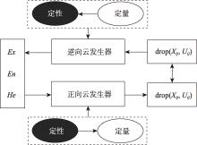
Fig. 2
Schematic diagram of cloud generator"

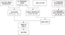
Fig. 3
Flow chart of comprehensive evaluation of water and soil resources carrying capacity based on cloud model"

Tab. 5
Calculation results of weight of water and soil resource carrying capacity indicators"
| 准则层 | 指标 代号 | AHP法 权重 | 熵权法 权重 | 组合赋权 法权重 | 准则层 权重 |
|---|---|---|---|---|---|
| 驱动力 | X1 | 0.0294 | 0.0122 | 0.0189 | 0.4455 |
| X2 | 0.1164 | 0.2321 | 0.1545 | ||
| X3 | 0.0516 | 0.0182 | 0.0326 | ||
| X4 | 0.0585 | 0.1018 | 0.0699 | ||
| X5 | 0.0516 | 0.0194 | 0.0328 | ||
| X6 | 0.0226 | 0.2289 | 0.1369 | ||
| 压力 | X7 | 0.0445 | 0.0035 | 0.0266 | 0.2245 |
| X8 | 0.0336 | 0.0005 | 0.0200 | ||
| X9 | 0.0954 | 0.0035 | 0.0568 | ||
| X10 | 0.0119 | 0.2033 | 0.1212 | ||
| 状态 | X11 | 0.1355 | 0.0003 | 0.0806 | 0.1537 |
| X12 | 0.0677 | 0.0228 | 0.0425 | ||
| X13 | 0.0078 | 0.0069 | 0.0062 | ||
| X14 | 0.0166 | 0.0376 | 0.0244 | ||
| 影响 | X15 | 0.0252 | 0.0054 | 0.0153 | 0.1439 |
| X16 | 0.0893 | 0.0097 | 0.0535 | ||
| X17 | 0.0767 | 0.0361 | 0.0504 | ||
| X18 | 0.0142 | 0.0039 | 0.0087 | ||
| X19 | 0.0192 | 0.0187 | 0.0159 | ||
| 响应 | X20 | 0.0105 | 0.0039 | 0.0066 | 0.0324 |
| X21 | 0.0090 | 0.0012 | 0.0054 | ||
| X22 | 0.0069 | 0.0259 | 0.0159 | ||
| X23 | 0.0061 | 0.0042 | 0.0044 |
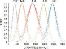
Fig. 4
Standard cloud of carrying capacity assessment"

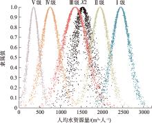
Fig. 5
Cloud map of comprehensive elvaluation result"

Tab. 6
Evaluation results of comprehensive membership degree of water and soil resources carrying capacity in the irrigation area on the south bank of the Yellow River in Inner Mongolia in 2023"
| 准则层 | 评价标准 | 等级 | ||||
|---|---|---|---|---|---|---|
| Ⅰ | Ⅱ | Ⅲ | Ⅳ | Ⅴ | ||
| D(驱动力) | 0.1361 | 0.0269 | 0.1855 | 0.0540 | 0.0543 | Ⅲ |
| P(压力) | 0.1337 | 0.0441 | 0.0268 | 0.0154 | 0.0043 | Ⅰ |
| S(状态) | 0.0000 | 0.0008 | 0.0158 | 0.0637 | 0.0734 | Ⅴ |
| I(影响) | 0.0023 | 0.0148 | 0.0652 | 0.0055 | 0.0533 | Ⅲ |
| R(响应) | 0.0004 | 0.0154 | 0.0128 | 0.0034 | 0.0002 | Ⅱ |
| 南岸灌区 | 0.2725 | 0.1020 | 0.3060 | 0.1420 | 0.1855 | Ⅲ |
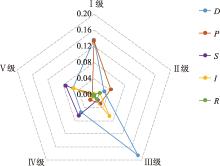
Fig. 6
Degree radar map various grades of water and soil resources carrying capacity"

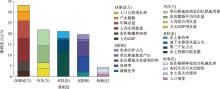
Fig. 7
Degree of major obstacle factors of water and soil resources carrying capacity in the irrigation area on the south bank of the Yellow River in 2023"

Tab. 7
Error analysis of evaluation results"
| 综合评价云模型隶属度向量 | 模糊综合 评判模型 | 误差值 |
|---|---|---|
| (0.2725, 0.1020, 0.3060, 0.1420, 0.1855) | 0.3109 | 1.58% |
| [1] | 王宇璇, 屈忠义, 白燕英, 等. 基于Sentinel-2影像的黄河南岸典型改良示范区土壤含盐量反演模型[J]. 农业机械学报, 2024, 55(4): 290-299. |
| [Wang Yuxuan, Qu Zhongyi, Bai Yanying, et al. Soil salt inversion of typical improvement demonstration area of South Bank of Yellow River based on Sentinel-2images[J]. Transactions of the Chinese Society for Agricultural Machinery, 2024, 55(4): 290-299.] | |
| [2] | 陈宇, 刘燕, 赵志强. 交口灌区农业水土资源承载力评价及障碍因子诊断[J]. 灌溉排水学报, 2024, 43(7): 98-105. |
| [Chen Yu, Liu Yan, Zhao Zhiqiang. The carrying capacity of agricultural soil and water resources and its determinants in Jiaokou Irrigation District[J]. Journal of Irrigation and Drainage, 2024, 43(7): 98-105.] | |
| [3] |
吴思源, 郝利娜. 2001—2021年黄河流域植被覆盖变化及其驱动因素[J]. 干旱区研究, 2024, 41(8): 1373-1384.
doi: 10.13866/j.azr.2024.08.11 |
|
[Wu Siyuan, Hao Lina. Changes in vegetation cover and driving factors in the Yellow River Basin from 2001 to 2021[J]. Arid Zone Research, 2024, 41(8): 1373-1384.]
doi: 10.13866/j.azr.2024.08.11 |
|
| [4] | 李天霄, 付强, 彭胜民. 基于DPSIR模型的水土资源承载力评价[J]. 东北农业大学学报, 2012, 43(8): 128-134. |
| [Li Tianxiao, Fu Qiang, Peng Shengmin. Evaluation of water and soil resources carrying capacity based on DPSIR frame work[J]. Journal of Northeast Agricultural University, 2012, 43(8): 128-134.] | |
| [5] | 李慧, 周维博, 庄妍, 等. 延安市农业水土资源匹配及承载力[J]. 农业工程学报, 2016, 32(5): 156-162. |
| [Li Hui, Zhou Weibo, Zhuang Yan, et al. Agricultural water and soil resources matching patterns and carrying capacity in Yan’an City[J]. Transactions of the Chinese Society of Agricultural Engineering, 2016, 32(5): 156-162.] | |
| [6] | 郑久瑜, 赵西宁, 操信春, 等. 河套灌区农业水土资源时空匹配格局研究[J]. 水土保持研究, 2015, 22(3): 132-136. |
| [Zheng Jiuyu, Zhao Xining, Cao Xinchun, et al. Study on spatiotemporal matching pattern of agricultural water and land resources in Hetao Irrigation District[J]. Research of Soil and Water Conservation, 2015, 22(3): 132-136.] | |
| [7] | 邹全程, 伍昊洋, 叶威, 等. 基于PSO-PPE模型的宁夏扬水灌区水土资源承载力综合评价[J]. 水资源与水工程学报, 2019, 30(4): 250-256. |
| [Zou Quancheng, Wu Haoyang, Ye Wei, et al. Comprehensive evaluation of soil and water resource carrying capacity in Ningxia Irrigation Area based on PSO-PPE model[J]. Journal of Water Resources and Water Engineering, 2019, 30(4): 250-256.] | |
| [8] | 王云生. 乡村振兴战略下吉林省农业支持保护政策体系研究[D]. 长春: 吉林大学, 2021. |
| [Wang Yunsheng. Research on Agricultural Support and Protection Policy System in Jilin Province under the Background of Rural Revitalization[D]. Changchun: Jilin University, 2021.] | |
| [9] | Roberts I, Griffiths R. A model for the evaporation of droplets from sand[J]. Atmospheric Environment, 1995, 29(11): 1307-1317. |
| [10] | 曲绅豪, 姚怀柱, 王彦东, 等. 江苏典型灌区农业水土资源匹配现状及其承载力特征[J]. 水土保持研究, 2023, 30(6): 452-457. |
| [Qu Shenhao, Yao Huaizhu, Wang Yandong, et al. Matching status and bearing capacity characteristics of agricultural water and land resources in typical irrigation districts of Jiangsu Province[J]. Research of Soil and Water Conservation, 2023, 30(6): 452-457.] | |
| [11] | 施开放, 刁承泰, 孙秀锋. 基于熵权可拓决策模型的重庆三峡库区水土资源承载力评价[J]. 环境科学学报, 2013, 33(2): 609-616. |
| [Shi Kaifang, Diao Chengtai, Sun Xiufeng. Evaluation of soil-water resources carrying capacity based on entropy weight extension decision model in the Three Gorges Reservoir Region of Chongqing[J]. Acta Scientiae Circumstantiae, 2013, 33(2): 609-616.] | |
| [12] |
孙佳歆, 齐鹏, 章光新, 等. 基于生态足迹法的农业水土资源承载力分析——以三江平原友谊农场为例[J]. 地理科学, 2024, 44(6): 1060-1068.
doi: 10.13249/j.cnki.sgs.20221284 |
|
[Sun Jiaxin, Qi Peng, Zhang Guangxin, et al. Agricultural water and land resources carrying capacity based on ecological footprint method: A case of Youyi Farm in Sanjiang Plain[J]. Scientia Geographica Sinica, 2024, 44(6): 1060-1068.]
doi: 10.13249/j.cnki.sgs.20221284 |
|
| [13] | 李晓燕, 郝晋珉, 陈爱琪. 山东省农业水土资源时空匹配格局及评价研究[J]. 中国农业大学学报, 2020, 25(11): 1-11. |
| [Li Xiaoyan, Hao Jinmin, Chen Aiqi. Time-space matching pattern and evaluation of agricultural water and soil resources in Shandong Province[J]. Journal of China Agricultural University, 2020, 25(11): 1-11.] | |
| [14] | 姜秋香, 赵蚰竹, 王子龙, 等. 系统动力学在水土资源系统中的应用研究进展[J]. 东北农业大学学报, 2017, 48(7): 91-96. |
| [Jiang Qiuxiang, Zhao Youzhu, Wang Zilong, et al. Research advance on the system dynamics used in the soil and water resources[J]. Journal of Northeast Agricultural University, 2017, 48(7): 91-96.] | |
| [15] | 梁军. 河南省水土资源承载力评价研究[J]. 河南水利与南水北调, 2023, 52(12): 27-28, 62. |
| [Liang Jun. Study on the evaluation of the carrying capacity of water and soil resources in Henan Province[J]. Water Resources and South-to-North Water Diversion, 2023, 52(12): 27-28, 62.] | |
| [16] | 朱薇, 周宏飞, 李兰海, 等. 哈萨克斯坦农业水土资源承载力评价及其影响因素识别[J]. 干旱区研究, 2020, 37(1): 254-263. |
| [Zhu Wei, Zhou Hongfei, Li Lanhai, et al. Evaluation on carrying capacity of agricultural water and land resources and identification of affecting factors in Kazakhstan[J]. Arid Zone Research, 2020, 37(1): 254-263.] | |
| [17] | 赵晨程, 高玉琴, 刘钺, 等. 基于云模型的生态河道建设评价[J]. 水资源保护, 2022, 38(2): 183-189. |
| [Zhao Chencheng, Gao Yuqin, Liu Yue, et al. Evaluation of ecological river construction based on cloud model[J]. Water Resources Protection, 2022, 38(2): 183-189.] | |
| [18] | 季晓翠, 王建群, 傅杰民. 基于云模型的滨海小流域水生态文明评价[J]. 水资源保护, 2019, 35(2): 74-79. |
| [Ji Xiaocui, Wang Jianqun, Fu Jiemin. Evaluation of water ecological civilization in small coastal watershed based on cloud model[J]. Water Resources Protection, 2019, 35(2): 74-79.] | |
| [19] | 李德毅, 刘常昱. 论正态云模型的普适性[J]. 中国工程科学, 2004, 6(8): 28-34. |
| [Li Deyi, Liu Changyu. Study on the universality of the Normal Cloud Model[J]. Strategic Study of CAE, 2004, 6(8): 28-34.] | |
| [20] |
Wharfe J. Hazardous chemicals in complex mixtures: A role for direct toxicity assessment[J]. Ecotoxicology, 2004, 13(5): 413-421.
pmid: 15462133 |
| [21] |
Jago-On K A B, Kaneko S, Fujikura R, et al. Urbanization and subsurface environmental issues: An attempt at DPSIR model application in Asian cities[J]. Science of the Total Environment, 2009, 407(9): 3089-3104.
doi: 10.1016/j.scitotenv.2008.08.004 pmid: 18922564 |
| [22] | Saaty T L. How to make a decision: The analytic hierarchy process[J]. European Journal of Operational Research, 1990, 48(1): 9-26. |
| [23] | Shannon C E. A mathematical theory of communication[J]. Bell Systems Technical Journal, 1948, 27(4): 623-656. |
| [24] | 闫滨, 姜秀慧, 钟占华, 等. 基于改进权重的综合水质标识指数法的大伙房水库上游水质评价研究[J]. 沈阳农业大学学报, 2019, 50(3): 314-323. |
| [Yan Bin, Jiang Xiuhui, Zhong Zhanhua, et al. Water quality evaluation of the upstream of Dahuofang Reservoir based on comprehensive water quality identification index method of improved weight[J]. Journal of Shenyang Agricultural University, 2019, 50(3): 314-323.] | |
| [25] | 李德毅, 孟海军, 史雪梅. 隶属云和隶属云发生器[J]. 计算机研究与发展, 1995(6): 15-20. |
| [Li Deyi, Meng Haijun, Shi Xuemei. Membership clouds and membership clouds generators[J]. Journal of Computer Research and Development, 1995(6): 15-20.] | |
| [26] | Sawaya K E, Olmanson L G, Heinert N J, et al. Extending satellite remote sensing to local scales: Land and water resource monitoring using high-resolution imagery[J]. Remote Sensing of Environment, 2003, 88(1-2): 144-156. |
| [27] | 刘登峰, 王栋, 丁昊, 等. 水体富营养化评价的熵-云耦合模型[J]. 水利学报, 2014, 45(10): 1214-1222. |
| [Liu Dengfeng, Wang Dong, Ding Hao, et al. Eutrophication assessment by Entropy-Cloud Model[J]. Journal of Hydraulic Engineering, 2014, 45(10): 1214-1222.] | |
| [28] |
冀明欣, 冯天骄, 肖辉杰, 等. 河套灌区不同配置农田防护林对田间土壤水分和养分储量的影响[J]. 干旱区研究, 2023, 40(8): 1268-1279.
doi: 10.13866/j.azr.2023.08.07 |
|
[Ji Mingxin, Feng Tianjiao, Xiao Huijie, et al. Effects of different farmland shelterbelts on soil water and nutrient storage in the Hetao Irrigation District[J]. Arid Zone Research, 2023, 40(8): 1268-1279.]
doi: 10.13866/j.azr.2023.08.07 |
|
| [29] |
陆莹, 张敏, 王彦阁. 内蒙古黄河流域生态保护恢复优先区识别[J]. 干旱区研究, 2024, 41(11): 1946-1955.
doi: 10.13866/j.azr.2024.11.14 |
|
[Lu Ying, Zhang Min, Wang Yange. Identification of priority areas for the ecological protection and restoration of the Yellow River Basin in Inner Mongolia[J]. Arid Zone Research, 2024, 41(11): 1946-1955.]
doi: 10.13866/j.azr.2024.11.14 |
|
| [30] | Xu C, Wang X, Liu Z, et al. Analysis of the spatial and temporal evolution of water and soil resource carrying capacity in arid region of Northwest China[J]. Water Supply, 2022, 22(12): 8813-8834. |
| No related articles found! |
|
||