Arid Zone Research ›› 2022, Vol. 39 ›› Issue (6): 1930-1941.doi: 10.13866/j.azr.2022.06.23
• Ecology and Environment • Previous Articles Next Articles
PANG Haiwei1( ),YU Dian2,REN Chengbao2,ZHANG Yu1,ZHENG Caizhi1,GUO Jiacheng1,BIAN Zhen1(),SANG Guoqing1
Received:2022-04-20
Revised:2022-08-23
Online:2022-11-15
Published:2023-01-17
Contact:
Zhen BIAN
E-mail:1152700401@qq.com;stu_bianz@ujn.edu.cn
PANG Haiwei,YU Dian,REN Chengbao,ZHANG Yu,ZHENG Caizhi,GUO Jiacheng,BIAN Zhen,SANG Guoqing. Remote sensing classification characteristics of typical plant communities in the semi-arid areas of eastern Ningxia[J].Arid Zone Research, 2022, 39(6): 1930-1941.
Add to citation manager EndNote|Reference Manager|ProCite|BibTeX|RefWorks

Fig. 1
Distribution of study area and sampling area"

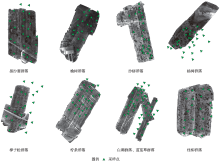
Fig. 2
Multispectral orthophoto images of typical plant communities and distribution of sampling points"

Tab. 1
Feature space used in object-oriented processes"
| 类别 | 数据层 | 对象属性名称 | 对象特征 |
|---|---|---|---|
| 光谱特征 | Coastal | Mean、Max、Brightness、Standard | 分割图层平均值、最大值、标准差及参与波段亮度加权平均值 |
| Blue | |||
| Green | |||
| Red | |||
| Nir | |||
| SWIR1 | |||
| SWIR2 | |||
| 植被指数 | NDVI | NDVI | 平均值和标准差 |
Tab. 2
Classification experiment grouping"
| 实验方案 | 波段组合 |
|---|---|
| A | 最优3波段(7月31日影像) |
| B | 最优3波段(7月31日影像)+波段1(2月21日影像) |
| C | 最优3波段(7月31日影像)+波段2(2月21日影像) |
| D | 最优3波段(7月31日影像)+波段3(2月21日影像) |
| E | 最优3波段(7月31日影像)+波段4(2月21日影像) |
| F | 最优3波段(7月31日影像)+波段5(2月21日影像) |
| G | 最优3波段(7月31日影像)+波段6(2月21日影像) |
| H | 最优3波段(7月31日影像)+波段7(2月21日影像) |
Tab. 3
List of plant community classification system"
| 植被 | 群系组 | 群落型 |
|---|---|---|
| 植被 | 盐生灌丛 | 白刺群落(Nitraria tangutorum) |
| 丛生禾草盐生草甸 | 芨芨草群落(Achnatherum splendens) | |
| 沙地落叶灌丛及半灌丛 | 柠条群落(Caragana microphylla) | |
| 黑沙蒿群落(Artemisia desertorum) | ||
| 沙地人工落叶灌木林 | 沙柳群落(Salix cheilophila.) | |
| 盐碱地人工落叶灌木林 | 柽柳群落(Tamarix chinensis) | |
| 人工寒温性针叶松林 | 樟子松群落(Pinus sylvestris var. mongolica) | |
| 人工温性落叶阔叶林 | 杨树群落(Populus ) | |
| 榆树群落(Ulmus pumila) |

Fig. 3
Spectral curve of typical plant community on February 21, 2021"


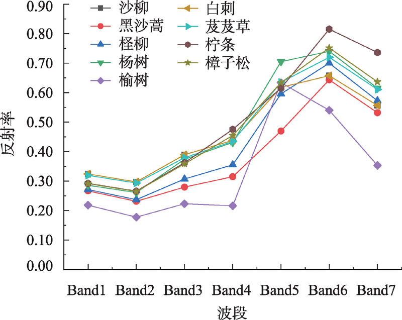
Fig. 4
Spectral curve of typical plant community on July 31,2021"
Tab. 4
Correlation matrix"
| Correlation | Band1 | Band2 | Band3 | Band4 | Band5 | Band6 | Band7 |
|---|---|---|---|---|---|---|---|
| Band 1 | 1.00 | ||||||
| Band 2 | 0.99 | 1.00 | |||||
| Band 3 | 0.98 | 0.99 | 1.00 | ||||
| Band 4 | 0.95 | 0.96 | 0.99 | 1.00 | |||
| Band 5 | 0.85 | 0.83 | 0.85 | 0.81 | 1.00 | ||
| Band 6 | 0.91 | 0.92 | 0.95 | 0.96 | 0.88 | 1.00 | |
| Band 7 | 0.90 | 0.91 | 0.95 | 0.97 | 0.82 | 0.99 | 1.00 |
Tab. 5
OIF value top 10 ranking combination"
| OIF值排序 | 波段组合 | 标准差和 | 相关系数和 | OIF |
|---|---|---|---|---|
| 1 | 4、5、7 | 3363.75 | 2.60 | 1293.63 |
| 2 | 5、6、7 | 3389.62 | 2.69 | 1261.78 |
| 3 | 4、5、6 | 3196.66 | 2.65 | 1206.68 |
| 4 | 4、6、7 | 3440.88 | 2.92 | 1179.95 |
| 5 | 3、5、7 | 3023.22 | 2.62 | 1153.20 |
| 6 | 2、5、7 | 2774.02 | 2.56 | 1082.91 |
| 7 | 3、6、7 | 3100.36 | 2.89 | 1071.73 |
| 8 | 3、4、5 | 2830.26 | 2.66 | 1065.43 |
| 9 | 3、5、6 | 2856.13 | 2.68 | 1064.29 |
| 10 | 1、5、7 | 2721.39 | 2.57 | 1058.27 |
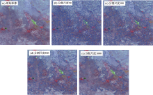
Fig. 5
Segmentation results under different segmentation scales"

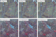
Fig. 6
Segmentation effect diagram with different compactness and shape factor configuration"

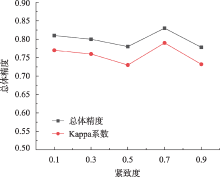
Fig. 7
Different compatness parameter setting classification accuracy"
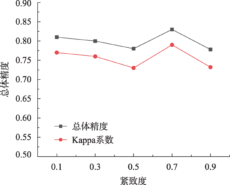

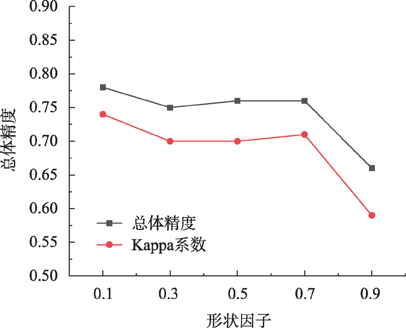
Fig. 8
Different shape parameter setting classification accuracy"
Tab. 6
Classification accuracy table"
| 波段组合 | 总体精度/% | Kappa系数 |
|---|---|---|
| A:4、5、7 | 75.74 | 0.71 |
| B:4、5、7+1 | 81.46 | 0.78 |
| C:4、5、7+2 | 82.15 | 0.79 |
| D:4、5、7+3 | 80.55 | 0.77 |
| E:4、5、7+4 | 83.98 | 0.81 |
| F:4、5、7+5 | 79.17 | 0.75 |
| G:4、5、7+6 | 79.63 | 0.76 |
| H:4、5、7+7 | 78.26 | 0.75 |
Tab. 7
Confounding matrix of experimental classification results in group E"
| 实际地类 | 参考地类 | 用户精度 | ||||||||||
|---|---|---|---|---|---|---|---|---|---|---|---|---|
| 白刺 | 芨芨草 | 柽柳 | 盐爪爪 | 沙柳 | 柠条 | 榆树 | 樟子松 | 黑沙蒿 | 其他 | 水体 | ||
| 白刺 | 43 | 0 | 0 | 0 | 0 | 0 | 0 | 0 | 0 | 1 | 0 | 91.67 |
| 芨芨草 | 0 | 50 | 0 | 0 | 0 | 0 | 0 | 3 | 0 | 0 | 0 | 100 |
| 柽柳 | 0 | 0 | 43 | 0 | 0 | 33 | 0 | 0 | 1 | 0 | 0 | 92.10 |
| 盐爪爪 | 0 | 0 | 0 | 34 | 0 | 0 | 0 | 0 | 0 | 3 | 0 | 91.90 |
| 沙柳 | 0 | 0 | 0 | 0 | 18 | 0 | 0 | 0 | 0 | 0 | 0 | 100 |
| 柠条 | 0 | 0 | 0 | 0 | 1 | 15 | 8 | 4 | 3 | 0 | 0 | 48.39 |
| 榆树 | 0 | 0 | 0 | 0 | 2 | 5 | 16 | 1 | 0 | 0 | 0 | 66.67 |
| 樟子松 | 0 | 0 | 0 | 0 | 0 | 0 | 0 | 15 | 0 | 0 | 0 | 100 |
| 黑沙蒿 | 0 | 0 | 3 | 0 | 0 | 0 | 0 | 3 | 41 | 0 | 0 | 87.23 |
| 其它 | 9 | 2 | 0 | 0 | 3 | 10 | 0 | 2 | 2 | 119 | 2 | 79.87 |
| 水体 | 0 | 0 | 0 | 0 | 0 | 0 | 0 | 0 | 0 | 1 | 24 | 96.00 |
| 生产精度 | 70.97 | 90.32 | 92.10 | 100 | 75.00 | 46.88 | 66.67 | 60.00 | 87.23 | 95.20 | 92.30 | |
| 总体精度:83.98% Kappa系数:0.81 | ||||||||||||
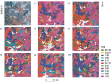
Fig. 9
Classification rendering of eCognition"

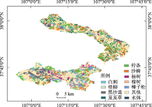
Fig. 10
Group E final classification results"

| [1] | 尼加提·卡斯木, 师庆东, 刘素红, 等. 基于卷积网络的沙漠腹地绿洲植物群落自动分类方法[J]. 农业机械学报, 2019, 50(1): 217-225. |
| [ Nijat Kasim, Shi Qingdong, Liu Suhong, et al. Automatic classification method of oasis plant community in desert hinterland based on VGGNet and ResNet models[J]. Transactions of the Chinese Society for Agricultural Machinery, 2019, 50(1): 217-225. ] | |
| [2] | 邬亚娟, 刘廷玺, 童新, 等. 基于面向对象的干旱半干旱地区植被分类[J]. 干旱区研究, 2020, 37(4): 1026-1034. |
| [ Wu Yajuan, Liu Tingxi, Tong Xin, et al. Vegetation classification in arid and semi-arid areas using an object-oriented method[J]. Arid Zone Research, 2020, 37(4): 1026-1034. ] | |
| [3] | 张贵花, 王瑞燕, 赵庚星, 等. 基于物候参数和面向对象法的濒海生态脆弱区植被遥感提取[J]. 农业工程学报, 2018, 34(4): 209-216. |
| [ Zhang Guihua, Wang Ruiyan, Zhao Gengxing, et al. Extraction of vegetation information in coastal ecological vulnerable areas from remote sensing data based on phenology parameters and object-oriented method[J]. Transactions of the Chinese Society of Agricultural Engineering, 2018, 34(4): 209-216. ] | |
| [4] | 刘润红, 梁士楚, 赵红艳, 等. 中国滨海湿地遥感研究进展[J]. 遥感技术与应用, 2017, 32(6): 998-1011. |
| [ Liu Runhong, Liang Shichu, Zhao Hongyan, et al. Progress of Chinese Coastal Wetland based on remote sensing[J]. Remote Sensing Technology and Application, 2017, 32(6): 998-1011. ] | |
| [5] | 陈仲新, 任建强, 唐华俊, 等. 农业遥感研究应用进展与展望[J]. 遥感学报, 2016, 20(5): 748-767. |
| [ Chen Zhongxin, Ren Jianqiang, Tang Huajun, et al. Progress and perspectives on agricultural remote sensing research and applications in China[J]. Journal of Remote Sensing, 2016, 20(5): 748-767. ] | |
| [6] |
Tang Lina, Shao Guofan. Drone remote sensing for forestry research and practices[J]. Journal of Forestry Research, 2015, 26(4): 791-797.
doi: 10.1007/s11676-015-0088-y |
| [7] | 王鹏, 万荣荣, 杨桂山. 基于多源遥感数据的湿地植物分类和生物量反演研究进展[J]. 湿地科学, 2017, 15(1): 114-124. |
| [ Wang Peng, Wan Rongrong, Yang Guishan. Advance in classification and biomass estimation of plants in wetlands based on multi-source remote sensing data[J]. Wetland Science, 2017, 15(1): 114-124. ] | |
| [8] |
徐凯健, 田庆久, 岳继博, 等. 基于多光谱影像的森林树种识别及其空间尺度响应[J]. 应用生态学报, 2018, 29(12): 3986-3994.
doi: 10.13287/j.1001-9332.201812.011 |
|
[ Xu Kaijian, Tian Qingjiu, Yue Jibo, et al. Forest tree species identification and its response to spatial scale based on multispectral and multi-resolution remotely sensed data[J]. Chinese Journal of Applied Ecology, 2018, 29(12): 3986-3994. ]
doi: 10.13287/j.1001-9332.201812.011 |
|
| [9] | Brewer C K, Barber J A, Willhauck G, et al. Multi-source and multi-classifier system for regional landcover mapping[J]. Advances in Techniques for Analysis of Remotely Sensed Data, 2003 : 143-149. |
| [10] | Bross L C. Using Landsat TM Imagery to Monitor Vegetation Change Following Flow Restoration to the Lower Owens River, California[D]. California: Portland State University, 2015. |
| [11] | 付伟, 徐涵秋, 王美雅, 等. 南方红壤典型水土流失区植被分类及植被类型变化的遥感评估——以福建省长汀县河田地区为例[J]. 遥感技术与应用, 2017, 32(3): 546-555. |
| [ Fu Wei, Xu Hanqiu, Wang Meiya, et al. Vegetation classification and variation assessment in a typical red soil erosion area in southern China: Hetian, changting country of Fujian Province[J]. Remote Sensing Technology and Application, 2017, 32(3): 546-555. ] | |
| [12] | 章晓洁, 邓艳芬, 张亚超, 等. 利用Sentinel-2A多光谱成像仪与Landsat 8陆地成像仪影像进行普陀山岛植被分类效果比较[J]. 测绘通报, 2019(10) : 97-100. |
| [ Zhang Xiaojie, Deng Yanfen, Zhang Yachao, et al. Comparison of vegetation classification performances on Putuoshan island using Sentinel-2A MSI and Landsat 8 OLI images[J]. Bulletin of Surveying and Mapping, 2019(10): 97-100. ] | |
| [13] | 朱永森, 曾永年, 张猛. 基于HJ卫星数据与面向对象分类的土地利用/覆盖信息提取[J]. 农业工程学报, 2017, 33(14): 258-265. |
| [ Zhu Yongsen, Zeng Yongnian, Zhang Meng. Extract of land use/cover information based on HJ satellites data and object-oriented classification[J]. Transactions of the Chinese Society of Agricultural Engineering, 2017, 33(14): 258-265. ] | |
| [14] | 张猛, 曾永年, 朱永森. 面向对象方法的时间序列MODIS数据湿地信息提取——以洞庭湖流域为例[J]. 遥感学报, 2017, 21(3): 479-492. |
| [ Zhang Meng, Zeng Yongnian, Zhu Yongsen. Wetland mapping of Donting Lake Basin based on time-series MODIS data and object-oriented method[J]. Journal of Remote Sensing, 2017, 21(3): 479-492. ] | |
| [15] | 马燕妮, 明冬萍, 杨海平. 面向对象影像多尺度分割最大异质性参数估计[J]. 遥感学报, 2017, 21(4): 566-578. |
| [ Ma Yanni, Ming Dongping, Yang Haiping. Scale estimation of object-oriented image analysis based on spectral-spatial statistics[J]. Journal of Remote Sensing, 2017, 21(4): 566-578. ] | |
| [16] |
任传帅, 叶回春, 崔贝, 等. 基于面向对象分类的芒果林遥感提取方法研究[J]. 资源科学, 2017, 39(8): 1584-1591.
doi: 10.18402/resci.2017.08.14 |
|
[ Ren Chuanshuai, Ye Huichun, Cui Bei, et al. Acreage estimation of mango orchards using object-oriented classification and remote sensing[J]. Resources Science, 2017, 39(8): 1584-1591. ]
doi: 10.18402/resci.2017.08.14 |
|
| [17] |
Douglas G, Goodin. Mapping land cover and land use from object-based classification: an example from a complex agricultural landscape[J]. International Journal of Remote Sensing, 2015, 36(18): 4702-4723.
doi: 10.1080/01431161.2015.1088674 |
| [18] | 向海燕, 罗红霞, 刘光鹏, 等. 基于Sentinel-1A极化SAR数据与面向对象方法的山区地表覆被分类[J]. 自然资源学报, 2017, 32(12): 2136-2148. |
| [ Xiang Haiyan, Luo Hongxia, Liu Guangpeng, et al. Land cover classification in mountain areas based on Sentinel-1A polarimetric SAR data and object oriented method[J]. Journal of Nature Resources, 2017, 32(12): 2136-2148. ] | |
| [19] | 姚金玺, 王浪, 李建忠, 等. 青海诺木洪地区多源遥感及多特征组合地物分类[J]. 农业工程学报, 2022, 38(3): 247-256. |
| [ Yao Jinxi, Wang Lang, Li Jianzhong, et al. Multi-source remote sensing and multi-feature combination ground object classification in Nuomuhong areas, Qinghai Province of China[J]. Transactions of the Chinese Society of Agricultural Engineering, 2022, 38(3): 247-256. ] | |
| [20] |
罗开盛. 基于面向对象技术的旅游用地遥感识别[J]. 中国科学院大学学报, 2020, 37(4): 490-497.
doi: 10.7523/j.issn.2095-6134.2020.04.008 |
|
[ Luo Kaisheng. Remote sensing identification of tourism land use based on object-oriented technology[J]. Journal of University of Chinese Academy of Sciences, 2020, 37(4): 490-497. ]
doi: 10.7523/j.issn.2095-6134.2020.04.008 |
|
| [21] | Iabchoon S, Wongsai S, Chankon K. Mapping urban impervious surface using object-based image analysis with WorldView-3 satellite imagery[J]. Journal of Applied Remote Sensing, 2017, 11: 046015. |
| [22] | 马梦茹, 张永彬, 王奕丹. 最佳波段选择的迁西县土地利用信息提取研究[J]. 华北理工大学学报(自然科学版), 2021, 43(3): 20-29. |
| [ Ma Mengru, Zhang Yongbin, Wang Yidan. Research on extraction of land utilization information of Qianxi County based on optimum band selection[J]. Journal of North China University of Seience and Technology(Natural Science Edition), 2021, 43(3): 20-29. ] | |
| [23] | 彭佳忆, 王新军, 朱磊, 等. 基于无人机影像的荒漠地表类型信息提取[J]. 干旱区研究, 2019, 36(3): 771-780. |
| [ Peng Jiayi, Wang Xinjun, Zhu Lei, et al. Information extraction of desert surface types based on UVA Image[J]. Arid Zone Research, 2019, 36(3): 771-780. ] | |
| [24] | 王芳, 杨武年, 王建, 等. 遥感影像多尺度分割中最优尺度的选取及评价[J]. 遥感技术与应用, 2020, 35(3): 623-633. |
| [ Wang Fang, Yang Wunian, Wang Jian, et al. Selection and evaluation of the optimal scale in multiscale segmentation of remote sensing images[J]. Remote Sensing Technology and Application, 2020, 35(3): 623-633. ] | |
| [25] | 陈喜梅, 王庆国, 王一斐, 等. eCognition在西藏全区草原普查遥感影像信息快速提取中的应用[J]. 中国草地学报, 2017, 39(2): 117-120. |
| [ Chen Ximei, Wang Qingguo, Wang Yifei, et al. Application of eCognition to rapidly extract the information form remote sensing image of grassland general investigation in Tibet region[J] .Chinese Journal of Grassland, 2017, 39(2): 117-120. ] | |
| [26] | 郑琪, 邸苏闯, 潘兴瑶, 等. 基于Rapid Eye数据的北京生态涵养区土地利用分类及变化研究[J]. 遥感技术与应用, 2020, 35(5): 1118-1126. |
| [ Zheng Qi, Di Suchuang, Pan Xingyao, et al. Study of land use classification and changes in the ecological conservation region of Beijing based on Rapid Eye images[J]. Remote Sensing Technology and Application, 2020, 35(5): 1118-1126. ] | |
| [27] | 袁磊, 赵俊三, 陈国平, 等. 面向对象的土地利用多尺度时空数据模型[J]. 测绘科学, 2014, 39(11): 52-56, 71. |
| [ Yuan Lei, Zhao Junsan, Chen Guoping, et al. An object-oriented multi-scale spatio-temporal data model for land-use[J]. Science of Surveying and Mapping, 2014, 39(11): 52-56, 71. ] | |
| [28] | 宋奇, 史舟, 冯春晖, 等. 基于1990—2019年多时相影像的干旱区绿洲景观格局分析[J]. 干旱区研究, 2022, 39(2): 594-604. |
| [ Song Qi, Shi Zhou, Feng Chunhui, et al. Analysis of landscape pattern from 1990 to 2019 based on multi-temporal imagery in arid oasis[J]. Arid Zone Research, 2022, 39(2): 594-604. ] |
| [1] | ZHAO Mingtao, WANG Chaoqun, LIANG Meiqi, HE Tonghui. Response of species diversity of typical submerged plant communities to sediment in Yinchuan Plain wetlands [J]. Arid Zone Research, 2023, 40(11): 1815-1823. |
| [2] | MENG Na, ZHANG Ying. Identification of priority areas for forest land expansion in Shanxi Province [J]. Arid Zone Research, 2023, 40(1): 111-122. |
| [3] | ZHOU Jing,YAN Cheng,GUO Ruizeng,YAN Ziyan. Plant community allocation modes of protection greenbelt in an arid gravel desert region [J]. Arid Zone Research, 2021, 38(3): 812-820. |
| [4] | ZHANG Peng,LI Ying,WANG Yelin,SONG Chengcheng,GAO Fanglei,XIE Lina,MA Chengcang. The positive effect of Caragana breviflora shrubs on plant communities and soil microbial communities in the Inner Mongolia desert region [J]. Arid Zone Research, 2021, 38(2): 421-428. |
| [5] | ZHAO Ling-di, FENG Jian, SUN Ling-xiao, YU Xiang, ZHAO Peng. Relationship between Water & Air Pollutant Emission and FDI in Arid Cities in Northwest China [J]. Arid Zone Research, 2020, 37(1): 67-73. |
| [6] | YANG Xiaodong,LV Guanghui,HE Xueming,LI Yan,ZHANG Xueni,WANG Xiyuan,LIU Weiguo. Variation of Soil Enzyme Activity among Four Typical Plant Communities in the Ebinur Lake Wetland Nature Reserve,Xinjiang [J]. , 2017, 34(6): 1278-1285. |
| [7] | JIANG Shi-gao,SHANG Zhen-yan, NIU De-cao,ZHANG Bao-lin,ZHANG Si-lian, FU Hua. Relationship between Grassland Plant Diversity and Foliar C∶N∶P Stoichiometry on the Western Slope of the Helan Mountain [J]. , 2014, 31(3): 523-529. |
| [8] | LI Cheng-Xiu, LI Xiao-Yan, YANG Tai-Bao, LI Yue-Tan-. Structure and Species Diversity of Meadow Community along the Shaliu River in the Qinghai Lake Basin [J]. , 2013, 30(6): 1028-1035. |
| [9] | ZHANG Juan-Hong, HE Tong-Hui, CHENG Zhi, ZHANG Yu-Feng. Factors Affecting the Diversity of Plant Communities on Ditch Slope in the Ningxia Plain [J]. , 2013, 30(5): 845-849. |
| [10] | LI Chang-Jun, 吕Guang-Hui , GONG Lu, ZHANG Hai-Feng, LIU Xiao-Xing. Spatial Point Pattern and Response of Clonal Plant Communities to High Drought and Salt Stress in the Ebinur Lake Wetland Nature Reserve, Xinjiang, China [J]. , 2013, 30(1): 122-128. |
| [11] | MA Yu-E, QIAN Yi-Bing, DUAN Shi-Min, CHANG Yi-Shen, LI Yang-Qi. Study on Vegetation Distribution and Species Diversity in the Ebinur Lake Basin [J]. , 2012, 29(5): 776-783. |
| [12] | YANG Fan, WANG Xue-Qin, YANG Dong-Liang, HAN Zhang-Yong, ZHENG Xin-Qian. [J]. , 2012, 29(5): 763-769. |
| [13] | ZENG Ya-juan,HAI Ying,CHEN Ji-ding,WANG Yun,YE Cheng-yin,PANG Ming,TAO Shuang-cheng,WANG Meng-meng. A Preliminary Report about Vegetation Investigated along the China-Pakistan Karakoram Highway [J]. , 2012, 29(1): 73-80. |
| [14] | CHANG Zhao-Feng, HAN Fu-Gui, ZHONG Sheng-Nian, CHAI Er-Wu. Study on the Phenological Characteristics of the Main Plant Species and the Use of Pastures in the Minqin Desert Areas [J]. , 2011, 27(1): 20-26. |
|
||