Arid Zone Research ›› 2025, Vol. 42 ›› Issue (2): 321-332.doi: 10.13866/j.azr.2025.02.12
• Ecology and Environment • Previous Articles Next Articles
LI Hao1,2( ), ZHANG Lei1,2, LIANG Xiaolei1,2, LIU Geng2,3()
Received:2024-08-29
Revised:2024-10-17
Online:2025-02-15
Published:2025-02-21
Contact:
LIU Geng
E-mail:lihao666@tynu.edu.cn;liugeng9696@126.com
LI Hao, ZHANG Lei, LIANG Xiaolei, LIU Geng. Ecological restoration zoning based on the GeoSOM network: A case study of the Shanxi section of the Yellow River Basin[J].Arid Zone Research, 2025, 42(2): 321-332.
Add to citation manager EndNote|Reference Manager|ProCite|BibTeX|RefWorks
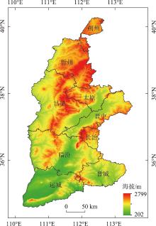
Fig. 1
Location of the study area"

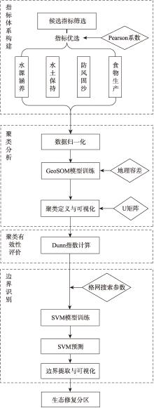
Fig. 2
Flow chart of the research"
Tab. 1
Ecological restoration zoning indicator system"
| 指标 | 计算模型 | 计算公式 | 参数解释 |
|---|---|---|---|
| 水源涵养 | 水量平衡方程[ | TQ为总水源涵养量(m3);Pi为降雨量(mm);Ri为地表径流量(mm);ETi为蒸散发(mm);Ai为i类生态系统面积(km2);i为研究区第i类生态系统类型;j为研究区生态系统类型数 | |
| 水土保持 | 修正后的土壤流失RUSLE方程[ | ||
| 防风固沙 | 估算潜在和实际风蚀强度模拟[ | ||
| 食物生产 | 农田生产潜力数据集[ | yieldtotal是由GAEZ模型计算的粮食总生产潜力;yieldirrigated和yieldrain-fed分别为灌溉和雨养条件下的粮食生产潜力; i为灌溉率,等于灌溉面积与总耕地面积的比率 |

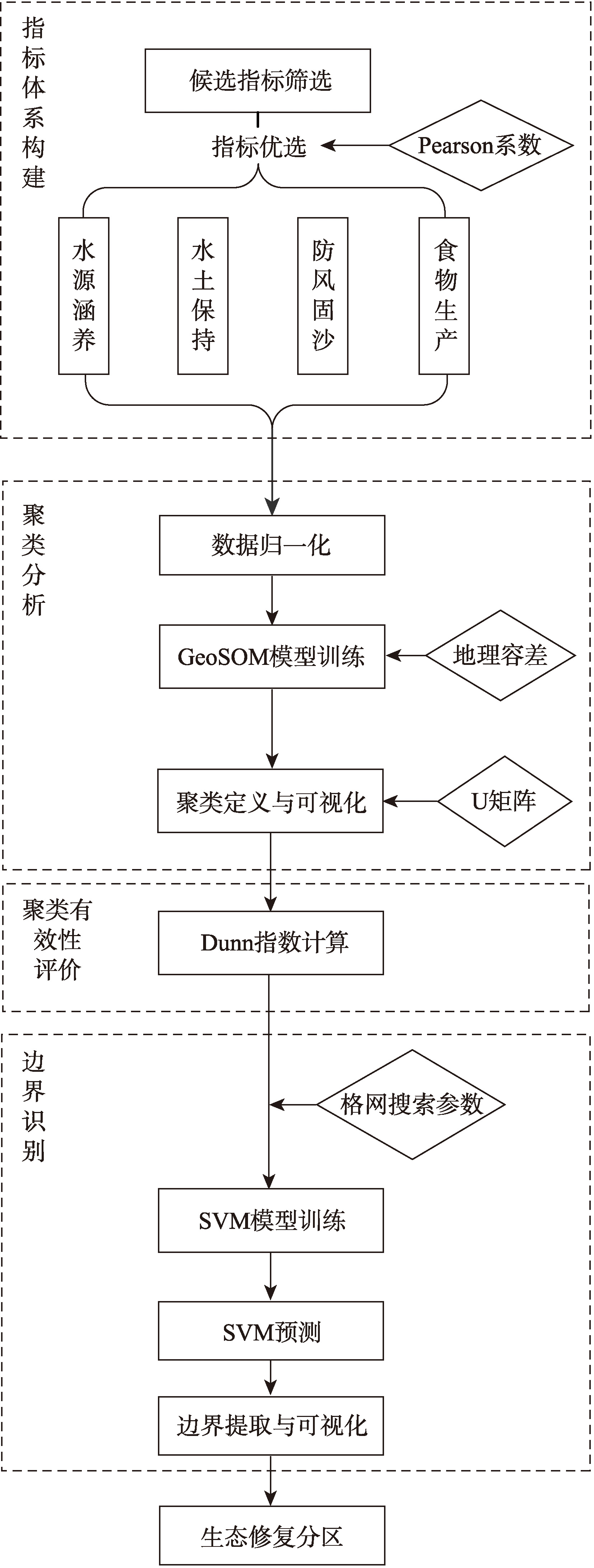
Fig. 3
GeosOM network structure"
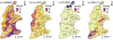
Fig. 4
Spatial distribution of single factors for ecological restoration in the Shanxi section of the Yellow River Basin"
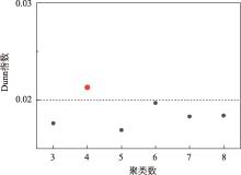
Fig. 5
Dunn index for different clustering schemes"
Fig. 6
GeoSOM clustering results map and radar chart of attributes for each category"
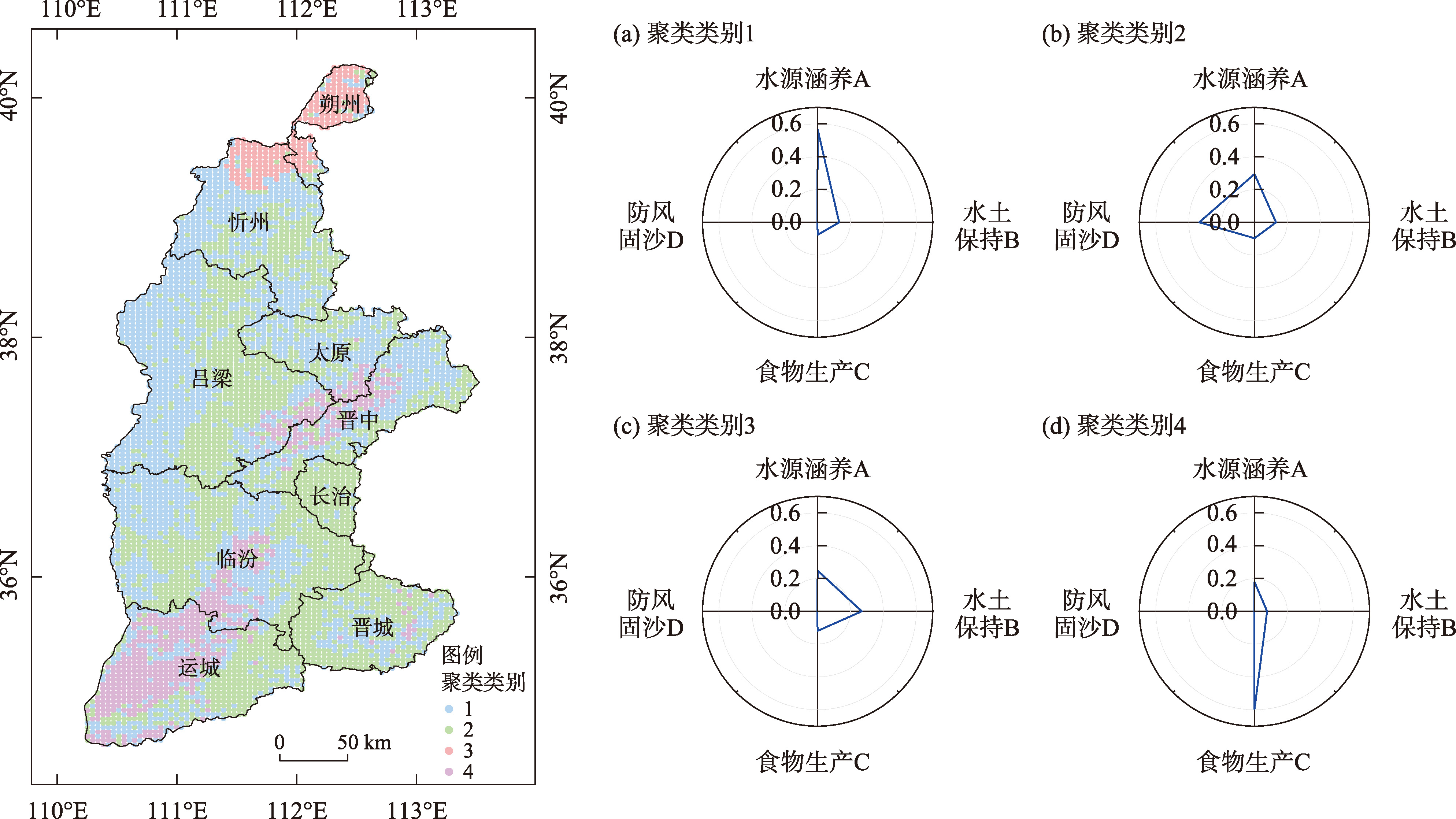
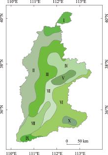
Fig. 7
Ecological restoration zoning in the Shanxi section of the Yellow River Basin"

| [1] |
吴绍洪, 高江波, 戴尔阜, 等. 中国陆地表层自然地域系统动态研究: 思路与方案[J]. 地球科学进展, 2017, 32(6): 569-576.
doi: 10.11867/j.issn.1001-8166.2017.06.0569 |
|
[Wu Shaohong, Gao Jiangbo, Dai Erfu, et al. Research on dynamic of terrestrial system of China: Academic logic and synthetic scheme[J]. Advances in Earth Science, 2017, 32(6): 569-576. ]
doi: 10.11867/j.issn.1001-8166.2017.06.0569 |
|
| [2] | 王韵秋, 胡业翠, 高梦雯, 等. 多维视角下广西喀斯特石漠化地区国土空间生态修复分区[J]. 农业工程学报, 2023, 39(1): 223-231. |
| [Wang Yunqiu, Hu Yecui, Gao Mengwen, et al. Ecological restoration zoning of land space in Karst rocky desertification areas of Guangxi from a multidimensional perspective[J]. Transactions of the Chinese Society of Agricultural Engineering, 2023, 39(1): 223-231. ] | |
| [3] |
包玉斌, 王耀宗, 路锋, 等. 六盘山区国土空间生态安全格局构建与分区优化[J]. 干旱区研究, 2023, 40(7): 1172-1183.
doi: 10.13866/j.azr.2023.07.14 |
|
[Bao Yubin, Wang Yaozong, Lu Feng, et al. Construction of an ecological security pattern and zoning optimization for territorial space in the Liupan Mountain Area[J]. Arid Zone Research, 2023, 40(7): 1172-1183. ]
doi: 10.13866/j.azr.2023.07.14 |
|
| [4] |
李可璇, 张蕾, 李豪, 等. 基于MSPA模型和电路理论的晋西北国土空间生态修复关键区域识别[J]. 干旱区研究, 2024, 41(9): 1593-1604.
doi: 10.13866/j.azr.2024.09.15 |
|
[Li Kexuan, Zhang Lei, Li Hao, et al. Identification of the key regions of spatial ecological restoration in the Northwest Shanxi based on the MSPA model and circuit theory[J]. Arid Zone Research, 2024, 41(9): 1593-1604. ]
doi: 10.13866/j.azr.2024.09.15 |
|
| [5] | 向爱盟, 岳启发, 赵筱青, 等. 国土空间生态修复关键区识别及修复分区——以西南喀斯特山区开远市为例[J]. 中国环境科学, 2023, 43(12): 6571-6582. |
| [Xiang Aimeng, Yue Qifa, Zhao Xiaoqing, et al. Identification of key areas and zoning for ecological restoration in land space: A case study of Kaiyuan City in the Southwest Karst Mountain Area[J]. China Environmental Science, 2023, 43(12): 6571-6582. ] | |
| [6] |
谢余初, 张素欣, 林冰, 等. 基于生态系统服务供需关系的广西县域国土生态修复空间分区[J]. 自然资源学报, 2020, 35(1): 217-229.
doi: 10.31497/zrzyxb.20200118 |
|
[Xie Yuchu, Zhang Suxin, Lin Bing, et al. Spatial zoning for land ecological restoration in Guangxi counties based on the supply and demand relationship of ecosystem services[J]. Journal of Natural Resources, 2020, 35(1): 217-229. ]
doi: 10.31497/zrzyxb.20200118 |
|
| [7] |
岳文泽, 侯丽, 夏皓轩, 等. 基于生态系统服务供需平衡的宁夏固原生态修复分区与优化策略[J]. 应用生态学报, 2022, 33(1): 149-158.
doi: 10.13287/j.1001-9332.202112.024 |
|
[Yue Wenze, Hou Li, Xia Haoxuan, et al. Ecological restoration zoning and optimization strategies in Guyuan, Ningxia based on the balance of ecosystem services supply and demand[J]. Chinese Journal of Applied Ecology, 2022, 33(1): 149-158. ]
doi: 10.13287/j.1001-9332.202112.024 |
|
| [8] |
张甜, 彭建, 刘焱序, 等. 基于植被动态的黄土高原生态地理分区[J]. 地理研究, 2015, 34(9): 1643-1661.
doi: 10.11821/dlyj201509004 |
| [Zhang Tian, Peng Jian, Liu Yanxu, et al. Ecogeographical zoning of the Loess Plateau based on vegetation dynamics[J]. Geographical Research, 2015, 34(9): 1643-1661. ] | |
| [9] | 郑度. 中国生态地理区域系统研究[M]. 北京: 科学出版社, 2008. |
| [Zheng Du. Research on China’s Ecological Geographical Regional System[M]. Beijing: Science Press, 2008. ] | |
| [10] | 杨勤业, 郑度, 吴绍洪. 中国的生态地域系统研究[J]. 自然科学进展, 2002, 12(3): 287-291. |
| [Yang Qinye, Zheng Du, Wu Shaohong. Research on China’s ecological regional system[J]. Advances in Natural Science, 2002, 12(3): 287-291. ] | |
| [11] | 张学儒, 张镱锂, 刘林山, 等. 基于SOFM神经网络模型的土地类型分区尝试——以青藏高原东部样带为例[J]. 地理研究, 2013, 32(5): 839-847. |
| [Zhang Xueru, Zhang Yili, Liu Linshan, et al. An attempt at land type zoning based on the SOFM neural network model: A case study of the eastern transect of the Tibetan Plateau[J]. Geographical Research, 2013, 32(5): 839-847. ] | |
| [12] | 李淑娟, 高琳. 胶州湾北岸滨海地区4个时期生态系统服务价值和生态功能区划分研究[J]. 湿地科学, 2020, 18(2): 129-140. |
| [Li Shujuan, Gao Lin. Study on the value of ecosystem services and zoning of ecological function areas in the northern coastal area of Jiaozhou Bay during four periods[J]. Wetland Science, 2020, 18(2): 129-140. ] | |
| [13] | 路昌, 雷国平, 周浩, 等. 基于两维图论聚类法的东北地区土地利用分区研究[J]. 农业机械学报, 2017, 48(12): 155-164. |
| [Lu Chang, Lei Guoping, Zhou Hao, et al. Study on land use zoning in Northeast China based on two-dimensional graph theory clustering method[J]. Transactions of the Chinese Society for Agricultural Machinery, 2017, 48(12): 155-164. ] | |
| [14] |
马程, 李双成, 刘金龙, 等. 基于SOFM网络的京津冀地区生态系统服务分区[J]. 地理科学进展, 2013, 32(9): 1383-1393.
doi: 10.11820/dlkxjz.2013.09.008 |
|
[Ma Cheng, Li Shuangcheng, Liu Jinlong, et al. Zoning of ecosystem services in the Beijing-Tianjin-Hebei region based on SOFM network[J]. Progress in Geography, 2013, 32(9): 1383-1393. ]
doi: 10.11820/dlkxjz.2013.09.008 |
|
| [15] | 邓敏. 空间聚类分析及应用[M]. 北京: 科学出版社, 2011. |
| [Deng Min. Spatial Clustering Analysis and Application[M]. Beijing: Science Press, 2011. ] | |
| [16] | 黄姣, 高阳, 赵志强, 等. 基于GIS与SOFM网络的中国综合自然区划[J]. 地理研究, 2011, 30(9): 1648-1659. |
| [Huang Jiao, Gao Yang, Zhao Zhiqiang, et al. Comprehensive natural regionalization of China based on GIS and SOFM Network[J]. Geographical Research, 2011, 30(9): 1648-1659. ] | |
| [17] | Bação F, Lobo V, Painho M. The self-organizing map, the Geo-SOM, and relevant variants for geosciences[J]. Computers & Geosciences, 2005, 31(2): 155-163. |
| [18] | Bação F, Lobo V S, Painho M. Applications of different self-organizing map variants to geographical information science problems[C]// Lisbon: International Cartographic Conference, 2008. |
| [19] |
彭建, 毛祺, 杜悦悦, 等. 中国自然地域分区研究前沿与挑战[J]. 地理科学进展, 2018, 37(1): 121-129.
doi: 10.18306/dlkxjz.2018.01.013 |
|
[Peng Jian, Mao Qi, Du Yueyue, et al. Frontiers and challenges in the study of China’s natural regionalization[J]. Progress in Geography, 2018, 37(1): 121-129. ]
doi: 10.18306/dlkxjz.2018.01.013 |
|
| [20] | Gao J, Li S, Zhao Z. Validating the demarcation of eco-geographical regions: A geostatistical application[J]. Environmental Earth Sciences, 2010, 59: 1327-1336. |
| [21] |
董玉祥, 徐茜, 杨忍, 等. 基于地理探测器的中国陆地热带北界探讨[J]. 地理学报, 2017, 72(1): 135-147.
doi: 10.11821/dlxb201701011 |
|
[Dong Yuxiang, Xu Qian, Yang Ren, et al. Discussion on the northern boundary of the tropical zone in China based on geographic detectors[J]. Acta Geographica Sinica, 2017, 72(1): 135-147. ]
doi: 10.11821/dlxb201701011 |
|
| [22] |
毛祺, 彭建, 刘焱序, 等. 耦合SOFM与SVM的生态功能分区方法——以鄂尔多斯市为例[J]. 地理学报, 2019, 74(3): 460-474.
doi: 10.11821/dlxb201903005 |
| [Mao Qi, Peng Jian, Liu Yanxu, et al. Ecological function zoning method coupling SOFM and SVM: A case study of Ordos City[J]. Acta Geographica Sinica, 2019, 74(3): 460-474. ] | |
| [23] |
付绍桐, 贺晨曦, 马佳凯, 等. 不同发展情景下黄河流域山西段生态环境质量[J]. 应用生态学报, 2024, 35(5): 1337-1346.
doi: 10.13287/j.1001-9332.202405.027 |
|
[Fu Shaotong, He Chenxi, Ma Jiakai, et al. Ecological environment quality in the Shanxi Section of the Yellow River Basin under different development scenarios[J]. Chinese Journal of Applied Ecology, 2024, 35(5): 1337-1346. ]
doi: 10.13287/j.1001-9332.202405.027 |
|
| [24] | 中华人民共和国国家发展和改革委员会, 中华人民共和国自然资源部. 全国重要生态系统保护和修复重大工程总体规划(2021—2035年)[EB/OL]. (2020-06-03)[2024-10-12]. https://www.gov.cn/zhengce/zhengceku/202 0-06/12/content_5518982.htm. |
| [National Development and Reform Commission of the People’s Republic of China, Ministry of Natural Resources of the People’s Republic of China. National major orojects for the protection and restoration of important ecosystems general plan (2021-2035)[EB/OL]. (2020-06-03)[2024-10-12]. https://www.gov.cn/zhengce/zhengceku/202 0-06/12/content_5518982.htm. ] | |
| [25] | 徐新良, 刘纪远, 张树文. 中国多时期土地利用遥感监测数据集(CNLUCC)[DB/OL]. http://www.resdc.cn/DOI.2018. |
| [Xu Xinliang, Liu Jiyuan, Zhang Shuwen. China multi-period land use remote sensing monitoring dataset (CNLUCC)[DB/OL]. http://www.resdc.cn/DOI.2018. ] | |
| [26] | 姜甜甜. 我国湖泊生态分区技术及应用研究[D]. 武汉: 武汉大学, 2014. |
| [Jiang Tiantian. Research on Lake Ecological Zoning Technology and Application in China[D]. Wuhan: Wuhan University, 2014. ] | |
| [27] | 赵娜倩. 山西省山水林田湖草生态保护修复试点区分区及管控研究[D]. 太原: 山西大学, 2019. |
| [Zhao Naqian. Zoning and Management of Ecological Protection and Restoration Pilot Areas in the Mountains, Forests, Rivers, Lakes, and Grasslands of Shanxi Province[D]. Taiyuan: Shanxi University, 2019. ] | |
| [28] | 丹宇卓, 彭建, 张子墨, 等. 基于“退化压力-供给状态-修复潜力”框架的国土空间生态修复分区——以珠江三角洲为例[J]. 生态学报, 2020, 40(23): 8451-8460. |
| [Dan Yuzhuo, Peng Jian, Zhang Zimo, et al. Zoning of land space ecological restoration based on the “Degradation Pressure-Supply Status-Restoration Potential” framework: A case study of the Pearl River Delta[J]. Acta Ecologica Sinica, 2020, 40(23): 8451-8460. ] | |
| [29] |
闫豫疆, 李建贵, 李均力, 等. 面向生态系统服务供需的开都-孔雀河流域生态安全格局研究[J]. 干旱区研究, 2023, 40(5): 829-839.
doi: 10.13866/j.azr.2023.05.15 |
| [Yan Yujian, Li Jiangui, Li Junli, et al. Ecological security pattern of the Kaidu-Kongque river basin oriented towards ecosystem services supply and demand[J]. Arid Zone Research, 2023, 40(5): 829-839. ] | |
| [30] | 郑仲帅. 县域生态空间动态识别,功能演变与分区管控[D]. 雅安: 四川农业大学, 2022. |
| [Zheng Zhongshuai. Dynamic Identification, Functional Evolution,and Zoning Management and Control of County-Level Ecological Space[D]. Ya’an: Sichuan Agricultural University, 2022. ] | |
| [31] | 徐新良, 蔡红艳. 中国农田生产潜力数据集[DB/OL]. 北京: 中国科学院地理科学与资源研究所, 2017. |
| [Xu Xinliang, Cai Hongyan. China’s farmland production potential dataset[DB/OL]. Beijing: Institute of Geographic Sciences and Natural Resources Research, Chinese Academy of Sciences, 2017. ] | |
| [32] |
杨亚东, 段丁丁, 巨章宏, 等. 基于FAO-GAEZ模型的中国马铃薯县域种植空间布局优化[J]. 地理研究, 2022, 41(12): 3352-3363.
doi: 10.11821/dlyj020211125 |
| [Yang Yadong, Duan Dingding, Ju Zhanghong, et al. Optimization analysis of China’s potato spatial layout at county level based on FAO-GAEZ model[J]. Geographical Research, 2022, 41(12): 3352-3363. ] | |
| [33] | Henriques R, Bação F, Lobo V. GeoSOM Suite: A tool for spatial clustering[C]//Proceedings of the Computational Science and Its Applications-ICCSA 2009:International Conference, Seoul, Korea, June 29-July 2, 2009, Proceedings, Part I. Springer, 2009. |
| [34] | 刘燕驰, 高学东, 国宏伟, 等. 聚类有效性的组合评价方法[J]. 计算机工程与应用, 2011, 47(19): 15-17, 30. |
| [Liu Yanchi, Gao Xuedong, Guo Hongwei, et al. A combined evaluation method for clustering validity[J]. Computer Engineering and Applications, 2011, 47(19): 15-17, 30. ] | |
| [35] |
Brereton R G, Lloyd G R. Support vector machines for classification and regression[J]. Analyst, 2010, 135(2): 230-267.
doi: 10.1039/b918972f pmid: 20098757 |
| [36] | Bação F, Lobo V, Painho M. Geo-self-organizing map (Geo-SOM) for building and exploring homogeneous regions[C]// Springer: Proceedings of the International Conference on Geographic Information Science, 2004. |
| [37] | 吕一河. 生态学中的尺度及尺度转换方法[J]. 生态学报, 2001, 21(12): 2096-2105. |
| [Lü Yihe. Scale and scale conversion methods in ecology[J]. Acta Ecologica Sinica, 2001, 21(12): 2096-2105. ] | |
| [38] | 丁世飞, 齐丙娟, 谭红艳. 支持向量机理论与算法研究综述[J]. 电子科技大学学报, 2011, 40(1): 9-12. |
| [Ding Shifei, Qi Bingjuan, Tan Hongyan. A review of support vector machine theory and algorithms[J]. Journal of the University of Electronic Science and Technology of China, 2011, 40(1): 9-12. ] | |
| [39] | 丁世飞. 孪生支持向量机:理论、 算法与拓展[M]. 北京: 清华大学出版社, 2017. |
| [Ding Shifei. Twin Support Vector Machines:Theory, Algorithms, and Extensions[M]. Beijing: Tsinghua University Press, 2017. ] | |
| [40] | 山西省人民政府. 山西省主体功能区规划[EB/OL]. (2022-05-13)[2024-10-12]. https://www.shanxi.gov.cn/zfxxgk/zfxxgkzl/fdzdgknr/lzyj/szfwj/202205/t20220513_5976013.shtml. |
| [The People’s Government of Shanxi Province. Shanxi Province’s main functional area planning[EB/OL]. (2022-05-13)[2024-10-12]. https://www.shanxi.gov.cn/zfxxgk/zfxxgkzl/fdzdgknr/lzyj/szfwj/202205/t20220513_5976013.shtml. | |
| [41] | 赵乾坤. 山西省水土保持功能分区及生态脆弱性评价[D]. 泰安: 山东农业大学, 2014. |
| [Zhao Qiankun. Zoning of Soil and Water Conservation Functions and Evaluation of Ecological Vulnerability in Shanxi Province[D]. Tai’an: Shandong Agricultural University, 2014. ] |
| [1] | XU Mingjing, FENG Qiang, LYU Meng. Tradeoffs of ecosystem services and their influencing factors: A case study of the Shanxi Section of the Yellow River Basin [J]. Arid Zone Research, 2024, 41(3): 467-479. |
|
||