Arid Zone Research ›› 2024, Vol. 41 ›› Issue (3): 363-374.doi: 10.13866/j.azr.2024.03.02
• Weather and Climate • Previous Articles Next Articles
WANG Xueying1,2( ), GU Huanghe1,2(), DAI Bin3, ZHANG Hanwen3, YU Zhongbo1,2
Received:2023-10-18
Revised:2023-12-24
Online:2024-03-15
Published:2024-04-01
WANG Xueying, GU Huanghe, DAI Bin, ZHANG Hanwen, YU Zhongbo. Simulation of climate characteristics in the Qinghai-Tibet Plateau by regional climate models at different horizontal resolutions[J].Arid Zone Research, 2024, 41(3): 363-374.
Add to citation manager EndNote|Reference Manager|ProCite|BibTeX|RefWorks
Tab. 1
The design scheme of the test"
| RegCM | WRF | |
|---|---|---|
| 水平分辨率 | 10 km、25 km、50 km | 10 km、25 km、50 km |
| 经纬度范围 | 70 °~106 °E, 23 °~42 °N; 49 °~180 °E, 0 °~61 °N; 33 °E~180 °E, 24 °S~67 °N | 74 °~106 °E, 22 °~42 °N; 50 °~180 °E, 0 °~49 °N; 40 °E~180 °E, 24 °S~65 °N |
| 格点数 | 297×189、394×249、 243×197 | 277×216、395×250、 233×197 |
| 对流参数化方案 | MIT-Emanuel | Kain-Fritch Ⅱ |
| 陆面参数化方案 | CLM 3.5 | NOAH LSM |
| 行星边界层 | Hotslag | YSU |
| 谱逼近方法 | 选用 | 选用 |
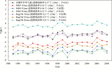
Fig. 1
The annual average temperature on the Qinghai-Tibet Plateau simulated by WRF and RegCM at different horizontal resolutions"

Tab. 2
Error analysis of annual and seasonal temperature in Qinghai-Tibet Plateau based on the simulation results"
| 年均 | 春季 | 夏季 | 秋季 | 冬季 | ||
|---|---|---|---|---|---|---|
| RegCM模式10 km | MAE/℃ | 0.33 | 2.17 | 0.69 | 0.80 | 0.82 |
| RMSE/℃ | 0.44 | 2.27 | 0.79 | 1.00 | 1.04 | |
| R | 0.55 | 0.47 | 0.65 | 0.47 | 0.55 | |
| WRF模式10 km | MAE/℃ | 1.77 | 3.38 | 0.27 | 2.20 | 1.41 |
| RMSE/℃ | 1.78 | 3.40 | 0.34 | 2.24 | 1.47 | |
| R | 0.91 | 0.87 | 0.71 | 0.73 | 0.93 | |
| RegCM模式25 km | MAE/℃ | 2.45 | 4.20 | 2.80 | 1.67 | 1.14 |
| RMSE/℃ | 2.48 | 4.24 | 2.86 | 1.83 | 1.29 | |
| R | 0.75 | 0.67 | 0.50 | 0.19 | 0.81 | |
| WRF模式25 km | MAE/℃ | 3.37 | 5.65 | 1.54 | 2.40 | 3.92 |
| RMSE/℃ | 3.38 | 5.65 | 1.55 | 2.43 | 3.95 | |
| R | 0.93 | 0.96 | 0.92 | 0.84 | 0.91 | |
| RegCM模式50 km | MAE/℃ | 2.13 | 0.96 | 2.06 | 3.44 | 2.42 |
| RMSE/℃ | 2.15 | 1.00 | 2.07 | 3.47 | 2.82 | |
| R | 0.93 | 0.89 | 0.87 | 0.15 | 0.70 | |
| WRF模式50 km | MAE/℃ | 3.77 | 6.20 | 2.39 | 2.91 | 3.74 |
| RMSE/℃ | 3.79 | 6.24 | 2.41 | 2.95 | 3.86 | |
| R | 0.72 | 0.73 | 0.79 | 0.01 | 0.63 |

Fig. 2
The annual precipitation on the Qinghai-Tibet Plateau simulated by WRF model and RegCM model at different horizontal resolutions"

Tab. 3
Error analysis of annual and seasonal precipitation in Qinghai-Tibet Plateau based on the simulation results"
| 年均 | 春季 | 夏季 | 秋季 | 冬季 | ||
|---|---|---|---|---|---|---|
| RegCM模式10 km | BIAS/% | 75 | 102 | 22 | 126 | 532 |
| MAE/mm | 290.7 | 70.6 | 49.3 | 98.3 | 73.3 | |
| RMSE/mm | 293.1 | 72.2 | 55.3 | 99.0 | 74.5 | |
| R | 0.69 | 0.28 | 0.60 | 0.48 | 0.62 | |
| WRF模式10 km | BIAS/% | 50 | 101 | 15 | 55 | 342 |
| MAE/mm | 195.4 | 69.9 | 35.4 | 42.5 | 47.2 | |
| RMSE/mm | 201.3 | 71.2 | 43.0 | 44.5 | 47.7 | |
| R | 0.37 | 0.08 | 0.63 | 0.03 | 0.50 | |
| RegCM模式25 km | BIAS/% | 125 | 210 | 68 | 123 | 640 |
| MAE/mm | 486.0 | 145.9 | 156.4 | 96.1 | 88.1 | |
| RMSE/mm | 489.5 | 146.8 | 161.1 | 97.2 | 88.5 | |
| R | -0.08 | 0.09 | -0.05 | 0.03 | 0.57 | |
| WRF模式25 km | BIAS/% | 134 | 151 | 113 | 139 | 365 |
| MAE/mm | 523.0 | 104.9 | 259.0 | 108.2 | 50.3 | |
| RMSE/mm | 524.6 | 105.4 | 261.1 | 108.9 | 51.0 | |
| R | 0.73 | 0.65 | 0.80 | 0.55 | 0.21 | |
| RegCM模式50 km | BIAS/% | 169 | 246 | 122 | 165 | 565 |
| MAE/mm | 658.8 | 170.5 | 279.5 | 128.4 | 77.9 | |
| RMSE/mm | 659.5 | 170.8 | 280.1 | 129.3 | 79.8 | |
| R | 0.83 | 0.76 | 0.83 | 0.52 | 0.29 | |
| WRF模式50 km | BIAS/% | 51 | 60 | 42 | 51 | 135 |
| MAE/mm | 197.2 | 41.6 | 95.4 | 40.1 | 18.5 | |
| RMSE/mm | 204.2 | 44.3 | 99.1 | 42.2 | 20.4 | |
| R | 0.28 | 0.05 | 0.57 | 0.45 | 0.19 |
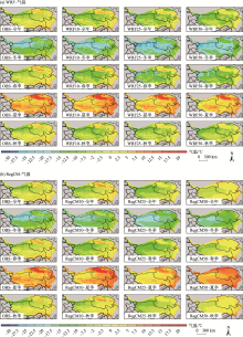
Fig. 3
Spatial distribution map of the annual average and seasonal temperature on the Qinghai-Tibet Plateau simulated by WRF model (a) and RegCM model (b) at different horizontal resolutions"

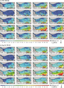
Fig. 4
Spatial distribution map of the annual and seasonal precipitation on the Qinghai-Tibet Plateau simulated by WRF model (a) and RegCM model (b) at different horizontal resolutions"

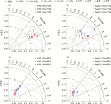
Fig. 5
Taylor analysis diagram of seasonal temperature (a, b), seasonal precipitation (c, d) simulated by WRF model and RegCM model at different horizontal resolutions"

Fig. 6
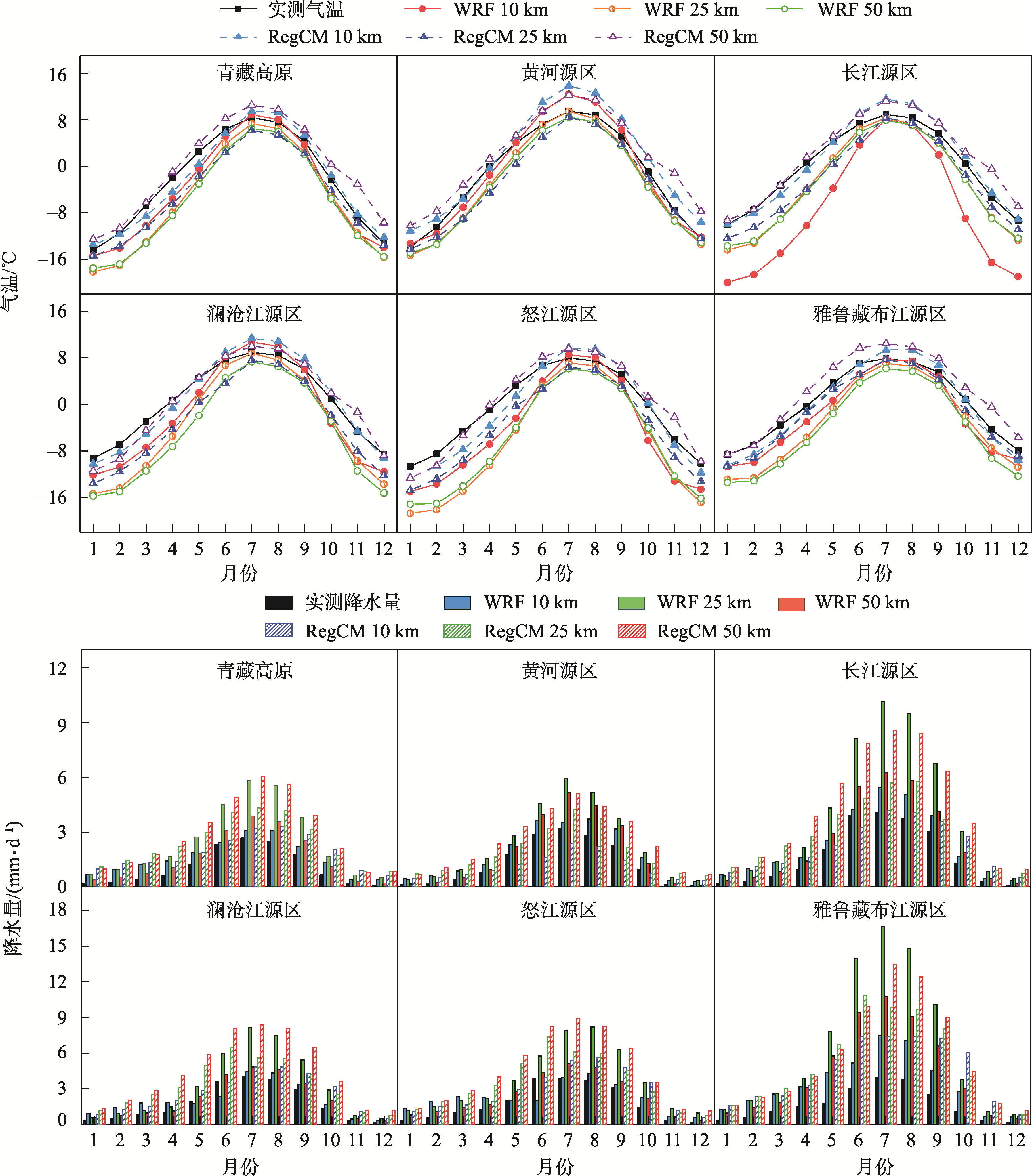
Annual monthly mean temperature (top) and annual monthly mean precipitation (bottom) in the five source rivers of Qinghai-Tibet Plateau simulated by WRF model and RegCM model at different horizontal resolutions"
| [1] | Duan A, Wu G. Change of cloud amount and the climate warming on the Tibetan Plateau[J]. Geophysical Research Letters, 2006, 33(22): 217-234. |
| [2] | 杨昭明, 张调风. 1961—2017年青藏高原东北部雨季降水量变化及其贡献度分析[J]. 干旱区研究, 2021, 38(1): 22-28. |
| [Yang Zhaoming, Zhang Tiaofeng. Analysis of precipitation change and its contribution in the rainy season in the northeast Qinghai-Tibet Plateau from 1961 to 2017[J]. Arid Zone Research, 2021, 38(1): 22-28.] | |
| [3] |
Liu X, Chen B. Climatic warming in the Tibetan Plateau during recent decades[J]. International Journal of Climatology, 2000, 20(14): 1729-1742.
doi: 10.1002/(ISSN)1097-0088 |
| [4] |
杨耀先, 胡泽勇, 路富全, 等. 青藏高原近60年来气候变化及其环境影响研究进展[J]. 高原气象, 2022, 41(1): 1-10.
doi: 10.7522/j.issn.1000-0534.2021.00117 |
|
[Yang Yaoxian, Hu Zeyong, Lu Fuquan, et al. Progress of recent 60 years’ climate change and its environmental impacts on the Qinghai-Xizang Plateau[J]. Plateau Meteorology, 2022, 41(1): 1-10.]
doi: 10.7522/j.issn.1000-0534.2021.00117 |
|
| [5] | Wang A, Zeng X. Evaluation of multireanalysis products with in situ observations over the Tibetan Plateau[J]. Journal of Geophysical Research: Atmospheres, 2012, 117(D5): 2011JD016553. |
| [6] |
Giorgi F, Gutowski W J. Regional dynamical downscaling and the CORDEX initiative[J]. Annual Review of Environment and Resources, 2015, 40: 467-490.
doi: 10.1146/energy.2015.40.issue-1 |
| [7] |
Gao X, Giorgi F. Use of the RegCM system over east Asia: Review and Perspectives[J]. Engineering, 2017, 3(5): 766-772.
doi: 10.1016/J.ENG.2017.05.019 |
| [8] | 王澄海, 余莲. 区域气候模式对不同的积云参数化方案在青藏高原地区气候模拟中的敏感性研究[J]. 大气科学, 2011, 35(6): 1132. |
| [Wang Chenghai, Yu Lian. Sensitivity of regional climate model to different cumulus parameterization schemes in simulation of the Tibetan Plateau climate[J]. Chinese Journal of Atmospheric Sciences, 2011, 35(6): 1132-1144.] | |
| [9] |
吴遥, 李跃清, 蒋兴文, 等. WRF模拟青藏高原东南部极端旱涝年降水的参数敏感性研究[J]. 高原气象, 2017, 36(3): 619-631.
doi: 10.7522/j.issn.1000-0534.2016.00057 |
|
[Wu Yao, Li Yueqing, Jiang Xingwen, et al. Parameters sensitivity analysis on simulation of rainfall in drought-flood year on Qinghai-Tibetan Plateau by WRF model[J]. Plateau Meteorology, 2017, 36(3): 619-631.]
doi: 10.7522/j.issn.1000-0534.2016.00057 |
|
| [10] | 吕光辉, 于恩涛, 向伟玲, 等. WRF模式分辨率对新疆异常降雨天气要素模拟的影响[J]. 气候与环境研究, 2009, 14(1): 85-96. |
| [Lü Guanghui, Yu Entao, Xiang Weiling, et al. Effect of horizontal and vertical resolution on WRF simulation of the unusual rainfall event in Xinjiang[J]. Climatic and Environmental Research, 2009, 14(1): 85-96.] | |
| [11] | 刘金波, 曾新民, 郑益群. 区域气候模式分辨率对中国夏季气温模拟影响的评估[J]. 气象学报, 2011, 69(3): 534-543. |
| [Liu Jinbo, Zeng Xinmin, Zheng Yiqun. An assessment of the effects of the resolution of a regional climate model on simulated summer temperatures in China[J]. Acta Meteorologica Sinica, 2011, 69(3): 534-543.] | |
| [12] |
Xuan Q, Qian X, Yao Y, et al. Validation of the WRF model for estimating precipitable water vapor at the Ali observatory on the Tibetan Plateau[J]. Publications of the Astronomical Society of the Pacific, 2020, 132(1018): 125003.
doi: 10.1088/1538-3873/abc22d |
| [13] | 张芳华, 马旭林, 杨克明. 2003年6月24—25日江南特大暴雨数值模拟和诊断分析[J]. 气象, 2004, 30(1): 28-33. |
| [Zhang Fanghua, Ma Xulin, Yang Keming. Numerical simulation and diagnostic analysis of a heavy rainfall in Jiangnan area during 24-25 June 2003[J]. Meteorological Monthly, 2004, 30(1): 28-33.] | |
| [14] | 何由, 阳坤, 姚檀栋, 等. 基于WRF模式对青藏高原一次强降水的模拟[J]. 高原气象, 2012, 31(5): 1183-1191. |
| [He You, Yang Kun, Yao Tandong, et al. Numerical simulation of a heavy precipitation in Qinghai-Xizang Plateau based on WRF model[J]. Plateau Meteorology, 2012, 31(5): 1183.] | |
| [15] |
Gao Y H, Xu J W, Chen D L, et al. Evaluation of WRF mesoscale climate simulations over the Tibetan Plateau during 1979-2011[J]. Journal of Climate, 2015, 28: 2823-2841.
doi: 10.1175/JCLI-D-14-00300.1 |
| [16] | 梁玲, 李跃清, 胡豪然, 等. RegCM3模式对青藏高原温度和降水的模拟及检验[J]. 气象科学, 2009, 29(5): 611-617. |
| [Liang Ling, Li Yueqing, Hu Haoran, et al. Simulation of air temperature and precipitation over Qinghai-Xizang Plateau with RegCM3 model[J]. Journal of the Meteorological Sciences, 2009, 29(5): 611-617.] | |
| [17] |
韩振宇, 高学杰, 徐影. 多区域模式集合的东亚陆地区域的平均和极端降水未来预估[J]. 地球物理学报, 2021, 64(6): 1869-1884.
doi: 10.6038/cjg2021O0103 |
| [Han Zhenyu, Gao Xuejie, Xu Ying. Mean and extreme precipitation projection over land area of East Asia based on multiple regional climate models[J]. Chinese Journal of Geophysics, 2021, 64(6): 1869-1884.] | |
| [18] |
Gu H, Yu Z, Peltier W R, et al. Sensitivity studies and comprehensive evaluation of RegCM4.6.1 high-resolution climate simulations over the Tibetan Plateau[J]. Climate Dynamics, 2020, 54(7-8): 3781-3801.
doi: 10.1007/s00382-020-05205-6 |
| [19] |
He J, Yang K, Tang W, et al. The first high-resolution meteorological forcing dataset for land process studies over China[J]. Scientific Data, 2020, 7: 25.
doi: 10.1038/s41597-020-0369-y pmid: 31964891 |
| [20] |
Yang K, He J, Tang W J, et al. On downward shortwave and longwave radiations over high altitude regions: Observation and modeling in the Tibetan Plateau[J]. Agricultural and Forest Meteorology, 2010, 150: 38-46.
doi: 10.1016/j.agrformet.2009.08.004 |
| [21] | 阳坤, 何杰, 唐文君, 等. 中国区域地面气象要素驱动数据集(1979-2018)[DB/OL]. 国家青藏高原科学数据中心, 2019. https://doi.org/10.11888/AtmosphericPhysics.tpe.249369.file. |
| [Yang Kun, He Jie, Tang Wenjun, et al. China meteorological forcing dataset (1979-2018)[DB/OL]. National Tibetan Plateau/ Third Pole Environment Data Center, 2019. https://doi.org/10.11888/AtmosphericPhysics.tpe.249369.file.] | |
| [22] | 温婷婷, 郭英香, 董少睿, 等. 1979—2017年CRU、ERA5、CMFD格点降水数据在青藏高原适用性评估[J]. 干旱区研究, 2022, 39(3): 684-697. |
| [Wen Tingting, Guo Yingxiang, Dong Shaorui, et al. Assessment of CRU, ERA5, CMFD grid precipitation data for the Tibetan Plateau from 1979 to 2017[J]. Arid Zone Research, 2022, 39(3): 684-697.] | |
| [23] | 吴阳. 夏季青藏高原湖泊群区域气候效应及其作用机理的数值模拟研究[D]. 南京: 南京大学, 2018. |
| [Wu Yang. Numerical Study of the Regional Climate Effect of Lake Clusters in Tibetan Plateau and Its Working Mechanisms during Summer[D]. Nanjing: Nanjing University, 2008.] | |
| [24] |
Taylor K E. Summarizing multiple aspects of model performance in a single diagram[J]. Journal of Geophysical Research: Atmospheres, 2001, 106(D7): 7183-7192.
doi: 10.1029/2000JD900719 |
| [25] | 胡清静. 甘肃省1959-2006年气候及主要河流径流特征分析[D]. 兰州: 兰州大学, 2011. |
| [Hu Qingjing. Characteristic of Climate and Runoff of Main Rivers in Gansu during 1959-2006[D]. Lanzhou: Lanzhou University, 2011.] | |
| [26] | 胡芩, 姜大膀, 范广洲. CMIP5全球气候模式对青藏高原地区气候模拟能力评估[J]. 大气科学, 2014, 38(5): 924-938. |
| [Hu Qin, Jiang Dabang, Fan Guangzhou. Evaluation of CMIP5 models over the Qinghai-Tibetan Plateau[J]. Chinese Journal of Atmospheric Sciences, 2014, 38(5): 924-938.] | |
| [27] |
New M, Hulme M, Jones P. Representing twentieth-century space-time climate variability. Part I: Development of a 1961-90 mean monthly terrestrial climatology[J]. Journal of Climate, 1999, 12(3): 829-856.
doi: 10.1175/1520-0442(1999)012<0829:RTCSTC>2.0.CO;2 |
| [28] |
Rahimi S R, Wu C, Liu X, et al. Exploring a variable-resolution approach for simulating regional climate over the Tibetan Plateau using VR-CESM[J]. Journal of Geophysical Research: Atmospheres, 2019, 124(8): 4490-4513.
doi: 10.1029/2018JD028925 |
| [29] |
Ou T, Chen D, Chen X, et al. Simulation of summer precipitation diurnal cycles over the Tibetan Plateau at the gray-zone grid spacing for cumulus parameterization[J]. Climate Dynamics, 2020, 54: 3525-3539.
doi: 10.1007/s00382-020-05181-x |
| [30] |
Fu Y, Ma Y, Zhong L, et al. Land-surface processes and summer-cloud-precipitation characteristics in the Tibetan Plateau and their effects on downstream weather: A review and perspective[J]. National Science Review, 2020, 7(3): 500-515.
doi: 10.1093/nsr/nwz226 pmid: 34692070 |
| [31] | Zhao D, Lin Y, Dong W, et al. Alleviated WRF summer wet bias over the Tibetan Plateau using a new cloud macrophysics scheme[J]. Journal of Advances in Modeling Earth Systems, 2023, 15(10): e2023MS003616. |
| [32] | 熊喆, 宋长青. 对流解析区域气候模式对青藏高原降水模拟能力的研究[J]. 北京师范大学学报(自然科学版), 2022, 58(2): 337-347. |
| [Xiong Zhe, Song Changqing. Convection-permitting regional climate model to simulate precipitation in the Qinghai-Tibet Plateau[J]. Journal of Beijing Normal University (Natural Science), 2022, 58(2): 337-347.] | |
| [33] | 高艳红, 许建伟, 张萌, 等. 青藏高原气候动力降尺度——从1/4度到公里尺度[J]. 中国科学: 地球科学, 2022, 32(12): 2342-2352. |
| [Gao Yanhong, Xu Jianwei, Zhang Meng, et al. Regional climate dynamical downscaling over the Tibetan Plateau—From quarter-degree to kilometer-scale[J]. Scientia Sinica (Terrae), 2022, 32(12): 2237-2247.] |
| [1] | ZHAO Lichao, ZHANG Chengfu, HE Shuai, MIAO Lin, FENG Shuang, PAN Sihan. Simulation of land surface temperature in complex mountainous terrain and the influence of environmental factors: A case study in Daqingshan, Inner Mongolia [J]. Arid Zone Research, 2024, 41(5): 765-775. |
| [2] | GUAN Yuqi, LI Guang, PAN Xue, XU Guorong, WEI Xingxing, LIU Hao, WU Jiangqi. Effects of changing rainfall frequency on the soil carbon, nitrogen, and phosphorus ecostochimetrics in the Gahai wet meadow, Gannan [J]. Arid Zone Research, 2023, 40(6): 916-925. |
| [3] | YANG Zhaoming,ZHANG Tiaofeng. Analysis of precipitation change and its contribution in the rainy season in the northeast Qinghai-Tibet Plateau from 1961 to 2017 [J]. Arid Zone Research, 2021, 38(1): 22-28. |
| [4] | WEI Qian,LONG Xiao,ZHAO Jianhua,HAN Zifei,WANG Siyi. Impact of boundary layer parameterization schemes on the simulation of a dust event over Northwest China [J]. Arid Zone Research, 2021, 38(1): 163-177. |
| [5] | DING Ming-yue, WANG Li-li, XIN Yu, LIU Qiong, CHEN Yong-hang, ZHANG Guang-xin, YANG Lian-mei, LIANG Qian, HUANG Guan, LIU Tong-qiang. Diagnostic analysis and numerical simulation of a Central Asian vortex rainstorm based on CloudSat satellite data [J]. Arid Zone Research, 2020, 37(4): 936-946. |
| [6] | DING Ming-yue, WANG Li-li, XIN Yu, CHEN Yong-hang, YANG Lian-mei, LIANG Qian, LIU Qiong, LIU Tong-qiang. TS Score of WRF Cloud Microphysical Parameterization Scheme to the Simulation Capability of Precipitation in Xinjiang [J]. Arid Zone Research, 2019, 36(6): 1411-1418. |
| [7] | LI Yan-ping, SHI Li-jiang, XU Man-hou, LI Wen-gang. Effect of Short-Term Warming on Dynamic Change of Soil Moisture Content in Growing Season in the Permafrost Regions of the Qinghai-Tibet Plateau [J]. Arid Zone Research, 2019, 36(3): 537-545. |
| [8] | ZHANG Ying, HUANG Xiao-Dong, Wang-Wei, LIANG Tian-Gang. Validation and Algorithm Redevelopment of MODIS Daily Fractional Snow Cover Products [J]. , 2013, 30(5): 808-814. |
| [9] | LI Lin, YANG Xiu-Hai, ZHA Xi-Yang-Zong, ZHAO Wen, LA Ba-Zhuo-Ma. Change of the Lakes in the Qiangtang Nature Reserve [J]. , 2013, 30(3): 419-423. |
| [10] | HOU Guang-Liang, ZHANG Xue-Lian, XIAO Jing-Yi, E Chong-Yi. Human Migration and Diffusion in Northeastern Margin of the Qinghai-Tibet Plateau since the Late Glacial Period [J]. , 2013, 30(1): 149-155. |
| [11] | DU Liang-Liang, LI Jiang-Ping, CHEN Xiao-Yan, SHANG Ke-Zheng, YANG De-Bao, WANG Shi-Gong. Analysis on Cloud and Vapor Flux in the Northeast of the Qinghai-Tibet Plateau during the Period from 2001 to 2011 [J]. , 2012, 29(5): 862-869. |
| [12] | HAN Jun-Cai, ZHOU Shun-Wu, WU Ping, WANG Chuan-Hui, YANG Shuang-Yan, YANG Ming. Spatial Distribution of Water Vapor Content over the Qinghai-Tibet Plateau in Summer [J]. , 2012, 29(3): 457-463. |
| [13] | LI Xin-Zhou, LIU Xiao-Dong. A Modeling Study on Drought Trend in the Sino-Mongolian Arid and Semiarid Regions in the 21st Century [J]. , 2012, 29(2): 262-272. |
| [14] | JIA Li-Hong, TANG Hao, WANG Jiang, ZHANG Yun-Hui. Experimental Study on Ensemble Forecast in Forecasting Heavy Rainfall in Xinjiang [J]. , 2011, 28(5): 891-895. |
|
||