干旱区研究 ›› 2022, Vol. 39 ›› Issue (2): 388-399.doi: 10.13866/j.azr.2022.02.06 cstr: 32277.14.AZR.20220206
梁洪武1( ),阿里木江·卡斯木1,2(),赵禾苗1,赵永玉1
收稿日期:2021-08-21
修回日期:2021-10-08
出版日期:2022-03-15
发布日期:2022-03-30
作者简介:梁洪武(1998-),男,硕士研究生,研究方向为城市热环境研究. E-mail: 基金资助:
LIANG Hongwu1(),Alimujiang Kasim1,2(),ZHAO Hemiao1,ZHAO Yongyu1
Received:2021-08-21
Revised:2021-10-08
Published:2022-03-15
Online:2022-03-30
摘要:
城市化的加快推进使得土地利用变化加剧,进而导致城市热环境问题日益突出。基于2005年和2018年夏季的MYD21A2地表温度数据,运用空间统计学方法分析了LST的时空分布格局,并结合土地利用数据,通过贡献度指数,对天山北坡城市群地表覆盖类型和行政区划的源汇角色特征进行了分析。结果表明:(1) 2005—2018年建设用地、耕地增长显著,冰川、林地等自然资源地类显著减少,说明城市的发展对生态环境和自然资源造成了较为严重的影响。(2) 地表温度等级的空间分布与海拔呈负相关关系,2005—2018年高温度等级在白天的空间分布有离散化趋势,而夜间则相反,夜间高温度等级空间分布整体有向东南迁移的趋势。(3) 不同城市、不同地表覆盖类型由于自然条件、比热容等物理性质的不同,其白天和夜间源汇角色不同,可归纳为昼夜热源型(CI>0)、昼汇夜源型(白天CI<0,夜间CI>0)和昼夜热汇型(CI<0)。(4) 天山北坡城市群独特的气候和荒漠—绿洲—山地地貌致使建设用地为昼汇夜源型地类,源汇角色与内地一些城市群(京津冀城市群)存在差异。
梁洪武,阿里木江·卡斯木,赵禾苗,赵永玉. 天山北坡城市群地表温度时空差异及贡献度分析[J]. 干旱区研究, 2022, 39(2): 388-399.
LIANG Hongwu,Alimujiang Kasim,ZHAO Hemiao,ZHAO Yongyu. Analysis of the spatial and temporal differences in surface temperature and the contribution of surface coverage in the urban agglomeration on the northern slope of the Tianshan Mountains[J]. Arid Zone Research, 2022, 39(2): 388-399.
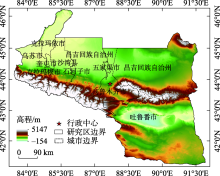
图1
研究区示意图"

表1
地表温度等级划分"
| 地表温度等级 | 划分依据 |
|---|---|
| 特高温 | T > μ+1.5std |
| 高温 | μ+0.5std<T≤ μ+1.5std |
| 中温 | μ-0.5std≤T< μ+0.5std |
| 低温 | μ-1.5std≤T< μ-0.5std |
| 极低温 | T< μ-1.5std |
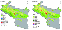
图2
2005年和2018年天山北坡城市群土地利用/覆盖空间分布"

表2
2005―2018年土地利用/覆盖类型面积变化统计"
| 土地利用/ 覆盖类型 | 2005年 | 2018年 | 2005—2018年 | |||||
|---|---|---|---|---|---|---|---|---|
| 面积/km2 | 比例/% | 面积/km2 | 比例/% | 变化面积/km2 | 变化比例/% | |||
| 草地 | 61282.23 | 31.60 | 59078.08 | 30.46 | -2204.15 | -3.60 | ||
| 耕地 | 16432.88 | 8.47 | 22543.51 | 11.62 | 6110.63 | 37.19 | ||
| 建设用地 | 1817.92 | 0.94 | 3229.49 | 1.67 | 1411.57 | 77.65 | ||
| 林地 | 5170.72 | 2.66 | 2596.93 | 1.34 | -2573.79 | -49.78 | ||
| 水域 | 669.43 | 0.35 | 896.31 | 0.46 | 226.88 | 33.89 | ||
| 冰川 | 2680.10 | 1.38 | 930.84 | 0.48 | -1749.26 | -65.27 | ||
| 未利用地 | 105883.03 | 54.60 | 104661.15 | 53.97 | -1221.88 | -1.15 | ||
表3
2005年和2018年白天、夜间LST等级面积统计"
| LST等级 | 面积/km2 | |||||
|---|---|---|---|---|---|---|
| 2005年白天 | 2018年白天 | 变化面积 | 2005年夜间 | 2018年夜间 | 变化面积 | |
| 极低温 | 21853.26 | 21523.25 | -330.01 | 17775.39 | 17728.24 | -50.15 |
| 低温 | 24798.27 | 30648.69 | 5850.42 | 16863.40 | 17758.23 | 894.83 |
| 中温 | 71828.66 | 63396.24 | -8432.42 | 113127.42 | 107471.98 | -5655.44 |
| 高温 | 73024.61 | 75945.86 | 2921.25 | 39567.02 | 43291.56 | 3724.54 |
| 特高温 | 2431.51 | 2422.27 | -9.24 | 6603.08 | 7689.30 | 1086.22 |
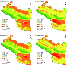
图3
2005年和2018年白天、夜间LST等级空间分布"

表4
地表温度全局空间自相关显著性检验"
| 时相 | Moran’s I | Z | P |
|---|---|---|---|
| 2005年白天 | 0.959 | 164.846 | <0.001 |
| 2005年夜间 | 0.954 | 164.607 | <0.001 |
| 2018年白天 | 0.958 | 158.944 | <0.001 |
| 2018年夜间 | 0.956 | 165.761 | <0.001 |

图4
地表温度局部空间自相关分布"

表5
高温度等级标准差椭圆参数信息"
| 时相 | 方向性 | 离散性 | 中心点坐标(经度) | 中心点坐标(纬度) | 方位角度/(°) |
|---|---|---|---|---|---|
| 2005年白天 | 2.22 | 130.99 | 89°38′E | 43°07′N | 133.58 |
| 2005年夜间 | 2.28 | 113.67 | 87°47′E | 44°34′N | 125.13 |
| 2018年白天 | 2.19 | 139.42 | 89°19′E | 43°12′N | 129.32 |
| 2018年夜间 | 2.60 | 112.76 | 88°01′E | 43°79′N | 124.54 |
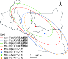
图5
高温度等级标准差椭圆的空间分布特征"


图6
各土地利用/覆盖类型白天、夜间的贡献度指数"
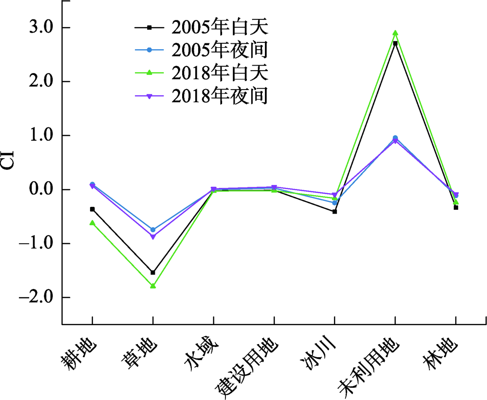
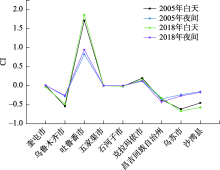
图7
白天、夜间不同城市贡献度指数"

| [1] | 李召良, 段四波, 唐伯惠, 等. 热红外地表温度遥感反演方法研究进展[J]. 遥感学报, 2016, 20(5):899-920. |
| [ Li Zhaoliang, Duan Sibo, Tang Bohui, et al. Review of methods for land surface temperature derived from thermal infrared remotely sensed data[J]. National Remote Sensing Bulletin, 2016, 20(5):899-920. ] | |
| [2] |
Deng Y H, Wang S J, Bai X Y, et al. Relationship among land surface temperature and LUCC, NDVI in typical karst area[J]. Scientific Reports, 2018, 8(1):641.
doi: 10.1038/s41598-017-19088-x |
| [3] | 满元伟, 李净, 邢立亭. 基于多源遥感数据的温度-土壤湿度-降水干旱指数(TMPDI)的构建与应用[J]. 干旱区研究, 2021, 38(5):1442-1451. |
| [ Man Yuanwei, Li Jing, Xing Liting. Development and application of the temperature soil moisture precipitation drought index (TMPDI) based on multi-source remote sensing data[J]. Arid Zone Research, 2021, 38(5):1442-1451. ] | |
| [4] | 匡文慧, 迟文峰, 陆灯盛, 等. 城市地表热环境遥感分析与生态调控[M]. 北京: 科学出版社, 2015. |
| [ Kuang Wenhui, Chi Wenfeng, Lu Dengsheng, et al. Remote Sensing-Based Analysis of Thermal Environment and Ecological Regulations in Cities[M]. Beijing: Science Press, 2015. ] | |
| [5] |
Fang C L, Gao Q, Zhang X L, et al. Spatiotemporal characteristics of the expansion of an urban agglomeration and its effect on the eco-environment: Case study on the northern slope of the Tianshan Mountains[J]. Science China Earth Sciences, 2019, 62(9):1461-1472.
doi: 10.1007/s11430-018-9369-x |
| [6] |
Liu J Y, Kuang W H, Zhang Z X, et al. Spatiotemporal characteristics, patterns, and causes of land-use changes in China since the late 1980s[J]. Journal of Geographical Sciences, 2014, 24(2):195-210.
doi: 10.1007/s11442-014-1082-6 |
| [7] | 尹昌应, 石忆邵, 王贺封, 等. 城市地表形态对热环境的影响——以上海市为例[J]. 长江流域资源与环境, 2015, 24(1):97-105. |
| [ Yin Changying, Shi Yishao, Wang Hefeng, et al. Impacts of urban landscape form on thermal environment at multi-spatial levels[J]. Resources and Environment in the Yangtze Basin, 2015, 24(1):97-105. ] | |
| [8] |
匡文慧. 城市土地利用/覆盖变化与热环境生态调控研究进展与展望[J]. 地理科学, 2018, 38(10):1643-1652.
doi: 10.13249/j.cnki.sgs.2018.10.008 |
|
[ Kuang Wenhui. Advance and future prospects of urban land use/cover change and ecological regulation of thermal environment[J]. Scientia Geographica Sinica, 2018, 38(10):1643-1652. ]
doi: 10.13249/j.cnki.sgs.2018.10.008 |
|
| [9] |
Cao Q, Yu D Y, Georgescu M, et al. Impacts of future urban expansion on summer climate and heat-related human health in eastern China[J]. Environment International, 2018, 112:134-146.
doi: 10.1016/j.envint.2017.12.027 |
| [10] |
谢启姣, 胡道华, 王贺封. 武汉城市扩张对热场时空演变的影响[J]. 地理研究, 2016, 35(7):1259-1272.
doi: 10.11821/dlyj201607004 |
|
[ Xie Qijiao, Liu Jinhua, Hua Daohua. Urban expansion and its impact on spatio-temporal variation of urban thermal characteristics: A case study of Wuhan[J]. Geographical Research, 2016, 35(7):1259-1272. ]
doi: 10.11821/dlyj201607004 |
|
| [11] | 杨丽萍, 刘晶, 潘雪萍, 等. 基于Landsat-8影像的西安市地表温度遥感反演与影响因子研究[J]. 兰州大学学报(自然科学版), 2019, 55(3):311-318. |
| [ Yang Liping, Liu Jing, Pan Xueping, et al. Land surface temperature retrieval and influential factor analysis in Xi’an based on Landsat 8 image[J]. Journal of Lanzhou University (Natural Sciences), 2019, 55(3):311-318. ] | |
| [12] | 买买提江·买提尼亚孜, 阿里木江·卡斯木. 干旱区典型城市下垫面特征及其与地表热环境的关系研究[J]. 生态环境学报, 2015, 24(11):1865-1871. |
| [ Maimaitijiang Maitiniyazi, Alimujiang Kasimu. Study on land surface characteristics and its relationship with land surface thermal environment of typical city in arid region[J]. Ecology and Environmental Sciences, 2015, 24(11):1865-1871. ] | |
| [13] | 周玄德, 郭华东, 孜比布拉·司马义. 城市扩张过程中不透水面空间格局演变及其对地表温度的影响———以乌鲁木齐市为例[J]. 生态学报, 2018, 38(20):7336-7347. |
| [ Zhou Xuande, Guo Huadong, Zibibula Simayi. Spatial pattern evolution of impervious surfaces and its influence on surface temperature in the process of urban expansion: A case study of Urumqi[J]. Acta Ecologica Sinica, 2018, 38(20):7336-7347. ] | |
| [14] |
Kuang W H, Dou Y Y, Zhang C, et al. Quantifying the heat flux regulation of metropolitan land use/land cover components by coupling remote sensing modeling with in situ measurement[J]. Journal of Geophysical Research Atmospheres, 2015, 120(1):113-130.
doi: 10.1002/2014JD022249 |
| [15] | 杨朝斌, 张亭, 胡长涛, 等. 蓝绿空间冷岛效应时空变化及其影响因素——以苏州市为例[J]. 长江流域资源与环境, 2021, 30(3):677-688. |
| [ Yang Chaobin, Zhang Ting, Hu Changtao, et al. Spatial-temporal characteristics of the cooling island for blue-green space and its driving factors in Suzhou, China[J]. Resources and Environment in the Yangtze Basin, 2021, 30(3):677-688. ] | |
| [16] | 周雯, 曹福亮, 张瑞, 等. 绿地格局对城市地表热环境调节作用的多尺度分析[J]. 南京林业大学学报(自然科学版), 2020, 44(3):133-141. |
| [ Zhou Wen, Cao Fuliang, Zhang Rui, et al. Multi-scale analysis of the effects of green space pattern on the urban surface thermal environment[J]. Journal of Nanjing Forestry University (Natural Sciences Edition), 2020, 44(3):133-141. ] | |
| [17] | 石蕾洁, 赵牡丹. 城市公园夏季冷岛效应及其影响因素研究——以西安市中心城区为例[J]. 干旱区资源与环境, 2020, 34(5):154-161. |
| [ Shi Leijie, Zhao Mudan. Cool island effect of urban parks and impact factors in summer: A case study of Xi’an[J]. Journal of Arid Land Resources and Environment, 2020, 34(5):154-161. ] | |
| [18] | 王雪, 于德永, 曹茜, 等. 城市景观格局与地表温度的定量关系分析[J]. 北京师范大学学报(自然科学版), 2017, 53(3):329-336. |
| [ Wang Xue, Yu Deyong, Cao Qian, et al. Quantitative relationship between urban landscape pattern and surface temperature[J]. Journal of Beijing Normal University (Natural Science), 2017, 53(3):329-336. ] | |
| [19] |
Lu L L, Weng Q H, Xiao D, et al. Spatiotemporal variation of surface urban heat islands in relation to land cover composition and configuration: A multi-scale case study of Xi’an, China[J]. Remote Sensing, 2020, 12(17):2713-2732.
doi: 10.3390/rs12172713 |
| [20] | 方创琳. 天山北坡城市群可持续发展战略思路与空间布局[J]. 干旱区地理, 2019, 42(1):1-11. |
| [ Fang Chuanglin. Strategic thinking and spatial layout for the sustainable development of urban agglomeration in northern slope of Tianshan Mountains[J]. Arid Land Geography, 2019, 42(1):1-11. ] | |
| [21] | 张丽芳, 方创琳, 高倩. 天山北坡城市群城市景观时空扩张过程及多情景模拟[J]. 生态学报, 2021, 41(4):1267-1279. |
| [ Zhang Lifang, Fang Chuanglin, Gao Qian. Spatial and temporal expansion of urban landscape and multi-scene simulation of urban agglomeration in northern slope of Tianshan Mountains[J]. Acta Ecologica Sinica, 2021, 41(4):1267-1279. ] | |
| [22] | 刘亚茹, 李莉, 菊春燕. 天山北坡城市群土地利用及生态服务价值时空演变[J]. 水土保持通报, 2020, 40(6):312-320. |
| [ Liu Yaru, Li Li, Ju Chunyan. Spatio-temporal evolution of land use and ecological service value in urban agglomeration on northern slope of Tianshan Mountains[J]. Bulletin of Soil and Water Conservation, 2020, 40(6):312-320. ] | |
| [23] | 杨倩, 秦莉, 高培, 等. 基于EEMD-LSTM模型的天山北坡经济带年降水量预测[J]. 干旱区研究, 2021, 38(5):1235-1243. |
| [ Yang Qian, Qin Li, Gao Pei, et al. Prediction of annual precipitation in the northern slope economic belt of Tianshan Mountains based on a EEMD-LSTM model[J]. 2021, 38(5):1235-1243. ] | |
| [24] | 胡李发, 谢元礼, 崔思颖, 等. 关中平原城市群夏季城市热岛特征及驱动力[J]. 中国环境科学, 2021, 41(8):3842-3852. |
| [ Hu Lifa, Xie Yuanli, Cui Siying, et al. Characteristics and driving forces analysis of urban heat island in Guanzhong Plain urban agglomeration in summer[J]. China Environmental Science, 2021, 41(8):3842-3852. ] | |
| [25] |
Li H, Li R B, Yang Y K, et al. Temperature-based and radiance-based validation of the collection 6 MYD11 and MYD21 land surface temperature products over barren surfaces in northwestern China[J]. IEEE Transactions on Geoscience and Remote Sensing, 2021, 59(2):1794-1807.
doi: 10.1109/TGRS.36 |
| [26] | 哈尚辰, 阿里木江·卡斯木. 基于土地集约利用水平的城市热岛效应影响因子分析[J]. 冰川冻土, 2016, 38(1):270-278. |
| [ Ha Shangchen, Kasimu Alimujiang. Analysis of the impact factors of urban heat island effect based on the intensive land use level[J]. Journal of Glaciology and Geocryology, 2016, 38(1):270-278. ] | |
| [27] |
赵璐, 赵作权. 基于特征椭圆的中国经济空间分异研究[J]. 地理科学, 2014, 34(8):979-986.
doi: 10.13249/j.cnki.sgs.2014.08.979 |
|
[ Zhao Lu, Zhao Zuoquan. Projecting the spatial variation of economic based on the specific ellipses in China[J]. Scientia Geographica Sinica, 2014, 34(8):979-986. ]
doi: 10.13249/j.cnki.sgs.2014.08.979 |
|
| [28] | 夏晓圣, 汪军红, 宋伟东, 等. 2000—2019年中国PM2.5时空演化特征[J]. 环境科学, 2020, 41(11):4832-4843. |
| [ Xia Xiaosheng, Wang Junhong, Song Weidong, et al. Spatio-temporal evolution of PM2.5 concentration during 2000-2019 in China[J]. Environmental Science, 2020, 41(11):4832-4843. ] | |
| [29] | 沈中健, 曾坚. 1996—2017年闽三角城市群区域热岛时空格局演化分析[J]. 安全与环境学报, 2020, 20(4):1567-1578. |
| [ Shen Zhongjian, Zeng Jian. Analysis of spatiotemporal patterns and evolution of regional thermal islands in Fujian delta urban agglomeration during decade of 1996-207[J]. Journal of Safety and Environmen, 2020, 20(4):1567-1578. ] | |
| [30] |
于琛, 胡德勇, 曹诗颂, 等. 近30年北京市ISP-LST空间特征及其变化[J]. 地理研究, 2019, 38(9):2346-2356.
doi: 10.11821/dlyj020180621 |
|
[ Yu Chen, Hu Deyong, Cao Shisong, et al. The spatial characteristics and changes of ISP-LST of Beijing in recent 30 years[J]. Geographical Research, 2019, 38(9):2346-2356. ]
doi: 10.11821/dlyj020180621 |
|
| [31] | 王戈, 于强, YANG Di, 等. 京津冀城市群生态空间格局变化与地表温度关系研究[J]. 农业机械学报, 2021, 52(1):209-218. |
| [ Wang Ge, Yu Qiang, Yang Di, et al. Relationship between change of ecological spatial pattern and land surface temperature in Beijing Tianjin Hebei Urban Agglomeration[J]. Transactions of the Chinese Society for Agricultural Machinery, 2021, 52(1):209-218. ] | |
| [32] | 宁秀红, 郭龙, 张海涛. 基于空间自回归和地理加权回归模型的不同尺度下土地利用程度研究[J]. 华中农业大学学报, 2013, 32(4):48-54. |
| [ Ning Xiuhong, Guo Long, Zhang Haitao. Comprehensive degree of land-use at different scales based on spatial autocorrelation regression and geographically weighted regression models[J]. Journal of Huazhong Agricultural University, 2013, 32(4):48-54. ] | |
| [33] | 孙宗耀, 孙希华, 徐新良, 等. 土地利用差异与变化对区域热环境贡献研究——以京津冀城市群为例[J]. 生态环境学报, 2018, 27(7):1313-1322. |
| [ Sun Zongyao, Sun Xihua, Xu Xinliang, et al. Study on the contribution of land use heterogeneity and change to regional thermal environment: A case study of Beijing-Tianjin-Hebei urban agglomeration[J]. Ecology and Environmental Sciences, 2018, 27(7):1313-1322. ] | |
| [34] |
Yu Z W, Yao Y W, Yang G Y, et al. Spatiotemporal patterns and characteristics of remotely sensed region heat islands during the rapid urbanization (1995-2015) of southern China[J]. Science of the Total Environment, 2019, 674(5):242-254.
doi: 10.1016/j.scitotenv.2019.04.088 |
| [35] |
Wang P Y, Li Z Q, Li H L, et al. Glaciers in Xinjiang, China: Past changes and current status[J]. Water, 2020, 12(9):2367-2381.
doi: 10.3390/w12092367 |
| [36] | 肖中琪, 黄建文, 凌成星. 新疆天山西部天然林保护工程区林地及森林生物量空间变化分析[J]. 林业资源管理, 2018, 47(1):57-62, 89. |
| [ Xiao Zhongqi, Huang Jianwen, Ling Chengxing. Spatial change analysis of forest land and biomass in natural forest protection project area of western Tianshan Mountain[J]. Forest Resources Management, 2018, 47(1):57-62, 89. ] | |
| [37] | 王靖淘. 基于遥感与GIS的土地利用景观格局变化研究[D]. 西安: 西安科技大学, 2018. |
| [ Wang Jingtao. Study on Land Use Landscape Pattern Change Based on Remote Sensing and GIS[D]. Xi’an: Xi’an University of Science and Technology, 2018. ] | |
| [38] |
Qiao Z, Tian G J, Xiao L. Diurnal and seasonal impacts of urbanization on the urban thermal environment: A case study of Beijing using MODIS data[J]. ISPRS Journal of Photogrammetry and Remote Sensing, 2013, 85:93-101.
doi: 10.1016/j.isprsjprs.2013.08.010 |
| [39] | 李润林, 时永杰, 姚艳敏, 等. 基于LandsatTM/ETM+的张掖市甘州区绿洲冷岛效应时空变化研究[J]. 干旱区资源与环境, 2014, 28(9):139-144. |
| [ Li Runlin, Shi Yongjie, Yao Yanmin, et al. Temporal and spatial variation of oasis cold island effect in Ganzhou district of Zhangye based on Landsat TM/ETM+[J]. Journal of Arid Land Resources and Environment, 2014, 28(9):139-144. ] | |
| [40] | 孙帆, 王弋, 陈亚宁. 塔里木盆地荒漠-绿洲过渡带动态变化及其影响因素[J]. 生态学杂志, 2020, 39(10):3397-3407. |
| [ Sun Fan, Wang Yi, Chen Yaning. Dynamics of desert-oasis ecotone and its influencing factors in Tarim Basin[J]. Chinese Journal of Ecology, 2020, 39(10):3397-3407. ] |
| [1] | 赵立超, 张成福, 贺帅, 苗林, 冯霜, 潘思涵. 复杂山区地表温度模拟及影响——以内蒙古大青山为例[J]. 干旱区研究, 2024, 41(5): 765-775. |
| [2] | 杨雅青, 张翀, 张婕, 王玉丹. 关中地区土壤干湿变化及对气候的响应[J]. 干旱区研究, 2024, 41(2): 261-271. |
| [3] | 李永广, 苑广辉. 青海湖流域不同下垫面类型对地表温度的生物物理影响[J]. 干旱区研究, 2024, 41(1): 24-35. |
| [4] | 李永康,王新军,马燕飞,胡贵锋,桂海月,张冠宏. 基于Catboost的AMSR-2半经验地表温度降尺度[J]. 干旱区研究, 2021, 38(6): 1637-1649. |
| [5] | 杨昭明,张调风. 1961—2017年青藏高原东北部雨季降水量变化及其贡献度分析[J]. 干旱区研究, 2021, 38(1): 22-28. |
| [6] | 赵美亮,曹广超,曹生奎,刘富刚,袁杰,张卓,刁二龙,付建新. 1980—2017年青海省地表温度时空变化特征[J]. 干旱区研究, 2021, 38(1): 178-187. |
| [7] | 韩军彩, 周顺武, 吴萍, 王传辉, 杨双艳, 杨明. 青藏高原上空夏季水汽含量的时空分布特征[J]. 干旱区研究, 2012, 29(3): 457-463. |
| [8] | 刘明春, 李玲萍. 石羊河流域地表0 cm温度的长期变化[J]. 干旱区研究, 2011, 28(3): 478-484. |
|
||