干旱区研究 ›› 2024, Vol. 41 ›› Issue (1): 135-146.doi: 10.13866/j.azr.2024.01.13 cstr: 32277.14.AZR.20240113
魏晋铭( ),程建军(),马奔腾
收稿日期:2023-08-17
修回日期:2023-09-21
出版日期:2024-01-15
发布日期:2024-01-24
作者简介:魏晋铭(1998-),男,硕士研究生,主要从事公路风沙防治. E-mail: 基金资助:
WEI Jinming(),CHENG Jianjun(),MA Benteng
Received:2023-08-17
Revised:2023-09-21
Published:2024-01-15
Online:2024-01-24
摘要:
为了摸清在建图木舒克—昆玉沙漠公路沿线的风沙环境特征,根据沙漠公路沿线风沙要素特征有针对性地进行风沙防护工程实践,采用现场踏勘、结合ERA5风速数据以及卫星影像数据,对图木舒克—昆玉沙漠公路沿线风沙活动规律进行分析。结果表明:公路沿线年平均风速在3.03~3.28 m·s-1,年均起沙风速在5.85~6.10 m·s-1,年起沙风频率在16.87%~21.41%。起沙风集中处在春、夏季,4—8月是一年中起沙风频率最高的月份,公路沿线以偏东风(NE,ENE,E,ESE)为主,麻扎塔格山以南偏西起沙风频高于以北。沿线年输沙势(DP)在99.77~145.30 VU,属低风能环境,中变率。麻扎塔格山南北两侧沙丘体积、密度差异明显,沿线沙丘移动速率在1.19~3.69 m·a-1,为中等移动速度,沙丘移动速率与沙丘垂直投影面积大小存在明显的负相关关系,移动方向范围在171.76°~192.53°,与合成输沙方向(RDD)基本吻合。麻扎塔格山以北防沙体系的设计以东侧为主,以南则要东西兼顾。
魏晋铭, 程建军, 马奔腾. 塔里木盆地西部图木舒克—昆玉沙漠公路沿线风沙环境特征[J]. 干旱区研究, 2024, 41(1): 135-146.
WEI Jinming, CHENG Jianjun, MA Benteng. Characteristics of the wind-sand environment along the Tumshuk-Kunyu Desert Highway in the western Tarim Basin[J]. Arid Zone Research, 2024, 41(1): 135-146.
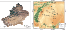
图1
公路位置示意图 注:底图采用自然资源部标准地图制作,审图号为GS(2019)3266号,对底图边界无修改。下同。"

表1
卫星影像具体日期"
| 研究区 | 影像日期/年-月-日 | 研究区 | 影像日期/年-月-日 |
|---|---|---|---|
| 1 | 2008-10-08 | 4 | 2013-03-20 |
| 2019-12-14 | 2016-04-23 | ||
| 2 | 2008-10-08 | 5 | 2013-01-21 |
| 2016-06-07 | 2016-04-23 | ||
| 3 | 2016-06-07 | 6 | 2012-09-22 |
| 2022-04-06 | 2019-12-26 |
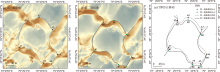
图2
计算沙丘移动 注:点A1~A7与点B1~B7分别表示图(a)与图(b)中沙丘的特征点位置,图(c)中特征点之间的连线为各对应特征点移动的方向与距离。"

表2
各研究区风况"
| 平均风速/(m·s-1) | 平均起沙风速/(m·s-1) | 最大风速/(m·s-1) | 起沙风主风向 | 起沙风频率 | |
|---|---|---|---|---|---|
| 1号研究区 | 3.09 | 5.85 | 12.51 | NE | 18.35% |
| 2号研究区 | 3.26 | 6.10 | 13.45 | NE | 20.00% |
| 3号研究区 | 3.18 | 6.06 | 13.85 | ENE | 18.60% |
| 4号研究区 | 3.28 | 5.98 | 18.71 | ENE | 21.41% |
| 5号研究区 | 3.28 | 5.96 | 18.56 | E | 21.01% |
| 6号研究区 | 3.03 | 5.91 | 12.72 | E | 16.87% |
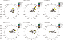
图3
各研究区起沙风风频玫瑰图"
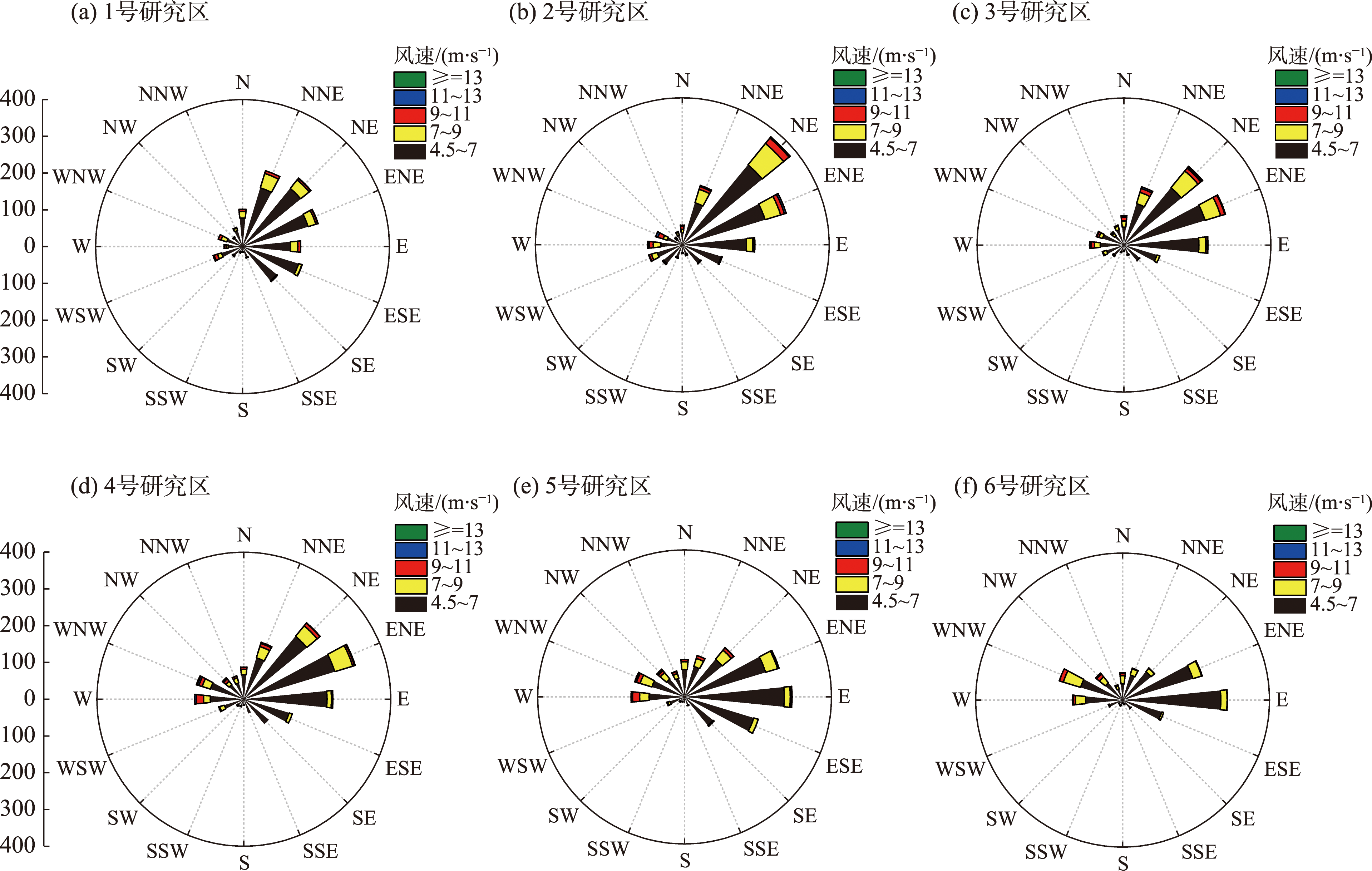

图4
各方向起沙风概率"
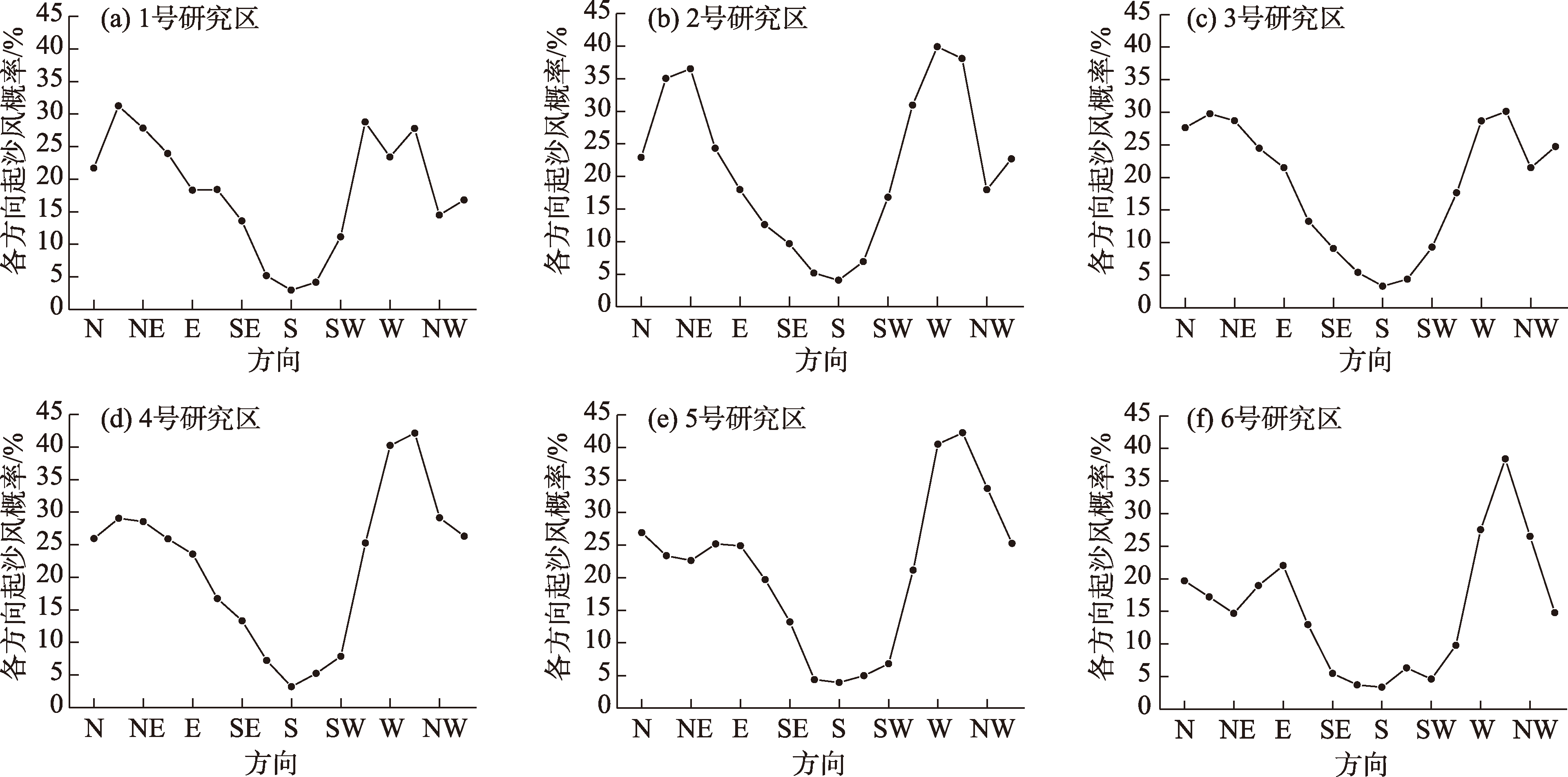
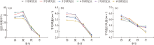
图5
各季节起沙风频率、平均风速与平均起沙风速"

图6
季节起沙风风频"


图7
各研究区月起沙风频率、月均风速、月均起沙风速"


图8
各研究区输沙势"

表3
各研究区季节输沙势"
| 研究区 | 季节 | DP/(VU) | RDP/(VU) | RDD/(°) | RDP:DP | 研究区 | 季节 | DP/(VU) | RDP/(VU) | RDD/(°) | RDP:DP |
|---|---|---|---|---|---|---|---|---|---|---|---|
| 1 | 春 | 51.51 | 10.99 | 193.05 | 0.22 | 4 | 春 | 78.47 | 25.57 | 170.52 | 0.33 |
| 夏 | 43.78 | 25.41 | 228.95 | 0.58 | 夏 | 48.56 | 27.75 | 205.89 | 0.51 | ||
| 秋 | 14.59 | 6.10 | 202.81 | 0.42 | 秋 | 9.96 | 4.22 | 167.43 | 0.32 | ||
| 冬 | 1.95 | 0.84 | 92.22 | 0.43 | 冬 | 4.09 | 1.03 | 189.31 | 0.25 | ||
| 2 | 春 | 72.01 | 27.32 | 195.15 | 0.34 | 5 | 春 | 76.25 | 23.49 | 168.00 | 0.31 |
| 夏 | 50.51 | 34.50 | 224.82 | 0.60 | 夏 | 52.71 | 23.29 | 198.49 | 0.44 | ||
| 秋 | 15.00 | 4.52 | 147.67 | 0.30 | 秋 | 13.32 | 4.35 | 143.44 | 0.33 | ||
| 冬 | 3.25 | 1.58 | 235.48 | 0.48 | 冬 | 3.02 | 0.48 | 155.67 | 0.16 | ||
| 3 | 春 | 74.66 | 39.11 | 216.78 | 0.52 | 6 | 春 | 39.95 | 15.81 | 161.31 | 0.40 |
| 夏 | 40.48 | 27.38 | 210.04 | 0.60 | 夏 | 39.41 | 19.18 | 164.40 | 0.44 | ||
| 秋 | 24.64 | 3.30 | 212.82 | 0.20 | 秋 | 18.85 | 5.18 | 221.82 | 0.28 | ||
| 冬 | 2.93 | 0.87 | 211.44 | 0.29 | 冬 | 1.56 | 0.60 | 224.61 | 0.39 |
表4
各研究区沙丘移动"
| 研究区 | 沙丘垂直投影面积 | 移动方向 | 移动速率 | |||||||
|---|---|---|---|---|---|---|---|---|---|---|
| 范围/m2 | 均值/m2 | 范围/(°) | 均值/(°) | 方差 | 范围/(m·a-1) | 均值/(m·a-1) | 方差 | |||
| 1号研究区 | 5150~42252 | 20083 | 185.76~198.20 | 192.52 | 12.51 | 0.98~1.40 | 1.19 | 0.02 | ||
| 2号研究区 | 8820~27745 | 14268 | 169.41~199.23 | 185.44 | 38.39 | 1.14~1.90 | 1.45 | 0.04 | ||
| 3号研究区 | 4899~48972 | 13503 | 161.09~196.29 | 186.28 | 44.96 | 2.07~3.38 | 2.55 | 0.09 | ||
| 4号研究区 | 1809~8008 | 4229 | 156.31~192.37 | 177.80 | 95.29 | 2.42~3.33 | 2.83 | 0.07 | ||
| 5号研究区 | 1134~3420 | 2119 | 153.91~190.66 | 171.76 | 84.09 | 3.26~4.36 | 3.69 | 0.13 | ||
| 6号研究区 | 1194~4416 | 2317 | 159.20~191.48 | 175.43 | 63.21 | 1.36~2.13 | 1.74 | 0.05 | ||

图9
各研究区沙丘移动速率与垂直投影面积的关系"

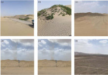
图10
研究区自然环境"


图11
沙障布置示意图"

| [1] |
Hu Z, Gao X, Zhao Y, et al. Effect of the Mazar Tagh Mountains on aeolian landforms in the western Taklamakan Desert, northwestern China[J]. Geomorphology, 2022, 418: 108464.
doi: 10.1016/j.geomorph.2022.108464 |
| [2] | 王敏仲. 塔克拉玛干沙漠沙尘暴天气及地表热力气候特征研究[D]. 乌鲁木齐: 新疆师范大学, 2008. |
| [Wang Minzhong. The Study of Sandstorm Weather and Surface Heat Climate Characteristics in Taklimakan Desert[D]. Urumqi: Xinjiang Normal University, 2008.] | |
| [3] | 王训明, 董治宝, 陈广庭. 塔克拉玛干沙漠中部部分地区风沙环境特征[J]. 中国沙漠, 2001, 21(1): 59-64. |
| [Wang Xunming, Dong Zhibao, Chen Guangting. Characteristics of blown sand environment in middle Taklimakan Desert[J]. Journal of Desert Research, 2001, 21(1): 59-64.] | |
| [4] |
郭彩贇, 韩致文, 李爱敏. 塔克拉玛干沙漠地区沙尘暴研究进展[J]. 中国沙漠, 2016, 36(6): 1646-1652.
doi: 10.7522/j.issn.1000-694X.2015.00262 |
|
[Guo Caiyun, Han Zhiwen, Li Aimin. Research progress of dust storms in the Taklimakan Desert[J]. Journal of Desert Research, 2016, 36(6): 1646-1652.]
doi: 10.7522/j.issn.1000-694X.2015.00262 |
|
| [5] | 周成龙, 杨兴华, 钟昕洁, 等. 塔克拉玛干沙漠腹地沙尘天气特征[J]. 干旱区研究, 2017, 34(2): 324-329. |
| [Zhou Chenglong, Yang Xinghua, Zhong Xinjie, et al. Dust weather in hinterland of the Taklamakan Desert[J]. Arid Zone Research, 2017, 34(2): 324-329.] | |
| [6] | 俎瑞平, 张克存, 屈建军, 等. 塔克拉玛干沙漠风况特征研究[J]. 干旱区地理, 2005, 28(2): 167-170. |
| [Zu Ruiping, Zhang Kecun, Qu Jianjun, et al. Study on wind regime characteristics in the Taklimakan Desert[J]. Arid Land Geography, 2005, 28(2): 167-170.] | |
| [7] | 孙小雲, 房彦杰, 赵景峰, 等. 塔克拉玛干沙漠输沙势时空分布特征[J]. 干旱区地理, 2020, 43(1): 38-47. |
| [Sun Xiaoyun, Fang Yanjie, Zhao Jingfeng, et al. Spatial and temporal distribution characteristics of sand drift potential in Taklimakan Desert[J]. Arid Land Geography, 2020, 43(1): 38-47.] | |
| [8] |
Sun W, Gao X. Geomorphology of sand dunes in the Taklamakan Desert based on ERA5 reanalysis data[J]. Journal of Arid Environments, 2022, 207: 104848.
doi: 10.1016/j.jaridenv.2022.104848 |
| [9] | 王旭, 王昀, 陈宝欣, 等. 塔里木盆地风沙灾害强度和频次的时空分布特征[J]. 干旱区地理, 2021, 44(6): 1590-1600. |
| [Wang Xu, Wang Yun, Chen Baoxin, et al. Spatial and temporal distribution characteristics of intensity and frequency of wind-sand disasters in Tarim Basin[J]. Arid Land Geography, 2021, 44(6): 1590-1600.] | |
| [10] | 邢文娟, 雷加强, 王海峰, 等. 荒漠-绿洲过渡带风况及输沙势分析——以策勒县为例[J]. 干旱区研究, 2008, 24(6): 894-898. |
| [Xing Wenjuan, Lei Jiaqiang, Wang Haifeng, et al. Analysis on wind regime and wind borne sand potential in a desert-oasis ecotone——A case study in Qira County, Xinjiang[J]. Arid Zone Research, 2008, 24(6): 894-898.] | |
| [11] | 孙佳琦. 巴丹吉林沙漠地区风况与风能环境观测研究[D]. 兰州: 兰州大学, 2020. |
| [Sun Jiaqi. Wind Regime and Drift Potential in the Badain Jaran Desert Based on Observation[D]. Lanzhou: Lanzhou University, 2020.] | |
| [12] | 杨兴华, 何清, 霍文, 等. 策勒绿洲-荒漠过渡带风沙前沿近地面不同方向的输沙特征[J]. 干旱区研究, 2012, 29(6): 1100-1104. |
| [Yang Xinghua, He Qing, Huo Wen, et al. Study on wind-blown sand characteristics at different directions near the surface in the frontier of an oasis-desert ecotone in Qira County, Xinjiang[J]. Arid Zone Research, 2012, 29(6): 1100-1104.] | |
| [13] |
顾立霞, 吕萍, 马芳, 等. 不同数据源下毛乌素沙地风况及输沙势特征[J]. 中国沙漠, 2022, 42(5): 54-62.
doi: 10.7522/j.issn.1000-694X.2022.00014 |
|
[Gu Lixia, Lv Ping, Ma Fang, et al. Drift potential characteristics of Mu Us Sandy Land calculated with different data sources[J]. Journal of Desert Research, 2022, 42(5): 54-62.]
doi: 10.7522/j.issn.1000-694X.2022.00014 |
|
| [14] |
冯净雪, 丁占良, 尤莉, 等. 科尔沁沙地西部横向沙丘间的风况和输沙势[J]. 中国沙漠, 2022, 42(4): 110-119.
doi: 10.7522/j.issn.1000-694X.2022.00017 |
|
[Feng Jingxue, Ding Zhanliang, You Li, et al. Wind regimes and drift potentials in the corridor of transverse dunefield in western Korqin Sandy Land[J]. Journal of Desert Research, 2022, 42(4): 110-119.]
doi: 10.7522/j.issn.1000-694X.2022.00017 |
|
| [15] | 郑智鹏, 马奔腾, 程建军, 等. 尉犁—且末沙漠公路沿线风沙环境特征及沙害防治对策研究[J]. 干旱区地理, 2023, 46(10): 1680-1691. |
| [Zheng Zhipeng, Ma Benteng, Cheng Jianjun, et al. Characteristics of wind-sand environment and control measures of sand damage along Yuli-Qiemo desert highway[J]. Arid Land Geography, 2023, 46(10): 1680-1691.] | |
| [16] | 苗恒录, 王健, 张瑞强, 等. 内蒙古阴山北麓荒漠草原风况与输沙势研究——以希拉穆仁草原为例[J]. 干旱区资源与环境, 2022, 36(4): 102-110. |
| [Miao Henglu, Wang Jian, Zhang Ruiqiang, et al. Characteristics of wind regime and drift potential of the desert steppe in northern slope of Yinshan Mountains, Inner Mongolia[J]. Journal of Arid Land Resources and Environment, 2022, 36(4): 102-110.] | |
| [17] | 崔珂军, 李生宇, 范敬龙, 等. 蒙古国中部草原地区风蚀沙漠化的风沙活动特征——以乔伊尔市为例[J]. 干旱区地理, 2022, 45(3): 792-801. |
| [Cui Kejun, Li Shengyu, Fan Jinglong, et al. Aeolian sand activity characteristics of wind erosion and desertification in the grassland area of central Mongolia: A case of Choir City[J]. Arid Land Geography, 2022, 45(3): 792-801.] | |
| [18] | 马奔腾, 程建军, 雷加强, 等. 南疆塔中-38团沙漠公路沿线风沙输移规律与防沙体系研究[J]. 干旱区研究, 2022, 39(5): 1663-1672. |
| [Ma Benteng, Cheng Jianjun, Lei Jiaqiang, et al. Transport law and control system of wind-blown sand along the desert highway of South Xinjiang Tazhong-38th Corp[J]. Arid Zone Research, 2022, 39(5): 1663-1672.] | |
| [19] | 何晨晨, 吴盈盈, 田永胜, 等. 民勤绿洲外围新月形沙丘宽高比与移动速率变化特征[J]. 干旱区研究, 2023, 40(2): 280-291. |
| [He Chenchen, Wu Yingying, Tian Yongsheng, et al. Variation characteristics of width-height ratio and migration speed of barchans at the margin of Minqin oasis[J]. Arid Zone Research, 2023, 40(2): 280-291.] | |
| [20] |
张云枫, 马义娟, 苏志珠, 等. 巴丹吉林沙漠与腾格里沙漠连接带沙丘移动规律[J]. 中国沙漠, 2022, 42(5): 82-91.
doi: 10.7522/j.issn.1000-694X.2022.00020 |
|
[Zhang Yunfeng, Ma Yijuan, Su Zhizhu, et al. Dune movement in the joint zone of the Badain Jaran Desert and Tengger Desert[J]. Journal of Desert Research, 2022, 42(5): 82-91.]
doi: 10.7522/j.issn.1000-694X.2022.00020 |
|
| [21] | 贾光普. 阿拉善戈壁地区新月形沙丘形态特征与动态演变过程研究[D]. 呼和浩特: 内蒙古农业大学, 2022. |
| [Jia Guangpu. Morphological Characteristics and Dynamic Evolution Process of Crescent-shaped Sand Dunes in the Alashan Gobi Region[D]. Hohhot: Inner Mongolia Agricultural University, 2022.] | |
| [22] | 李建军, 焦菊英, 曹雪, 等. 柴达木盆地沙丘移动的空间分异及对形态参数的响应[J]. 农业工程学报, 2021, 37(7): 309-314. |
| [Li Jianjun, Jiao Juying, Cao Xue, et al. Spatial regionalization and response to morphological parameters of dune migration in the Qaidam Basin of China[J]. Transactions of the Chinese Society of Agricultural Engineering, 2021, 37(7): 309-314.] | |
| [23] | 杨军怀. 塔克拉玛干沙漠沙丘移动研究[D]. 西安: 陕西师范大学, 2019. |
| [Yang Junhuai. Study on Dune Movement in Taklimakan Desert[D]. Xi’an: Shaanxi Normal University, 2019.] | |
| [24] |
李爱敏, 韩致文. 新月形沙丘形态参数与移动速度的关系[J]. 中国沙漠, 2020, 40(1): 29-40.
doi: 10.7522/j.issn.1000-694X.2019.00032 |
|
[Li Aimin, Han Zhiwen. Relationship between moving speed and morphological parameters of barchan dunes[J]. Journal of Desert Research, 2020, 40(1): 29-40.]
doi: 10.7522/j.issn.1000-694X.2019.00032 |
|
| [25] |
杨军怀, 董治宝, 刘铮瑶, 等. 库鲁克沙漠风沙地貌与沙丘移动[J]. 中国沙漠, 2019, 39(4): 1-8.
doi: 10.7522/j.issn.1000-694X.2018.00100 |
|
[Yang Junhuai, Dong Zhibao, Liu Zhengyao, et al. Aeolian geomorphology and dune migration in the Quruq Desert, China[J]. Journal of Desert Research, 2019, 39(4): 1-8.]
doi: 10.7522/j.issn.1000-694X.2018.00100 |
|
| [26] | 刘宇胜. 阿拉善北部戈壁地区新月形沙丘移动规律研究[D]. 呼和浩特: 内蒙古农业大学, 2018. |
| [Liu Yusheng. The Study on the Law of Barchan Dunes’ Movement in the Gobi Area in Northern Alxa[D]. Hohhot: Inner Mongolia Agricultural University, 2018.] | |
| [27] | 王静璞, 刘连友, 沈玲玲. 基于Google Earth的毛乌素沙地新月形沙丘移动规律研究[J]. 遥感技术与应用, 2013, 28(6): 1094-1100. |
| [Wang Jingpu, Liu Lianyou, Shen Lingling. Research of the barchan dunes movement in the Mu Us Sandy Land on Google Earth software[J]. Remote Sensing Technology and Application, 2013, 28(6): 1094-1100.] | |
| [28] | 张克存, 安志山, 何明珠, 等. 乌海至玛沁高速公路中卫段风沙环境特征及沙害防治[J]. 干旱区地理, 2021, 44(4): 983-991. |
| [Zhang Kecun, An Zhishan, He Mingzhu, et al. Aeolian sand environments and disaster prevention along Zhongwei section of the Wuhai-Maqin highway[J]. Arid Land Geography, 2021, 44(4): 983-991.] | |
| [29] | 谢胜波, 屈建军, 赖远明, 等. 拉日铁路沙害成因、分布、特征及防治研究[J]. 干旱区资源与环境, 2016, 30(2): 170-175. |
| [Xie Shengbo, Qu Jianjun, Lai Yuanming, et al. The causes, distributions, characteristics of sand hazards and its controls for Lhasa-Shigatse railway[J]. Journal of Arid Land Resources and Environment, 2016, 30(2): 170-175.] | |
| [30] |
张克存, 安志山, 何明珠, 等. 中国沙区公路风沙危害及防治研究进展[J]. 中国沙漠, 2022, 42(3): 222-232.
doi: 10.7522/j.issn.1000-694X.2022.00048 |
|
[Zhang Kecun, An Zhishan, He Mingzhu, et al. Progress of research on wind-blown sand prevention and control along highways in China[J]. Journal of Desert Research, 2022, 42(3): 222-232.]
doi: 10.7522/j.issn.1000-694X.2022.00048 |
|
| [31] |
Dong Z, Chen G, He X, et al. Controlling blown sand along the highway crossing the Taklimakan Desert[J]. Journal of Arid Environments, 2002, 57(3): 329-344.
doi: 10.1016/j.jaridenv.2002.02.001 |
| [32] | 李锦荣, 王健, 王茹, 等. 基于无人机技术黄河沿岸沙丘移动速度监测及影响因素分析[J]. 农业工程学报, 2021, 37(19): 57-64. |
| [Li Jinrong, Wang Jian, Wang Ru, et al. Monitoring and influencing factors of dune movement speed along the Yellow River using UAV technology[J]. Transactions of the Chinese Society of Agricultural Engineering, 2021, 37(19): 57-64.] | |
| [33] | 赛亚热·赛都拉, 毛东雷, 徐佳瑞, 等. 库姆塔格沙漠西缘风况特征及沙丘运移规律[J]. 水土保持学报, 2021, 35(6): 62-68. |
| [Saidoula Saiyare, Mao Donglei, Xu Jiarui, et al. Characteristics of wind conditions and dune movement rules on the west edge of Kumtag Desert, China[J]. Journal of Soil and Water Conservation, 2021, 35(6): 62-68.] | |
| [34] | 陈芳, 刘勇. 巴丹吉林沙漠典型地域沙丘多年变化的遥感动态分析[J]. 遥感技术与应用, 2011, 26(4): 501-507. |
| [Chen Fang, Liu Yong. Secular annual movement of sand dunes in Badain Jaran Desert based on geographic analyses of remotely sensed imagery[J]. Remote Sensing Technology and Application, 2011, 26(4): 501-507.] | |
| [35] | Fryberger S, Dean G. Dune forms and wind regime[C]// Mckee E D. A Study of Global Sand Seas. Washington: United States Government Printing Office, 1979: 137-169. |
| [36] | 朱震达. 塔克拉玛干沙漠风沙地貌研究[M]. 北京: 科学出版社, 1981. |
| [Zhu Zhenda. Aeolian Geomorphology of Taklimakan Desert[M]. Beijing: Science Press, 1981.] | |
| [37] | 李生宇, 雷加强, 徐新文, 等. 塔里木沙漠公路对近地表风沙运动过程的影响[J]. 干旱区研究, 2007, 24(2): 247-254. |
| [Li Shengyu, Lei Jiaqiang, Xu Xinwen, et al. Study on the effects of the Tarim desert highway on the process of blown sand movement near the ground surface[J]. Arid Zone Research, 2007, 24(2): 247-254.] | |
| [38] | 张建国, 徐新文, 雷加强, 等. 塔里木沙漠公路风沙危害与防护体系研究进展[J]. 西北林学院学报, 2009, 24(2): 50-54. |
| [Zhang Jianguo, Xu Xinwen, Lei Jiaqiang, et al. Progress in the researches of sand drift disasters and defense system along the trim desert highway[J]. Journal of Northwest Forestry University, 2009, 24(2): 50-54.] | |
| [39] | 席成, 左合君, 王海兵, 等. 高立式尼龙网沙障防风阻沙特征及其合理配置[J]. 干旱区研究, 2021, 38(3): 882-891. |
| [Xi Cheng, Zuo Hejun, Wang Haibing, et al. Wind-proof and sand-blocking characteristics of high vertical nylon mesh sand barrier and its rational allocation[J]. Arid Zone Research, 2021, 38(3): 882-891.] | |
| [40] | 丁录胜, 程建军, 陈柏羽, 等. 铁路高立式芦苇沙障防风阻沙的现场测试与流场模拟计算[J]. 水土保持通报, 2019, 39(3): 156-162. |
| [Ding Lusheng, Cheng Jianjun, Chen Boyu, et al. Field test and numerical simulation of windbreak and sand-resisting on high-parallel reed sand-barriers along railway[J]. Bulletin of Soil and Water Conservation, 2019, 39(3): 156-162.] | |
| [41] | 王振清. 中国公路防沙治沙[M]. 沈阳: 辽宁大学出版社, 2000. |
| [Wang Zhenqing. Prevention and Control of Highway Sand Damage in China[M]. Shenyang: Liaoning University Publishing House, 2000.] |
| [1] | 刘鑫, 高鑫. 塔克拉玛干沙漠南缘新月形沙丘移动特征[J]. 干旱区研究, 2024, 41(4): 661-673. |
| [2] | 薛承杰, 张克存, 安志山, 张宏雪, 潘加朋. 铁路高架桥对局地风动力的影响——以敦格铁路沙山沟为例[J]. 干旱区研究, 2023, 40(10): 1678-1686. |
| [3] | 张昊, 党晓宏, 蒙仲举, 高永, 刘阳, 秦青船. 乌珠穆沁沙地主要风沙环境特征及形成机制研究[J]. 干旱区研究, 2023, 40(10): 1687-1697. |
| [4] | 马奔腾,程建军,雷加强,丁泊淞,高丽,安元锋,郑智鹏. 南疆塔中-38团沙漠公路沿线风沙输移规律与防沙体系研究[J]. 干旱区研究, 2022, 39(5): 1663-1672. |
| [5] | 杨兴华,马明杰,周成龙,何清. 不同起沙阈值判定方案在塔克拉玛干沙漠的适用性对比研究[J]. 干旱区研究, 2022, 39(4): 1006-1016. |
| [6] | 朱从祯,赵天良,孟露,杨兴华,何清,买买提艾力·买买提依明,杨婕,朱燕,吴昭烨. 浮尘气溶胶对沙漠大气边界层结构作用的昼夜差异[J]. 干旱区研究, 2022, 39(4): 1017-1026. |
| [7] | 李火青, 金莉莉 , 买买提艾力·买买提依明 , 赵佳伟. 荒漠土壤成分对陆面过程的影响研究[J]. 干旱区研究, 2020, 37(1): 18-25. |
| [8] | 曹寰琦, 何清, 金莉莉, 李振杰, 杨兴华, 霍文. 塔克拉玛干沙漠北缘夏秋冬季地表能量平衡闭合特征[J]. 干旱区研究, 2018, 35(4): 821-829. |
| [9] | 王永东,邱永志,许波,张忠良,李生宇. 参考作物蒸散量计算方法在极端干旱区的适用性[J]. 干旱区研究, 2014, 31(3): 390-396. |
| [10] | 杨帆,王雪芹,何清,郑新倩,韩章勇,霍文. 绿洲-沙漠过渡带柽柳灌丛沙堆形态特征及空间分布格局[J]. 干旱区研究, 2014, 31(3): 556-563. |
| [11] | 杨兴华,何清,霍文,艾力?买买提依明,刘新春. 沙漠地区不同下垫面近地表沙尘水平通量研究[J]. 干旱区研究, 2014, 31(3): 564-569. |
| [12] | 王宁波,谷峰,李生宇,王海峰,徐新文,雷加强,张忠良. 塔克拉玛干沙漠腹地复合纵向沙垄间地沙丘空间分形及稳定性[J]. 干旱区研究, 2014, 31(1): 163-168. |
| [13] | 杨兴华, 何清, 程玉景, 范新明. 策勒绿洲-荒漠过渡带风沙前沿近地表沙尘水平通量观测[J]. 干旱区研究, 2013, 30(6): 1100-1105. |
| [14] | 张利刚, 曾凡江, 刘镇, 刘波, 安桂香, 袁娜. 极端干旱区3种植物液流特征及其对环境因子的响应[J]. 干旱区研究, 2013, 30(1): 115-121. |
| [15] | 杨兴华, 何清, 霍文, 程玉景. 策勒绿洲-荒漠过渡带风沙前沿近地面不同方向的输沙特征[J]. 干旱区研究, 2012, 29(6): 1100-1104. |
|
||