干旱区研究 ›› 2023, Vol. 40 ›› Issue (8): 1258-1267.doi: 10.13866/j.azr.2023.08.06 cstr: 32277.14.AZR.20230806
李小雨( ),贾科利(),魏慧敏,陈睿华,王怡婧
收稿日期:2023-01-06
修回日期:2023-06-12
出版日期:2023-08-15
发布日期:2023-08-24
作者简介:李小雨(1997-),女,硕士研究生,主要从事遥感监测与分析研究. E-mail: 基金资助:
LI Xiaoyu(),JIA Keli(),WEI Huimin,CHEN Ruihua,WANG Yijing
Received:2023-01-06
Revised:2023-06-12
Published:2023-08-15
Online:2023-08-24
摘要:
快速监测区域土壤盐渍化信息,对于盐渍化治理与生态环境保护具有重要意义。本文以Sentinel-2A和Landsat8 OLI遥感影像为数据源,以银川平原为研究区,利用谷歌地球引擎(Google Earth Engine,GEE)平台,基于随机森林算法,通过建立光谱指数特征与地面实测土壤含盐量之间的关系,进行土壤含盐量估算。结果表明:GEE能够为土壤含盐量预测提供可靠的数据支撑;以Sentinel-2A为数据源建立的随机森林模型具有更好的预测精度(R2=0.789,RMSE=1.487),优于Landsat8 OLI,可用于土壤含盐量高分辨率遥感估算,能够为大尺度土壤含盐量监测工作提供理论支撑。
李小雨, 贾科利, 魏慧敏, 陈睿华, 王怡婧. 基于随机森林算法的土壤含盐量预测[J]. 干旱区研究, 2023, 40(8): 1258-1267.
LI Xiaoyu, JIA Keli, WEI Huimin, CHEN Ruihua, WANG Yijing. Prediction of soil salt content based on the random forest algorithm[J]. Arid Zone Research, 2023, 40(8): 1258-1267.

图1
研究区位置和采样点分布"

表1
光谱指数计算公式"
| 光谱指数 | 计算公式 | 参考文献 |
|---|---|---|
| 盐分指数(SI_T) | (Red-NIR)×100 | [ |
| 盐分指数1(SI1) | [ | |
| 盐分指数2(SI2) | [ | |
| 盐分指数3(SI3) | [ | |
| 盐分指数4(SI4) | (Blue×Red)/Green | [ |
| 盐分指数5(SI5) | (Green+Red)/2 | [ |
| 盐渍化指数1(S1) | Blue/Red | [ |
| 盐渍化指数2(S2) | (Blue-Red)/(Blue+Red) | [ |
| 盐渍化指数3(S3) | (Green×Red)/Blue | [ |
| 盐度比值指数(SAIO) | (Red-NIR)/(Green+NIR) | [ |
| 土壤调节植被指数(SAVI) | [(NIR-Red)×(1+L)]/(NIR+Red+L);L=0.5 | [ |
| 绿度差值植被指数(GDVI) | (NIR2-Red2)/(NIR2+Red2) | [ |
| 冠层响应盐度指数(CRSI) | [ |
表2
银川平原土壤样本统计"
| 盐渍化等级 | 含盐量/(g·kg-1) | 样本数量 | 含盐量均值/(g·kg-1) | 含盐量最大值/(g·kg-1) | 含盐量最小值/(g·kg-1) | 变异系数/% |
|---|---|---|---|---|---|---|
| 非盐渍化 | <1 | 91 | 0.56 | 0.98 | 0.09 | 39.79 |
| 轻度盐渍化 | 1~2 | 64 | 1.46 | 1.96 | 1.00 | 20.09 |
| 中度盐渍化 | 2~4 | 55 | 2.82 | 3.97 | 2.00 | 19.42 |
| 重度盐渍化 | 4~6 | 37 | 4.90 | 5.91 | 4.06 | 11.97 |
| 盐土 | >6 | 50 | 12.00 | 20.74 | 6.14 | 35.10 |
| 总样本 | 297 | 3.63 | 20.74 | 0.09 | 138.76 | |
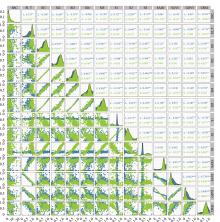
图2
光谱指数与土壤盐分的相关性 注:(1) *表示显著性检验P<0.05,**表示显著性检验P<0.01,***表示显著性检验P<0.001;(2) 左下区为土壤含盐量(SSC)与13个光谱参数的两两关系散点图,右上区为对应的相关系数值,中间斜对角为对应横轴的核密度估计图;(3) 图中不同颜色代表不同数据源,蓝色代表以Landsat8 OLI为数据源计算得出的相关系数,绿色代表以Sentinel-2A为数据源计算得出的相关系数。"

表3
基于不同数据源的随机森林模型"
| 数据源 | 建模集(n=198) | 验证集(n=99) | |||
|---|---|---|---|---|---|
| R2 | RMSE | R2 | RSME | ||
| Landsat8 OLI | 0.615 | 3.169 | 0.734 | 1.698 | |
| Sentinel-2A | 0.633 | 2.875 | 0.789 | 1.487 | |

图3
土壤盐分与模型预测值的散点图"

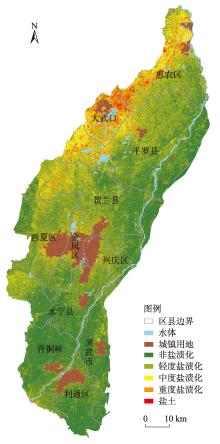
图4
土壤含盐量反演等级分布"

表4
银川平原不同等级盐分反演像元数及占比"
| 盐渍化等级 | 像元数 | 面积/km2 | 占比/% |
|---|---|---|---|
| 非盐渍化 | 29115098 | 2916.701 | 41.620 |
| 轻度盐渍化 | 23348676 | 2332.925 | 33.290 |
| 中度盐渍化 | 10886719 | 1086.069 | 15.498 |
| 重度盐渍化 | 5121100 | 511.611 | 7.301 |
| 盐土 | 1609153 | 160.567 | 2.291 |
| [1] | 李星, 李凯锋. 土壤盐渍化开发利用研究进展[J]. 农业科技通讯, 2018, 23(6): 244-246. |
| [ Li Xing, Li Kaifeng. Research progress of soil salinization development and utilization[J]. Agricultural Science and Technology Bulletin, 2018, 23(6): 244-246. ] | |
| [2] |
Nachshon U. Cropland soil salinization and associated hydrology: Trends, processes and examples[J]. Water, 2018, 10(8): 1030.
doi: 10.3390/w10081030 |
| [3] | Zaman M, Shahid S A, Heng L. Guideline for Salinity Assessment, Mitigation and Adaptation Using Nuclear and Related Techniques[M]. Springer Nature, 2018. |
| [4] | 杨真, 王宝山. 中国盐渍土资源现状及改良利用对策[J]. 山东农业科学, 2015, 47(4): 125-130. |
| [ Yang Zhen, Wang Baoshan. Present situation of saline soil resources in China and its improvement and utilization strategy[J]. Shandong Agricultural Sciences, 2015, 47(4): 125-130. ] | |
| [5] | 曹雷, 丁建丽, 玉米提·哈力克, 等. 基于国产高分一号卫星数据的区域土壤盐渍化信息提取与建模[J]. 土壤学报, 2016, 53(6): 1399-1409. |
| [ Cao Lei, Ding Jianli, Coranti Hallick, et al. Extraction and modeling of regional soil salinization based on domestic Gaofen-1 satellite data[J]. Acta Pedologica Sinica, 2016, 53(6): 1399-1409. ] | |
| [6] |
Meng L, Zhou S, Zhang H, et al. Estimating soil salinity in different landscapes of the Yellow River Delta through Landsat OLI/TIRS and ETM+ Data[J]. Journal of Coastal Conservation, 2016, 20(4): 271-279.
doi: 10.1007/s11852-016-0437-9 |
| [7] |
Farifteh J, Farshad A, George R J. Assessing salt-affected soils using remote sensing, solute modelling, and geophysics[J]. Geoderma, 2006, 130(3-4): 191-206.
doi: 10.1016/j.geoderma.2005.02.003 |
| [8] |
Hu J, Peng J, Zhou Y, et al. Quantitative estimation of soil salinity using UAV-borne hyperspectral and satellite multispectral images[J]. Remote Sensing, 2019, 11(7): 736.
doi: 10.3390/rs11070736 |
| [9] |
Metternicht G I, Zinck J A. Remote sensing of soil salinity: Potentials and constraints[J]. Remote sensing of Environment, 2003, 85(1): 1-20.
doi: 10.1016/S0034-4257(02)00188-8 |
| [10] |
Fan X, Weng Y, Tao J. Towards decadal soil salinity mapping using Landsat time series data[J]. International Journal of Applied Earth Observation and Geoinformation, 2016, 52: 32-41.
doi: 10.1016/j.jag.2016.05.009 |
| [11] | Ivushkin K, Bartholomeus H, Bregt A K, et al. Global mapping of soil salinity change[J]. Remote Sensing of Environment, 2019, 231: 111-160. |
| [12] | 黄晓宇, 王雪梅, 卡吾恰提·白山. 基于Landsat8 OLI影像干旱区绿洲土壤含盐量反演[J]. 自然资源遥感, 2023, 35(1): 189-197. |
| [ Huang Xiaoyu, Wang Xuemei, Kawuciati Baishan. Inversion of soil salt content in arid oasis based on Landsat8 OLI image[J]. Remote Sensing of Natural Resources, 2023, 35(1): 189-197. ] | |
| [13] | 杨宁, 崔文轩, 张智韬, 等. 无人机多光谱遥感反演不同深度土壤盐分[J]. 农业工程学报, 2020, 36(22): 13-21. |
| [ Yang Ning, Cui Wenxuan, Zhang Zhitao, et al. Inversion of soil salinity at different depths by UAV multi-spectral remote sensing[J]. Transactions of the Chinese Society of Agricultural Engineering, 2020, 36(22): 13-21. ] | |
| [14] | 陈俊英, 姚志华, 张智韬, 等. 大田葵花土壤含盐量无人机遥感反演研究[J]. 农业机械学报, 2020, 51(7): 178-191. |
| [ Chen Junying, Yao Zhihua, Zhang Zhitao, et al. Uav remote sensing inversion of soil salt content in sunflower of Dantian[J]. Transactions of the Chinese Society for Agricultural Machinery, 2020, 51(7): 178-191. ] | |
| [15] | 厉彦玲, 赵庚星, 常春艳, 等. OLI与HSI影像融合的土壤盐分反演模型[J]. 农业工程学报, 2017, 33(21): 533-544. |
| [ Li Yanling, Zhao Gengxing, Chang Chunyan, et al. Soil salinity inversion model based on OLI and HSI image fusion[J]. Transactions of the CSAE, 2017, 33(21): 533-544. ] | |
| [16] | 张智韬, 魏广飞, 姚志华, 等. 基于无人机多光谱遥感的土壤含盐量反演模型研究[J]. 农业机械学报, 2019, 50(12): 151-160. |
| [ Zhang Zhitao, Wei Guangfei, Yao Zhihua, et al. Inversion model of soil salt content based on UAV multi-spectral remote sensing[J]. Transactions of the Chinese Society for Agricultural Machinery, 2019, 50(12): 151-160. ] | |
| [17] | Fathizad H, Ardakani M A H, Sodaiezadeh H, et al. Investigation of the spatial and temporal variation of soil salinity using random forests in the central desert of Iran[J]. Geoderma, 2020, 365: 114-233. |
| [18] |
Liu X, Hu G, Chen Y, et al. High-resolution multi-temporal mapping of global urban land using Landsat images based on the Google Earth Engine platform[J]. Remote Sensing of Environment, 2018, 209: 227-239.
doi: 10.1016/j.rse.2018.02.055 |
| [19] |
Simonetti D, Simonetti E, Szantoi Z, et al. First results from the phenology-based synthesis classifier using Landsat 8 imagery[J]. IEEE Geoscience and Remote Sensing Letters, 2015, 12(7): 1496-1500.
doi: 10.1109/LGRS.2015.2409982 |
| [20] |
徐晗泽宇, 刘冲, 王军邦, 等. Google Earth Engine平台支持下的赣南柑橘果园遥感提取研究[J]. 地球信息科学学报, 2018, 20(3): 396-404.
doi: 10.12082/dqxxkx.2018.170553 |
|
[ Xu Hanzeyu, Liu Chong, Wang Junbang, et al. Remote sensing extraction of citrus orchards in Southern Jiangxi Province supported by Google Earth Engine[J]. Journal of Geoinformation Science, 2018, 20(3): 396-404. ]
doi: 10.12082/dqxxkx.2018.170553 |
|
| [21] |
Dong J, Xiao X, Menarguez M A, et al. Mapping paddy rice planting area in northeastern Asia with Landsat 8 images, phenology-based algorithm and Google Earth Engine[J]. Remote Sensing of Environment, 2016, 185: 142-154.
doi: 10.1016/j.rse.2016.02.016 pmid: 28025586 |
| [22] |
Lobell D B, Thau D, Seifert C, et al. A scalable satellite-based crop yield mapper[J]. Remote Sensing of Environment, 2015, 164: 324-333.
doi: 10.1016/j.rse.2015.04.021 |
| [23] |
Tamiminia H, Salehi B, Mahdianpari M, et al. Google Earth Engine for geo-big data applications: A meta-analysis and systematic review[J]. ISPRS Journal of Photogrammetry and Remote Sensing, 2020, 164: 152-170.
doi: 10.1016/j.isprsjprs.2020.04.001 |
| [24] |
Hansen M C, Potapov P V, Moore R, et al. High-resolution global maps of 21st-century forest cover change[J]. Science, 2013, 342(6160): 850-853.
doi: 10.1126/science.1244693 pmid: 24233722 |
| [25] |
Pekel J F, Cottam A, Gorelick N, et al. High-resolution mapping of global surface water and its long-term changes[J]. Nature, 2016, 540(7633): 418-422.
doi: 10.1038/nature20584 |
| [26] |
Trianni G, Lisini G, Angiuli E, et al. Scaling up to national/regional urban extent mapping using Landsat data[J]. IEEE Journal of Selected Topics in Applied Earth Observations and Remote Sensing, 2015, 8(7): 3710-3719.
doi: 10.1109/JSTARS.4609443 |
| [27] | 张源沛, 胡克林, 李保国, 等. 银川平原土壤盐分及盐渍土的空间分布格局[J]. 农业工程学报, 2009, 25(7): 19-24. |
| [ Zhang Yuanpei, Hu Keling, Li Baoguo, et al. Spatial distribution pattern of soil salinity and saline soil in Yinchuan Plain[J]. Transactions of the Chinese Society of Agricultural Engineering, 2009, 25(7): 19-24. ] | |
| [28] | 何文寿, 刘阳春, 何进宇. 宁夏不同类型盐渍化土壤水溶盐含量与其电导率的关系[J]. 干旱地区农业研究, 2010, 28(1): 111-116. |
| [ He Wenshou, Liu Yangchun, He Jinyu. Relationship between water-soluble salt content and electrical conductivity of different salinized soils in Ningxia[J]. Agricultural Research in the Arid Areas, 2010, 28(1): 111-116. ] | |
| [29] | 肖文娟. 基于GEE的近10年来云南省耕地变化遥感监测研究[D]. 昆明: 云南师范大学, 2020. |
| [ Xiao Wenjuan. Remote Sensing Monitoring of Cultivated Land Change in Yunnan Province in Recent 10 Years Based on GEE[D]. Kunming: Yunnan Normal University, 2020. ] | |
| [30] |
丁建丽, 伍漫春, 刘海霞, 等. 基于综合高光谱指数的区域土壤盐渍化监测研究[J]. 光谱学与光谱分析, 2012, 32(7): 1918-1922.
pmid: 23016353 |
|
[ Ding Jianli, Wu Manchun, Liu Haixia, et al. Monitoring of regional soil salinization based on comprehensive hyperspectral index[J]. Spectroscopy and Spectral Analysis, 2012, 32(7): 1918-1922. ]
pmid: 23016353 |
|
| [31] | 贾萍萍, 尚天浩, 张俊华, 等. 利用多源光谱信息反演宁夏银北地区干湿季土壤含盐量[J]. 农业工程学报, 2020, 36(17): 125-134. |
| [ Jia Pingping, Shang Tianhao, Zhang Junhua, et al. Inversion of soil salt content in wet and dry seasons in Yinbei Region of Ningxia using multi-source spectral information[J]. Transactions of the Chinese Society of Agricultural Engineering, 2020, 36(17): 125-134. ] | |
| [32] | 杨小虎, 罗艳琴, 杨海昌, 等. 玛纳斯河流域绿洲农田土壤盐分反演及空间分布特征[J]. 干旱区资源与环境, 2021, 35(2): 156-161. |
| [ Yang Xiaohu, Luo Yanqin, Yang Haichang, et al. Inversion and spatial distribution of soil salinity in oasis farmland in Manas River Basin[J]. Journal of Arid Land Resources and Environment, 2021, 35(2): 156-161. ] | |
| [33] | 刘旭辉, 白云岗, 柴仲平, 等. 基于多光谱遥感的典型绿洲棉田春季土壤盐分反演及验证[J]. 干旱区地理, 2022, 45(4): 1165-1175. |
| [ Liu Xuhui, Bai Yungang, Chai Zhongping, et al. Inversion and verification of soil salinity in spring in typical oasis cotton fields based on multispectral remote sensing[J]. Arid Land Geography, 2022, 45(4): 1165-1175. ] | |
| [34] | 陈俊英, 王新涛, 张智韬, 等. 基于无人机-卫星遥感升尺度的土壤盐渍化监测方法[J]. 农业机械学报, 2019, 50(12): 161-169. |
| [ Chen Junying, Wang Xintao, Zhang Zhitao, et al. Soil salinization monitoring method based on UAV-Satellite remote sensing[J]. Transactions of the Chinese Society for Agricultural Machinery, 2019, 50(12): 161-169. ] | |
| [35] | Allbed A, Kumar L, Aldakheel Y Y. Assessing soil salinity using soil salinity and vegetation indices derived from IKONOS high-spatial resolution imageries: Applications in a date palm dominated region[J]. Geoderma, 2014, 230: 1-8. |
| [36] | 樊彦国, 张维康, 刘敬一. 基于植被指数-盐分指数特征空间的黄河三角洲盐渍化遥感监测研究[J]. 山东农业科学, 2016, 48(5): 137-141. |
| [ Fan Yanguo, Zhang Weikang, Liu Jingyi. Remote sensing monitoring of salinization in Yellow River Delta based on vegetation index and salinity index feature space[J]. Shandong Agricultural Sciences, 2016, 48(5): 137-141. ] | |
| [37] | 姚远, 丁建丽, 张芳, 等. 基于高光谱指数和电磁感应技术的区域土壤盐渍化监测模型[J]. 光谱学与光谱分析, 2013, 33(6): 1658-1664. |
| [ Yao Yuan, Ding Jianli, Zhang Fang, et al. Regional soil salinization monitoring model based on hyperspectral index and electromagnetic induction technology[J]. Spectroscopy and Spectral Analysis, 2013, 33(6): 1658-1664. ] | |
| [38] | Khan S, Abbas A. Using remote sensing techniques for appraisal of irrigated soil salinity[J]. Int. Congr. Model. Simul.(MODSIM), Model. Simul. Soc. Aust. New Zealand, Bright, 2007 (January): 2632-2638. |
| [39] |
Nicolas H, Walter C. Detecting salinity hazards within a semiarid context by means of combining soil and remote-sensing data[J]. Geoderma, 2006, 134(1-2): 217-230.
doi: 10.1016/j.geoderma.2005.10.009 |
| [40] | 王飞, 杨胜天, 丁建丽, 等. 环境敏感变量优选及机器学习算法预测绿洲土壤盐分[J]. 农业工程学报, 2018, 34(22): 102-110. |
| [ Wang Fei, Yang Shengtian, Ding Jianli, et al. Optimization of environmental sensitive variables and prediction of oasis soil salinity by machine learning algorithm[J]. Transactions of the CSAE, 2018, 34(22): 102-110. ] | |
| [41] |
Huete A R. A soil-adjusted vegetation index (SAVI)[J]. Remote Sensing of Environment, 1988, 25(3): 295-309.
doi: 10.1016/0034-4257(88)90106-X |
| [42] |
Wu W. The generalized difference vegetation index (GDVI) for dryland characterization[J]. Remote Sensing, 2014, 6(2): 1211-1233.
doi: 10.3390/rs6021211 |
| [43] | Scudiero E, Skaggs T H, Corwin D L. Regional scale soil salinity evaluation using Landsat 7, western San Joaquin Valley, California, USA[J]. Geoderma Regional, 2014, 2: 82-90. |
| [44] |
Parolo G, Rossi G, Ferrarini A. Toward improved species niche modelling: Arnica montana in the Alps as a case study[J]. Journal of Applied Ecology, 2008, 45(5): 1410-1418.
doi: 10.1111/jpe.2008.45.issue-5 |
| [45] |
Breiman L. Random forests[J]. Machine Learning, 2001, 45(1): 5-32.
doi: 10.1023/A:1010933404324 |
| [46] | 曹正凤. 随机森林算法优化研究[D]. 北京: 首都经济贸易大学, 2014. |
| [ Cao Zhengfeng. Research on Optimization of Random Forest Algorithm[D]. Beijing: Capital University of Economics and Business, 2014. ] | |
| [47] | Gieseke F, Igel C. Training big random forests with little resources[C]// Proceedings of the 24th Acmsigkdd International Conference on Knowledge Discovery & Data Mining, 2018: 1445-1454. |
| [48] | 冯娟, 丁建丽, 杨爱霞, 等. 干旱区土壤盐渍化信息遥感建模[J]. 干旱地区农业研究, 2018, 36(1): 266-273. |
| [ Feng Juan, Ding Jianli, Yang Aixia, et al. Remote sensing modeling of soil salinization in arid areas[J]. Agricultural Research in the Arid Areas, 2018, 36(1): 266-273. ] | |
| [49] | 武丹, 贾科利, 张晓东, 等. 基于异质SVM神经网络的土壤盐渍化灾害预测模型[J]. 水文地质工程地质, 2018, 45(5): 143-149, 157. |
| [ Wu Dan, Jia Keli, Zhang Xiaodong, et al. Soil salinization disaster prediction model basedon heterogeneous SVM neural network[J]. Hydrogeology and Engineering Geology, 2018, 45(5): 143-149, 157. ] | |
| [50] | Morgan R S, El-Hady M A, Rahim I S. Soil salinity mapping utilizing sentinel-2 and neural networks[J]. Indian Journal of Agricultural Research, 2018, 52(5): 524-529. |
| [51] |
Allbed A, Kumar L. Soil salinity mapping and monitoring in arid and semi-arid regions using remote sensing technology: A review[J]. Advances in Remote Sensing, 2013, 2: 373-385.
doi: 10.4236/ars.2013.24040 |
| [52] | Gorji T, Yildirim A, Hamzehpour N, et al. Soil salinity analysis of Urmia Lake Basin using Landsat-8 OLI and Sentinel-2A based spectral indices and electrical conductivity measurements[J]. Ecological Indicators, 2020, 112: 106-173. |
| [53] |
Han L, Liu D, Cheng G, et al. Spatial distribution and genesis of salt on the saline playa at Qehan Lake, Inner Mongolia, China[J]. Catena, 2019, 177: 22-30.
doi: 10.1016/j.catena.2019.01.040 |
| [54] |
Wang J, Ding J, Yu D, et al. Capability of Sentinel-2 MSI data for monitoring and mapping of soil salinity in dry and wet seasons in the Ebinur Lake region, Xinjiang, China[J]. Geoderma, 2019, 353: 172-187.
doi: 10.1016/j.geoderma.2019.06.040 |
| [55] |
Zhang T T, Qi J G, Gao Y, et al. Detecting soil salinity with MODIS time series VI data[J]. Ecological Indicators, 2015, 52: 480-489.
doi: 10.1016/j.ecolind.2015.01.004 |
| [56] |
Scudiero E, Skaggs T H, Corwin D L. Regional-scale soil salinity assessment using Landsat ETM+ canopy reflectance[J]. Remote Sensing of Environment, 2015, 169: 335-343.
doi: 10.1016/j.rse.2015.08.026 |
| [57] | 王明宽, 莫宏伟, 陈红艳. 基于多光谱影像反演土壤盐分的建模方法研究[J]. 土壤通报, 2016, 47(5): 1036-1041. |
| [ Wang Mingkuan, Mo Hongwei, Chen Hongyan. Modeling method of soil salinity inversion based on multi-spectral image[J]. Chinese Journal of Soil Science, 2016, 47(5): 1036-1041. ] | |
| [58] |
杨练兵, 陈春波, 郑宏伟, 等. 基于优化随机森林回归模型的土壤盐渍化反演[J]. 地球信息科学学报, 2021, 23(9): 1662-1674.
doi: 10.12082/dqxxkx.2021.200711 |
|
[ Yang Lianbing, Chen Chunbo, Zheng Hongwei, et al. Soil salinization inversion based on optimized stochastic forest regression model[J]. Journal of Geo-Information Science, 2021, 23(9): 1662-1674. ]
doi: 10.12082/dqxxkx.2021.200711 |
|
| [59] | Ding J, Yu D. Monitoring and evaluating spatial variability of soil salinity in dry and wet seasons in the Werigan-Kuqa Oasis, China, using remote sensing and electromagnetic induction instruments[J]. Geoderma, 2014, 235: 316-322. |
| [1] | 张彬, 郑新军, 王玉刚, 唐立松, 李彦, 杜澜, 田胜川. 1990—2022年天山北坡地区不同开垦年限耕层土壤盐分变化[J]. 干旱区研究, 2024, 41(9): 1435-1445. |
| [2] | 陈松清, 东红芳, 岳怡锋, 郝媛媛, 刘新, 曹先宇, 马骏. 不同气候情景下中国沙棘的地理分布及动态变化预测[J]. 干旱区研究, 2024, 41(9): 1560-1571. |
| [3] | 郑柳娜, 江红南, 孙梦婷. 基于遥感影像的新疆渭干河—库车河三角洲土壤水盐与植被覆盖度的关系[J]. 干旱区研究, 2024, 41(7): 1131-1139. |
| [4] | 许超杰, 窦燕, 孟琪琳. 基于EMD-GWO-LSTM模型的新疆标准化降水蒸散指数预测方法研究[J]. 干旱区研究, 2024, 41(4): 527-539. |
| [5] | 张元梅, 孙桂丽, 鲁艳, 李利, 张志浩, 张栋栋. 昆仑山北坡两种优势荒漠灌木的生物量预测模型[J]. 干旱区研究, 2024, 41(2): 284-292. |
| [6] | 李梦帆, 郑江华, 钱安良, 李家辉, 阿迪力江·帕尔合提, 王哲, 马丽莎, 王南. 基于决策树的天山冰湖提取方法研究[J]. 干旱区研究, 2024, 41(10): 1699-1707. |
| [7] | 赵雨琪, 魏天兴. 1990—2020年黄土高原典型县域植被覆盖变化及影响因素[J]. 干旱区研究, 2024, 41(1): 147-156. |
| [8] | 姚金玺, 肖成志, 张志, 王浪, 张焜. 基于GEE多源遥感数据的干旱区植被地物类型提取[J]. 干旱区研究, 2024, 41(1): 157-168. |
| [9] | 王娜娜,韩磊,柳利利,彭苓,周鹏,马云蕾,马军. 银川平原夏半年不同等级降雨水汽输送机制[J]. 干旱区研究, 2023, 40(9): 1404-1413. |
| [10] | 申红艳, 温婷婷, 赵仙荣, 冯晓莉. 基于多模式的青藏高原前冬降水预测性能评估[J]. 干旱区研究, 2023, 40(7): 1027-1039. |
| [11] | 张雯, 马阳, 王岱, 杨建玲, 崔洋. 不同时间尺度海温因子对西北地区东部夏季降水的影响及预测[J]. 干旱区研究, 2023, 40(4): 532-542. |
| [12] | 薛智暄, 张丽, 王新军, 李永康, 张冠宏, 李沛尧. 古尔班通古特沙漠SMAP土壤水分产品降尺度分析[J]. 干旱区研究, 2023, 40(4): 583-593. |
| [13] | 贾琼, 宋孝玉, 宋淑红, 刘晓迪, 覃琳, 刘辉. 基于LMDI-SD耦合模型的关中地区水资源承载力动态预测与调控[J]. 干旱区研究, 2023, 40(12): 1918-1930. |
| [14] | 吴万民, 刘涛, 陈鑫. 西北干旱半干旱区NDVI季节性变化及其影响因素[J]. 干旱区研究, 2023, 40(12): 1969-1981. |
| [15] | 刘欢欢, 陈印, 刘悦, 刚成诚. 基于随机森林模型的黄土高原草地净初级生产力时空格局及未来演变趋势模拟[J]. 干旱区研究, 2023, 40(1): 123-131. |
|
||