干旱区研究 ›› 2022, Vol. 39 ›› Issue (6): 1706-1716.doi: 10.13866/j.azr.2022.06.02 cstr: 32277.14.AZR.20220602
李炎坤1,2( ),高黎明1,2,3,张乐乐1,2,3(),吴雪晴1,2,刘轩辰1,2,祁闻1,2
收稿日期:2022-04-16
修回日期:2022-09-07
出版日期:2022-11-15
发布日期:2023-01-17
作者简介:李炎坤(1997-),女,硕士研究生,研究方向为遥感信息分析及地学应用. E-mail: 基金资助:
LI Yankun1,2(),GAO Liming1,2,3,ZHANG Lele1,2,3(),WU Xueqing1,2,LIU Xuanchen1,2,QI Wen1,2
Received:2022-04-16
Revised:2022-09-07
Published:2022-11-15
Online:2023-01-17
摘要:
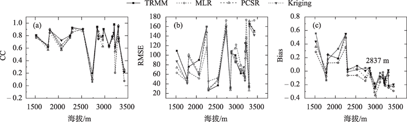
利用多元线性回归模型(MLR)、主成分逐步回归分析模型(PCSR)、克里金插值法(Kriging),将青海湖流域及周边区域0.25°分辨率的TRMM 3B43降水数据降尺度至0.01°分辨率,并选取研究区范围内20个气象站点的实测降水数据,利用相关系数(CC)、均方根误差(RMSE)和相对偏差(Bias)对降尺度结果进行评价,以此选取更适用于研究区的降尺度方法。结果表明:(1) 基于 TRMM及3种降尺度方法获取的研究区降水空间分布具有一致性,年均及春、夏、秋季的降水量均表现为北部高,西部及西北部低,而冬季降水量表现为南部与西北部高,中部低。(2) 研究区降水量随着海拔的增高,以3800 m为界整体上呈现先升高后降低的趋势。(3) 精度评价的结果表明,年尺度上的Kriging精度表现最好;在空间上TRMM及3种降尺度数据在东部地区精度最优。在季尺度上,数据精度表现为PCSR>Kriging>TRMM>MLR;在月尺度上,PCSR数据精度最优。(4) 海拔对研究区内TRMM及3种降尺度数据的影响较小,但随着海拔的升高,遥感数据逐渐出现低估降水的现象,其可能原因在于降水的低估与微波降水率反演时对对流性降水的低估有关。综合降水空间分布一致性分析与精度评价,认为PCSR最适合于青海湖流域及周边区域的TRMM 3B43降水数据降尺度方法。
李炎坤,高黎明,张乐乐,吴雪晴,刘轩辰,祁闻. 青海湖流域及周边区域TRMM 3B43降水数据降尺度方法对比分析[J]. 干旱区研究, 2022, 39(6): 1706-1716.
LI Yankun,GAO Liming,ZHANG Lele,WU Xueqing,LIU Xuanchen,QI Wen. Comparison of downscaling methods for TRMM 3B43 precipitation data in the Qinghai Lake Basin and its surrounding areas[J]. Arid Zone Research, 2022, 39(6): 1706-1716.
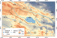
图1
研究区位置及气象站点分布"

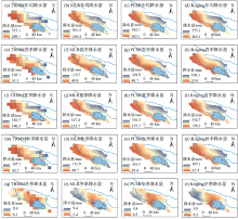
图2
青海湖流域降尺度结果空间分布"


图3
研究区海拔划分(a)及降水量随海拔的变化(b)"
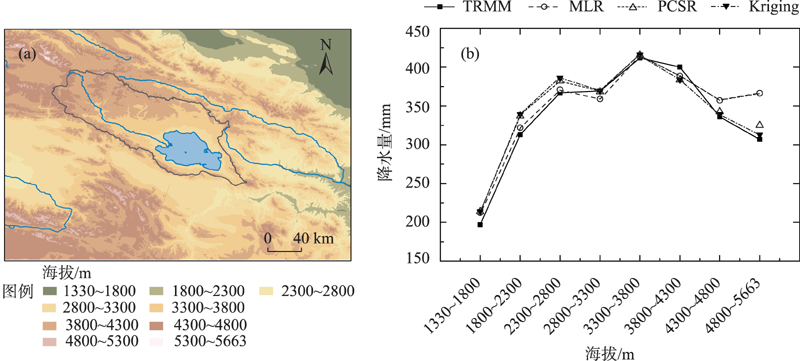

图4
实测降水量与TRMM数据及其降尺度数据年均散点图"


图5
年尺度上TRMM、MLR、PCSR和Kriging的CC(a~d)、PCSR(e~h)和Bias(i~l)的空间分布"
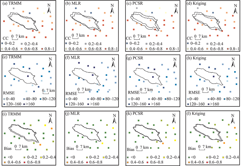
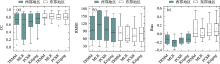
图6
年尺度上TRMM及3种降尺度数据在东西部地区的精度评价箱线图对比"
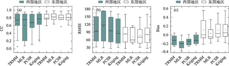

图7
TRMM数据及降尺度季均数据精度对比"
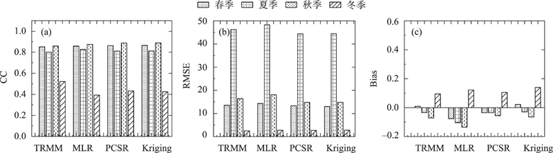
图8
TRMM原始月降水量、降尺度月降水量与实测月降水量散点图"

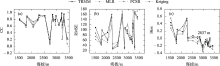
图9
各站点海拔与格点数据精度评价指标统计"
| [1] | 沈思民, 赵军, 刘佳茹, 等. 祁连山TRMM降水数据降尺度不同方法比较研究[J]. 山地学报, 2019, 37(6): 923-931. |
| [ Shen Simin, Zhao Jun, Liu Jiaru, et al. Comparative study on different downscaling methods of TRMM satellite precipitation data over the Qilian Mountains, China[J]. Mountain Research, 2019, 37(6): 923-931. ] | |
| [2] | 张乐乐, 高黎明, 陈克龙. 高分辨率遥感降水资料在青海湖流域及周边区域的适用性评价[J]. 水文, 2020, 40(5): 15-21. |
| [ Zhang Lele, Gao Liming, Chen Kelong. Applicability evaluation of high-resolution remote sensing precipitation data in Qinghai Lake basin and surrounding areas[J]. Journal of China Hydrology, 2020, 40(5): 15-21. ] | |
| [3] |
Ma Y, Tang G, Long D, et al. Similarity and error intercomparison of the GPM and its predecessor-TRMM multisatellite precipitation analysis using the best available hourly gauge network over the Tibetan Plateau[J]. Remote Sensing, 2016, 8(7): 569. ]
doi: 10.3390/rs8070569 |
| [4] | 袁飞, 赵晶晶, 任立良, 等. TRMM多卫星测雨数据在赣江上游径流模拟中的应用[J]. 天津大学学报: 自然科学与工程技术版, 2013, 46(7): 611-616. |
| [ Yuan Fei, Zhao Jingjing, Ren Liliang, et al. Application of TRMM multi-satellite rainfall data in runoff simulation of the upper reaches of Ganjiang River[J]. Journal of Tianjin University: Science and Technology, 2013, 46(7): 611-616. ] | |
| [5] | 窦世卿, 张寒博, 徐勇, 等. TRMM降水数据在长江流域的降尺度分析与校正[J]. 中国农业气象, 2021, 42(5): 377-389. |
| [ Dou Shiqing, Zhang Hanbo, Xu Yong, et al. Downscaling analysis and correction of TRMM precipitation data in the Yangtze River Basin[J]. Chinese Journal of Agrometeorology, 2021, 42(5): 377-389. ] | |
| [6] | 宋海清, 朱仲元, 李云鹏. 陆面同化及再分析降水资料在内蒙古地区的适用性[J]. 干旱区研究, 2021, 38(6): 1624-1636. |
| [ Song Haiqing, Zhu Zhongyuan, Li Yunpeng. Validation of land data assimilation and reanalysis precipitation datasets over Inner Mongolia[J]. Arid Zone Research, 2021, 38(6): 1624-1636. ] | |
| [7] | 杜军凯, 贾仰文, 李晓星, 等. 基于TRMM卫星降水的太行山区降水时空分布格局[J]. 水科学进展, 2019, 30(1): 1-13. |
| [ Du Junkai, Jia Yangwen, Li Xiaoxing, et al. Study on the spatial-temporal distribution pattern of precipitation in the Taihang Mountain region using TRMM data[J]. Advances in Water Science, 2019, 30(1): 1-13 ] | |
| [8] | 温婷婷, 郭英香, 董少睿, 等. 1979—2017年CRU, ERA5, CMFD格点降水数据在青藏高原适用性评估[J]. 干旱区研究, 2022, 39(3): 684-697. |
| [ Wen Tingting, Guo Yingxiang, Dong Shaorui, et al. Assessment of CRU, ERA5, CMFD grid precipitation data for the Tibetan Plateau from 1979 to 2017[J]. Arid Zone Research, 2022, 39(3): 684-697. ] | |
| [9] | 谷黄河, 余钟波, 杨传国, 等. 卫星雷达测雨在长江流域的精度分析[J]. 水电能源科学, 2010, 20(8): 3-6. |
| [ Gu Huanghe, Yu Zhongbo, Yang Chuanguo, et al. Accuracy analysis of satellite radar rain measurement in the Yangtze basin[J]. Water Resource And Power, 2010, 20(8): 3-6. ] | |
| [10] | 崔路明, 王思梦, 刘轶欣, 等. TRMM和GPM卫星降水数据在中国三大流域的降尺度对比研究[J]. 长江流域资源与环境, 2021, 30(6): 1317-1328. |
| [ Cui Luming, Wang Simeng, Liu Yixin, et al. Comparative study on downscaling of TRMM and GPM satellite precipitation data in three major river basins in China[J]. Resources and Environment in The Yangtze Basin, 2021, 30(6): 1317-1328. ] | |
| [11] | 孙铭悦, 吕海深, 朱永华, 等. 2套气象数据在资料缺乏地区的适用性评估——以呼图壁河流域为例[J]. 干旱区研究, 2022, 39(1): 94-103. |
| [ Sun Mingyue, Lv Haishen, Zhu Yonghua, et al. Applicability assessment of two meteorological datasets in areas lacking data with the Hutubi River Basin as an example[J]. Arid Zone Research, 2022, 39(1): 94-103. ] | |
| [12] | 盛夏, 石玉立, 丁海勇. 青藏高原GPM降水数据空间降尺度研究[J]. 遥感技术与应用, 2021, 36(3): 571-580. |
| [ Sheng Xia, Shi Yuli, Ding Haiyong. Spatial Downscaling of GPM Precipitation over the Tibetan Plateau[J]. Remote Sensing Technology and Application, 2021, 36(3): 571-580. ] | |
| [13] | 宁珊, 张正勇, 刘琳, 等. TRMM偏最小二乘降尺度降水模型在新疆不同地貌的适应性[J]. 农业工程学报, 2020, 36(12): 99-109. |
| [ Ning Shan, Zhang Zhengyong, Liu Lin, et al. Adaptability of precipitation estimation method based on TRMM data combined with partial least squares downscaling in different landforms of Xinjiang, China[J]. Transactions of the Chinese Society of Agricultural Engineering, 2020, 36(12): 99-109. ] | |
| [14] | Zhang T, Yang Y, Dong Z, et al. A multiscale assessment of three satellite precipitation products (TRMM, CMORPH, and PERSIANN) in the Three Gorges Reservoir Area in China[J]. Advances in Meteorology, 2021, 9979216: 1-27. |
| [15] |
Adler R F, Sapiano M R P, Huffman G J, et al. The Global Precipitation Climatology Project (GPCP) monthly analysis (new version 2.3) and a review of 2017 global precipitation[J]. Atmosphere, 2018, 9(4): 138.
doi: 10.3390/atmos9040138 |
| [16] | 李麒崙, 张万昌, 易路, 等. GPM与TRMM 降水数据在中国大陆的精度评估与对比[J]. 水科学进展, 2018, 29(3): 303-313. |
| [ Li Qilun, Zhang Wanchang, Yi Lu, et al. Accuracy evaluation and comparison of GPM and TRMM precipitation product over Mainland China[J]. Advances in Water Science, 2018, 29(3): 303-313. ] | |
| [17] |
Dhib S, Chaney N, Mannaerts C M, et al. Comparison of two bias correction methods for TRMM 3B42 satellite daily rainfall estimates over Northern Tunisia[J]. Arabian Journal of Geosciences, 2021, 14(7): 1-18.
doi: 10.1007/s12517-020-06304-8 |
| [18] |
刘江涛, 徐宗学, 赵焕, 等. 不同降水卫星数据反演降水量精度评价——以雅鲁藏布江流域为例[J]. 高原气象, 2019, 38(2): 386-396.
doi: 10.7522/j.issn.1000-0534.2018.00092 |
|
[ Liu Jiangtao, Xu Zongxue, Zhao Huan, et al. Accuracy assessment for two satellite precipitation products: Case studies in the Yarlung Zangbo River Basin[J]. Plateau Meteorology, 2019, 38(2): 386-396. ]
doi: 10.7522/j.issn.1000-0534.2018.00092 |
|
| [19] |
Prakash S, Mitra A K, AghaKouchak A, et al. A preliminary assessment of GPM-based multi-satellite precipitation estimates over a monsoon dominated region[J]. Journal of Hydrology, 2018, 556: 865-876.
doi: 10.1016/j.jhydrol.2016.01.029 |
| [20] |
Elnashar A, Zeng H, Wu B, et al. Downscaling TRMM monthly precipitation using google earth engine and google cloud computing[J]. Remote Sensing, 2020, 12(23): 3860.
doi: 10.3390/rs12233860 |
| [21] | 范雪薇, 刘海隆. 天山山区 TRMM 降水数据的空间降尺度研究[J]. 自然资源学报, 2018, 33(3): 478-488. |
| [ Fan Xuewei, Liu Hailong. Downscaling method of TRMM satellite precipitation data over the Tianshan Mountains[J]. Journal of Natural Resources, 2018, 33(3): 478-488. ] | |
| [22] | 张寒博, 窦世卿, 温颖, 等. 遥感降水数据空间降尺度及干旱时空监测[J]. 水土保持学报, 2022, 36(1): 153-160. |
| [ Zhang Hanbo, Dou Shiqing, Wen Ying, et al. Spatial downscaling of remote sensing precipitation data and spatiotemporal monitoring of drought[J]. Journal of Soil and Water Conservation, 2022, 36(1): 153-160. ] | |
| [23] | 李豪, 雷苑, 李鹏, 等. 复杂地形下 TRMM 降水数据的降尺度研究: 以四川省为例[J]. 中国农业气象, 2019, 40(10): 607-619. |
| [ Li Hao, Lei Yuan, Li Peng, et al. Downscaling of TRMM precipitation data under complex terrain: A case study of Sichuan Province[J]. Chinese Journal of Agrometeorology, 2019, 40(10): 607-619. ] | |
| [24] | 徐彬仁, 魏瑗瑗. 基于随机森林算法对青藏高原 TRMM 降水数据进行空间统计降尺度研究[J]. 国土资源遥感, 2018, 30(3): 181-188. |
| [ Xu Binren, Wei Yuanyuan. Spatial statistics of TRMM precipitation in the Tibetan Plateau using random forest algorithm[J]. Remote Sensing for Land & Resources, 2018, 30(3): 181-188. ] | |
| [25] |
Ghorbanpour A K, Hessels T, Moghim S, et al. Comparison and assessment of spatial downscaling methods for enhancing the accuracy of satellite-based precipitation over Lake Urmia Basin[J]. Journal of Hydrology, 2021, 596: 126055.
doi: 10.1016/j.jhydrol.2021.126055 |
| [26] | 高黎明, 张乐乐, 陈克龙, 等. 青海湖流域高寒湿地光合有效辐射特征[J]. 干旱区研究, 2018, 35(1): 50-56. |
| [ Gao Liming, Zhang Lele, Chen Kelong, et al. Characteristics of the photosynthetically active radiation in the alpine wetland, Qinghai lake watershed[J]. Arid Zone Research, 2018, 35(1): 50-56. ] | |
| [27] | 刘彩红, 王朋岭, 温婷婷, 等. 1960—2019 年黄河源区气候变化时空规律研究[J]. 干旱区研究, 2021, 38(2): 293-302. |
| [ Liu Caihong, Wang Pengling, Wen Tingting, et al. Spatio-temporal characteristics of climate change in the Yellow River source area from 1960 to 2019[J]. Arid Zone Research, 2021, 38(2): 293-302. ] | |
| [28] |
俞晓琴, 孟先强, 吴华武, 等. 青海湖流域有色可溶性有机物来源与特征分析[J]. 环境科学, 2022, 43(2): 826-836.
doi: 10.1021/es802638z |
|
[ Yu Xiaoqin, Meng Xianqiang, Wu Huawu, et al. Source and characteristics analysis of colored soluble organic matter in Qinghai Lake Basin[J]. Environmental Science, 2022, 43(2): 826-836. ]
doi: 10.1021/es802638z |
|
| [29] | 高晨轩. 利用多源卫星测高数据监测青海湖水位变化[D]. 兰州: 兰州交通大学, 2021. |
| [ Gao Chenxuan. Using Multi-source Satellite Altimeter Data to Monitor the Water Level Change of Qinghai Lake[D]. Lanzhou: Lanzhou Jiaotong University, 2021. ] | |
| [30] | Tang L, Duan X, Kong F, et al. Influences of climate change on area variation of Qinghai Lake on Qinghai-Tibetan Plateau since 1980s[J]. Scientific Reports, 2018, 8(1): 1-7. |
| [31] | 张晶, 鄂崇毅, 许乃军, 等. 青海湖流域气候变化对湖泊水位变化的影响[J]. 青海环境, 2021, 31(2): 71-75, 81. |
| [ Zhang Jing, E Chongyi, Xu Naijun, et al. Impact of climate change in Qinghai Lake Basin on lake water level change[J]. Journal of Qinghai Environment, 2021, 31(2): 71-75, 81. ] | |
| [32] | 王志刚, 曹生奎, 曹广超. 近15年来青海湖流域气温、降水变化对植被物候驱动分析[J]. 水土保持研究, 2022, 29(1): 249-255. |
| [ Wang Zhigang, Cao Shengkui, Cao Guangchao. Analysis on the drive of temperature and precipitation changes to vegetation phenology of the Qinghai Lake Basin in the past 15 years[J]. Research of Soil and Water Conservation, 2022, 29(1): 249-255. ] | |
| [33] | 姬凯, 王士新, 左洪超, 等. 东亚副热带急流经向位置对中国西北东部盛夏降水的影响[J]. 干旱区研究, 2020, 37(1): 10-17. |
| [ Ji Kai, Wang Shixin, Zuo Hongchao, et al. Effect of meridional position of East Asian subtropical jet on midsummer precipitation in eastern part of Northwest China[J]. Arid Zone Research, 2020, 37(1): 10-17. ] | |
| [34] | 杨昭明, 张调风. 1961—2017 年青藏高原东北部雨季降水量变化及其贡献度分析[J]. 干旱区研究, 2021, 38(1): 22-28. |
| [ Yang Zhaoming, Zhang Tiaofeng. Analysis of precipitation change and its contribution in the rainy season in the northeast Qinghai-Tibet Plateau from 1961 to 2017[J]. Arid Zone Research, 2021, 38(1): 22-28. ] | |
| [35] | 卢新玉, 魏鸣, 王秀琴, 等. TRMM-3B43降水产品在新疆地区的适用性研究[J]. 国土资源遥感, 2016, 28(3): 166-173. |
| [ Lu Xinyu, Wei Ming, Wang Xiuqin, et al. Applicability research on TRMM-3B43 precipitation over Xinjiang[J]. Remote Sensing for Land & Resources, 2016, 28(3): 166-173. ] | |
| [36] |
Xu R, Tian F, Yang L, et al. Ground validation of GPM IMERG and TRMM 3B42V7 rainfall products over southern Tibetan Plateau based on a high-density rain gauge network[J]. Journal of Geophysical Research: Atmospheres, 2017, 122(2): 910-924.
doi: 10.1002/2016JD025418 |
| [37] |
张乐乐, 高黎明, 赵林, 等. 降水观测误差修正研究进展[J]. 地球科学进展, 2017, 32(7): 723-730.
doi: 10.11867/j.issn.1001-8166.2017.07.0723 |
|
[ Zhang Lele, Gao Liming, Zhao Lin, et al. Review on correction of errors in precipitation measurement[J]. Advances in Earth Science, 2017, 32(7): 723-730. ]
doi: 10.11867/j.issn.1001-8166.2017.07.0723 |
|
| [38] |
Shi Y, Song L. Spatial downscaling of monthly TRMM precipitation based on EVI and other geospatial variables over the Tibetan Plateau from 2001 to 2012[J]. Mountain Research and Development, 2015, 35(2): 180-194.
doi: 10.1659/MRD-JOURNAL-D-14-00119.1 |
| [39] | 何晓波, 叶柏生, 丁永建. 青藏高原唐古拉山区降水观测误差修正分析[J]. 水科学进展, 2009, 20(3): 403-408. |
| [ He Xiaobo, Ye Baisheng, Ding Yongjian. Bias correction for precipitation mesuament in Tanggula Mountain Tibetan Plateau[J]. Advances in Water Science, 2009, 20(3): 403-408. ] | |
| [40] | 吴建峰, 陈阿林, 嵇涛, 等. TRMM 降水数据在复杂山地的精度评估——以重庆市为例[J]. 水土保持通报, 2014, 34(4): 201-207. |
| [ Wu Jianfeng, Chen Alin, Ji Tao, et al. Accuracy evaluation of tropical rainfall measuring mission [recipitation data in complex mountainous areas: Taking Chongqing City as an example[J]. Bulletin of Soil and Water Conservation, 2014, 34(4): 201-207. ] | |
| [41] | 李琼, 杨梅学, 万国宁, 等. TRMM 3B43降水数据在黄河源区的适用性评价[J]. 冰川冻土, 2016, 38(3): 620-633. |
| [ Li Qiong, Yang Meixue, Wan Guoning, et al. Analysis of the accuracy of TRMM 3B43 precipitation data in the source region of the Yellow River[J]. Journal of Glaciology and Geocryology, 2016, 38(3): 620-633. ] | |
| [42] |
Sapiano M R P, Arkin P A. An intercomparison and validation of high-resolution satellite precipitation estimates with 3-hourly gauge data[J]. Journal of Hydrometeorology, 2009, 10(1): 149-166.
doi: 10.1175/2008JHM1052.1 |
| [43] | Ren W, Yao T, Yang X, et al. Implications of variations in δ18O and δD in precipitation at Madoi in the eastern Tibetan Plateau[J]. Quaternary International, 2013, 313: 56-61. |
| [1] | 张嘉琪, 刘招, 韩忠青, 王丽霞, 张晋霞, 岳甲寅, 管子隆. 气候变化下泾河流域蓝绿水变化趋势及预测[J]. 干旱区研究, 2024, 41(12): 2045-2055. |
| [2] | 张音, 孙从建, 刘庚, 钞锦龙, 耿甜伟. 近20 a塔里木河流域山区NDSI对气候变化的响应[J]. 干旱区研究, 2024, 41(10): 1639-1648. |
| [3] | 李永广, 苑广辉. 青海湖流域不同下垫面类型对地表温度的生物物理影响[J]. 干旱区研究, 2024, 41(1): 24-35. |
| [4] | 薛智暄, 张丽, 王新军, 李永康, 张冠宏, 李沛尧. 古尔班通古特沙漠SMAP土壤水分产品降尺度分析[J]. 干旱区研究, 2023, 40(4): 583-593. |
| [5] | 吴雪晴, 张乐乐, 高黎明, 李炎坤, 刘轩辰. 青海湖流域NPP动态变化及驱动力[J]. 干旱区研究, 2023, 40(11): 1824-1832. |
| [6] | 杨紫唯,车子涵,刘芙梅,陈克龙. 降水梯度对青海湖河源湿地温室气体排放日变化的影响[J]. 干旱区研究, 2022, 39(3): 754-766. |
| [7] | 李永康,王新军,马燕飞,胡贵锋,桂海月,张冠宏. 基于Catboost的AMSR-2半经验地表温度降尺度[J]. 干旱区研究, 2021, 38(6): 1637-1649. |
| [8] | 尉迟文思,苗恒录,王星天,高天明,邬佳宾. 阴山北麓荒漠草原干旱气象因子分析[J]. 干旱区研究, 2021, 38(5): 1327-1334. |
| [9] | 白壮壮, 崔建新, 丁晓辉. 1986—2015年鄂尔多斯高原沙漠化及其驱动因素研究[J]. 干旱区研究, 2020, 37(3): 749-. |
| [10] | 李晓菲, 徐长春, 李路, 宋佳, 张喜成. 21世纪开都-孔雀河流域未来气候变化情景预估[J]. 干旱区研究, 2019, 36(3): 556-566. |
| [11] | 韩鹏飞,王旭升,胡晓农,蒋小伟,周燕怡. 巴丹吉林沙漠湖泊水面蒸发与气象要素的动态关系[J]. 干旱区研究, 2018, 35(5): 1012-1020. |
| [12] | 高黎明, 张乐乐, 陈克龙, 毛亚辉. 青海湖流域高寒湿地光合有效辐射特征[J]. 干旱区研究, 2018, 35(01): 50-56. |
| [13] | 李成秀, 李小雁, 杨太保, 李岳坦. 青海湖流域沙柳河草甸群落结构与数量特征[J]. 干旱区研究, 2013, 30(6): 1028-1035. |
| [14] | 章杰, 白红英, 袁博, 马新萍. 秦岭地区气温变化统计降尺度研究[J]. 干旱区研究, 2013, 30(2): 322-328. |
| [15] | 钞振华. 中国西部地区气温资料的统计降尺度研究[J]. 干旱区研究, 2011, 28(5): 879-884. |
|
||