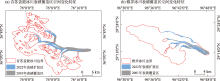
| [1] |
Cogley J G, Hock R, Rasmussen L A, et al. Glossary of glacier mass balance and related terms[J]. Arctic Antarctic and Alpine Research, 2012, 44(2): 256-258.
|
| [2] |
Hewitt K. Rock avalanches that travel onto glaciers and related developments, Karakoram Himalaya, Inner Asia[J]. Geomorphology, 2009, 103(1): 66-79.
|
| [3] |
张勇, 刘时银, 王欣. 青藏高原及周边冰川区表碛影响研究进展[J]. 冰川冻土, 2022, 44(3): 900-913.
doi: 10.7522/j.issn.1000-0240.2022.0086
|
|
[Zhang Yong, Liu Shiyin, Wang Xin. Debris-cover effect in the Tibetan Plateau and surroundings: A review[J]. Journal of Glaciology and Geocryology, 2022, 44(3): 900-913.]
|
| [4] |
Cauvy-Fraunié S, Andino P, Espinosa R, et al. Ecological responses to experimental glacier-runoff reduction in alpine rivers[J]. Nature Communications, 2016, 7(1): 12025.
|
| [5] |
Millan R, Mouginot J, Rabatel A, et al. Ice velocity and thickness of the world’s glaciers[J]. Nature Geoscience, 2022, 15(2): 124-129.
|
| [6] |
Zemp M, Huss M, Thibert E, et al. Global glacier mass changes and their contributions to sea-level rise from 1961 to 2016[J]. Nature, 2019, 568(7752): 382-386.
|
| [7] |
Hall D K, Riggs G A, Salomonson V V. Development of methods for mapping global snow cover using moderate resolution imaging spectroradiometer data[J]. Remote Sensing of Environment, 1995, 54(2): 127-140.
|
| [8] |
陈逸青, 段克勤, 石培宏, 等. 1990—2020年帕米尔高原无表碛覆盖冰川变化态势研究——基于Google Earth Engine平台[J]. 冰川冻土, 2024, 46(3): 742-753.
doi: 10.7522/j.issn.1000-0240.2024.0061
|
|
[Chen Yiqing, Duan Keqin, Shi Peihong, et al. Change trend of debris-free glaciers in the Pamir based on Google Earth Engine from 1990 to 2020[J]. Journal of Glaciology and Geocryology, 2024, 46(3): 742-753.]
doi: 10.7522/j.issn.1000-0240.2024.0061
|
| [9] |
黄晓然, 包安明, 郭浩, 等. 近20 a中国天山东段典型冰川变化及其气候响应[J]. 干旱区研究, 2017, 34(4): 870-880.
|
|
[Huang Xiaoran, Bao Anming, Guo Hao, et al. Change of typical glaciers and its response to meteorological factors in the Eastern Tianshan Mountains in China in recent 20 years[J]. Arid Zone Research, 2017, 34(4): 870-880.]
|
| [10] |
Zhang M, Wang X H, Shi C L, et al. Automated glacier extraction index by optimization of Red/SWIR and NIR/SWIR ratio index for glacier mapping using Landsat imagery[J]. Water, 2019, 11(6): 1223.
|
| [11] |
都伟冰, 李均力, 包安明, 等. 高山冰川多时相多角度遥感信息提取方法[J]. 测绘学报, 2015, 44(1): 59-66.
doi: 10.11947/j.AGCS.2015.20130514
|
|
[Du Weibing, Li Junli, Bao Anming, et al. Information extraction method of alpine glaciers with multitemporal and multiangle remote sensing[J]. Acta Geodactica et Cartographica Sinica, 2015, 44(1): 59-66.]
|
| [12] |
Huang L, Li Z, Tian B S, et al. Classification and snow line detection for glacial areas using the polarimetric SAR image[J]. Remote Sensing of Environment, 2011, 115(7): 1721-1732.
|
| [13] |
Walter V. Object-based classification of remote sensing data for change detection[J]. ISPRS Journal of Photogrammetry and Remote Sensing, 2004, 58(3-4): 225-238.
|
| [14] |
怀保娟, 李忠勤, 孙美平, 等. 多种遥感分类方法提取冰川边界探讨——以喀纳斯河源地区为例[J]. 干旱区研究, 2013, 30(2): 372-377.
|
|
[Huai Baojuan, Li Zhongqin, Sun Meiping, et al. Discussion on RS methods for glacier outline detection——A case study in headwaters of the Kanas River[J]. Arid Zone Research, 2013, 30(2): 372-377.]
|
| [15] |
Shukla A, Arora M K, Gupta R P. Synergistic approach for mapping debris-covered glaciers using optical-thermal remote sensing data with inputs from geomorphometric parameters[J]. Remote Sensing of Environment, 2010, 114(7): 1378-1387.
|
| [16] |
雷赛月, 方立, 李辰德, 等. 改进光学卫星图像中表碛覆盖型冰川区域提取算法[J]. 计算机工程, 2025, 2(51): 269-277.
|
|
[Lei Saiyue, Fang Li, Li Chende, et al. Improving the algorithm for extracting debris-covered glaciers in optical satellite images[J]. Computer Engineering, 2025, 2(51): 269-277.]
|
| [17] |
薛娇, 姚晓军, 张聪, 等. 表碛覆盖型冰川的提取方法及变化[J]. 冰川冻土, 2022, 44(5): 1653-1664.
doi: 10.7522/j.issn.1000-0240.2022.0145
|
|
[Xue Jiao, Yao Xiaojun, Zhang Cong, et al. Extraction method and change of debris-covered glaciers[J]. Journal of Glaciology and Geocryology, 2022, 44(5): 1653-1664.]
doi: 10.7522/j.issn.1000-0240.2022.0145
|
| [18] |
Holobâcă I-H, Tielidze L G, Ivan K, et al. Multi-sensor remote sensing to map glacier debris cover in the Greater Caucasus, Georgia[J]. Journal of Glaciology, 2021, 67(264): 685-696.
|
| [19] |
周建民, 李震, 邢强. 基于雷达干涉失相干特性提取冰川边界方法研究[J]. 冰川冻土, 2010, 32(1): 133-138.
|
|
[Zhou Jianmin, Li Zhen, Xing Qiang. Deriving glacier border information based on analysis of decorrelation in SAR interferometry[J]. Journal of Glaciology and Geocryology, 2010, 32(1): 133-138.]
|
| [20] |
李若楠, 李均力, 李爽爽, 等. 基于Sentinel-2的依连哈比尔尕冰川变化监测[J]. 干旱区研究, 2024, 41(6): 940-950.
doi: 10.13866/j.azr.2024.06.04
|
|
[Li Ruonan, Li Junli, Li Shuangshuang, et al. Monitoring the glacier changes in Yilian Habirga Mountain using Sentinel-2 data[J]. Arid Zone Research, 2024, 41(6): 940-950.]
doi: 10.13866/j.azr.2024.06.04
|
| [21] |
Yousuf B, Shukla A, Arora M K, et al. On drivers of subpixel classification accuracy—An example from glacier facies[J]. IEEE Journal of Selected Topics in Applied Earth Observations and Remote Sensing, 2020, 13(1): 601-608.
|
| [22] |
Aftab A K, Akhtar J, Dostdar H, et al. Machine-learning algorithms for mapping debris-covered glaciers: The Hunza Basin case study[J]. IEEE Access, 2020, 8(1): 12725-12734.
|
| [23] |
Xie Z Y, Asari V K, Haritashya U K. Evaluating deep-learning models for debris-covered glacier mapping[J]. Applied Computing and Geosciences, 2021, 12(1): 100071.
|
| [24] |
Yang S J, Wang F T, Xie Y D, et al. Delineation evaluation and variation of debris-covered glaciers based on the multi-source remote sensing images, Take glaciers in the eastern Tomur Peak region for example[J]. Remote Sensing, 2023, 15(10): 2575.
|
| [25] |
Racoviteanu A, Williams M W. Decision tree and texture analysis for mapping debris-covered glaciers in the Kangchenjunga area, Eastern Himalaya[J]. Remote Sensing, 2012, 4(10): 3078-3109.
|
| [26] |
Zhao Q, Yu L, Li X C, et al. Progress and trends in the application of Google Earth and Google Earth Engine[J]. Remote Sensing, 2021, 13(18): 3778.
|
| [27] |
Amani M, Mahdavi S, Afshar M, et al. Canadian wetland inventory using Google Earth Engine: The first map and preliminary results[J]. Remote Sensing, 2019, 11(7): 842.
|
| [28] |
喻彩丽, 陆健强, 窦旭峰, 等. 基于GEE的多源遥感影像青梅种植信息提取[J]. 江苏农业学报, 2024, 40(8): 1455-1463.
|
|
[Yu Caili, Lu Jianqiang, Dou Xufeng, et al. Extraction of greengage planting information from multi-source remote sensing images based on GEE[J]. Jiangsu Journal of Agricultural Sciences, 2024, 40(8): 1455-1463.]
|
| [29] |
马东岭, 刘卫星, 张春红. 基于谷歌地球引擎和分形理论的黄河三角洲土地利用空间结构研究[J]. 土壤, 2024, 56(3): 655-665.
|
|
[Ma Dongling, Liu Weixing, Zhang Chunhong. Study on land use spatial structure based on Google Earth Engine and fractal theory: A case study of ecological function reserve in Yellow River Delta[J]. Soils, 2024, 56(3): 655-665.]
|
| [30] |
Bevington A R, Menounos B. Accelerated change in the glaciated environments of western Canada revealed through trend analysis of optical satellite imagery[J]. Remote Sensing of Environment, 2022, 270(1): 112862.
|
| [31] |
Hu M C, Zhou G S, Lv X M, et al. A new automatic extraction method for glaciers on the Tibetan Plateau under clouds, shadows and snow cover[J]. Remote Sensing, 2022, 14(13): 3084.
|
| [32] |
Huang L, Li Z, Zhou J M, et al. An automatic method for clean glacier and nonseasonal snow area change estimation in High Mountain Asia from 1990 to 2018[J]. Remote Sensing of Environment, 2021, 258(1): 112376.
|
| [33] |
Ali A, Dunlop P, Coleman S, et al. Glacier area changes in Novaya Zemlya from 1986-89 to 2019-21 using object-based image analysis in Google Earth Engine[J]. Journal of Glaciology, 2023, 69(277): 1305-1316.
|
| [34] |
刘时银, 姚晓军, 郭万钦, 等. 基于第二次冰川编目的中国冰川现状[J]. 地理学报, 2015, 70(1): 3-16.
doi: 10.11821/dlxb201501001
|
|
[Liu Shiyin, Yao Xiaojun, Guo Wanqin, et al. The contemporary glaciers in China based on the Second Chinese Glacier Inventory[J]. Acta Geographica Sinica, 2015, 70(1): 3-16.]
doi: 10.11821/dlxb201501001
|
| [35] |
Achanta R, Susstrunk S. Superpixels and polygons using simple non-iterative clustering[C]// Proceedings of the IEEE Conference on Computer Vision and Pattern Recognition. New York: IEEE Computer Society, 2017: 4651-4660.
|
| [36] |
裴欢, 孙天娇, 王晓妍. 基于 Landsat 8 OLI 影像纹理特征的面向对象土地利用/覆盖分类[J]. 农业工程学报, 2018, 34(2): 248-255.
|
|
[Pei Huan, Sun Tianjiao, Wang Xiaoyan. Object-oriented land use/cover classification based on texture features of Landsat 8 OLI image[J]. Transactions of the Chinese Society of Agricultural Engineering, 2018, 34(2): 248-255.]
|
| [37] |
Paul F, Huggel C, Kääb A. Combining satellite multispectral image data and a digital elevation model for mapping debris-covered glaciers[J]. Remote Sensing of Environment, 2004, 89(4): 510-518.
|
| [38] |
Östrem G. Ice melting under a thin layer of moraine, and the existence of ice cores in moraine ridges[J]. Geografiska Annaler, 1959, 41(4): 228-230.
|
| [39] |
Zhuang L C, Ke C Q, Cai Y, et al. Measuring glacier changes in the Tianshan Mountains over the past 20 years using Google Earth Engine and machine learning[J]. Journal of Geographical Sciences, 2023, 33(9): 1939-1964.
doi: 10.1007/s11442-023-2160-4
|
| [40] |
许艾文. 近40年中国喀喇昆仑山冰川变化的遥感监测[D]. 兰州: 兰州大学, 2017.
|
|
[Xu Aiwen. Monitoring Glacier Change Based on Remote Sensing in China Karakoram for the Last Four Decades[D]. Lanzhou: Lanzhou University, 2017.]
|
| [41] |
赵晋彪. 藏东南地区冰川变化与运动特征研究[D]. 安徽: 安徽理工大学, 2024.
|
|
[Zhao Jinbiao. Study on Characteristics of Glacier Change and Movement in Southeast Xizang[D]. Anhui: Anhui University of Science and Technology, 2024.]
|
 ), 王霞迎1,2,3,4, 夏元平1,2,3,4(