干旱区研究 ›› 2024, Vol. 41 ›› Issue (7): 1249-1258.doi: 10.13866/j.azr.2024.07.16 cstr: 32277.14.AZR.20240716
• 生态与环境 • 上一篇
杨锁华1( ), 李丽2(), 马江德3, 郭文霞2
收稿日期:2024-03-06
修回日期:2024-04-10
出版日期:2024-07-15
发布日期:2024-08-01
通讯作者:
李丽. E-mail: 18966717126@163.com作者简介:杨锁华(1993-),女,硕士,工程师,主要从事土地利用变化及国土空间规划方面的研究. E-mail: cugyangsh@163.com
基金资助:
YANG Suohua1(), LI Li2(), MA Jiangde3, GUO Wenxia2
Received:2024-03-06
Revised:2024-04-10
Published:2024-07-15
Online:2024-08-01
摘要:
基于陕西省1990年、2000年、2010年、2020年土地利用数据,采用土地利用变化图谱、土地转移矩阵、地形位及分布指数等方法,分析“三生空间”用地转型过程及梯度分异特征,对全省国土空间优化、国土资源管理及耕地保护等具有重要意义。结果表明:(1) 陕西省生产、生活用地主要分布在关中地区,生态用地主要分布在陕北地区和陕南山区。(2) 1990—2020年土地利用转型较为剧烈,农业生产、其他生态用地面积净减少,工业生产、城镇和农村生活、林地生态、草地生态、水域生态用地面积净增加;变化剧烈程度呈现“陕北地区>关中地区>陕南山区”的空间分布特征。(3) 随着地形位增加,主导地类由“农业生产用地”—“农业生产用地、草地生态用地”—“林地、草地生态用地”过渡;农业和工业生产用地、城镇和农村生活用地、水域生态用地面积占比逐渐减少,林地生态用地占比逐渐增加,草地、其他生态用地占比先增后减。
杨锁华, 李丽, 马江德, 郭文霞. “三生空间”视角下陕西省1990—2020年土地利用转型及梯度效应[J]. 干旱区研究, 2024, 41(7): 1249-1258.
YANG Suohua, LI Li, MA Jiangde, GUO Wenxia. Land use transitions and its terrain gradient effects based on production-living-ecological spaces in Shaanxi Province during 1990-2020[J]. Arid Zone Research, 2024, 41(7): 1249-1258.
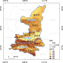
图1
陕西省区划及地形梯度划分"

表1
土地利用主导功能分类"
| 一级地类 | 二级地类 | 对应土地分类系统二级地类 |
|---|---|---|
| 生产空间 | 农业生产用地 | 水田(11)、旱地(12) |
| 工业生产用地 | 工交建设用地(53) | |
| 生活用地 | 城镇生活用地 | 城镇用地(51) |
| 农村生活用地 | 农村居民用地(52) | |
| 生态空间 | 林地生态用地 | 有林地(21)、灌木林(22)、疏林地(23)、其他林地(24) |
| 草地生态用地 | 高覆盖度草地(31)、中覆盖度草地(32)、低覆盖度草地(33) | |
| 水域生态用地 | 河渠(41)、湖泊(42)、水库坑塘(43)、滩地(46) | |
| 其他生态用地 | 沙地(61)、戈壁(62)、盐碱地(63)、沼泽地(64)、裸土地(65)、裸岩石砾地(66)、其他未利用地(67) |
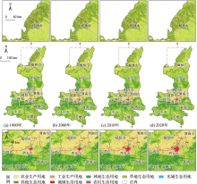
图2
陕西省1990—2020年“三生空间”类型分布"

表2
陕西省1990—2020年“三生空间”面积及变化"
| 类型 | 面积/km2 | 面积变化/km2 | 变化率/% | ||||||||||
|---|---|---|---|---|---|---|---|---|---|---|---|---|---|
| 1990年 | 2000年 | 2010年 | 2020年 | 1990—2000年 | 2000—2010年 | 2010—2020年 | 1990—2000年 | 2000—2010年 | 2010—2020年 | ||||
| 生产空间 | 农业生产用地 | 71773.5 | 71881.7 | 68175.6 | 66784.1 | 108.2 | -3706.1 | -1391.5 | 0.2 | -5.2 | -2.0 | ||
| 工业生产用地 | 109.3 | 128.1 | 393.6 | 1251.6 | 18.8 | 265.5 | 858.0 | 17.2 | 207.3 | 218.0 | |||
| 小计 | 71882.8 | 72009.8 | 68569.2 | 68035.7 | 127.0 | -3440.6 | -533.5 | 0.2 | -4.8 | -0.8 | |||
| 生活空间 | 城镇生活用地 | 423.4 | 551.9 | 872.5 | 1007.4 | 128.5 | 320.6 | 134.9 | 30.3 | 58.1 | 15.5 | ||
| 农村生活用地 | 2225.8 | 2465.7 | 3029.9 | 3023.5 | 239.9 | 564.2 | -6.4 | 10.8 | 22.9 | -0.2 | |||
| 小计 | 2649.2 | 3017.6 | 3902.4 | 4030.9 | 368.4 | 884.8 | 128.5 | 13.9 | 29.3 | 3.3 | |||
| 生态空间 | 林地生态用地 | 46154.9 | 46352.4 | 48026.4 | 48564.6 | 197.5 | 1674.0 | 538.2 | 0.4 | 3.6 | 1.1 | ||
| 草地生态用地 | 77116.9 | 77750.1 | 78871.4 | 78649.7 | 633.2 | 1121.3 | -221.7 | 0.8 | 1.4 | -0.3 | |||
| 水域生态用地 | 1691.6 | 1655.4 | 1656.3 | 1777.5 | -36.2 | 0.9 | 121.2 | -2.1 | 0.1 | 7.3 | |||
| 其他生态用地 | 6056.3 | 4766.4 | 4526.0 | 4493.3 | -1289.9 | -240.4 | -32.7 | -21.3 | -5.0 | -0.7 | |||
| 小计 | 131019.7 | 130524.3 | 133080.1 | 133485.1 | -495.4 | 2555.8 | 405.0 | -0.4 | 2.0 | 0.3 | |||
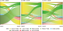
图3
陕西省1990—2000年、2000—2010年、2010—2020年土地利用转型趋势图"

表3
1990—2020年陕西省土地利用转移矩阵"
| 1990年 | 2020年 | ||||||||
|---|---|---|---|---|---|---|---|---|---|
| 农业生产用地 | 工业生产用地 | 城镇生活用地 | 农村生活用地 | 林地生态用地 | 草地生态用地 | 水域生态用地 | 其他生态用地 | 总计 | |
| 农业生产用地 | 63672.3 | 505.6 | 499.5 | 908.9 | 1604.5 | 4358.7 | 160.7 | 63.3 | 71773.5 |
| 工业生产用地 | 1.6 | 100.5 | 0.9 | 1.1 | 0.1 | 2.9 | 2.2 | 0.0 | 109.3 |
| 城镇生活用地 | 2.6 | 0.7 | 408.0 | 2.6 | 7.3 | 2.1 | 0.1 | 0.0 | 423.4 |
| 农村生活用地 | 95.6 | 4.3 | 43.4 | 2052.9 | 15.9 | 11.7 | 1.8 | 0.2 | 2225.8 |
| 林地生态用地 | 362.0 | 33.8 | 33.9 | 15.6 | 44786.7 | 865.9 | 12.6 | 44.4 | 46154.9 |
| 草地生态用地 | 2355.4 | 349.0 | 19.2 | 37.2 | 2063.4 | 72059.9 | 72.3 | 160.5 | 77116.9 |
| 水域生态用地 | 98.4 | 11.1 | 1.7 | 3.9 | 7.2 | 58.0 | 1506.8 | 4.5 | 1691.6 |
| 其他生态用地 | 196.2 | 246.6 | 0.8 | 1.3 | 79.5 | 1290.5 | 21.0 | 4220.4 | 6056.3 |
| 总计 | 66784.1 | 1251.6 | 1007.4 | 3023.5 | 48564.6 | 78649.7 | 1777.5 | 4493.3 | 205551.7 |
图4
1990—2020年陕西省土地利用变化图谱"

表4
陕西省不同地形位指数的土地利用结构及变化"
| 地形位指数 | 时间 | 农业生产用地 | 工业生产用地 | 城镇生活用地 | 农村生活用地 | 林地生态用地 | 草地生态用地 | 水域生态用地 | 其他生态用地 |
|---|---|---|---|---|---|---|---|---|---|
| 1级 | 2020年 | 15182.7 | 386.5 | 853.9 | 2050.2 | 510.8 | 1056.7 | 921.7 | 80.8 |
| 1990—2020年 | -1369.8 | 328.8 | 515.1 | 579.1 | 70.8 | -119.1 | 48.6 | -53.5 | |
| 2级 | 2020年 | 17674.9 | 639.0 | 116.2 | 734.4 | 3441.3 | 15713.6 | 562.2 | 3995.4 |
| 1990—2020年 | -725.7 | 614.1 | 62.0 | 189.2 | 328.9 | 950.1 | 14.0 | -1432.6 | |
| 3级 | 2020年 | 18829.4 | 182.7 | 24.9 | 167.2 | 10595.4 | 25765.1 | 196.9 | 336.2 |
| 1990—2020年 | -1520.6 | 168.6 | 10.3 | 31.2 | 789.4 | 595.2 | 15.4 | -89.5 | |
| 4级 | 2020年 | 12405.8 | 36.8 | 9.5 | 62.2 | 17974.1 | 25408.7 | 85.8 | 59.5 |
| 1990—2020年 | -1175.2 | 29.0 | 0.0 | 3.6 | 855.3 | 269.7 | 7.0 | 10.6 | |
| 5级 | 2020年 | 2691.3 | 6.6 | 2.9 | 9.5 | 16043.0 | 10705.6 | 10.9 | 21.4 |
| 1990—2020年 | -198.1 | 1.8 | -3.4 | -5.4 | 365.3 | -163.1 | 0.9 | 2.0 | |
| 总计 | 2020年 | 66784.1 | 1251.6 | 1007.4 | 3023.5 | 48564.6 | 78649.7 | 1777.5 | 4493.3 |
| 1990—2020年 | -4989.4 | 1142.3 | 584.0 | 797.7 | 2409.7 | 1532.8 | 85.9 | -1563.0 |
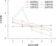
图5
地形位梯度上的土地利用变化分布指数"
| [1] |
龙花楼. 论土地利用转型与土地资源管理[J]. 地理研究, 2015, 34(9): 1607-1618.
doi: 10.11821/dlyj201509001 |
|
[Long Hualou. Land use transition and land management[J]. Geographical Research, 2015, 34(9): 1607-1618.]
doi: 10.11821/dlyj201509001 |
|
| [2] | 龙花楼. 土地利用转型的解释[J]. 中国土地科学, 2022, 36(4): 1-7. |
| [Long Hualou. Explanation of land use transitions[J]. China Land Science, 2022, 36(4): 1-7.] | |
| [3] |
胡守庚, 童陆亿, 龙花楼. 论土地利用转型潜力及其评价的理论框架[J]. 地理研究, 2019, 38(6): 1367-1377.
doi: 10.11821/dlyj020180421 |
|
[Hu Shougeng, Tong Luyi, Long Hualou. Land use transition potential and its assessment framework[J]. Geographical Research, 2019, 38(6): 1367-1377.]
doi: 10.11821/dlyj020180421 |
|
| [4] | 胡锦涛. 坚定不移沿着中国特色社会主义道路前进为全面建成小康社会而奋斗[N]. 人民日报, 2012-11-18 ( 1). |
| [Hu Jintao. Firmly march on the path of socialism with Chinese characteristics and strive to complete the building of a moderately prosperous society in all respects[N]. People’s Daily, 2012-11-18 ( 1).] | |
| [5] | 江曼琦, 刘勇. “三生”空间内涵与空间范围的辨析[J]. 城市发展研究, 2020, 27(4): 43-48, 61. |
| [Jiang Manqi, Liu Yong. Discussion on the concept definition and spatial boundary classification of “production-living-ecological” space[J]. Urban Development Studies, 2020, 27(4): 43-48, 61.] | |
| [6] |
杨清可, 段学军, 王磊, 等. 基于“三生空间”的土地利用转型与生态环境效应——以长江三角洲核心区为例[J]. 地理科学, 2018, 38(1): 97-106.
doi: 10.13249/j.cnki.sgs.2018.01.011 |
|
[Yang Qingke, Duan Xuejun, Wang Lei, et al. Land use transformation based on ecological-production-living spaces and associated eco-environment effects: A case study in the Yangtze River Delta[J]. Scientia Geographica Sinica, 2018, 38(1): 97-106.]
doi: 10.13249/j.cnki.sgs.2018.01.011 |
|
| [7] | 丁孝媛, 叶长盛. 环鄱阳湖城市群“三生”用地转型的生态环境效应及其地形梯度分析[J]. 水土保持研究, 2024, 31(1): 315-326. |
| [Ding Xiaoyuan, Ye Changsheng. Eco-environmental effects of ‘production-ecology-living’ land use transformation and the analysis of terrain gradient in Poyang Lake City Cluster[J]. Research of Soil and Water Conservation, 2024, 31(1): 315-326.] | |
| [8] | 杨朔, 郑晓筝, 赵国平. 关中平原城市群“三生”空间生态环境效应及影响因素研究[J]. 干旱区资源与环境, 2023, 37(9): 26-35. |
| [Yang Shuo, Zheng Xiaozheng, Zhao Guoping. Spatial ecological effects of ecological-production-living spaces in the Guanzhong Plain Urban Agglomeration and influencing factors[J]. Journal of Arid Land Resources and Environment, 2023, 37(9): 26-35.] | |
| [9] |
范清瑶, 夏卫生, 莫成鑫, 等. 基于“三生空间”的土地利用转型时空演变及其碳排放效应研究——以福建省为例[J]. 生态环境学报, 2023, 32(12): 2183-2193.
doi: 10.16258/j.cnki.1674-5906.2023.12.010 |
| [Fan Qingyao, Xia Weisheng, Mo Chengxin, et al. Study on transition of land use function and its carbon emission effect repose based on the conception of “production, living and ecological space”: A case study of Fujian Province[J]. Ecology and Environmental Sciences, 2023, 32(12): 2183-2193.] | |
| [10] | 刘莹, 耿文亮, 邵静文, 等. “三生空间”视角下土地利用变化与生态系统服务价值响应——以黄河下游地区为例[J]. 地域研究与开发, 2021, 40(4): 129-135. |
| [Liu Ying, Geng Wenliang, Shao Jingwen, et al. Land use change and ecosystem service value response from the perspective of “ecological-production-living Spaces”: A case study of the Lower Yellow River[J]. Areal Research and Development, 2021, 40(4): 129-135.] | |
| [11] |
勾蒙蒙, 刘常富, 李乐, 等. “三生空间”视角下三峡库区土地利用转型的生态系统服务价值效应[J]. 应用生态学报, 2021, 32(11): 3933-3941.
doi: 10.13287/j.1001-9332.202111.020 |
|
[Gou Mengmeng, Liu Changfu, Li Le, et al. Ecosystem service value effects of the Three Gorges Reservoir Area land use transformation under the perspective of “production-living-ecological” space[J]. Chinese Journal of Applied Ecology, 2021, 32(11): 3933-3941.]
doi: 10.13287/j.1001-9332.202111.020 |
|
| [12] | 刘宇, 傅伯杰. 黄土高原植被覆盖度变化的地形分异及土地利用/覆被变化的影响[J]. 干旱区地理, 2013, 36(6): 1097-1102. |
| [Liu Yu, Fu Bojie. Topographical variation of vegetation cover evolution and the impact of land use/cover change in the Loess Plateau[J]. Arid Land Geography, 2013, 36(6): 1097-1102.] | |
| [13] |
张学斌, 罗君, 石培基, 等. 格网尺度下张掖生态系统服务价值时空演变及地形梯度分异特征[J]. 应用生态学报, 2020, 31(2): 543-553.
doi: 10.13287/j.1001-9332.202002.007 |
|
[Zhang Xuebin, Luo Jun, Shi Peiji, et al. Spatial-temporal evolution pattern and terrain gradient differentiation of ecosystem service value in Zhangye, Northwest China at the grid scale[J]. Chinese Journal of Applied Ecology, 2020, 31(2): 543-553.]
doi: 10.13287/j.1001-9332.202002.007 |
|
| [14] | 刘涛, 侯兰功. 川北地形过渡带地形因子对土地利用与景观格局变化的影响[J]. 水土保持通报, 2020, 40(4): 75-82, 90. |
| [Liu Tao, Hou Langong. Effects of terrain factors on land use and landscape pattern change in terrain transition zone of northern Sichuan Province[J]. Bulletin of Soil and Water Conservation, 2020, 40(4): 75-82, 90.] | |
| [15] | 李京京, 吕哲敏, 石小平, 等. 基于地形梯度的汾河流域土地利用时空变化分析[J]. 农业工程学报, 2016, 32(7): 230-236. |
| [Li Jingjing, Lv Zhemin, Shi Xiaoping, et al. Spatiotemporal variations analysis for land use in Fen River Basin based on terrain gradient[J]. Transactions of the Chinese Society of Agricultural Engineering, 2016, 32(7): 230-236.] | |
| [16] | 孙丕苓, 许月卿, 王数. 环京津贫困带土地利用变化的地形梯度效应分析[J]. 农业工程学报, 2014, 30(14): 277-288. |
| [Sun Piling, Xu Yueqing, Wang Shu. Terrain gradient effect analysis of land use change in poverty area around Beijing and Tianjin[J]. Transactions of the Chinese Society of Agricultural Engineering, 2014, 30(14): 277-288.] | |
| [17] | 杨李玲, 和阳一丹, 唐红, 等. 云南红河流域土地利用变化的地形梯度效应及其功能分区[J]. 云南大学学报(自然科学版), 2024, 46(2): 276-287. |
| [Yang Liling, He Yangyidan, Tang Hong, et al. Terrain gradient effect and functional zoning of land use change in the Red River Basin of Yunnan Province[J]. Journal of Yunnan University (Natural Sciences Edition), 2024, 46(2): 276-287.] | |
| [18] | 田俊峰. 政策主导下区域土地利用转型过程、机制与优化——以中国东北三省为例[D]. 长春: 吉林大学, 2020. |
| [Tian Junfeng. The Process, Mechanism and Optimization of Regional Land Use Transition under the Guidance of Policy: A Case Study of Three Provinces of Northeast China[D]. Changchun: Jilin University, 2020.] | |
| [19] | 陕西省人民政府办公室, 陕西省地方志办公室. 陕西年鉴[M]. 陕西: 陕西年鉴编辑部, 2022. |
| [[The People’s Government of Shaanxi Province, Shaanxi Provincial Office of Local Chronicles. Shaanxi Yearbook[M]. Shaanxi: Editorial Department of Shaanxi Yearbook, 2022.] | |
| [20] | 王琦琨, 武玮, 杨雪琪, 等. 陕西省生境质量时空演变及驱动机制分析[J]. 干旱区研究, 2022, 39(5): 1684-1694. |
| [Wang Qikun, Wu Wei, Yang Xueqi, et al. Spatial-temporal changes and driving factors of habitat quality in Shaanxi Province during the past 20 years[J]. Arid Zone Research, 2022, 39(5): 1684-1694.] | |
| [21] | 董冬, 罗毅, 顾康康. “三生空间”视角下长三角城市群土地利用转型生态环境效应时空分异及驱动力[J]. 长江流域资源与环境, 2023, 32(8): 1664-1676. |
| [Dong Dong, Luo Yi, Gu Kangkang. Spatio-temporal differentiation and driving forces of eco-environmental effects of land use transformation in Yangtze River Delta Economic Zone: A perspective of “production-living-ecological” spaces[J]. Resources and Environment in the Yangtze Basin, 2023, 32(8): 1664-1676.] | |
| [22] | 石宇, 韩蕊, 郭泺. 基于地形梯度的南方丘陵山地带生态系统服务价值对城市化的空间响应——以粤北地区为例[J]. 生态学报, 2021, 41(18): 7238-7248. |
| [Shi Yu, Han Rui, Guo Luo. Ecosystem service value and its spatial response to urbanization based on terrain gradient in southern hilly and mountainous region: A case study in northern Guangdong, China[J]. Acta Ecologica Sinica, 2021, 41(18): 7238-7248.] | |
| [23] | 刘瑞, 朱道林. 基于转移矩阵的土地利用变化信息挖掘方法探讨[J]. 资源科学, 2010, 32(8): 1544-1550. |
| [Liu Rui, Zhu Daolin. Methods for detecting land use changes based on the land use transition matrix[J]. Resources Science, 2010, 32(8): 1544-1550.] | |
| [24] | 李硕, 沈占锋, 刘克俭, 等. 大清河流域土地利用变化的地形梯度效应分析[J]. 农业工程学报, 2021, 37(5): 275-284. |
| [Li Shuo, Shen Zhanfeng, Liu Kejian, et al. Analysis of terrain gradient effects of land use change in Daqing River Basin[J]. Transactions of the Chinese Society of Agricultural Engineering, 2021, 37(5): 275-284.] | |
| [25] | 鲁亚楠, 姚顺波, 邓元杰, 等. 陕北地区土地利用及景观格局变化对生态服务价值的影响——基于退耕还林(草)背景[J]. 中国农业资源与区划, 2019, 40(11): 180-192. |
| [Lu Yanan, Yao Shunbo, Deng Yuanjie, et al. The effects of land use and landscape pattern change on ecosystem service values under the background of the sloping land conversion program in northern Shaanxi[J]. Chinese Journal of Agricultural Resources and Regional Planning, 2019, 40(11): 180-192.] | |
| [26] | 孙善良, 张小平, 张志斌. 陕西省2000—2018年土地利用时空演变及驱动因素[J]. 水土保持通报, 2021, 41(4): 339-349, 369. |
| [Sun Shanliang, Zhang Xiaoping, Zhang Zhibin. Spatiotemporal changes and driving forces of land use in Shaanxi Province during 2000-2018[J]. Bulletin of Soil and Water Conservation, 2021, 41(4): 339-349, 369.] | |
| [27] | 党慧, 荣丽华, 李伊彤, 等. 农牧交错区三生空间时空演变特征与影响因素——以内蒙古呼和浩特市为例[J]. 干旱区研究, 2023, 40(10): 1698-1706. |
| [Dang Hui, Rong Lihua, Li Yitong, et al. Spatiotemporal evolution characteristics and influencing factors of production living-ecological spaces in the farming-pastoral ecotone: Taking Hohhot of Inner Mongolia as an example[J]. Arid Zone Research, 2023, 40(10): 1698-1706.] | |
| [28] | 周忠学. 陕北黄土高原土地利用变化与社会经济发展关系及效应评价[D]. 西安: 陕西师范大学, 2007. |
| [Zhou Zhongxue. A Study on the Relation between Land Use Change and Socio-economic Development and its Effect Evaluation in North Shaanxi Province of Loess Plateau[D]. Xi’an: Shaanxi Normal University, 2007.] | |
| [29] |
周亮, 唐建军, 刘兴科, 等. 黄土高原人口密集区城镇扩张对生境质量的影响——以兰州、西安-咸阳及太原为例[J]. 应用生态学报, 2021, 32(1): 261-270.
doi: 10.13287/j.1001-9332.202101.019 |
|
[Zhou Liang, Tang Jianjun, Liu Xingke, et al. Effects of urban expansion on habitat quality in densely populated areas on the Loss Plateau: A case study of Lanzhou, Xi’an-Xianyang and Taiyuan, China[J]. Chinese Journal of Applied Ecology, 2021, 32(1): 261-270.]
doi: 10.13287/j.1001-9332.202101.019 |
|
| [30] | 周德志, 关颖慧, 张冰彬, 等. 基于土地利用变化的陕北地区生境质量时空演变及其驱动因素[J]. 北京林业大学学报, 2022, 44(6): 85-95. |
| [Zhou Dezhi, Guan Yinghui, Zhang Bingbin, et al. Spatial-temporal evolution of habitat quality in northern Shaanxi Province of northwestern China based on land use change and its driving factors[J]. Journal of Beijing Forest University, 2022, 44(6): 85-95.] | |
| [31] | 自然资源部, 农业农村部, 国家林业和草原局. 关于严格耕地用途管制有关问题的通知[EB/OL]. 2021-11-27. |
| [Ministry of Natural Resources, Ministry of Agriculture and Rural Affairs, National Forestry and Grassland Administration. Notice on Strict Control of Farmland Use[EB/OL]. 2021-11-27.] | |
| [32] | 陕西省人民政府办公厅. 关于加强耕地占补平衡管理十条措施的通知[EB/OL]. 2023-10-12. |
| [General Office of Shaanxi Provincial People’s Government. Notice on Ten Measures to Strengthen the Management of the Balance of Cultivated Land Occupation and Compensation[EB/OL]. 2023-10-12.] | |
| [33] | 孙善良, 张小平. 陕西省土地利用转型时空演变及其生态环境效应分析[J]. 水土保持研究, 2021, 28(6): 356-363, 370. |
| [Sun Shanliang, Zhang Xiaoping. Analysis on the spatiotemporal evolution of land use transformation and its ecological environment effect in Shaanxi Province[J]. Research of Soil and Water Conservation, 2021, 28(6): 356-363, 370.] |
| [1] | 党慧, 荣丽华, 李伊彤, 赵名君. 农牧交错区三生空间时空演变特征与影响因素——以内蒙古呼和浩特市为例[J]. 干旱区研究, 2023, 40(10): 1698-1706. |
| [2] | 姬倩倩, 潘换换, 吴树荣, 武志涛, 杜自强. 山西黄河流域“三生”空间重构和降水变化对产水服务的影响[J]. 干旱区研究, 2023, 40(1): 132-142. |
| [3] | 王琦琨,武玮,杨雪琪,桑国庆. 陕西省生境质量时空演变及驱动机制分析[J]. 干旱区研究, 2022, 39(5): 1684-1694. |
| [4] | 冯琰玮,甄江红. 国土空间功能演变及协同/权衡关系研究——以内蒙古呼包鄂地区为例[J]. 干旱区研究, 2022, 39(5): 1642-1654. |
| [5] | 罗志文,王小军,刘梦洋,柯杭,万婷,尹义星. 基于地区线性矩法的陕西省极端降水时空特征[J]. 干旱区研究, 2021, 38(5): 1295-1305. |
| [6] | 肖薇薇,安彬,史佳琪. 气候变化背景下1958—2017年陕西省0 cm地温时空变化特征[J]. 干旱区研究, 2021, 38(5): 1244-1253. |
| [7] | 张 行, 陈 海, 史琴琴, 张敏, 刘 迪. 陕西省景观生态脆弱性时空演变及其影响因素[J]. 干旱区研究, 2020, 37(2): 496-505. |
|
||