干旱区研究 ›› 2022, Vol. 39 ›› Issue (4): 1246-1258.doi: 10.13866/j.azr.2022.04.25 cstr: 32277.14.AZR.20220425
蒋小芳1,2( ),段翰晨1,3,廖杰1,3,宋翔1,3,薛娴1,3()
收稿日期:2021-12-06
修回日期:2022-03-23
出版日期:2022-07-15
发布日期:2022-09-26
作者简介:蒋小芳(1991-),女,博士研究生,主要从事干旱区遥感研究. E-mail: 基金资助:
JIANG Xiaofang1,2(),DUAN Hanchen1,3,LIAO Jie1,3,SONG Xiang1,3,XUE Xian1,3()
Received:2021-12-06
Revised:2022-03-23
Published:2022-07-15
Online:2022-09-26
摘要:
土地利用/覆被变化(Land Use and Cover Change,LUCC)是全球环境变化的重要组成部分。数量-空间耦合模型因能有效模拟土地利用斑块数量及其在空间上的快速变化,成为近年来土地利用研究的主要手段。本研究首先对比斑块生成土地利用变化模拟模型(Patch-Generating Land Use Simulation Model,PLUS)、未来土地利用模型(Future Land Use Simulation Model,FLUS)和小尺度土地利用变化及其空间效益模型(Conversion of Land Use and Its Effects at Small Regional Extent,CLUE-S)模拟2015年黑河流域中游甘临高地区(张掖市甘州区、临泽县和高台县)土地利用结构,筛选出最适合研究区的空间模拟模型;然后将其与系统动力学模型(System Dynamics,SD)进行耦合,形成数量-空间耦合模型;最后利用耦合模型预测2030年研究区在经济发展(Economic Development,ED)、生态保护(Ecological Protection,EP)和协调发展(Harmonious Development,HD)情景下的土地利用结构,并进行对比评价。研究结果表明:(1) 在同一像元尺度下,PLUS模型的质量系数(Figure of Merit,FoM)高于FLUS和CLUE-S模型,且3个模型的数量Kappa系数(Kno)和位置Kappa系数(Klocation)从高至低为:PLUS、CLUE-S和FLUS模型,说明PLUS模型在本研究区的空间拟合效果最优;(2) PLUS-SD耦合模型预测的不同情景表明,ED情景中建设用地和耕地迅速扩张但森林覆盖率较低,EP情景中的森林覆盖率明显提高,但经济发展水平偏低,HD情景中城市化水平提高的同时生态环境呈良性发展。本研究验证了PLUS-SD耦合模型的显著优势,凸显了PLUS模型有效的土地利用空间模拟能力与SD模型强大的数据处理功能。该结果可为土地规划政策的制定提供参考。
蒋小芳,段翰晨,廖杰,宋翔,薛娴. 基于PLUS-SD耦合模型的黑河流域中游甘临高地区土地利用研究[J]. 干旱区研究, 2022, 39(4): 1246-1258.
JIANG Xiaofang,DUAN Hanchen,LIAO Jie,SONG Xiang,XUE Xian. Land use in the Gan-Lin-Gao region of middle reaches of Heihe River Basin based on a PLUS-SD coupling model[J]. Arid Zone Research, 2022, 39(4): 1246-1258.
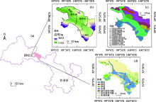
图1
研究区在甘肃省的地理位置(a)、高程(b)、地貌类型(c)和2015年土地利用空间分布(d) 注:底图采用自然资源部标准地图制作,审图号GS(2019)3333号,对底图边界无修改。下同。"

表1
研究数据源信息"
| 类型 | 数据 | 分辨率 | 来源 |
|---|---|---|---|
| 土地利用数据 | 土地利用数据(2000年、2015年) | 30 m | http://www.resdc.cn |
| 自然环境数据 | 年均气温(2015年) | 1 km | |
| 年均降水(2015年) | 1 km | ||
| 高程 | 30 m | ||
| 坡度 | 30 m | ||
| 坡向 | 30 m | ||
| 社会经济数据 | 人口(2015年) | 1 km | |
| GDP(2015年) | 1 km | ||
| 像元与道路的距离数据 | 30 m | ||
| 像元与河流的距离数据 | 30 m | ||
| 像元与居民点的距离数据 | 30 m |

图2
本研究流程"
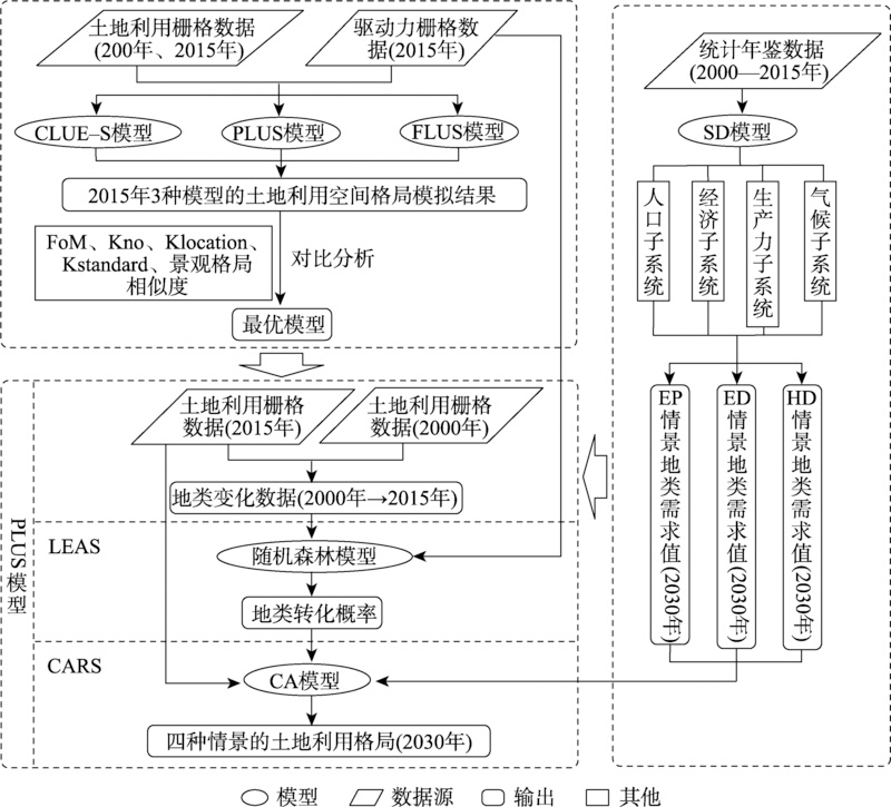
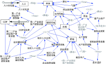
图3
SD模型结构框架"
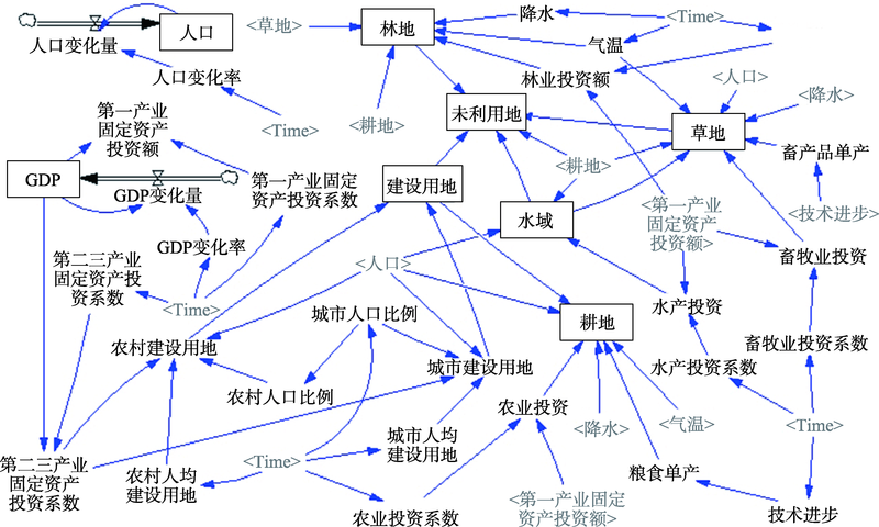
表2
SD模型模拟结果的历史性检验"
| 检验 | 耕地 | 林地 | 草地 | 水域 | 城市建设用地 | 农村建设用地 | 未利用地 |
|---|---|---|---|---|---|---|---|
| 历史值(2015年) | 217147 | 11625 | 149341 | 24752 | 6974 | 15450 | 642389 |
| 模拟值(2015年) | 215784 | 11554 | 149322 | 24695 | 6938 | 14736 | 644650 |
| 相对误差/% | 0.63 | 0.61 | 0.01 | 0.23 | 0.51 | 4.62 | 0.35 |
表3
不同情景的参数设定"
| 变量 | 人口增长率/‰ | GDP增长率/% | 年降雨变化/(mm·a-1) | 年均温变化/(℃·a-1) | 技术系数 | 城镇化率 |
|---|---|---|---|---|---|---|
| HD情景 | 6 | 12 | 0.350 | 0.020 | 400 | 43%线性增至61.8% |
| ED情景 | 10 | 14 | 0.550 | 0.030 | 500 | 43%线性增至65% |
| EP情景 | 4 | 9 | 0.15 | 0.010 | 500 | 43%线性增至60% |
表4
CLUE-S模型的ROC指数"
| 分辨率/m | 耕地 | 林地 | 草地 | 水域 | 城市建设用地 | 农村建设用地 | 未利用地 |
|---|---|---|---|---|---|---|---|
| 30 | 0.731 | 0.566 | 0.57 | 0.509 | 0.569 | 0.684 | 0.758 |
| 50 | 0.935 | 0.696 | 0.737 | 0.722 | 0.915 | 0.834 | 0.893 |
| 100 | 0.935 | 0.698 | 0.729 | 0.728 | 0.867 | 0.832 | 0.892 |
| 200 | 0.935 | 0.68 | 0.738 | 0.72 | 0.928 | 0.833 | 0.892 |
表5
不同模型2015年模拟结果的景观指数"
| 景观指数 | PLUS(50 m) | FLUS(50 m) | CLUE-S(50 m) | 实际(50 m) |
|---|---|---|---|---|
| NP (Number of patches) | 7122.00a | 20303.00c | 11957.00b | 4182.00 |
| LPI (Largest patch index)/% | 43.48c | 52.71a | 53.06b | 50.89 |
| PARA_MN (Mean perimeter-area ratio) | 456.47a | 613.45c | 536.94b | 231.18 |
| PARA_AM (Area-weighted mean perimeter-area ratio) | 36.94b | 63.30c | 36.17a | 33.58 |
| PARA_MD (Median perimeter-area ratio) | 366.67a | 640.00c | 600.00b | 222.22 |
| PARA_RA (Perimeter-area ratio range) | 790.01a | 776.04c | 790.70b | 789.71 |
| PARA_SD (Perimeter-area ratio standard deviation) | 266.51c | 206.07a | 250.83b | 123.03 |
| PARA_CV (Perimeter-area ratio coefficient of variation) | 58.38a | 33.59c | 46.72b | 53.22 |
| ENN_MN (Mean euclidean nearest neighbor distance)/m | 276.76a | 150.13c | 233.80b | 464.08 |
| ENN_AM (Area-weighted mean euclidean nearest neighbor distance)/m | 183.61b | 146.66a | 131.66c | 159.72 |
| ENN_MD (Median euclidean nearest neighbor distance)/m | 141.42a | 111.80c | 141.42a | 223.61 |
| ENN_RA (Euclidean nearest neighbor distance range)/m | 26382.45a | 20753.12c | 24047.88b | 34894.36 |
| ENN_SD (Euclidean nearest neighbor distance standard deviation)/m | 751.54a | 320.79c | 516.44b | 1087.47 |
| ENN_CV (Euclidean nearest neighbor distance coefficient of variation)/m | 271.55c | 213.68b | 220.89a | 234.33 |
| PLADJ (Percentage of like adjacencies)/% | 95.38b | 92.09c | 95.48a | 95.80 |
| Sim | 0.64 | 0.21 | 0.46 |
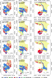
图4
不同模型2015年的模拟结果对比"

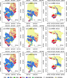
图5
不同情景中的2030年土地利用结构"

表6
不同情景的未来各土地利用类型面积预测结果"
| 类型 | 2015年 | SD模型(2030年) | ||
|---|---|---|---|---|
| ED情景 | EP情景 | HD情景 | ||
| 耕地 | 217147 | 261740 | 203469 | 225155 |
| 林地 | 11625 | 7958 | 14747 | 12165 |
| 草地 | 149341 | 137645 | 152568 | 146553 |
| 水域 | 24752 | 28097 | 25413 | 26704 |
| 城市建设用地 | 6974 | 14253 | 12070 | 13166 |
| 农村建设用地 | 15450 | 14732 | 14845 | 14690 |
| 未利用地 | 642389 | 603253 | 644568 | 629247 |
表7
不同情景的未来各土地利用转移矩阵"
| 情景 | 2015年/2030年 | 耕地 | 林地 | 草地 | 水域 | 城市建设用地 | 农村建设用地 | 未利用地 | 总计 |
|---|---|---|---|---|---|---|---|---|---|
| ED情景 | 耕地 | 215340 | 18 | 272 | 239 | 292 | 0 | 987 | 217147 |
| 林地 | 2803 | 7648 | 421 | 112 | 68 | 0 | 573 | 11625 | |
| 草地 | 6215 | 82 | 134401 | 435 | 283 | 0 | 7924 | 149341 | |
| 水域 | 2825 | 27 | 718 | 17973 | 150 | 0 | 3059 | 24752 | |
| 城市建设用地 | 414 | 7 | 16 | 5 | 6430 | 0 | 103 | 6974 | |
| 农村建设用地 | 708 | 0 | 0 | 1 | 9 | 14732 | 0 | 15450 | |
| 未利用地 | 33435 | 175 | 1818 | 9332 | 7022 | 0 | 590606 | 642389 | |
| 总计 | 261740 | 7958 | 137645 | 28097 | 14253 | 14732 | 603253 | 1067678 | |
| EP情景 | 耕地 | 184921 | 6293 | 11703 | 2506 | 1943 | 26 | 9754 | 217147 |
| 林地 | 1341 | 6718 | 2020 | 150 | 106 | 0 | 1289 | 11625 | |
| 草地 | 4176 | 730 | 121801 | 1467 | 747 | 0 | 20419 | 149341 | |
| 水域 | 1271 | 112 | 1856 | 18428 | 99 | 1 | 2985 | 24752 | |
| 城市建设用地 | 246 | 32 | 94 | 5 | 6354 | 1 | 242 | 6974 | |
| 农村建设用地 | 491 | 9 | 19 | 5 | 50 | 14813 | 64 | 15450 | |
| 未利用地 | 11022 | 854 | 15074 | 2851 | 2770 | 3 | 609815 | 642389 | |
| 总计 | 203469 | 14747 | 152568 | 25413 | 12070 | 14845 | 644568 | 1067678 | |
| HD情景 | 耕地 | 217015 | 2 | 4 | 17 | 25 | 0 | 83 | 217147 |
| 林地 | 139 | 10715 | 11 | 133 | 54 | 0 | 572 | 11625 | |
| 草地 | 2181 | 48 | 146489 | 188 | 94 | 0 | 341 | 149341 | |
| 水域 | 176 | 60 | 17 | 21684 | 118 | 0 | 2697 | 24752 | |
| 城市建设用地 | 22 | 6 | 1 | 1 | 6874 | 0 | 70 | 6974 | |
| 农村建设用地 | 748 | 1 | 0 | 1 | 12 | 14690 | 0 | 15450 | |
| 未利用地 | 4874 | 1334 | 31 | 4679 | 5989 | 0 | 625483 | 642389 | |
| 总计 | 225155 | 12165 | 146553 | 26704 | 13166 | 14690 | 629247 | 1067678 |
| [1] | Turner B L. The sustainability principle in global agendas: Implications for understanding land use/cover change[J]. The Geographical Journal, 1997, 163(2): 114-133. |
| [2] |
Hyandye C. GIS and logit regression model applications in land use/land cover change and distribution in Usangu catchment[J]. American Journal of Remote Sensing, 2015, 3(1): 6-16.
doi: 10.11648/j.ajrs.20150301.12 |
| [3] |
Singh S K, Mustak S, Srivastava P K, et al. Predicting spatial and decadal LULC changes through cellular automata Markov chain models using earth observation datasets and geo-information[J]. Environmental Processes, 2015, 2(1): 61-78.
doi: 10.1007/s40710-015-0062-x |
| [4] |
Verburg P H, Soepboer W, Veldkamp A, et al. Modeling the spatial dynamics of regional land use: the CLUE-S model[J]. Environmental Management, 2002, 30(3): 391-405.
pmid: 12148073 |
| [5] | Filatova T, Verburg P H, Parker D C, et al. Spatial agent-based models for socio-ecological systems: Challenges and prospects[J]. Environmental Modelling & Software, 2013, 45: 1-7. |
| [6] |
严冬, 李爱农, 南希, 等. 基于Dyna-CLUE改进模型和SD模型耦合的山区城镇用地情景模拟研究——以岷江上游地区为例[J]. 地球信息科学学报, 2016, 18(4): 514-525.
doi: 10.3724/SP.J.1047.2016.00514 |
|
[Yan Dong, Li Ainong, Nan Xi, et al. The study of urban land scenario simulation in mountain area based on modified Dyna-CLUE model and SD: A case study of the upper reaches of Minjiang River[J]. Journal of Geo-Information Science, 2016, 18(4): 514-525.]
doi: 10.3724/SP.J.1047.2016.00514 |
|
| [7] |
田贺, 梁迅, 黎夏, 等. 基于SD模型的中国2010-2050年土地利用变化情景模拟[J]. 热带地理, 2017, 37(4): 547-561.
doi: 10.13284/j.cnki.rddl.002939 |
|
[Tian He, Liang Xun, Li Xia, et al. Simulating multiple land use scenarios in China during 2010-2050 based on system dynamic model[J]. Tropical Geography, 2017, 37(4): 547-561.]
doi: 10.13284/j.cnki.rddl.002939 |
|
| [8] | 何春阳, 史培军, 陈晋, 等. 基于系统动力学模型和元胞自动机模型的土地利用情景模型研究[J]. 中国科学(D辑: 地球科学), 2005, 35(5): 464-473. |
| [He Chunyang, Shi Peijun, Chen Jin, et al. Research on land use scenario model based on system dynamics model and cellular automata model[J]. Science in China Ser. D Earth Sciences, 2005, 35(5): 464-473.] | |
| [9] | 黎夏, 刘小平. 基于案例推理的元胞自动机及大区域城市演变模拟[J]. 地理学报, 2007, 62(10): 1097-1109. |
| [Li Xia, Liu Xiaoping. Case-based cellular automation for simulating urban development in a large complex region[J]. Acta Geographic Sinica, 2007, 62(10): 1097-1109.] | |
| [10] |
Luo G, Yin C, Chen X, et al. Combining system dynamic model and CLUE-S model to improve land use scenario analyses at regional scale: A case study of Sangong watershed[J]. Ecological Complexity, 2010, 7(2): 198-207.
doi: 10.1016/j.ecocom.2010.02.001 |
| [11] |
Peter H V, Koen P O. Combining top-down and bottom-up dynamics in land use modeling: Exploring the future of abandoned farmlands in Europe with the Dyna-CLUE model[J]. Landscape Ecology, 2009, 24(9): 1167-1181.
doi: 10.1007/s10980-009-9355-7 |
| [12] | Olmedo M T C, Jr R G P, Paegelow M, et al. Comparison of simulation models in terms of quantity and allocation of land change[J]. Environmental Modelling & Software, 2015, 69: 214-221. |
| [13] |
戴尔阜, 马良. 土地变化模型方法综述[J]. 地理科学进展, 2018, 37(1): 152-162.
doi: 10.18306/dlkxjz.2018.01.016 |
|
[Dai Erfu, Ma Liang. Review on land change modeling approaches[J]. Progress in Geography, 2018, 37(1): 152-162.]
doi: 10.18306/dlkxjz.2018.01.016 |
|
| [14] | 余强毅, 吴文斌, 唐华俊, 等. 复杂系统理论与Agent模型在土地变化科学中的研究进展[J]. 地理学报, 2011, 66(11): 1518-1530. |
| [Yu Qiangyi, Wu Wenbin, Tang Huajun, et al. Complex system theory and agent-based modeling: Progresses in land change science[J]. Acta Geographic Sinica, 2011, 66(11): 1518-1530.] | |
| [15] |
He X D, Mai X M, Shen G Q. Delineation of urban growth boundaries with SD and CLUE-S models under multi-scenarios in Chengdu Metropolitan Area[J]. Sustainability, 2019, 11(21): 5919.
doi: 10.3390/su11215919 |
| [16] |
Liang Y, Liu L, Huang J. Integrating the SD-CLUE-S and InVEST models into assessment of oasis carbon storage in northwestern China[J]. Plos One, 2017, 12(2): e0172494..
doi: 10.1371/journal.pone.0172494 |
| [17] |
Ding Q, Chen Y, Bu L, et al. Multi-scenario analysis of habitat quality in the Yellow River Delta by coupling FLUS with InVEST model[J]. International Journal of Environmental Research and Public Health, 2021, 18(5): 2389.
doi: 10.3390/ijerph18052389 |
| [18] | Liang X, Guan Q, Clarke K C, et al. Understanding the drivers of sustainable land expansion using a patch-generating land use simulation (PLUS) model: A case study in Wuhan, China[J]. Computers, Environment and Urban Systems, 2021, 85: 1-14. |
| [19] |
Verburg P H, Veldkamp T, Bouma J. Land use change under conditions of high population pressure: the case of Java[J]. Global Environmental Change, 1999, 9(4): 303-312.
doi: 10.1016/S0959-3780(99)00175-2 |
| [20] |
Liu X, Liang X, Li X, et al. A future land use simulation model (FLUS) for simulating multiple land use scenarios by coupling human and natural effects[J]. Landscape Urban Plan, 2017, 168: 94-116.
doi: 10.1016/j.landurbplan.2017.09.019 |
| [21] | Peng K, Jiang W, Deng Y, et al. Simulating wetland changes under different scenarios based on integrating the random forest and CLUE-S models: A case study of Wuhan Urban Agglomeration[J]. Ecological Indicators, 2020, 117: 1-13. |
| [22] |
Moulds S, Buytaert W, Mijic A. An open and extensible framework for spatially explicit land use change modelling: The lulcc R package[J]. Geoscientific Model Development, 2015, 8(10): 3215-3229.
doi: 10.5194/gmd-8-3215-2015 |
| [23] | 林丽, 樊辉, 金缘. 山区县域土地利用/覆被变化多尺度多模型模拟对比——以云南省勐腊县为例[J]. 山地学报, 2020, 38(4): 630-642. |
| [Lin Li, Fan Hui, Jin Yuan. Multi-scale and multi-model simulation of land use/land cover change in the mountainous county: A case study of Mengla County in Yunnan Province, China[J]. Mountain Research, 2020, 38(4): 630-642.] | |
| [24] | 张勃, 毛彦成, 柳景峰. 黑河中游土地利用/覆盖变化驱动力的定量分析[J]. 干旱区地理, 2006, 29(5): 726-730. |
| [Zhang Bo, Mao Yancheng, Liu Jingfeng. Analysis driving forces of LUCC in Heihe middle reaches[J]. Arid Land Geography, 2006, 29(5): 726-730.] | |
| [25] |
Pontius R G, Schneider L C. Land-cover change model validation by an ROC method for the Ipswich watershed, Massachusetts, USA[J]. Agriculture, Ecosystems and Environment, 2001, 85(1-3): 239-248.
doi: 10.1016/S0167-8809(01)00187-6 |
| [26] |
Pontius R G, Boersma W, Castella J, et al. Comparing the input, output, and validation maps for several models of land change[J]. The Annals of Regional Science, 2007, 42(1): 11-37.
doi: 10.1007/s00168-007-0138-2 |
| [27] |
Pontius R G, Millones M. Death to Kappa: Birth of quantity disagreement and allocation disagreement for accuracy assessment[J]. International Journal of Remote Sensing, 2011, 32(15): 4407-4429.
doi: 10.1080/01431161.2011.552923 |
| [28] |
Chen Y, Li X, Liu X, et al. Capturing the varying effects of driving forces over time for the simulation of urban growth by using survival analysis and cellular automata[J]. Landscape Urban Plan, 2016, 152: 59-71.
doi: 10.1016/j.landurbplan.2016.03.011 |
| [29] | Pontius R G. Quantification error versus location error in comparison of categorical maps[J]. Photogrammetric Engineering and Remote Sensing, 2000, 66(8): 1011-1016. |
| [30] | 李秀霞, 徐龙, 江恩赐. 基于系统动力学的土地利用结构多目标优化[J]. 农业工程学报, 2013, 29(16): 247-254. |
| [Li Xiuxia, Xu Long, Jiang Enci. Multi-objective optimization of land use structure in western Jilin Province based on system dynamics[J]. Transactions of the Chinese Society of Agricultural Engineering, 2013, 29(16): 247-254.] | |
| [31] | 国家统计局. 中国统计年鉴[M]. 北京: 中国统计出版社, 2000-2015. |
| [National Bureau of Statistics. China Statistical Yearbook[M]. Beijing: China Statistics Press, 2000-2015.] | |
| [32] | 张掖年鉴编纂委员会. 张掖年鉴[M]. 甘肃: 敦煌文艺出版社, 2000-2015. |
| [Zhangye Yearbook Editorial Board. Zhangye yearbook[M]. Gansu: Dunhuang Literature and Art Publishing House, 2000-2015.] | |
| [33] | 甘肃年鉴编纂委员会. 甘肃发展年鉴[M]. 北京: 中国统计出版社, 2000-2015. |
| [Gansu Development Yearbook Editorial Board. Gansu Development Yearbook[M]. Beijing: China Statistics Press, 2000-2015.] | |
| [34] | 国家统计局城市社会经济调查司. 中国城市发展年鉴[M]. 北京: 中国统计出版社, 2000-2015. |
| [Department of Urban Society and Economic Statistics National Bureau of Statistics of China. China City Statistical Yearbook[M]. Beijing: China Statistics Press, 2000-2015.] | |
| [35] | IPCC. Climate Change 2013:The Physical Science Basis. Contribution of Working Group I to the Fifth Assessment Report of the Intergovernmental Panel on Climate Change[R]. Cambridge and New York: Cambridge University Press, 2013: 159-254. |
| [36] | 梁友嘉, 徐中民, 钟方雷. 基于SD和CLUE-S模型的张掖市甘州区土地利用情景分析[J]. 地理研究, 2011, 30(3): 564-576. |
| [Liang Youjia, Xu Zhongmin, Zhong Fanglei. Land use scenario analyses by based on system dynamic model and CLUE-S model at regional scale: A case study of Ganzhou district of Zhangye City[J]. Geographic Research, 2011, 30(3): 564-576.] | |
| [37] | 刘玉钢, 王立宇. 济南市土地利用变化模拟预测研究[J]. 国土与自然资源研究, 2021(1): 47-50. |
| [Liu Yugang, Wang Liyu. Research on simulation and prediction of land use change in Jinan City[J]. Territory & Natural Resources Study, 2021(1): 47-50.] | |
| [38] | 张永民, 周成虎, 郑纯辉, 等. 沽源县土地利用格局的多尺度模拟与分析[J]. 资源科学, 2006, 28(2): 88-96. |
| [Zhang Yongmin, Zhou Chenghu, Zheng Chunhui, et al. Spatial land use patterns in Guyuan County: Simulation and analysis at multi-scale levels[J]. Resources Science, 2006, 28(2): 88-96.] | |
| [39] |
Saysel A K, Barlas Y, Yenigün O. Environmental sustainability in an agricultural development project: A system dynamics approach[J]. Journal of Environmental Management, 2002, 64(3): 247-260.
pmid: 12040958 |
| [40] | 苏迎庆, 刘庚, 赵景波, 等. 基于FLUS模型的汾河流域生态空间多情景模拟预测[J]. 干旱区研究, 2021, 38(4): 1152-1161. |
| [Su Yingqing, Liu Geng, Zhao Jingbo, et al. Multi-scenario simulation prediction of ecological space in the Fenhe River Basin using the FLUS model[J]. Arid Zone Research, 2021, 38(4): 1152-1161.] | |
| [41] | 金梦婷, 徐丽萍, 徐权. 基于FLUS-Markov模型的多情景景观生态风险评价与预测——以南疆克州为例[J]. 干旱区研究, 2021, 38(6): 1793-1804. |
| [Jin Mengting, Xu Liping, Xu Quan. FLUS-Markov model-based multiscenario evaluation and prediction of the landscape ecological risk in Kezhou, South Xinjiang[J]. Arid Zone Research, 2021, 38(6): 1793-1804.] | |
| [42] |
Lu Xing, Xue M G, Hu M S. Dynamic simulation and assessment of the coupling coordination degree of the economy-resource-environment system: Case of Wuhan City in China[J]. Journal of Environmental Management, 2019, 230: 474-487.
doi: S0301-4797(18)31075-2 pmid: 30340121 |
| [43] |
Wu M, Ren X, Che Y, et al. A coupled SD and CLUE-S model for exploring the impact of land use change on ecosystem service value: A case study in Baoshan District, Shanghai, China[J]. Environmental Management, 2015, 56(2): 402-419.
doi: 10.1007/s00267-015-0512-2 |
| [44] | 傅颖秀, 张金龙, 陈英, 等. 黑河中游典型绿洲土地利用/覆盖变化及生态环境效应——以甘州、临泽、高台绿洲为例[J]. 干旱区资源与环境, 2014, 28(10): 104-109. |
| [Fu Yingxiu, Zhang Jinlong, Chen Ying, et al. LUCC and its environmental effects on the typical oases in the middle reaches of Heihe River Basin: Case of Linze and Gaotai Oases in Ganzhou[J]. Journal of Arid Land Resources and Environment, 2014, 28(10): 104-109.] | |
| [45] | 田文婷, 颉耀文, 陈云海. 近50 a高台县绿洲时空变化研究[J]. 干旱区研究, 2013, 30(6): 1122-1128. |
| [Tian Wenting, Xie Yaowen, Chen Yunhai. Spatiotemporal change of the oasis in Gaotai County in recent 50 years[J]. Arid Zone Research, 2013, 30(6): 1122-1128.] | |
| [46] |
Wang J, Chen Y Q, Shao X M, et al. Land-use changes and policy dimension driving forces in China: Present, trend and future[J]. Land Use Policy, 2012, 29(4): 737-749.
doi: 10.1016/j.landusepol.2011.11.010 |
| [47] |
曹祺文, 顾朝林, 管卫华. 基于土地利用的中国城镇化SD模型与模拟[J]. 自然资源学报, 2021, 36(4): 1062-1084.
doi: 10.31497/zrzyxb.20210419 |
|
[Cao Qiwen, Gu Chaolin, Guan Weihua. China’s urbanization SD modelling and simulation based on land use[J]. Journal of Natural Resources, 2021, 36(4): 1062-1084.]
doi: 10.31497/zrzyxb.20210419 |
| [1] | 苏迎庆,张恩月,刘源,刘庚,林菲. 汾河流域土地利用变化及生态环境效应[J]. 干旱区研究, 2022, 39(3): 968-977. |
| [2] | 刘婉如,陈春波,罗格平,何惠丽. 巴尔喀什湖流域土地利用/覆被变化过程与趋势[J]. 干旱区研究, 2021, 38(5): 1452-1463. |
| [3] | 郭靖,王光焰,徐生武,张广朋,苑塏烨,凌红波,夏依旦·吾买尔江. 水资源管理增强下的塔里木河上中游碳储量动态评估[J]. 干旱区研究, 2021, 38(3): 589-599. |
| [4] | 田义超, 梁铭忠. 黄土台塬区土地利用/覆被变化定量研究——以陕西省咸阳台塬区为例[J]. 干旱区研究, 2013, 30(3): 563-569. |
|
||