干旱区研究 ›› 2024, Vol. 41 ›› Issue (2): 200-210.doi: 10.13866/j.azr.2024.02.03
王启花1( ), 林春英1(), 刘潇2, 张莉燕1, 赵占秀3, 张博越1, 龚静1
收稿日期:2023-03-24
修回日期:2023-11-07
出版日期:2024-02-15
发布日期:2024-03-11
通讯作者:
林春英. E-mail: 作者简介:王启花(1991-), 女, 工程师, 主要从事云降水物理与人工影响天气研究. E-mail: wangqhnuist@sina.com
基金资助:
WANG Qihua1(), LIN Chunying1(), LIU Xiao2, ZHANG Liyan1, ZHAO Zhanxiu3, ZHANG Boyue1, GONG Jing1
Received:2023-03-24
Revised:2023-11-07
Online:2024-02-15
Published:2024-03-11
摘要:
青海东北部是青海省主要的农作物生产区、也是冰雹高发区和灾害影响的高风险区,冰雹预报预警和人工防雹作业是降低冰雹灾害的重要手段,掌握冰雹发生时各监测资料的变化特征是提高冰雹预报能力、尽早开展人工防雹作业的前提。2021年6月29日青海东北部出现了一次大范围的冰雹天气过程,利用多普勒天气雷达、雨滴谱资料,结合高空和地面常规气象资料,对此次冰雹天气过程进行了分析。结果表明:青海东北部地区高空有冷平流输送,地面增温明显,导致层结不稳定,是产生此次冰雹的天气背景。平安地区降雹阶段平均雨滴谱和速度谱均呈多峰分布,人工观测的平安冰雹最大直径和雨滴谱仪观测的相差不大,说明雨滴谱仪能很好的观测到冰雹粒子,并且能确定最大冰雹出现的时间。雹云发展大致经历了发生、跃增、降雹和消亡等阶段,降雹前低层雷达反射率因子出现明显的“V”字型入流缺口;雹云成熟阶段具有明显的有界弱回波区结构,中低层有明显的偏南气流入流,且此时径向速度图上雹云有明显的“0线”,“0线”垂直向上,穿过悬垂回波和有界弱回波区域上部,指向冰雹云顶。此次冰雹个例的分析,对青海东北部冰雹预报具有重要的指导意义,冰雹发生前各要素变化特征是后期科学指导防雹作业点适时、适量开展人工防雹作业的重要判据。
王启花, 林春英, 刘潇, 张莉燕, 赵占秀, 张博越, 龚静. 青海东北部一次典型冰雹过程的观测分析[J]. 干旱区研究, 2024, 41(2): 200-210.
WANG Qihua, LIN Chunying, LIU Xiao, ZHANG Liyan, ZHAO Zhanxiu, ZHANG Boyue, GONG Jing. Observational analysis of a hailstorm event in Northeast Qinghai[J]. Arid Zone Research, 2024, 41(2): 200-210.
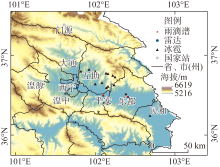
图1
探测仪器分布 注:底图采用自然资源部标准地图制作,审图号为GS(2017)3320号,对底图边界无修改。下同。"

表1
2021年6月29日降雹实况"
| 互助 | 互助 | 平安 | 乐都 | 民和 | |
|---|---|---|---|---|---|
| 降雹时间 | 17:16—17:24 | 17:47—17:49 | 18:03—18:11 | 18:20—18:30 | 18:49—18:50 |
| 最大冰雹直径/mm | 7 | 4 | 16 | 20 | - |
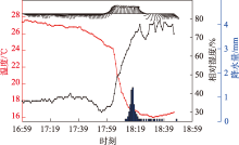
图2
平安站地面1 min气象要素时间分布"
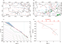
图3
2021年6月29日08:00 500 hPa高空图(a)、14:00地面图(b)、08:00西宁站T-lnp(c)、08:00西宁站温度-相对湿度随高度变化(d)"


图4
平安站降雹天气过程中雨滴谱(a)、速度谱(b)随时间的演变"

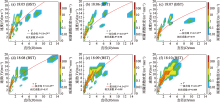
图5
冰雹过程中粒子速度拟合"

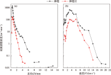
图6
平安站降雹过程中和降雹后平均雨滴谱(a)、速度谱(b)"


图7
雹云发展阶段最大回波强度、垂直累积液态含水量和回波顶高演变"


图8
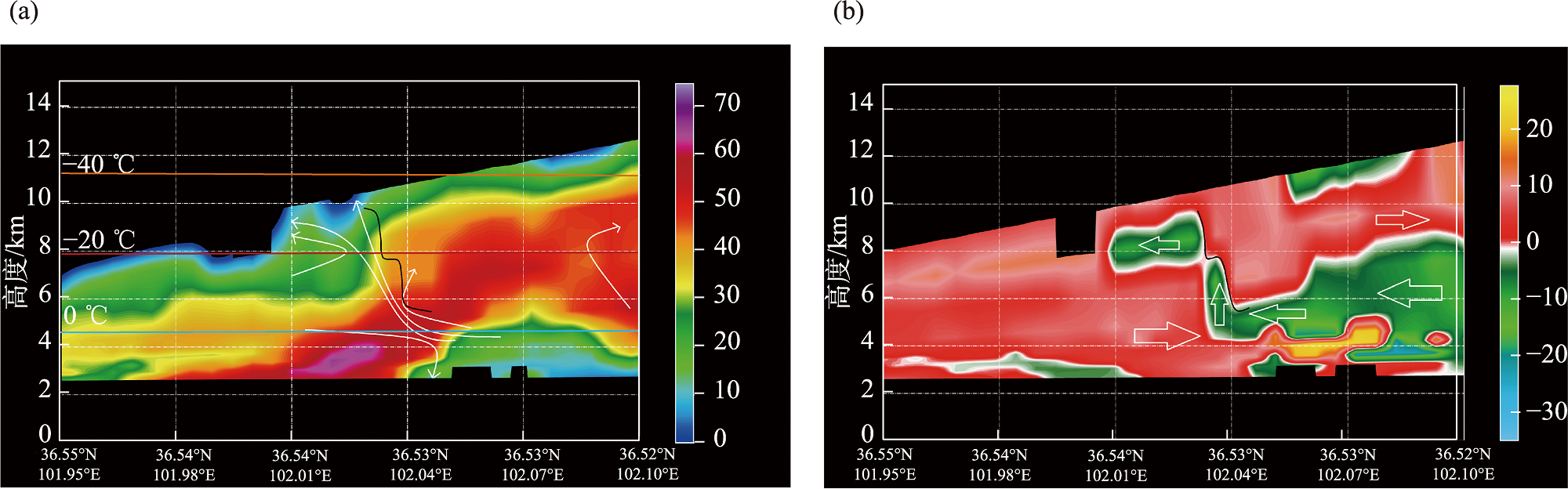
2021年6月29日2.4°仰角基本反射率因子 注:(a)、(b)中黑线区域为“V”型缺口;(c)中黑虚线为图10中的剖面位置。"

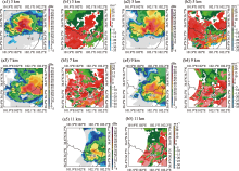
图9
2021年6月29日17:54不同高度反射率因子(a1~a5)和径向速度(b1~b5)显示的雹云结构 注:(a1)~(a5)为3~11 km(间隔2 km)的反射率因子;(b1)~(b5)为与(a1)~(a5)同高度的径向速度CAPPI。"
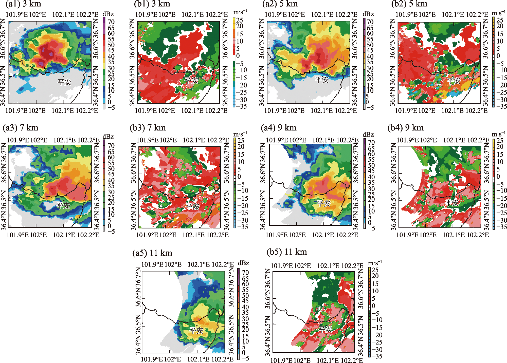
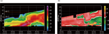
图10
2021年6月29日17:54沿图8c黑虚线的反射率因子(a, 黑线为“0线”)和径向速度(b, 箭头指向气流运动方向)剖面"
| [1] | 赵先丽, 李丽光, 贾庆宇, 等. 1988—2007年辽宁主要农业气象灾害分析[J]. 气象与环境学报, 2009, 25(2): 33-37. |
| [Zhao Xianli, Li Liguang, Jia Qingyu, et al. Analysis of main agrometeorological disasters from 1988 to 2007 in Liaoning Province[J]. Journal of Meteorology and Environment, 2009, 25(2): 33-37.] | |
| [2] | 龚静, 王青川. 青海省东部农业区高炮人工防雹效果评估[J]. 青海科技, 2008, 14(6): 36-39. |
| [Gong Jing, Wang Qingchuan. Evaluation of hail suppression effect of antiaircraft artillery in eastern agricultural area of Qinghai Province[J]. Qinghai Science and Technology, 2008, 14(6): 36-39.] | |
| [3] |
孙鸿烈, 郑度, 姚檀栋, 等. 青藏高原国家生态安全屏障保护与建设[J]. 地理学报, 2012, 67(1): 3-12.
doi: 10.11821/xb201201001 |
|
[Sun Honglie, Zheng Du, Yao Tandong, et al. Protection and construction of the national ecological security shelter zone on Tibetan Plateau[J]. Acta Geographica Sinica, 2012, 67(1): 3-12.]
doi: 10.11821/xb201201001 |
|
| [4] |
周嵬, 张强, 康凤琴. 我国西北地区降雹气候特征及若干研究进展[J]. 地球科学进展, 2005, 20(9):1029 -1036.
doi: 10.11867/j.issn.1001-8166.2005.09.1029 |
| [Zhou Wei, Zhang Qiang, Kang Fengqin. Recent advancements of hail research in Northwest China[J]. Advances in Earth Science, 2005, 20(9): 1029 -1036.] | |
| [5] |
Johns R H, Doswell III C A. Severe local storms forecasting[J]. Weather Forecast, 1992, 7: 588-612.
doi: 10.1175/1520-0434(1992)007<0588:SLSF>2.0.CO;2 |
| [6] | 刘晓璐, 刘建西, 张世林, 等. 基于探空资料因子组合分析方法的冰雹预报[J]. 应用气象学报, 2014, 25(2): 168-175. |
| [Liu Xiaolu, Liu Jianxi, Zhang Shilin, et al. Hail forecast based on factor combination analysis method and sounding data[J]. Journal of Applied Meteorological Science, 2014, 25(2): 168-175.] | |
| [7] | 王艳兰, 王娟, 伍静, 等. 桂林市2019年“3.21”极端大风与“4.24”致灾冰雹过程特征对比分析[J]. 热带气象学报, 2021, 37(2): 175-785. |
| [Wang Yanlan, Wang Juan, Wu Jing, et al. Comparative analysis of characteristics of “3.21” extreme gale and “4.24” hailstrom in Guilin in 2019[J]. Journal of Tropical Meteorology, 2021, 37(2): 175-185.] | |
| [8] | 张腾飞, 段旭, 鲁亚斌, 等. 云南一次强对流冰雹过程的环流及雷达回波特征分析[J]. 高原气象, 2006, 25(3): 531-538. |
| [Zhang Tengfei, Duan Xu, Lu Yabin, et al. Circulation background for a severe convective hailstorm weather process in Yunnan and its dopplar radar echo features[J]. Plateau Meteorology, 2006, 25(3): 531-538.] | |
| [9] | 王培涛, 王凤娇, 张婷婷. 山东滨州市冰雹天气分型和预报方法研究[J]. 沙漠与绿洲气象, 2019, 13(3): 33-40. |
| [Wang Peitao, Wang Fengjiao, Zhang Tingting. Study on classification of synoptic systems and forecasting method of hail in Binzhou Shandong Province[J]. Desert and Oasis Meteorology, 2019, 13(3): 33-40.] | |
| [10] | 沈树勤, 顾锋峰. 降雹前地面要素场的合成分析和冰雹的临近预报[J]. 气象, 1988, 14(6): 5-8. |
| [Shen Shuqin, Gu Fengfeng. A composite analysis of surface factors in advanced of hail shooting and the nowcasting of hail[J]. Meteorological Monthly, 1988, 14(6): 5-8.] | |
| [11] |
段艺萍, 刘寿东, 刘黎平, 等. 新一代天气雷达三维组网产品在人工防雹的应用[J]. 高原气象, 2014, 33(5): 1426-1439.
doi: 10.7522/j.issn.1000-0534.2013.00139 |
|
[Duan Yiping, Liu Shoudong, Liu Liping, et al. Application of cinrad mosaic products on artificial hail suppression[J]. Plateau Meteorology, 2014, 33(5): 1426-1439.]
doi: 10.7522/j.issn.1000-0534.2013.00139 |
|
| [12] | 陶岚, 管理, 孙敏, 等. 双线偏振多普勒雷达对一次降雹超级单体发展减弱阶段的演变分析[J]. 气象科学, 2019, 39(5): 685-697. |
| [Tao Lan, Guan Li, Sun Min, et al. Evolution analysis of a hail-producing supercell using dual polarization doppler radar[J]. Journal of the Meteorological Sciences, 2019, 39(5): 685-697.] | |
| [13] | 吴剑坤, 俞小鼎. 强冰雹天气的多普勒天气雷达探测与预警技术综述[J]. 干旱气象, 2009, 27(3): 197-206. |
| [Wu Jiankun, Yu Xiaoding. Review of detection and warning methods for sever hail events by doppler weather radars[J]. Journal of Arid Meteorology, 2009, 27(3): 197-206.] | |
| [14] | 曹舒娅, 孙伟, 韦芬芬, 等. 双偏振雷达在江苏“7.6”降雹过程中的应用分析[J]. 大气科学学报, 2021, 44(4): 549-557. |
| [Cao Shuya, Sun Wei, Wei Fenfen, et al. Study of “7.6” hail event in Jiangsu based on dual-polarization weather radar observations[J]. Transactions of Atmospheric Sciences, 2021, 44(4): 549-557.] | |
| [15] | 孙伟, 曹舒娅, 沈建. 基于多源探测资料的“4.12”非典型冰雹特征分析[J]. 热带气象学报, 2021, 37(2): 218-232. |
| [Sun Wei, Cao Shuya, Shen Jian. Characteristic analysis of “4.12” atypical hail based on multi-source data[J]. Journal of Tropical Meteorology, 2021, 37(2): 218-232.] | |
| [16] | 张芳, 虎文珺, 晁剑. 青海省东部农业区冰雹天气特征分析及预警指标研究[J]. 沙漠与绿洲气象, 2020, 14(1): 63-71. |
| [Zhang Fang, Hu Wenjun, Chao Jian. Analysis of hail weather characteristics and early warning indexes in agricultural regions in eastern Qinghai Province[J]. Desert and Oasis Meteorology, 2020, 14(1): 63-71.] | |
| [17] | 朱平, 肖建设, 伏洋. 青藏高原东北部冰雹和雷雨预警的风暴单体识别特征对比分析[J]. 干旱区研究, 2012, 29(6): 941-948. |
| [Zhu Ping, Xiao Jianshe, Fu Yang. Analysis on identification characters of storm cells for early warning of hail and thunder storms in the Northeast Qinghai Tibetan Plateau[J]. Arid Zone Research, 2012, 29(6): 941-948.] | |
| [18] | 赵瑞金, 杨德保, 董保华, 等. 石家庄地区冰雹天气环境条件的多普勒天气雷达资料分析[J]. 气象科学, 2008, 28(6): 689-696. |
| [Zhao Ruijin, Yang Debao, Dong Baohua, et al. The analysis of environment condition of hail in Shijiazhuang using doppler weather radar products[J]. Journal of the Meteorological Sciences, 2008, 28(6): 689-696.] | |
| [19] | 李嘉, 马中元, 郑媛媛, 等. 一次强飑线过程多尺度回波系统特征分析[J]. 气象科学, 2022, 42(5): 622-630. |
| [Li Jia, Ma Zhongyuan, Zheng Yuanyuan, et al. Evolution of multi-scale echo system during a strong squall line process[J]. Journal of the Meteorological Sciences, 2022, 42(5): 622-630.] | |
| [20] | 范皓, 杨永胜, 段英, 等. 太行山东麓一次强对流冰雹云结构的观测分析[J]. 气象学报, 2019, 77(5): 823-834. |
| [Fan Hao, Yang Yongsheng, Duan Ying, et al. An observational analysis of the cloud structure of a severe convective hailstorm over the eastern foothill of Taihang Mountain[J]. Acta Meteorological Sinica, 2019, 77(5): 823-834.] | |
| [21] | 龚佃利, 王洪, 许焕斌, 等. 2019年8月16日山东诸城一次罕见强雹暴结构和大雹形成的观测分析[J]. 气象学报, 2021, 79(4): 674-688. |
| [Gong Dianli, Wang Hong, Xu Huanbin, et al. Observational analysis of a rare and severe hailstorm cloud structure and large hailstones formation on 16 August 2019 in Zhucheng, Shandong Province[J]. Acta Meteorological Sinica, 2021, 79(4): 674-688.] | |
| [22] | 蔡淼, 周毓荃, 蒋元华, 等. 一次超级单体雹暴观测分析和成雹区识别研究[J]. 大气科学, 2014, 38(5): 845-860. |
| [Cai Miao, Zhou Yuquan, Jiang Yuanhua, et al. Observations, analysis, and hail-forming area identification of a supercell hailstorm[J]. Chinese Journal of Atmospheric Sciences, 2014, 38(5): 845-860.] | |
| [23] | 李红斌, 孙鸿雁, 程相坤, 等. 大连地区冰雹气候特怔及防雹天气预誓慨念模型[J]. 高原气象, 2010, 29(6): 1565-1570. |
| [Li Hongbin, Sun Hongyan, Cheng Xiangkun, et al. Climate characteristic of hail and conceptual model of hail suppression in Dalian region[J]. Plateau Meteorology, 2010, 29(6): 1565-1570.] | |
| [24] | 张之贤, 张强, 陶际春. 边界层对青藏高原东北边坡地区一次冰雹天气影响的数值诊断分析[J]. 干旱区研究, 2015, 32(2): 321-328. |
| [Zhang Zhixian, Zhang Qiang, Tao Jichun. Diagnostic analysis of the effect of planet boundary layer on a hail event in the northeastern edge of Qinghai-Tibetan Plateau[J]. Arid Zone Research, 2015, 32(2): 321-328.] | |
| [25] | 洪延超, 肖辉, 李宏宇, 等. 冰雹云中微物理过程研究[J]. 大气科学, 2002, 26(3): 421-432. |
| [Hong Yanchao, Xiao Hui, Li Hongyu, et al. Studies on microphysical processes in hail cloud[J]. Chinese Journal of Atmospheric Sciences, 2002, 26(3): 421-432.] | |
| [26] | 朱好奇, 平凡, 谭桂容, 等. 一次北京冰雹形成的数值模拟及微物理机制研究[J]. 大气科学. doi: 10.3878/j.issn.1006-9895.2303.22213. |
| [Zhu Haoqi, Ping Fan, Tan Guirong, et al. Numerical simulation and study on the microphysical mechanism of hail formation in Beijing[J]. Chinese Journal of Atmospheric Sciences. doi: 10.3878/j.issn.1006-9895.2303.22213.] | |
| [27] | 刘春文, 郭学良, 段玮, 等. 云南一次典型降雹过程的冰雹微物理形成机理数值模拟研究[J]. 大气科学, 2021, 45(5): 965-980. |
| [Liu Chunwen, Guo Xueliang, Duan Wei, et al. Numerical simulation on the microphysical formation mechanism of a typical hailstorm process in Yunnan, southwestern China[J]. Chinese Journal of Atmospheric Sciences, 2021, 45(5): 965-980.] | |
| [28] | 张小娟, 陶玥, 刘国强, 等. 一次冰雹天气过程的云系发展演变及云物理特征研究[J]. 气象, 2019, 45(3): 415-425. |
| [Zhang Xiaojuan, Tao Yue, Liu Guoqiang, et al. Study on the evolution of hailstorm and its cloud physical characteristics[J]. Meteorological Monthly, 2019, 45(3): 415-425.] | |
| [29] | 康凤琴, 张强, 马胜萍, 等. 青藏高原东北边缘冰雹形成机理[J]. 高原气象, 2004, 23(6): 749-757. |
| [Kang Fengqin, Zhang Qiang, Ma Shengping, et al. Mechanism of hail formation on the Northeast border of Qinghai-Xizang Plateau and its Neighbourhood[J]. Plateau Meteorology, 2004, 23(6): 749-757.] | |
| [30] | Kang Fengqin, Zhang Qiang, Lu Shihua. Validation and development of a new hailstone formation theory-numerical simulations of a strong hailstorm occurring over the Qinghai-Tibetan Plateau[J]. Journal of Geophysical Research: Atmospheres, 2007, 112: 1-13. |
| [31] | 黄治勇, 徐桂荣, 王晓芳, 等. 基于地基微波辐射计资料对咸宁两次冰雹天气的观测分析[J]. 气象, 2014, 40(2): 216-222. |
| [Huang Zhiyong, Xu Guirong, Wang Xiaofang, et al. Analysis on two hailstorm events in Xianning based on observations of ground based microwave radiometer[J]. Meteorological Monthly, 2014, 40(2): 216-222.] | |
| [32] |
黄治勇, 周志敏, 徐桂荣, 等. 风廓线雷达和地基微波辐射计在冰雹天气监测中的应用[J]. 高原气象, 2015, 34(1): 269-278.
doi: 10.7522/j.issn.1000-0534.2013.00130 |
|
[Huang Zhiyong, Zhou Zhimin, Xu Guirong, et al. Monitoring application of hailstorm event with the observation of wind profile radar and ground-based microwave radiometer[J]. Plateau Meteorology, 2015, 34(1): 269-278.]
doi: 10.7522/j.issn.1000-0534.2013.00130 |
|
| [33] | 陶涛, 张立新, 桑建人, 等. 六盘山区一次非典型冰雹天气过程微物理量特征的分析[J]. 干旱区地理, 2020, 43(2): 299-307. |
| [Tao Tao, Zhang Lixin, Sang Jianren, et al. A case analysis of microphysical characteristics of atypical hail formation over Liupan Mountain, China[J]. Arid Land Geography, 2020, 43(2): 299-307.] | |
| [34] | 柯莉萍, 谷晓平, 张艳, 等. 贵州乌蒙山区雨滴谱特征及降水估测研究[J]. 云南大学学报: 自然科学版, 2021, 43(6): 1166-1175. |
| [Ke Liping, Gu Xiaoping, Zhang Yan, et al. Characteristics of raindrop spectrum and precipitation estimation in Wumeng Mountain area, Guizhou Province[J]. Journal of Yunnan University: Natural Sciences Edition, 2021, 43(6): 1166-1175.] | |
| [35] | 濮江平, 赵国强, 蔡定军, 等. Parsivel(R)激光降水粒子谱仪及其在气象领域的应用[J]. 气象与环境科学, 2007, 30(2): 3-8. |
| [Pu Jiangping, Zhao Guoqiang, Cai Dingjun, et al. Parsivel recipitation particle spectrometer and application meteorological realm[J]. Meteorological and Environmental Sciences, 2007, 30(2): 3-8.] | |
| [36] |
岳治国, 梁谷. 陕西渭北一次降雹过程的粒子谱特征分析[J]. 高原气象, 2018, 37(6): 1716-1724.
doi: 10.7522/j.issn.1000-0534.2018.00023 |
|
[Yue Zhiguo, Liang Gu. Characteristics of precipitation particles in a hailstorm process in Weibei area of Shaanxi Province[J]. Plateau Meteorology, 2018, 37(6): 1716-1724.]
doi: 10.7522/j.issn.1000-0534.2018.00023 |
|
| [37] | 徐家骝. 冰雹微物理与成雹机制[M]. 北京: 农业出版社, 1979: 110. |
| [Xu Jialiu. The Microphysics of Hail and the Mecha-Nism of Hail Formation[M]. Beijing: China Agriculture Press, 1979: 110.] | |
| [38] | 李聪, 姜有山, 姜迪, 等. 一次冰雹天气过程的多源资料观测分析[J]. 气象, 2017, 43(9): 1084-1094. |
| [Li Cong, Jiang Youshan, Jiang Di, et al. Observation and analysis of a hailstorm event based on multi-source data[J]. Meteorological Monthly, 2017, 43(9): 1084-1094.] |
| [1] | 衣娜娜, 苏立娟, 郑旭程, 辛悦, 蔡敏, 李慧, 靳雨晨. 冰雹天气的环境参量及预报模型[J]. 干旱区研究, 2024, 41(1): 13-23. |
| [2] | 于水燕,毕力格,苏立娟,刘继东,史金丽,衣娜娜,樊茹霞,许志丽. 内蒙古巴彦淖尔市冰雹云移动路径及其特征[J]. 干旱区研究, 2022, 39(4): 1047-1055. |
| [3] | 马荣君,李潇斐,毛彦霖,薛宇桐,吴战昊. 陕西省冰雹气候变化特征及其关键影响因素分析[J]. 干旱区研究, 2022, 39(3): 767-773. |
| [4] | 张立阳,杨昆,张之贤. 青藏高原东北边坡冰雹天气的时空变化分析[J]. 干旱区研究, 2014, 31(3): 446-451. |
| [5] | 钱莉, 方锋, 杨永龙, 王荣喆, 杨梅. 河西走廊东部冰雹的气候特征及天气特征[J]. 干旱区研究, 2013, 30(1): 50-55. |
| [6] | 朱平, 肖建设, 伏洋. 青藏高原东北部冰雹和雷雨预警的风暴单体识别特征对比分析[J]. 干旱区研究, 2012, 29(6): 941-948. |
|
||