干旱区研究 ›› 2022, Vol. 39 ›› Issue (6): 1942-1951.doi: 10.13866/j.azr.2022.06.24
黄洲1( ),杨广1(),苏军2,李小龙1,刘兵1,何新林1,乔长录1,李鹏飞1,王春霞1,赵丽1
收稿日期:2022-03-24
修回日期:2022-08-03
出版日期:2022-11-15
发布日期:2023-01-17
通讯作者:
杨广
作者简介:黄洲(1998-),男,硕士研究生,研究方向为水资源高效利用技术. E-mail: 基金资助:
HUANG Zhou1(),YANG Guang1(),SU Jun2,LI Xiaolong1,LIU Bing1,HE Xinlin1,QIAO Changlu1,LI Pengfei1,WANG Chunxia1,ZHAO Li1
Received:2022-03-24
Revised:2022-08-03
Online:2022-11-15
Published:2023-01-17
Contact:
Guang YANG
摘要:
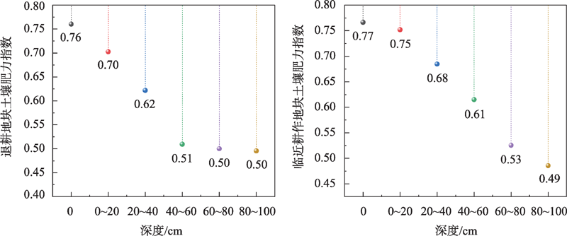
水资源“三条红线”约束促使以农业用水为主的区域逐步开展退地减水措施,有效地保证了用水总量控制指标,也产生部分土地退耕撂荒的土壤质量下降问题。本文以水资源“三条红线”约束下新疆玛纳斯河灌区退耕土壤为研究对象,分析对比了退耕地块(RF)和临近耕作地块(CK)土壤pH值、可溶性总盐(TDS)、有机质(OM)、全氮(TN)、全磷(TP)、碱解氮(AN)和速效钾(AK)7个土壤质量指标,通过构建模糊综合评价模型计算RF和CK土壤肥力指数,分析水资源“三条红线”约束下玛纳斯河灌区退耕土壤质量。结果表明:(1) 退耕地块和临近耕作地块pH在7.18~8.78之间,总体上与土壤深度呈正相关。退耕地块含盐量整体比临近耕作地块高10.84%,盐分主要分布在40~100 cm。(2) 退耕地块的土壤养分整体上低于临近耕作地块,其中碱解氮差异最大,低了22.15%。(3) 退耕地块和临近耕作地块土壤肥力评价指数范围为0.49~0.77,土壤质量均在中等偏上,临近耕作地块比退耕地块肥力指数均值高6.67 %。研究结果可为灌区水资源总量约束下退地方案的实施及土壤质量保护提供理论依据。
黄洲,杨广,苏军,李小龙,刘兵,何新林,乔长录,李鹏飞,王春霞,赵丽. 水资源“三条红线”约束下玛纳斯河灌区退耕土壤质量评价[J]. 干旱区研究, 2022, 39(6): 1942-1951.
HUANG Zhou,YANG Guang,SU Jun,LI Xiaolong,LIU Bing,HE Xinlin,QIAO Changlu,LI Pengfei,WANG Chunxia,ZHAO Li. Soil quality evaluation of returning farmland to Manas River irrigation area under the constraints of the“Three Red Lines” strategy of water resources[J]. Arid Zone Research, 2022, 39(6): 1942-1951.

图1
采样点地理位置"

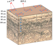
图2
取样布局示意图"

表1
各评价指标隶属度函数曲线转折点取值"
| 转折点 | 含盐量/(g·kg-1) | 碱解氮/(mg·kg-1) | 速效钾/(mg·kg-1) | 有机质/(g·kg-1) | 全氮/(g·kg-1) | 全磷/(g·kg-1) |
|---|---|---|---|---|---|---|
| x1 | 0.52 | 30 | 89.5 | 2.73 | 0.11 | 0.4 |
| x2 | 10.00 | 120 | 210.0 | 17.00 | 1.00 | 0.8 |
表2
pH隶属度函数曲线转折点取值"
| 转折点 | x1 | x2 | x3 | x4 |
|---|---|---|---|---|
| 4 | 6.5 | 8 | 9 |
表3
土壤肥力指标的统计特征值"
| 指标 | 土地状态 | 平均值 | 标准差 | 最小值 | 最大值 | 变异系数/% |
|---|---|---|---|---|---|---|
| pH | RF | 7.82 | 0.44 | 7.18 | 8.78 | 5.58 |
| CK | 7.86 | 0.32 | 7.23 | 8.63 | 4.02 | |
| 含盐量/(g·kg-1) | RF | 2.76 | 2.95 | 0.22 | 12.47 | 107.01 |
| CK | 2.49 | 1.82 | 0.48 | 7.97 | 73.06 | |
| 碱解氮/(mg·kg-1) | RF | 37.07 | 22.42 | 8.80 | 65.03 | 60.47 |
| CK | 47.62 | 29.48 | 7.5 | 90.67 | 61.9 | |
| 速效钾/(mg·kg-1) | RF | 262.53 | 143.13 | 69.17 | 607.70 | 54.52 |
| CK | 243.16 | 90.88 | 93.57 | 556.2 | 37.37 | |
| 有机质/(g·kg-1) | RF | 7.30 | 3.84 | 1.29 | 19.44 | 52.61 |
| CK | 7.80 | 3.40 | 2.47 | 14.93 | 43.63 | |
| 全氮/(g·kg-1) | RF | 0.37 | 0.21 | 0.01 | 0.98 | 56.55 |
| CK | 0.47 | 0.22 | 0.09 | 0.98 | 47.83 | |
| 全磷/(g·kg-1) | RF | 0.70 | 0.15 | 0.40 | 0.97 | 21.58 |
| CK | 0.76 | 0.12 | 0.38 | 0.97 | 16.39 |
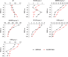
图3
土壤剖面各项养分指标垂直分布"
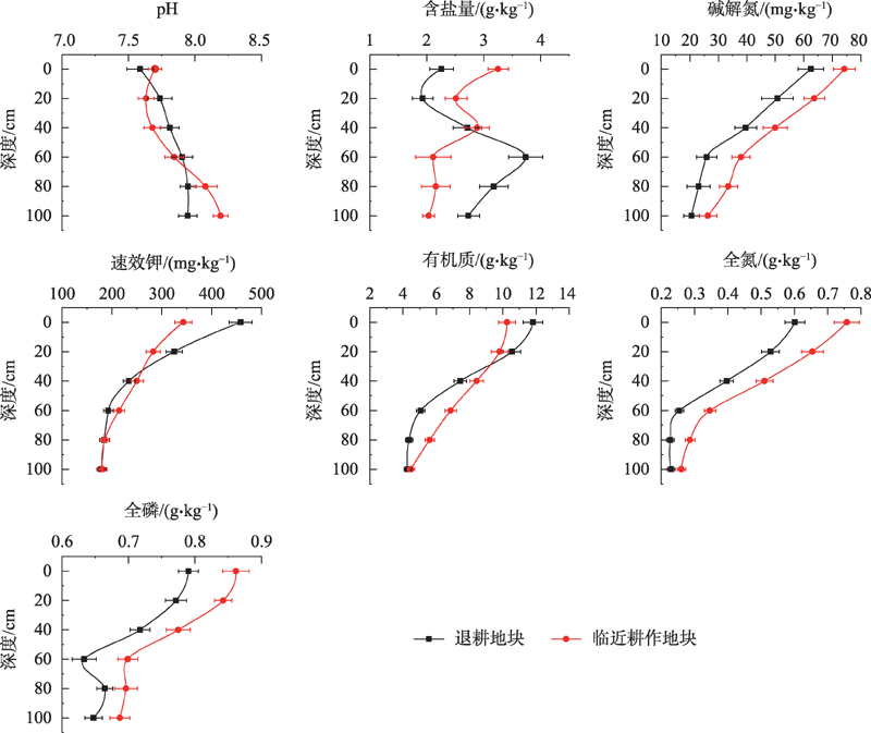
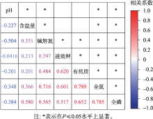
图4
相关系数"
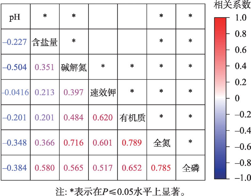
表4
各土壤肥力指标的相关系数平均值和权重系数"
| 肥力指标 | pH值 | 全盐量 | 碱解氮 | 速效钾 | 有机质 | 全氮 | 全磷 |
|---|---|---|---|---|---|---|---|
| 相关系数平均值 | 0.284 | 0.323 | 0.503 | 0.398 | 0.086 | 0.109 | 0.131 |
| 权重系数 | 0.155 | 0.176 | 0.274 | 0.217 | 0.047 | 0.059 | 0.072 |
图5
2个处理不同指标隶属度值"
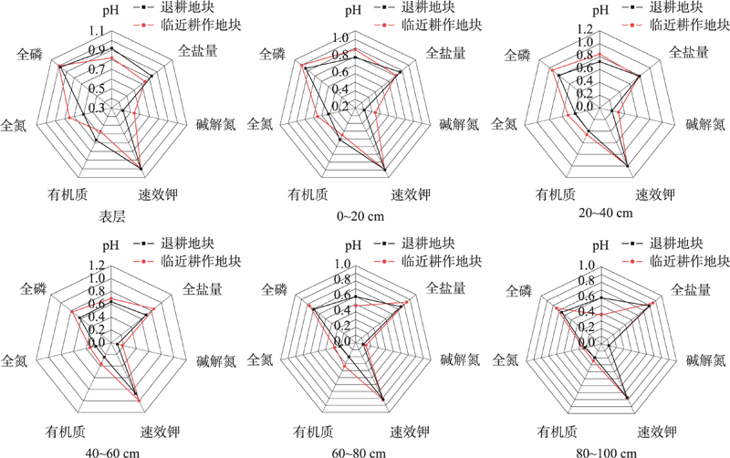
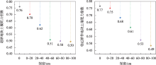
图6
土壤肥力指数"
| [1] | 赵冰琴, 夏栋, 夏露, 等. 向家坝工程扰动区植被恢复土壤质量评价[J]. 中国环境科学, 2020, 40(3): 1224-1234. |
| Zhao Bingqin, Xia Dong, Xia Lu, et al. Assessment of vegetation restoration soil quality in disturbed area in Xiangjiaba hydropower project[J]. China Environmental Science, 2020, 40(3): 1224-1234. ] | |
| [2] | 王雪梅, 柴仲平, 毛东雷, 等. 不同土地利用方式下渭-库绿洲土壤质量评价[J]. 水土保持通报, 2015, 35(4): 319-323. |
| [ Wang Xuemei, Chai Zhongping, Mao Donglei, et al. Evaluation of quality in Weigan-Kuqa River delta oasis under different land use patterns[J]. Bulletin of Soil and Water Conservation, 2015, 35(4): 319-323. ] | |
| [3] |
Mishra G, Marzaioli R, Giri K, et al. Soil quality assessment across different stands in tropical moist deciduous forests of Nagaland, India[J]. Journal of Forestry Research, 2019, 30(4): 1479-1485.
doi: 10.1007/s11676-018-0720-8 |
| [4] |
Vasu D, Tiwari G, Sahoo S, et al. A minimum data set of soil morphological properties for quantifying soil quality in coastal agroecosystems[J]. Catena, 2021, 198: 105042.
doi: 10.1016/j.catena.2020.105042 |
| [5] |
Obade V P, Lal R. Soil quality evaluation under different land management practices[J]. Environmental Earth Sciences, 2014, 72(11): 4531-4549.
doi: 10.1007/s12665-014-3353-z |
| [6] |
赵敬坤, 陈松柏, 李忠意, 等. 模糊综合评价法判断重庆花椒种植区土壤肥力水平[J]. 中国农机化学报, 2021, 42(10): 206-212.
doi: 10.13733/j.jcam.issn.2095-5553.2021.10.29 |
|
[ Zhao Jingkun, Chen Songbai, Li Zhongyi, et al. Soil fertility characteristics in Zanthoxylum bungeanum planting area of Chongqing with the analysis of fuzzy synthetic evaluation[J]. Journal of Chinese Agricultural Mechanization, 2021, 42(10): 206-212. ]
doi: 10.13733/j.jcam.issn.2095-5553.2021.10.29 |
|
| [7] |
赵娜, 孟平, 张劲松, 等. 华北低丘山地不同退耕年限刺槐人工林土壤质量评价[J]. 应用生态学报, 2014, 25(2): 351-358.
pmid: 24830232 |
|
Zhao Na, Meng Ping, Zhang Jinsong, et al. Soil quality assessment of Robinia psedudoacia plantations with various ages in the Grain-for-Green Program in hilly area of North China[J]. Chinese Journal of Applied Ecology, 2014, 25(2): 351-358. ]
pmid: 24830232 |
|
| [8] |
Rahmanipour F, Marzaioli R, Bahrami H A, et al. Assessment of soil quality indices in agricultural lands of Qazvin Province, Iran[J]. Ecological Indicators, 2014, 40(5): 19-26.
doi: 10.1016/j.ecolind.2013.12.003 |
| [9] | 姜艳, 刘东阳, 李健梅, 等. 玛河流域不同连作年限棉田土壤质量分析及综合评价[J]. 干旱地区农业研究, 2021, 39(4): 186-193. |
| [ Jiang Yan, Liu Dongyang, Li Jianmei, et al. Soil quality assessment of continuous cropping cotton fields for different years in Manas River Basin[J]. Agricultural Research in the Arid Areas, 2021, 39(4): 186-193. ] | |
| [10] | 周伟, 王文杰, 张波, 等. 长春城市森林绿地土壤肥力评价[J]. 生态学报, 2017, 37(4): 1211-1220 |
| [ Zhou Wei, Wang Wenjie, Zhang Bo, et al. Soil fertility evaluation for urban forests and green spaces in Changchun City[J]. Acta Ecologica Sinica, 2017, 37(4): 1211-1220. ] | |
| [11] |
郑琦, 王海江, 吕新, 等. 新疆棉田土壤质量综合评价方法[J]. 应用生态学报, 2018, 29(4): 1291-1301.
doi: 10.13287/j.1001-9332.201804.029 |
|
Zheng Qi, Wang Haijiang, Lv Xin, et al. Comprehensive method for evaluating soil quality in cotton fields in Xinjiang, China[J]. Chinese Journal of Applied Ecology, 2018, 29(4): 1291-1301. ]
doi: 10.13287/j.1001-9332.201804.029 |
|
| [12] | 张庆辉, 王贵, 朱晋, 等. 包头南郊污灌区农田表层土壤重金属潜在生态风险综合评价[J]. 西北农林科技大学学报(自然科学版), 2012, 40(7): 181-186, 192. |
| [ Zhang Qinghui, Wang Gui, Zhu Jin, et al. Comprehensive evaluation of potential ecological risk of heavy metals in the surface soil of the farmland in wastewater irrigation area of southern suburbs in Baotou[J]. Journal of Northwest Agriculture and Forestry University (Natural Science Edition), 2012, 40(7): 181-186, 192. ] | |
| [13] | 李小平, 张蒙, 周骞, 等. 乌鲁木齐城市土壤与灰尘粒径空间分布特征[J]. 中国环境监测, 2019, 35(1): 37-43. |
| Li Xiaoping, Zhang Meng, Zhou Qian, et al. Spatial distribution of particle size of urban soil and dust in Urumqi[J]. Environmental Monitoring in China, 2019, 35(1): 37-43. ] | |
| [14] | 乔胜英. 土壤理化性质实验指导书[M]. 武汉: 中国地质大学出版社有限责任公司, 2012: 54-75. |
| Qiao Shengying. Turang Lihua Xingzhi Shiyan Zhidaoshu[M]. Wuhan: China University of Geosciences Press Co, Ltd, 2012: 54-75. ] | |
| [15] | 吴科生, 车宗贤, 包兴国, 等. 河西绿洲灌区灌漠土长期秸秆还田土壤肥力和作物产量特征分析[J]. 草业学报, 2021, 30(12): 59-70. |
| [ Wu Kesheng, Che Zongxian, Bao Xingguo, et al. Analysis of soil fertility and crop yield characteristics following long-term straw return to the field in a Hexi Oasis irrigated area[J]. Acta Prataculturae Sinica, 2021, 30(12): 59-70. ] | |
| [16] | 乔俊, 任惠雯, 费鹏, 等. 山西河津黄河盐碱滩土壤肥力评价[J]. 北方园艺, 2021(16): 102-107. |
| [ Qiao Jun, Ren Huiwen, Fei Peng, et al. Evaluation on soil fertility of yellow river saline alkali flat in Hejin Rwgion of Shanxi[J]. Northern Horticulture, 2021(16): 102-107. ] | |
| [17] | 林圣玉, 李英, 张华明, 等. 鄱阳湖区坡耕地土壤肥力质量评价[J]. 中国水土保持, 2018(11): 60-63, 67. |
| [ Lin Shengyu, Li Ying, Zhang Huaming, et al. Assessment on soil fertility quality of slope farmland in Poyang Lake Area[J]. Soil and Water Conservation in China, 2018(11): 60-63, 67. ] | |
| [18] | 李颖慧, 姜小三, 王振华, 等. 基于土壤肥力和重金属污染风险的农用地土壤质量综合评价研究——以山东省博兴县为例[J]. 土壤通报, 2021, 52(5): 1052-1062. |
| [ Li Yinghui, Jiang Xiaosan, Wang Zhenhua, et al. Comprehensive evaluation of soil quality of agricultural land based on soil fertility and heavy metal pollution risk: A case study of Boxing County, Shandong Province[J]. Chinese Journal of Soil Science, 2021, 52(5): 1052-1062. ] | |
| [19] | 李法虎. 土壤物理化学[M]. 北京: 化学工业出版社, 2006: 235-237. |
| [ Li Fahu. Physical Chemistry of Soil[M]. Beijing: Chemical Industry Press, 2006: 235-237. ] | |
| [20] | 王嫒华, 段增强, 汤英, 等. 碱性大棚土壤剖面pH值与盐分的相关性[J]. 江苏农业科学, 2016, 44(5): 537-540. |
| [ Wang Yuanhua, Duan Zengqiang, Tang Ying, et al. Correlation between pH value and salinity of soil profile in alkaline greenhouse[J]. Jiangsu Agricultural Sciences, 2016, 44(5): 537-540. ] | |
| [21] | 张茹, 李建平, 张翼, 等. 封育对黄土高原草地深层土壤pH的影响[J]. 生态科学, 2020, 39(1): 72-77. |
| Zhang Ru, Li Jianping, Zhang Yi, et al. Effects of fencing on soil pH in deep Loess Plateau grassland[J]. Ecological Science, 2020, 39(1): 72-77. ] | |
| [22] | 钱凤魁, 周阳, 李婉宁, 等. 辽河口翅碱蓬湿地退化区土壤理化性质及生态阈值分析[J]. 土壤通报, 2021, 52(5): 1085-1094. |
| [ Qian Fengkui, Zhou Yang, Li Wanning, et al. Soil characteristics in wetland degradation areas and soil threshold calculation for Suaeda salsa growth in Liaohe Estuary Wetland[J]. Chinese Journal of Soil Science, 2021, 52(5): 1085-1094. ] | |
| [23] | 冯小平, 王义东, 郭长城, 等. 长期垦殖与退化对七里海芦苇沼泽土壤盐分的影响[J]. 湿地科学, 2014, 12(3): 388-394. |
| [ Feng Xiaoping, Wang Yidong, Guo Changcheng, et al. Effects of long-term reclamation and degradation on soil salinity of Phragmites australis marshes in Qilihai Wetlands[J]. Wetland Science, 2014, 12(3): 388-394. ] | |
| [24] | 谭明东, 王振华, 王越, 等. 长期滴灌棉田非灌溉季节土壤盐分累积特征[J]. 干旱区研究, 2022, 39(2): 485-492. |
| [ Tan Mingdong, Wang Zhenhua, Wang Yue, et al. Soil salt accumulation characteristics of long-term drip irrigation in cotton fields during non-irrigation seasons[J]. Arid Zone Research, 2022, 39(2): 485-492. ] | |
| [25] | 李万精, 杨广, 雷杰, 等. 不同矿化度(微)咸水膜下滴灌棉田土壤水盐分布及棉花生长特性研究[J]. 干旱地区农业研究, 2022, 40(3): 95-103. |
| [ Li Wanjing, Yang Guang, Lei Jie, et al. Soil water and salt distribution and cotton growth under film drip irrigation with different water salinity in cotton field[J]. Agricultural Research in the Arid Areas, 2022, 40(3): 95-103. ] | |
| [26] | 马波, 周青云, 张宝忠, 等. 基于HYDRUS-2D的滨海地区膜下滴灌土壤水盐运移模拟研究[J]. 干旱地区农业研究, 2020, 38(5): 182-191. |
| [ Ma Bo, Zhou Qingyun, Zhang Baozhong, et al. Simulation of soil water and salt transport under mulched drip irrigation based on HYDRUS model in coastal area[J]. Agricultural Research in the Arid Areas, 2020, 38(5): 182-191. ] | |
| [27] |
董利军, 李金花, 陈珊, 等. 若尔盖湿地高寒草甸退化过程中土壤有机碳含量变化及成因分析[J]. 植物生态学报, 2021, 45(5): 507-515.
doi: 10.17521/cjpe.2020.0231 |
|
[ Dong Lijun, Li Jinhua, Chen Shan, et al. Changes in soil organic carbon content and their causes during the degradation of alpine meadows in Zoigê Wetland[J]. Chinese Journal of Plant Ecology, 2021, 45(5): 507-515. ]
doi: 10.17521/cjpe.2020.0231 |
|
| [28] | 崔建平, 田立文, 郭仁松, 等. 深翻耕作对连作滴灌棉田土壤含水率及含盐量影响的研究[J]. 中国农学通报, 2014, 30(12): 134-139. |
| [ Cui Jianping, Tian Liwen, Guo Rensong, et al. Effect of deep tilling on soil moisture content and salinity content of drip irrigation cotton continuous cropping[J]. Chinese Agricultural Science Bulletin, 2014, 30(12): 134-139. ] | |
| [29] | 何洪盛, 田青, 王理德, 等. 青土湖退耕地植被群落特征与土壤理化性质分析[J]. 干旱区研究, 2021, 38(1): 223-232. |
| He Hongsheng, Tian Qing, Wang Lide, et al. Study on vegetation community characteristics and soil physical and chemical properties of abandoned land in Qingtu Lake[J]. Arid Zone Research, 2021, 38(1): 223-232. ] | |
| [30] | 王舒, 马岚, 高甲荣, 等. 晋西黄土区土地利用方式对土层有机质变异的影响[J]. 南京林业大学学报: 自然科学版, 2016, 40(5): 81-86. |
| [ Wang Shu, Ma Lan, Gao Jiarong, et al. Effect of land use type on variability of soil organic matter content with soil depth in the loess region of western Shanxi Province[J]. Journal of Nanjing Forestry University (Natural Sciences Edition), 2016, 40(5): 81-86. ] | |
| [31] |
安慧, 杨新国, 刘秉儒, 等. 荒漠草原区弃耕地植被演替过程中植物群落生物量及土壤养分变化[J]. 应用生态学报, 2011, 22(12): 3145-3149.
pmid: 22384580 |
|
[ An Hui, Yang Xinguo, Liu Bingru, et al. Changes of plant community biomass and soil nutrients during the vegetation succession on abandoned cultivated land in desert steppe region[J]. Chinese Journal of Applied Ecology, 2011, 22(12): 3145-3149. ]
pmid: 22384580 |
|
| [32] | 秦宇坤, 李鹏程, 郑苍松, 等. 施氮量对低肥力棉田土壤氮素及棉花养分吸收利用影响[J]. 棉花学报, 2019, 31(3): 242-253. |
| [ Qin Yukun, Li Pengcheng, Zheng Cangsong, et al. Effects of nitrogen application rates on soil nitrogen content, nutrient uptake and utilization of cotton in low fertility fields[J]. Cotton Science, 2019, 31(3): 242-253. ] | |
| [33] | 张田, 许浩, 茹淑华, 等. 不同有机肥中磷在土壤剖面中累积迁移特征与有效性差异[J]. 环境科学, 2017, 38(12): 5247-5255. |
| [ Zhang Tian, Xu Hao, Ru Shuhua, et al. Distribution of phosphorus in soil profiles after continuous application of different fertilizers[J]. Environmental Science, 2017, 38(12): 5247-5255. ] | |
| [34] | 杨昊天, 李新荣, 刘立超, 等. 荒漠草地4种灌木生物量分配特征[J]. 中国沙漠, 2013, 33(5): 1340-1348. |
| [ Yang Haotian, Li Xinrong, Liu Lichao, et al. Biomass allocation patterns of four shrubs in desert grassland[J]. Journal of Desert Research, 2013, 33(5): 1340-1348. ] | |
| [35] |
郝帅, 李发东. 艾比湖流域典型荒漠植被水分利用来源研究[J]. 地理学报, 2021, 76(7): 1649-1661.
doi: 10.11821/dlxb202107006 |
|
[ Hao Shuai, Li Fadong. Water sources of the typical desert vegetation in Ebinur Lake basin[J]. Acta Geographica Sinica, 2021, 76(7): 1649-1661. ]
doi: 10.11821/dlxb202107006 |
|
| [36] |
穆叶赛尔·吐地, 吉力力·阿不都外力, 姜逢清. 天山北坡林沿土壤养分含量的区域差异特征研究[J]. 中国生态农业学报, 2013, 21(5): 580-589.
doi: 10.3724/SP.J.1011.2013.00580 |
|
[ Muyessar Tudi, Jilili Abuduwaili, Jiang Fengqing. Regional differences in soil nutrient content along the forest edge in the northern slope of Tianshan Mountains[J]. Chinese Journal of Eco-Agriculture, 2013, 21(5): 580-589. ]
doi: 10.3724/SP.J.1011.2013.00580 |
|
| [37] | 谭军利, 王林权, 李生秀. 不同灌溉模式下水分养分的运移及其利用[J]. 植物营养与肥料学报, 2005(4): 442-448. |
| [ Tan Junli, Wang Linquan, Li Shengxiu. Movement and utilization of water nutrient under different irrigation patterns[J]. Journal of Plant Nutrition and Fertilizers, 2005(4): 442-448. ] |
| [1] | 张胜, 张涛, 段雯瑜, 徐利, 顾金洋, 张炜, 李思敏. 基于改进方法的承德地表水环境质量评价[J]. 干旱区研究, 2024, 41(1): 50-59. |
| [2] | 杨蕾,璩向宁,马正虎,张矞勋,田媛,何志润. 宁夏阅海湿地水质评价及其空间差异性研究[J]. 干旱区研究, 2021, 38(3): 640-649. |
| [3] | 朱薇, 周宏飞, 李兰海, 闫英杰. 哈萨克斯坦农业水土资源承载力评价及其影响因素识别[J]. 干旱区研究, 2020, 37(1): 254-263. |
| [4] | 董莉丽, 郑粉莉. 黄土丘陵沟壑区植被类型对土壤质量的影响[J]. 干旱区研究, 2011, 28(4): 616-621. |
|
||