Arid Zone Research ›› 2021, Vol. 38 ›› Issue (6): 1659-1667.doi: 10.13866/j.azr.2021.06.17
• Plant and Plant Physiology • Previous Articles Next Articles
YANG Xuefeng1,2( ),YE Mao1,2,Munire Maimaiti1,2
Received:2021-03-07
Revised:2021-05-20
Online:2021-11-15
Published:2021-11-29
YANG Xuefeng,YE Mao,Munire Maimaiti. Structural parameter acquisition of Populus euphratica by WorldView-2 remote sensing image[J].Arid Zone Research, 2021, 38(6): 1659-1667.
Add to citation manager EndNote|Reference Manager|ProCite|BibTeX|RefWorks
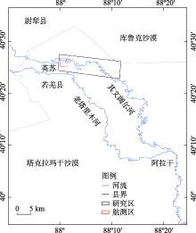
Fig. 1
Schematic diagram of study area"
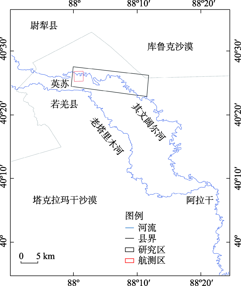
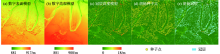
Fig. 2
Extraction process of Populus euphratica canopy based on UAV"
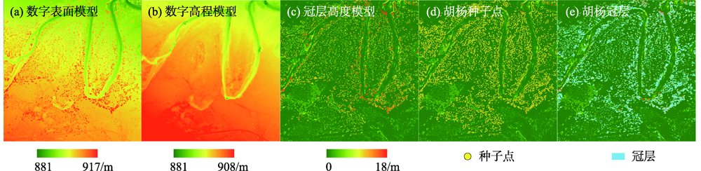
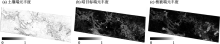
Fig. 3
Result of FCLS linear spectral unmix of WorldView-2"

Tab. 1
Feature list of tree height regression"
| 特征 | 相关系数 | 特征 | 相关系数 |
|---|---|---|---|
| 亮度(Brightness) | -0.50 | GLCM同质性(GLCM.Homg) | 0.47 |
| 均值(GLCM_Mean) | -0.45 | GLCM熵(GLCM.Entropy) | 0.46 |
| 标准差(GLCM_StdDe) | -0.56 | GLCM异质性(GLCM.Dissi) | -0.45 |
| NDVI均值(Mean_Ndvi) | -0.54 | 树冠周长(Border.Len) | 0.47 |
| Red最大值(Mean_Red) | -0.57 | 树冠面积(Area) | 0.45 |
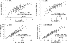
Fig. 4
Comparisions of structural parameters between UAV and WorldView-2 measured data"

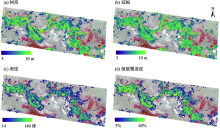
Fig. 5
Spatial distribution of structure parameters of Populus euphratica"

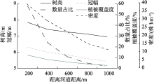
Fig. 6
Distance analysis of structure parameters of Populus euphratica"


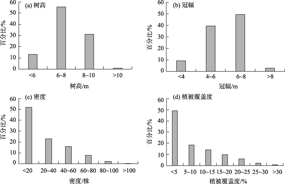
Fig. 7
Percentage composition of structure parameters of Populus euphratica"
| [1] | Pedroni L. Forest ecosystems, forest management and the global carbon cycle[J]. Forest Ecology & Management, 1997, 97(1):91-92. |
| [2] | Schrter M, Bonn A, Klotz S, et al. Atlas of ecosystem services: Drivers, risks, and societal responses[M]. Berlin: Springer, 2019. |
| [3] | Rogass C, Kaufmann H. Remote sensing-advanced techniques and platforms[M]. NewYork: Intechopen, 2012. |
| [4] |
Hudak A, Crookston N, Evans J, et al. Nearest neighbour imputation of species-level, plot-scale forest structure attributes from lidar data[J]. Remote Sensing of Environment, 2008, 112:2232-2245.
doi: 10.1016/j.rse.2007.10.009 |
| [5] |
Hyyppä J, Hyyppä H, Leckie D, et al. Review of methods of small-footprint airborne laser scanning for extracting forest inventory data in boreal forests[J]. International Journal of Remote Sensing, 2008, 29(5):1339-1336.
doi: 10.1080/01431160701736489 |
| [6] | 解金卫, 索志勇, 李真芳, 等. 基于PolInSAR的植被区高精度数字表面模型反演方法[J]. 电子与信息学报, 2019, 41(2):44-52. |
| [ Xie Jinwei, Suo Zhiyong, Li Zhenfang, et al. High-precision digital surface model inversion approach in forest region based on PolInSAR[J]. Journal of Electronics & Information Technology, 2019, 41(2):44-52. ] | |
| [7] | Marivi Tello, Victor Cazcarra-Bes, Matteo Pardini, et al. Forest structure characterization from SAR tomography at L-band[J]. IEEE Journal of Selected Topics in Applied Earth Observations & Remote Sensing, 2018, 11(10):3402-3414. |
| [8] | 蔡耀通, 林辉, 孙华, 等. 基于TanDEM-X数据的林分平均高反演方法研究[J]. 西南林业大学学报, 2019, 39(5):110-117. |
| [ Cai Yaotong, Lin Hui, Sun Hua, et al. Stand allocation high inversion method based on TanDEM-X data[J]. Journal of Southwest Forestry University, 2019, 39(5):110-117. ] | |
| [9] | 董立新. 林分平均高度卫星遥感新进展[J]. 遥感技术与应用, 2016, 31(5):833-845. |
| [ Dong Lixin. New development of forest canopy height remote sensing[J]. Remote Sensing Technology and Application, 2016, 31(5):833-845. ] | |
| [10] | 陈曦, 包安明, 古丽·加帕尔, 等. 塔里木河流域生态系统综合检测与评估[M]. 北京: 科学出版社, 2016. |
| [ Chen Xi, Bao Anming, Guli Jiapaer. Comprehensive Monitoring and Assessment of Ecosystem in Tarim River Basin[M]. Beijing: Science Press, 2016. ] | |
| [11] | 陈亚宁, 张小雷, 祝向民, 等. 新疆塔里木河下游断流河道输水的生态效应分析[J]. 中国科学: 地球科学, 2004, 8(5):475-482. |
| [ Chen Yaning, Zhang Xiaolei, Zhu Xiangmin, et al. Analysis on ecological effect of water conveyance in the lower reaches of Tarim River in Xinjiang[J]. Scientia Sinica (Terrae), 2004, 8(5):475-482. ] | |
| [12] | 李霞, 侯平, 董新光, 等. 塔里木河下游断流区胡杨密度调查与分析[J]. 新疆农业大学学报, 2003, 26(4):44-47. |
| [ Li Xia, Hou Ping, Dong Xinguang, et al. Investigation and analysis on the population density of Populus euphratica in zero flow lower reaches of Tarim River[J]. Journal of Xinjiang Agricultural University, 2003, 26(4):44-47. ] | |
| [13] | 朱长明, 李均力, 沈占锋, 等. 基于MODIS密集时间序列数据的塔里木河下游植被活动过程监测[J]. 资源科学, 2019, 41(3):179-188. |
| [ Zhu Changming, Li Junli, Shen Zhanfeng, et al. Spatiotemporal dynamics of vegetation activities in the lower reach of the Tarim River based on MODIS intensive time series data[J]. Resources Science, 2019, 41(3):179-188. ] | |
| [14] |
黄粤, 包安明, 王士飞, 等. 间歇性输水影响下的2001—2011年塔里木河下游生态环境变化[J]. 地理学报, 2013, 68(9):1251-1262.
doi: 10.11821/dlxb201309008 |
|
[ Huang Yue, Bao Anming, Wang Shifei, et al. Eco-environmental change in the lower Tarim River under the influence of intermittent water transport[J]. Acta Geographica Sinica, 2013, 68(9):1251-1262. ]
doi: 10.11821/dlxb201309008 |
|
| [15] | 管文轲, 韦红, 钟家骅, 等. 塔里木河流域植被覆盖变化的遥感监测[J]. 水土保持通报, 2018, 38(5):244-248, 260. |
| [ Guan Wenke, Wei Hong, Zhong Jiahua, et al. Remote sensing monitoring of vegetation cover change in Tarim River basin[J]. Bulletin of Soil and Water Conservation, 2018, 38(5):244-248, 260. ] | |
| [16] | 牛婷, 李霞. 塔里木河下游植被恢复遥感模型建立[J]. 国土资源遥感, 2008, 21(2):79-83. |
| [ Niu Ting, Li Xia. A remote sensing model for vegetation restoration in the lower valley of the Tarim River[J]. Remote Sensing for Land & Resources, 2008, 21(2):79-83. ] | |
| [17] |
Obanawa H S, Hayakawa Y, Saito H, et al. Comparison of DSMs derived from UAV-SFM method and terrestrial laser scanning[J]. Journal of the Japan society of photogrammetry and remote sensing, 2014, 53(2):67-74.
doi: 10.4287/jsprs.53.67 |
| [18] | 闫东阳, 明冬萍. 基于自动多种子区域生长的遥感影像面向对象分割方法[J]. 工程科学学报, 2017, 66(11):132-139. |
| [ Yan Dongyang, Ming Dongping. Object-oriented remote sensing image segmentation based on automatic multi-seed region growing algorithm[J]. Journal of University of Science and Technology, 2017, 66(11):132-139. ] | |
| [19] |
Xu X, Tong X, Plaza A, et al. Using linear spectral unmixing for subpixel mapping of hyperspectral imagery: A quantitative assessment[J]. IEEE Journal of Selected Topics in Applied Earth Observations and Remote Sensing, 2017, 10(4):1589-1600.
doi: 10.1109/JSTARS.4609443 |
| [20] |
Gudex-Cross D, Pontius J, Adams A. Enhanced forest cover mapping using spectral unmixing and object-based classification of multi-temporal Landsat imagery[J]. Remote Sensing of Environment, 2017, 196:193-204.
doi: 10.1016/j.rse.2017.05.006 |
| [21] | 滑永春, 李增元, 高志海. 面向对象分割与混合像元分解相结合提取沙化土地信息[J]. 干旱区研究, 2020, 37(5):254-260. |
| [ Hua Yongchun, Li Zengyuan, Gao Zhihai. Extraction of sand information using object-oriented segmentation combined with the decomposition of mixed pixels[J]. Arid Zone Research, 2020, 37(5):254-260. ] | |
| [22] |
Yu J, Chen D, Lin Y, et al. Comparison of linear and nonlinear spectral unmixing approaches: A case study with multispectral TM imagery[J]. International Journal Of Remote Sensing, 2017, 38(3-4):773-795.
doi: 10.1080/01431161.2016.1271475 |
| [23] | 郄广平. 高分辨率遥感影像的森林结构参数反演[D]. 长沙: 中南林业科技大学, 2011. |
| [ Qie Guangping. The Research on Forestry Factor by High-Resolution Remote Sensing Image[D]. Changsha: Central South University of Forestry and Technology, 2011. ] | |
| [24] |
Donoghue D N M, Watt P J. Using LiDAR to compare forest height estimates from IKONOS and Landsat ETM+ data in Sitka spruce plantation forests[J]. International Journal of Remote Sensing, 2006, 27(11):2161-2175.
doi: 10.1080/01431160500396493 |
| [25] |
Chen G, Hay G J, Castilla G, et al. A multiscale geographic object-based image analysis to estimate lidar-measured forest canopy height using Quick bird imagery[J]. International Journal of Geographical Information Science, 2011, 25(6):877-893.
doi: 10.1080/13658816.2010.496729 |
| [26] |
Gomes M F, Maillard P. Using spectral and textural features from Rapid Eye images to estimate age and structural parameters of Cerrado vegetation[J]. International journal of remote sensing, 2015, 36(11-12):3058-3076.
doi: 10.1080/01431161.2015.1055604 |
| [27] | Rodrigues é O, Pinheiro V H A, Liatsis P, et al. Machine learning in the prediction of cardiac epicardial and mediastinal fat volumes[J]. Computers in Biology & Medicine, 2017, 89(10):520-529. |
| [28] | 赵金, 陈曦, 古丽·加帕尔, 等. 塔里木河荒漠植被光谱可分性模拟[J]. 中国沙漠, 2009, 29(2):270-278. |
| [ Zhao Jin, Chen Xi, Guli Japaer, et al. Spectral discrimination of desert vegetation int the Tarim basin[J]. Journal of Desert Research, 2009, 29(2):270-278. ] | |
| [29] | 胡潭高, 徐俊锋, 张登荣, 等. 自适应阈值的多光谱遥感影像软硬分类方法研究[J]. 光谱学与光谱分析, 2013, 33(4):1038-1042. |
| [ Hu Tangao, Xu Junfeng, Zhang Dengrong, et al. Hard and soft classification method of multi-spectral remote sensing image based on adaptive thresholds[J]. Spectroscopy and Spectral Analysis, 2013, 33(4):1038-1042. ] | |
| [30] | 陈绪志. 基于线性光谱混合模型的植被丰度遥感信息提取——以梅江流域为例[D]. 南昌: 江西师范大学, 2012. |
| [ Chen Xuzhi. Remote Sensing Information Extraction of Vegetation Abundance based on Linear Spectral Mixed model: A case study of Meijiang River Basin[D]. Nanchang: Jiangxi Normal University, 2012. ] | |
| [31] | 封静, 季民河, 胡笳. 基于高分分辨遥感的红树林郁闭度光谱混合分析[C]// 第十七届中国遥感大会摘要集. 中国遥感委员会, 2010. |
| [ Feng Jing, Ji Minhe, Hu Jia. Spectral mixing analysis of mangrove canopy density based on high resolution remote sensing[C]// Summary of the 17th China Remote Sensing Conference. Chinese National Committee for Remote Sensing, 2010. ] | |
| [32] |
Lu Dengsheng, Moran Emilio, Batistella Mateus. Linear mixture model applied to Amazonian vegetation classification[J]. Remote Sensing of Environment, 2003, 87(4):456-469.
doi: 10.1016/j.rse.2002.06.001 |
| [33] | 李晓靖. 基于高分影像的面向对象分类与单木树冠提取研究[D]. 北京: 北京林业大学, 2017. |
| [ Li Xiaojing. Study on Object-oriented Classification and Individual Tree Crown Extraction based on High Resolution Imagery[D]. Beijing: Beijing Forestry University, 2017. ] | |
| [34] | 杨礼. 融合UAV遥感影像与SFM点云的树木识别及参数提取[D]. 焦作: 河南理工大学, 2018. |
| [ Yang Li. Tree Parameters Extraction using UAV Remote Sensing Image and SFM Point Cloud[D]. Jiaozuo: Henan Polytechnic University, 2018. ] | |
| [35] | 邓潮洲, 张希明, 李利, 等. 塔里木河下游胡杨群落特征及种群结构分析[J]. 中国沙漠, 2010, 30(3):589-595. |
| [ Deng Chaozhou, Zhang Ximing, Li Li, et al. Community characteristics and population structure of Populus euphratica Oliv in lower reaches of Tarim River[J]. Journal of Desert Research, 2010, 30(3):589-595. ] | |
| [36] | 张绘芳, 李霞. 塔里木河下游胡杨种群空间分布格局分析[J]. 西北植物学报, 2006, 26(10):2125-2130. |
| [ Zhang Huifang, Li Xia. Spatial distribution pattern of Populus euphratica populations in the lower reaches of Tarim River[J]. Acta Botanica Boreali-Occidentalia Sinica, 2006, 26(10):2125-2130. ] |
| [1] | MA Jilong, SHI Junhui, WANG Xinying, Aliya BAIDOURELA, LIU Maoxiu, Aijier ABULA. Effects of flood overflow on soil organic carbon and active components of Populus euphratica forest in the middle reaches of the Tarim River [J]. Arid Zone Research, 2023, 40(8): 1248-1257. |
| [2] | CHENG Qian, Tayierjiang AISHAN, Umut HALIK, WANG Xinying. Hollow tree characteristics of different aged Populus euphratica forests in the middle reaches of the Tarim River [J]. Arid Zone Research, 2023, 40(2): 247-256. |
| [3] | MA Junmei, MA Jianping, MAN Duoqing, GUO Chunxiu, ZHANG Yunian, ZHAO Peng, WANG Fei, LI Yuanxing. Distribution and regeneration characteristics of natural Populus euphratica forests in Hexi Corridor and their relationship with soil factors [J]. Arid Zone Research, 2023, 40(2): 224-234. |
| [4] | WANG Zikang,JIAO Ayong,LING Hongbo,SHAN Qianjuan,ZHANG Guangpeng,WANG Wenqi. Characteristics of Populus euphratica root under various irrigation modes [J]. Arid Zone Research, 2022, 39(4): 1133-1142. |
| [5] | WEN Jun,ZHAO Chengzhang,LI Qun,ZHAO Lianchun. Studies of correlation between the transpiration rate and leaf traits of Populus euphratica in the middle reaches of the Heihe River wetland [J]. Arid Zone Research, 2021, 38(2): 429-437. |
|
||