Arid Zone Research ›› 2024, Vol. 41 ›› Issue (5): 856-864.doi: 10.13866/j.azr.2024.05.13
• Ecology and Environment • Previous Articles Next Articles
XU Jing1( ), WANG Deren2
Received:2023-12-08
Revised:2024-03-20
Online:2024-05-15
Published:2024-05-29
XU Jing, WANG Deren. Construction and optimization of ecological network of Lanzhou-Xining urban agglomeration based on adaptive cycle[J].Arid Zone Research, 2024, 41(5): 856-864.
Add to citation manager EndNote|Reference Manager|ProCite|BibTeX|RefWorks
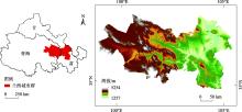
Fig. 1
Geographical location of the study area"

Tab. 1
Data overview"
| 数据名称 | 年份 | 类型 | 分辨率 | 来源 |
|---|---|---|---|---|
| 土地利用 | 2020年 | 栅格 | 30 m | GlobeLand 30( |
| 年均气温 | 2020年 | 栅格 | 1 km | 中国科学院资源环境科学与数据中心( |
| 年均降水 | 2020年 | 栅格 | 1 km | |
| 植被覆盖度 | 2021年 | 栅格 | 1 km | |
| 人口分布 | 2019年 | 栅格 | 1 km | |
| GDP分布 | 2019年 | 栅格 | 1 km | |
| 土壤数据 | 1995年 | 栅格 | 1 km | 世界土壤数据库(HWSD V1.2) |
| 数字高程 | 2009年 | 栅格 | 30 m | 地理空间数据云GDEMV3 30M ( |
| 道路、河流和居民地 | 2021年 | 矢量 | - | 全国地理信息资源目录服务系统( |
Tab. 2
Ecological resistance index system based on potential-connectivity-resilience criteria"
| 准则 | 指标 | 类型 | 权重 |
|---|---|---|---|
| 潜力 | 坡度 | 正向 | 0.018 |
| 土地利用类型 | 正向 | 0.192 | |
| 年均降水 | 负向 | 0.067 | |
| 年均气温 | 负向 | 0.061 | |
| 水源涵养 | 负向 | 0.043 | |
| 土壤保持 | 负向 | 0.111 | |
| 生境质量 | 负向 | 0.051 | |
| 高程 | 正向 | 0.056 | |
| 连通度 | Shannon多样性 | 负向 | 0.089 |
| 距建设用地距离 | 负向 | 0.007 | |
| 分割指数 | 负向 | 0.061 | |
| 分离度 | 正向 | 0.045 | |
| 韧性 | 平均邻近指数 | 负向 | 0.021 |
| 人口密度 | 正向 | 0.012 | |
| GDP | 正向 | 0.015 | |
| 稳定性指数 | 负向 | 0.078 | |
| NDVI指数 | 负向 | 0.124 | |
| 结构稳定性指数 | 负向 | 0.005 |
Tab. 3
Landscape pattern index"
| 粒度/m | 斑块数量/个 | 斑块密度 /(个·km-2) | 景观形状指数/% | 蔓延度指数/% | 连接度指数/% | 内聚力指数 |
|---|---|---|---|---|---|---|
| 50 | 18376 | 0.18 | 24.01 | 80.29 | 0.27 | 99.98 |
| 100 | 9934 | 0.10 | 19.95 | 79.13 | 0.24 | 99.96 |
| 200 | 4455 | 0.04 | 15.62 | 77.80 | 0.21 | 99.93 |
| 300 | 2698 | 0.03 | 13.15 | 77.00 | 0.18 | 99.91 |
| 400 | 1960 | 0.02 | 11.60 | 76.46 | 0.17 | 99.88 |
| 600 | 1148 | 0.01 | 9.63 | 75.72 | 0.17 | 99.83 |
| 800 | 751 | 0.01 | 8.48 | 75.13 | 0.14 | 99.80 |
| 1000 | 544 | 0.01 | 7.66 | 74.63 | 0.11 | 99.76 |
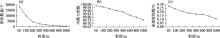
Fig. 2
The connectivity index of ecological landscape under different granularities"

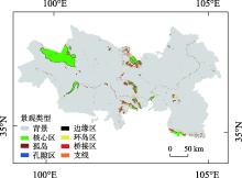
Fig. 3
Identification of MSPA"

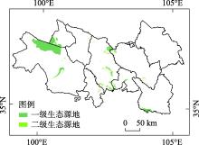
Fig. 4
The division of ecological sources"

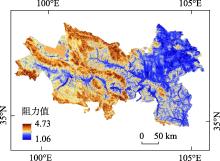
Fig. 5
Ecological resistance surface"

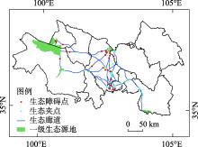
Fig. 6
Spatial distribution of ecological corridors and key ecological points"

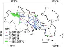
Fig. 7
Optimized pattern of ecological network"

Tab. 4
Structure index of ecological network before and after optimization"
| 廊道数/条 | α指数 | β指数 | γ指数 | |
|---|---|---|---|---|
| 优化前 | 40 | 0.60 | 2.00 | 0.74 |
| 优化后 | 73 | 0.71 | 2.28 | 0.81 |
| [1] | 李可昕, 胡宏, 赵慧敏. 基于适应性循环理论与压力-状态-响应框架的区域社会-生态系统演进研究[J]. 生态学报, 2022, 42(24): 10164-10179. |
| [Li Kexin, Hu Hong, Zhao Huimin. Evolution analysis of regional social-ecological systems based on adaptive cycle theory and Pressure-State-Response framework[J]. Acta Ecologica Sinica, 2022, 42(24): 10164-10179.] | |
| [2] | 陆禹, 佘济云, 陈彩虹, 等. 基于粒度反推法的景观生态安全格局优化——以海口市秀英区为例[J]. 生态学报, 2015, 35(19): 6384-6393. |
| [Lu Yu, She Jiyun, Chen Caihong, et al. Landscape ecological security pattern optimization based on the granularity inverse method: A case study in Xiuying District, Haikou[J]. Acta Ecologica Sinica, 2015, 35(19): 6384-6393.] | |
| [3] | 李权荃, 金晓斌, 张晓琳, 等. 基于景观生态学原理的生态网络构建方法比较与评价[J]. 生态学报, 2023, 43(4): 1461-1473. |
| [Li Quanquan, Jin Xiaobin, Zhang Xiaolin, et al. Comparison and evaluation of the ecological network construction method based on principles of landscape ecology[J]. Acta Ecologica Sinica, 2023, 43(4): 1461-1473.] | |
| [4] |
杜箫宇, 吕飞南, 王春雨, 等. 基于MSPA-Conefor-MCR的县域尺度生态网络构建——以延庆区为例[J]. 应用生态学报, 2023, 34(4): 1073-1082.
doi: 10.13287/j.1001-9332.202303.023 |
| [Du Xiaoyu, Lyu Feinan, Wang Chunyu, et al. Construction of ecological network based on MSPA-Conefor-MCR at the country scale: A case study in Yanqing District, Beijing, China[J]. Chinese Journal of Applied Ecology, 2023, 34(4): 1073-1082.] | |
| [5] | Yuan Y, Wang J, Qiao N, et al. Identifying ecological strategic points based on multi-functional ecological networks: A case study of Changzhi City, China[J]. Applied Geography, 2023, 157: 103002. |
| [6] | Shi F, Liu S, Sun Y, et al. Ecological network construction of the heterogeneous agro-pastoral areas in the upper Yellow River basin[J]. Agriculture, Ecosystems & Environment, 2020, 302: 107069. |
| [7] | Ma J, Yu Q, Wang H, et al. Construction and optimization of wetland landscape ecological network in Dongying City, China[J]. Land, 2022, 11(8): 1226. |
| [8] | 秦子博, 玄锦, 黄柳菁, 等. 基于MSPA和MCR模型的海岛型城市生态网络构建——以福建省平潭岛为例[J]. 水土保持研究, 2023, 30(2): 303-311. |
| [Qin Zibo, Xuan Jin, Huang Liujing, et al. Ecological network construction of sea-island city based on MSPA and MCR model: A case study of Pingtan Island in Fujian Province[J]. Research of Soil and Water Conservation, 2023, 30(2): 303-311.] | |
| [9] | Yu Q, Yue D P, Wang Y H, et al. Optimization of ecological node layout and stability analysis of ecological network in desert oasis: A typical case study of ecological fragile zone located at Deng Kou County (Inner Mongolia)[J]. Ecological Indicators, 2018, 84: 304-318. |
| [10] | 陈艳, 马月伟, 潘健峰, 等. 顾及石漠化敏感性的山地型城市生态网络构建——以云南省曲靖市为例[J]. 生态学报, 2023, 43(17): 1-12. |
| [Chen Yan, Ma Yuewei, Pan Jianfeng, et al. Ecological network construction of mountainous cities considering rocky desertification sensitivity: A case study of Qujing City, Yunnan Province[J]. Acta Ecologica Sinica, 2023, 43(17): 1-12.] | |
| [11] | Li Y Y, Zhang Y Z, Jiang Z Y, et al. Integrating morphological spatial pattern analysis and the minimal cumulative resistance model to optimize urban ecological networks: A case study in Shenzhen City, China[J]. Ecological Processes, 2021, 10: 1-15. |
| [12] | An Y, Liu S, Sun Y, et al. Construction and optimization of an ecological network based on morphological spatial pattern analysis and circuit theory[J]. Landscape Ecology, 2021, 36: 2059-2076. |
| [13] | 吴未, 张敏, 许丽萍, 等. 基于不同网络构建方法的生境网络优化研究——以苏锡常地区白鹭为例[J]. 生态学报, 2016, 36(3): 844-853. |
| [Wu Wei, Zhang Min, Xu Liping, et al. Habitat network optimization based on different network building methods: A case study of Egretta garzetta in the Su-Xi-Chang area[J]. Acta Ecologica Sinica, 2016, 36(3): 844-853.] | |
| [14] | Beaujean S, Nor A N M, Brewer T, et al. A multistep approach to improving connectivity and co-use of spatial ecological networks in cities[J]. Landscape Ecology, 2021, 36: 2077-2093. |
| [15] |
张平江, 党国锋. 基于MCR模型与蚁群算法的洮河流域生态安全格局构建[J]. 生态环境学报, 2023, 32(3): 481-491.
doi: 10.16258/j.cnki.1674-5906.2023.03.006 |
| [Zhang Pingjiang, Dang Guofeng. Construction of ecological security pattern of Tao River Basin based on MCR model and ant colony algorithm[J]. Ecology and Environmental Sciences, 2023, 32(3): 481-491.] | |
| [16] | Lumia G, Pratico S, Di Fazio S, et al. Combined use of urban Atlas and Corine land cover datasets for the implementation of an ecological network using graph theory within a multi-species approach[J]. Ecological Indicators, 2023, 148: 110150. |
| [17] | Gao Y, Ma L, Liu J, et al. Constructing ecological networks based on habitat quality assessment: A case study of Changzhou, China[J]. Scientific Reports, 2017, 7(1): 46073. |
| [18] | Xie J, Xie B, Zhou K, et al. Impacts of landscape pattern on ecological network evolution in Changsha-Zhuzhou-Xiangtan Urban Agglomeration, China[J]. Ecological Indicators, 2022, 145: 109716. |
| [19] | Newton A C, Hodder K, Cantarello E, et al. Cost-benefit analysis of ecological networks assessed through spatial analysis of ecosystem services[J]. Journal of Applied Ecology, 2012, 49(3): 571-580. |
| [20] | 景培清, 张东海, 艾泽民, 等. 基于格局-过程生态适应性循环三维框架的自然景观生态风险评价——以黄土高原为例[J]. 生态学报, 2021, 41(17): 7026-7036. |
| [Jing Peiqing, Zhang Donghai, Ai Zemin, et al. Natural landscape ecological risk assessment based on the three-dimensional framework of pattern-process ecological adaptability cycle: A case in Loess Plateau[J]. Acta Ecologica Sinica, 2021, 41(17): 7026-7036.] | |
| [21] |
杨庆媛, 张浩哲, 唐强. 基于适应性循环模型的重庆市国土空间生态修复分区[J]. 地理学报, 2022, 77(10): 2583-2598.
doi: 10.11821/dlxb202210011 |
|
[Yang Qingyuan, Zhang Haozhe, Tang Qiang. Ecological restoration zoning of territorial space in Chongqing City based on adaptive cycle model[J]. Acta Geographica Sinica, 2022, 77(10): 2583-2598.]
doi: 10.11821/dlxb202210011 |
|
| [22] | 范冬萍, 何德贵. 基于CAS理论的社会生态系统适应性治理进路分析[J]. 学术研究, 2018(12): 6-11, 177. |
| [Fan Dongping, He Degui. Analysis of adaptive governance pathways in social-ecological systems based on CAS theory[J]. Academic Research, 2018 (12): 6-11, 177.] | |
| [23] |
王凯歌, 郑慧慧, 徐艳, 等. 社会-生态系统结构研究进展与网络化探索[J]. 地理科学进展, 2022, 41(12): 2383-2395.
doi: 10.18306/dlkxjz.2022.12.015 |
|
[Wang Kaige, Zheng Huihui, Xu Yan, et al. Research progress of social-ecological system structure and networking exploration[J]. Progress in Geography, 2022, 41(12): 2383-2395.]
doi: 10.18306/dlkxjz.2022.12.015 |
|
| [24] | Sundstrom S M, Allen C R. The adaptive cycle: More than a metaphor[J]. Ecological Complexity, 2019, 39: 100767. |
| [25] | 袁媛, 冯四清, 武立争. 基于生态安全格局的县域国土空间生态保护修复研究——以皖南地区东至县为例[J]. 合肥工业大学学报(社会科学版), 2022, 36(1): 108-118. |
| [Yuan Yuan, Feng Siqing, Wu Lizheng. Ecological protection and restoration of county territorial space based on ecological security pattern: A case study of Dongzhi County, southern Anhui Province[J]. Journal of Hefei University of Technology (Social Science), 2022, 36(1): 108-118.] | |
| [26] | Iwanowski M. Morphological classification of binary image’s pixels[J]. Machine Graphics and Vision, 2009, 18(2): 155-173. |
| [27] | 张美丽, 齐跃普, 张利, 等. 基于Linkage Mapper与粒度反推法的太行山中北段生态节点识别与分析: 以河北省阜平县为例[J]. 生态与农村环境学报, 2020, 36(12): 1569-1578. |
| [Zhang Meili, Qi Yuepu, Zhang Li, et al. Identification and analysis of ecological nodes based on linkage mapper and granularity inverse method in the middle and northern sections of Taihang Mountain: A case study of Fuping County, Hebei Province[J]. Journal of Ecology and Rural Environment, 2020, 36(12): 1569-1578.] | |
| [28] | 马超, 陈英, 张金龙, 等. 河西走廊生态安全格局构建与优化研究[J]. 生态科学, 2023, 42(1): 206-214. |
| [Ma Chao, Chen Ying, Zhang Jinlong, et al. Construction and optimization of ecological security pattern in Hexi Corridor[J]. Ecological Science, 2023, 42(1): 206-214.] | |
| [29] | 张玉娇, 曾杰, 陈万旭, 等. 基于适应性循环的丹江口库区生态风险评价[J]. 水土保持研究, 2022, 29(1): 349-360. |
| [Zhang Yujiao, Zeng Jie, Chen Wanxu, et al. Assessment on ecological risk of Danjiangkou Reservoir Area based on adaptive cycle[J]. Research of Soil and Water Conservation, 2022, 29(1): 349-360.] | |
| [30] |
刘焱序, 王仰麟, 彭建, 等. 基于生态适应性循环三维框架的城市景观生态风险评价[J]. 地理学报, 2015, 70(7): 1052-1067.
doi: 10.11821/dlxb201507003 |
|
[Liu Yanxu, Wang Yanglin, Peng Jian, et al. Urban landscape ecological risk assessment based on the 3D framework of adaptive cycle[J]. Acta Geographica Sinica, 2015, 70(7): 1052-1067.]
doi: 10.11821/dlxb201507003 |
|
| [31] | 张晓东, 赵志鹏, 赵银鑫, 等. 银川市景观生态风险评价与生态安全格局优化构建[J]. 干旱区地理, 2022, 45(5): 1626-1636. |
| [Zhang Xiaodong, Zhao Zhipeng, Zhao Yinxin, et al. Landscape ecological risk assessment and ecological security pattern optimization construction in Yinchuan City[J]. Arid Land Geography, 2022, 45(5): 1626-1636.] | |
| [32] |
黄木易, 岳文泽, 冯少茹, 等. 基于MCR模型的大别山核心区生态安全格局异质性及优化[J]. 自然资源学报, 2019, 34(4): 771-784.
doi: 10.31497/zrzyxb.20190408 |
|
[Huang Muyi, Yue Wenze, Feng Shaoru, et al. Analysis of spatial heterogeneity of ecological security based on MCR model and ecological pattern optimization in the Yuexi county of the Dabie Mountain Area[J]. Journal of Natural Resources, 2019, 34(4): 771-784.]
doi: 10.31497/zrzyxb.20190408 |
|
| [33] |
易行, 白彩全, 梁龙武, 等. 国土生态修复研究的演进脉络与前沿进展[J]. 自然资源学报, 2020, 35(1): 37-52.
doi: 10.31497/zrzyxb.20200105 |
|
[Yi Xing, Bai Caiquan, Liang Longwu, et al. The evolution and frontier development of land ecological restoration research[J]. Journal of Natural Resources, 2020, 35(1): 37-52.]
doi: 10.31497/zrzyxb.20200105 |
|
| [34] |
宋利利, 秦明周. 整合电路理论的生态廊道及其重要性识别[J]. 应用生态学报, 2016, 27(10): 3344-3352.
doi: 10.13287/j.1001-9332.201610.035 |
|
[Song Lili, Qin Mingzhou. Identification of ecological corridors and its importance by integrating circuit theory[J]. Chinese Journal of Applied Ecology, 2016, 27(10): 3344-3352.]
doi: 10.13287/j.1001-9332.201610.035 |
|
| [35] | 王云才. 上海市城市景观生态网络连接度评价[J]. 地理研究, 2009, 28(2): 284-292. |
|
[Wang Yuncai. The connectivity evaluation of Shanghai urban landscape eco-network[J]. Geographical Research, 2009, 28(2): 284-292.]
doi: 10.11821/yj2009020002 |
|
| [36] | 何浩天, 姜云璐, 曹月娥, 等. 干旱绿洲区生态安全格局研究——以喀什地区为例[J]. 西南农业学报, 2023, 36(1): 159-168. |
| [He Haotian, Jiang Yunlu, Cao Yue’e, et al. Ecological security pattern of arid oasis area: Taking Kashi prefecture as an example[J]. Southwest China Journal of Agricultural Sciences, 2023, 36(1): 159-168.] | |
| [37] | 余慈衔, 王柳柱, 赵晟, 等. 基于MSPA和MCR模型的舟山岛生态安全格局构建及优化[J]. 海洋通报, 2023, 42(1): 102-111. |
| [Yu Cixian, Wang Liuzhu, Zhao Sheng, et al. Construction and optimization of ecological security pattern in Zhoushan Island based on MSPA and MCR model[J]. Marine Science Bulletin, 2023, 42(1): 102-111.] | |
| [38] | Wallker B, Holling C S, Cappenter S R, et al. Resilience, adaptability and transformability in social-ecological systems[J]. Ecology and Society, 2004, 9(2): 5. |
| [39] | Ostapowics K, Vogit P, Riitteers H K, et al. Impact of scale on morphological spatial pattern of forest[J]. Landscape Ecology, 2008, 23(9): 1107-1117. |
| [40] |
韦家怡, 李铖, 吴志峰, 等. 粤港澳大湾区生态安全格局及重要生态廊道识别[J]. 生态环境学报, 2022, 31(4): 652-662.
doi: 10.16258/j.cnki.1674-5906.2022.04.002 |
| [Wei Jiayi, Li Cheng, Wu Zhifeng, et al. Identifying ecological security patterns and prioritizing ecological corridors in the Guangdong-Hong Kong-Macao Greater Bay Area[J]. Ecology and Environmental Sciences, 2022, 31(4): 652-662.] |
| [1] | LIU Xin, WANG Liqun, LI Haoran, LI Yonghong, QIAO Wenguang, LI Lijuan, WANG Chenxu. Identification and optimization strategy of an ecological network in Inner Mongolia based on “service importance-habitat sensitivity-biodiversity” [J]. Arid Zone Research, 2024, 41(7): 1207-1216. |
| [2] | SUN Maosen,WANG Ranghui,NING Husen. Construction of the ecological network in the Aksu River Basin [J]. Arid Zone Research, 2023, 40(9): 1509-1516. |
| [3] | ZHANG Songan, LIU Xuan, ZHAO Peishan, GAO Guanglei, ZHANG Ying, DING Guodong, LIU Ye, REN Yue. Soil bacterial networks in Pinus sylvestris var. mongolica plantations of the Hulunbuir Desert [J]. Arid Zone Research, 2023, 40(6): 905-915. |
|
||