Arid Zone Research ›› 2023, Vol. 40 ›› Issue (11): 1729-1743.doi: 10.13866/j.azr.2023.11.03
• Weather and Climate • Previous Articles Next Articles
ZHANG Tianyi1,2( ),LIU Jie1,2(),YANG Zhiwei2,WANG Bin2,CHENG Qiulian1,2
Received:2023-05-19
Revised:2023-07-11
Online:2023-11-15
Published:2023-12-01
ZHANG Tianyi, LIU Jie, YANG Zhiwei, WANG Bin, CHENG Qiulian. Numerical simulation of avalanche process in Aerxiangou, West Tianshan Mountains, based on air-ground cooperative investigation[J].Arid Zone Research, 2023, 40(11): 1729-1743.
Add to citation manager EndNote|Reference Manager|ProCite|BibTeX|RefWorks

Fig. 1
Location of Aerxiangou and the actual map"


Fig. 2
Meteorological monitoring data between 2022-01 and 2023-04 at Aerxiangou meteorological station"

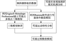
Fig. 3
Air-to-ground cooperative investigation flow chart"

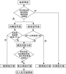
Fig. 4
Avalanche disaster zoning judgment flowchart"

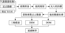
Fig. 5
Flow chart of UAV avalanche survey technique"

Tab. 1
Physical properties of snow"
| 雪型 | 内聚力/(g·cm-2) | 内摩擦系数 | 密度/(g·cm-3) | 抗断强度/(g·cm-2) |
|---|---|---|---|---|
| 新雪 | 5 | 0.22 | 0.15(实测) | 2.8 |

Fig. 6
Actual map of avalanche point location and accumulation area"

Tab. 2
Snow cover characteristics in accumulation area"
| 雪层厚度/cm | |||||||
|---|---|---|---|---|---|---|---|
| 100 | 80 | 60 | 40 | 20 | 10 | 0 | |
| 雪层温度/℃ | -0.1 | -0.6 | -0.4 | -0.1 | -0.1 | 0 | 0 |
| 雪层密度/(g·cm-3) | 263 | 283 | 303 | 314 | 337 | 360 | 385 |
Tab. 3
UAV tilt photography flight parameters"
| 项目 | 参数 | 项目 | 参数 |
|---|---|---|---|
| 模式 | 倾斜摄影 | 拍照模式 | 等距间隔拍照 |
| 航线/条 | 5 | 旁向重叠率/% | 75 |
| 倾斜角度/(°) | 45 | 航线重叠率/% | 80 |
| 飞行高度/m | 1000 | 旁向重叠率(倾斜)/% | 70 |
| 边距/m | 20 | 航线重叠率(倾斜)/% | 70 |
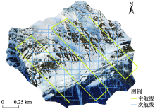
Fig.7
Study the regional route chart"

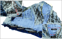
Fig. 8
3D real life model"

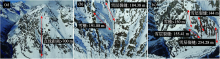
Fig. 9
Disaster interpretation results"

Tab. 4
The values of friction coefficients μ and ξ for different terrain and altitudes"
| 地形条件 | 海拔/m | μ | ξ |
|---|---|---|---|
| 非沟渠型地形 | >3000 | 0.29 | 1500 |
| 3000~2700 | 0.305 | 1400 | |
| <2700 | 0.33 | 1250 | |
| 沟渠型地形 | >3000 | 0.34 | 1250 |
| 3000~2700 | 0.355 | 1180 | |
| <2700 | 0.37 | 1050 | |
| 沟谷地形 | >3000 | 0.45 | 1050 |
| 3000~2700 | 0.46 | 1100 | |
| <2700 | 0.47 | 900 | |
| 平坦地形 | >3000 | 0.275 | 1750 |
| 3000~2700 | 0.285 | 1600 | |
| <2700 | 0.295 | 1500 |
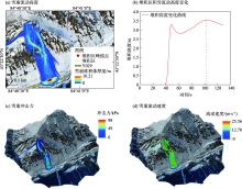
Fig. 10
Analysis of slope avalanche movement characteristics"


Fig. 11
Characterisation of trench-slope composite avalanche kinematic signature map"

Tab. 5
Statistics of simulation results at different fracture depths"
| 不同断裂深度/m | |||
|---|---|---|---|
| 0.84 | 0.67 | 0.34 | |
| 运动时长/s | 256 | 275 | 298 |
| 堆积量/m3 | 11717 | 4578.22 | 3107.76 |
| 堆积面积/m2 | 1369.7 | 1299.5 | 1178.5 |
| 堆积区最大流动高度/m | 9.22 | 7.03 | 4.23 |
| 最大堆积高度/m | 3.8 | 3.05 | 2.47 |
| 平均堆积深度/m | 2.5 | 2.27 | 1.64 |
| 堆积区最大流动速度/(m·s-1) | 13.6 | 10.24 | 6.58 |
| 堆积区最大冲击力/kPa | 30.72 | 21.42 | 17.97 |
| [1] |
王世金, 任贾文. 国内外雪崩灾害研究综述[J]. 地理科学进展, 2012, 31(11): 1529-1536.
doi: 10.11820/dlkxjz.2012.11.014 |
|
[Wang Shijin, Ren Jiawen. A review of the progresses of avalanche hazards research[J]. Progress in Geography, 2012, 31(11): 1529-1536.]
doi: 10.11820/dlkxjz.2012.11.014 |
|
| [2] |
Katja Laute, Achim A. Beylich. Morphometric and meteorological controls on recent snow avalanche distribution and activity at hillslopes in steep mountain valleys in western Norway[J]. Geomorphology, 2013, 218: 16-34.
doi: 10.1016/j.geomorph.2013.06.006 |
| [3] | 文谨, 陈思齐. 青藏高原及其周边地区的雪崩灾害及应对策略研究[J]. 今日科苑, 2021, 25(7): 83-89. |
| [Wen Jin, Chen Siqi. Research on the snow avalanche disasters over the Qinghai-Tibet Plateau and its surrounding areas and corresponding coping strategies[J]. Modern Science, 2021, 25(7): 83-89.] | |
| [4] | 杨金明, 张旭, 毛炜峄, 等. 中国天山雪崩灾害调查分析[J]. 自然灾害学报, 2022, 31(1): 188-197. |
| [Yang Jinming, Zhang Xu, Mao Weiyi, et al. Investigation and analysis of snow avalanche disaster in Tianshan Mountains of China[J]. Journal of Natural Disasters, 2022, 31(1): 188-197.] | |
| [5] |
Liu Yang, Chen Xi, Qiu Yubao, et al. Mapping snow avalanche debris by object-based classification in mountainous regions from Sentinel-1 images and causative indices[J]. Catena, 2021, 206: 105559.
doi: 10.1016/j.catena.2021.105559 |
| [6] |
郝建盛, 李兰海. 雪崩灾害防治研究进展及展望[J]. 冰川冻土, 2022, 44(3): 762-770.
doi: 10.7522/j.issn.1000-0240.2022.0075 |
|
[Hao Jiansheng, Li Lanhai. Progress and prospect of avalanche disaster prevention and control research[J]. Journal of Glaciology and Geocryology, 2022, 44(3): 762-770.]
doi: 10.7522/j.issn.1000-0240.2022.0075 |
|
| [7] | 李德仁, 李明. 无人机遥感系统的研究进展与应用前景[J]. 武汉大学学报(信息科学版), 2014, 39(5): 505-513, 540. |
| [Li Deren, Li Ming. Research advance and application prospect of Unmanned Aerial Vehicle remote sensing system[J]. Geomatics and Information Science of Wuhan University, 2014, 39(5): 505-513, 540.] | |
| [8] | 胡可, 陈思思, 王俊伟. 无人机载红外载荷在应急测绘中的应用[J]. 测绘科学, 2015, 40(10): 60-64. |
| [Hu Ke, Chen Sisi, Wang Junwei. The application of infrared UAV playload in emergency mapping support[J]. Science of Surveying and Mapping, 2015, 40(10): 60-64.] | |
| [9] | 鲁恒, 李永树, 李何超, 等. 无人机影像数字处理及在地震灾区重建中的应用[J]. 西南交通大学学报, 2010, 45(4): 533-538, 573. |
| [Lu Heng, Li Yongshu, Li Hechao, et al. Digital processing of unmanned aerial vehicle images and its application in reconstruction of Wenchuan earthquake-stricken areas[J]. Journal of Southwest Jiaotong University, 2010, 45(4): 533-538, 573.] | |
| [10] | 赵星涛, 胡奎, 卢晓攀, 等. 无人机低空航摄的矿山地质灾害精细探测方法[J]. 测绘科学, 2014, 39(6): 49-52, 64. |
| [Zhao Xingtao, Hu Kui, Lu Xiaopan, et al. Precise detection method for mine geological disasters using low-altitude photogrammetry based on unmanned aerial vehicle[J]. Science of Surveying and Mapping, 2014, 39(6): 49-52, 64.] | |
| [11] |
彭大雷, 许强, 董秀军, 等. 无人机低空摄影测量在黄土滑坡调查评估中的应用[J]. 地球科学进展, 2017, 32(3): 319-330.
doi: 10.11867/j.issn.1001-8166.2017.03.0319 |
|
[Peng Dalei, Xu Qiang, Dong Xiujun, et al. Application of unmanned aerial vehicles low-altitude photogrammetry in investigation and evaluation of loess landslide[J]. Advances in Earth Science, 2017, 32(3): 319-330.]
doi: 10.11867/j.issn.1001-8166.2017.03.0319 |
|
| [12] | Eirik Malnes, Markus Eckerstorfer, Yngvar Larsen, et al. Remote Sensing of Avalanches in Northern Norway Using Synthetic Aperture Radar[C]. International Snow Science Workshop Grenoble, 2013. |
| [13] |
Yang Jinming, He Qing, Liu Yang. Winter-spring prediction of snow avalanche susceptibility using optimisation multi-source heterogeneous factors in the Western Tianshan Mountains, China[J]. Remote Sensing, 2022, 14(6):1340.
doi: 10.3390/rs14061340 |
| [14] | Markus Eckerstorfer, Stian Solbo, Eirik Malnes. Using “Structure-from-Motion” photogrammetry in mapping snow avalanche debris[J]. Vienna, 2015, 21: 171-178. |
| [15] |
Gao Hongkai, He Xiaobo, Ye Baisheng, et al. Modeling the runoff and glacier mass balance in a small watershed on the Central Tibetan Plateau, China, from 1955 to 2008[J]. Hydrological Processes, 2012, 26(11): 1593-1603.
doi: 10.1002/hyp.v26.11 |
| [16] | Voellmy A. Über die Zerstörungskraft von Lawinen[J]. Sch-weizerische Bauzeitung, 1964, 73: 159-165. |
| [17] | Salm B, Burkhard A, Gubler H U. Berechnung von Fliess-lawinen: Eine anleitung fuer Praktiker; mit Beispielen[J]. Mitteilungen des Eidgenoessischen Instituts fuer Schnee-und Lawinenforschung, 1990, 47: 1-37. |
| [18] | 杨明军, 康冰锋, 韩丹. 基于LiDAR和倾斜摄影测量技术的实景三维自动化建模方法[J]. 科技资讯, 2018, 16(33): 93-96. |
| [Yang Mingjun, Kang Bingfeng, Han Dan. Automated modeling method for real-world 3D based on LiDAR and inclined photogrammetry[J]. Science and Technology Information, 2018, 16(33): 93-96.] | |
| [19] | 管建军, 王俊豪, 王双亭, 等. 无人机倾斜摄影在黄土地区泥石流灾害调查与评价中的应用[J]. 中国地质灾害与防治学报, 2017, 28(4): 137-145. |
| [Guan Jianjun, Wang Junhao, Wang Shuangting, et al. Application of UAV oblique photography in investigation and evaluation of debris flow disasters in loess area[J]. The Chinese Journal of Geological Hazards and Control, 2017, 28(4): 137-145.] | |
| [20] | 闫烨琛, 高学飞, 于向吉, 等. 无人机倾斜摄影测量技术在地质灾害隐患调查中的应用研究[J]. 科技创新与应用, 2022, 12(17): 193-196. |
| [Yan Yechen, Gao Xuefei, Yu Xiangji, et al. Research on the application of UAV inclined photogrammetry technology in the investigation of geologic hazards[J]. Technology Innovation and Application, 2022, 12(17): 193-196.] | |
| [21] | 王靖文, 唐志光, 邓刚, 等. 1991—2021年天山融雪末期雪线高度遥感监测研究[J]. 干旱区研究, 2022, 39(5): 1385-1397. |
| [Wang Jinwen, Tang Zhiguang, Deng Gang, et al. Monitoring of snowline altitude at the end of melting season in Tianshan Mountains from 1991 to 2021[J]. Arid Zone Research, 2022, 39(5): 1385-1397.] | |
| [22] | 苗运玲, 于永波, 霍达, 等. 中天山北坡冬季降雪变化及其影响因子分析[J]. 干旱区研究, 2023, 40(1): 9-18. |
| [Miao Yunling, Yu Yongbo, Huo Da, et al. Analysis of winter snowfall variability and its influencing factors on thenorth slopes of the middle Tianshan Mountains[J]. Arid Zone Research, 2023, 40(1): 9-18.] | |
| [23] | 汶林科, 向灵芝, 蔡毅, 等. 雪崩的形成机理研究[J]. 山地学报, 2016, 34(1): 1-11. |
| [Wen Linke, Xiang Lingzhi, Cai Yi, et al. Research on the formation mechanism of avalanche[J]. Mountain Research, 2016, 34(1): 1-11.] | |
| [24] |
Schweizer J, Jamieson J B. Snow cover properties for skier triggering of avalanches[J]. Cold Regions Science and Technology, 2001, 33(2-3): 207-221.
doi: 10.1016/S0165-232X(01)00039-8 |
| [25] | 王彦龙. 我国的干雪雪崩[J]. 冰川冻土, 1986, 8(4): 381-387. |
| [Wang Yanlong. Dry-snow avalanches in China[J]. Journal of Glaciology and Geocryology, 1986, 8(4): 381-387.] | |
| [26] | 郭玲鹏, 李兰海, 徐俊荣, 等. 气温变化条件下融雪速率和土壤水分变化的同步观测试验[J]. 干旱区研究, 2012, 29(5): 890-897. |
| [Guo Lingpeng, Li Lanhai, Xu Junrong, et al. Experimental study on simultaneous observation of snowmelt and soil moisture content under air temperature increase[J]. Arid Zone Research, 2012, 29(5): 890-897.] | |
| [27] | Ahmet Şasi, Murat Yakar. Photogrammetry modelling of sekihan masjid using an unmanned aerial vehicle[J]. Turkish Journal of Engineering, 2017, 1(2): 39-44. |
| [28] | 何敬, 李永树, 鲁恒, 等. 无人机影像的质量评定及几何处理研究[J]. 测绘通报, 2010, 56(4): 22-24, 35. |
| [He Jing, Li Yongshu, Lu Heng, et al. Research of UAV image quality evaluation and geometry processing[J]. Bulletin of Surveying and Mapping, 2010, 56(4): 22-24, 35.] | |
| [29] |
Cao Duanguang, Zhang Baolei, Zhang Xiaobo, et al. Optimization methods on dynamic monitoring of mineral reserves for open pit mine based on UAV oblique photogrammetry[J]. Measurement, 2023, 207: 112364.
doi: 10.1016/j.measurement.2022.112364 |
| [30] | 桂德竹, 林宗坚, 张成成. 倾斜航空影像的城市建筑物三维模型构建研究[J]. 测绘科学, 2012, 37(4): 140-142. |
| [Gui Dezhu, Lin Zongjian, Zhang Chengcheng. Research on construction of 3D building based on oblique images from UAV[J]. Science of Surveying and Mapping, 2012, 37(4): 140-142.] | |
| [31] |
Marco Martini, Tommaso Baggio, Vincenzo D'Agostino. Comparison of two 2-D numerical models for snow avalanche simulation[J]. Science of the Total Environment, 2023, 896: 165221.
doi: 10.1016/j.scitotenv.2023.165221 |
| [32] | Christen M, Kowalski J, Bartelt P. RAMMS: Numerical simulation of dense snow avalanches in three-dimensional terrain[J]. Cold Regions Science & Technology, 2010, 63(1-2): 1-14. |
| [33] | 胡汝骥, 马维林, 王存牛. 中国天山的雪崩及其治理[J]. 冰川冻土, 1987, 9(S1): 13-24, 150. |
| [Hu Ruji, Ma Weilin, Wang Cunniu. Avalanches in Tianshan Mountains, China, and their control[J]. Journal of Glaciology and Geocryology, 1987, 9(S1): 13-24, 150.] | |
| [34] | 胡汝骥, 迟国彬, 马维林, 等. 天山西部雪崩防治的研究[J]. 干旱区地理, 1981, 5(1): 39-46. |
| [Hu Ruji, Chi Guobin, Ma Weilin, et al. Research on avalanche control in the western Tianshan Mountains[J]. Arid Land Geography, 1981, 5(1): 39-46.] | |
| [35] | 胡汝骥, 马维林, 魏文寿, 等. 我国天山降雪与季节性雪崩的基本物理特征[J]. 干旱区地理, 1985, 8(1): 57-61. |
| [Hu Ruji, Ma Weilin, Wei Wenshou, et al. Basic physical characteristics of snowfall and seasonal avalanches in the Tianshan Mountains of China[J]. Arid Land Geography, 1985, 8(1): 57-61.] | |
| [36] | 邱隆君. 基于数字高程模型的重力中区地形改正[J]. 地质论评, 2023, 69(S1): 395-396. |
| [Qiu Longjun. Gravity exploration medium-zone terrain correction based on digital elevation model[J]. Geological Review, 2023, 69(S1): 395-396.] | |
| [37] | 张宏鸣, 樊世豪, 陈茹雪, 等. 基于数字高程模型的淤地坝地区河网提取方法[J]. 农业机械学报 2023, 54(9): 246-253, 269. |
| [Zhang Hongming, Fan Shihao, Chen Ruxue, et al. Research on channel network extraction method in check dam area based on DEM[J]. Transactions of the Chinese Society for Agricultural Machinery, 2023, 54(9): 246-253, 269.] | |
| [38] |
Christen Marc, Bartelt Perry, Kowalski Julia. Back calculation of the in den Arelen avalanche with RAMMS: Interpretation of model results[J]. Annals of Glaciology, 2010, 51(54): 161-168.
doi: 10.3189/172756410791386553 |
| [39] |
Buhler Y, Christen M, Kowalski J, et al. Sensitivity of snow avalanche simulations to digital elevation model quality and resolution[J]. Annals of Glaciology, 2011, 52(58): 72-80.
doi: 10.3189/172756411797252121 |
| [40] |
Jamieson Bruce, Johnston Colin D. Snowpack factors associated with strength changes of buried surface hoar layers[J]. Cold Regions Science and Technology, 1999, 30(1-3): 19-34.
doi: 10.1016/S0165-232X(99)00026-9 |
| [41] |
王建, 车涛, 李震, 等. 中国积雪特性及分布调查[J]. 地球科学进展, 2018, 33(1): 12-26.
doi: 10.11867/j.issn.1001-8166.2018.01.0012 |
|
[Wang Jian, Che Tao, Li Zhen, et al. Investigation on snow characteristics and their distribution in China[J]. Advances in Earth Science, 2018, 33(1): 12-26.]
doi: 10.11867/j.issn.1001-8166.2018.01.0012 |
|
| [42] | 张志忠. 天山巩乃斯河谷公路雪崩防治研究的初步结果[J]. 冰川冻土, 1981, 3(4): 65-71, 120. |
| [Zhang Zhizhong. Preliminary results of avalanche prevention and control studies on highways in Kunes Valley, Tianshan Mountains[J]. Journal of Glaciology and Geocryology, 1981, 3(4): 65-71, 120.] |
|
||