Arid Zone Research ›› 2023, Vol. 40 ›› Issue (9): 1509-1516.doi: 10.13866/j.azr.2023.09.14
• Ecology and Environment • Previous Articles Next Articles
SUN Maosen1( ),WANG Ranghui1(),NING Husen2
Received:2023-04-01
Revised:2023-06-01
Online:2023-09-15
Published:2023-09-28
Contact:
Ranghui WANG
E-mail:20211207002@nuist.edu.cn;rhwang@nuist.edu.cn
SUN Maosen,WANG Ranghui,NING Husen. Construction of the ecological network in the Aksu River Basin[J].Arid Zone Research, 2023, 40(9): 1509-1516.
Add to citation manager EndNote|Reference Manager|ProCite|BibTeX|RefWorks
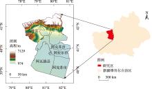
Fig. 1
Location of study area"

Tab. 1
Change of ecological source and important ecological corridors in Aksu River Basin"
| 年份 | 核心区面积占比/% | 重要生态源地数/个 | 重要生态源地面积占流域总面积比例/% | 重要生态廊道/条 |
|---|---|---|---|---|
| 1980 | 6.48 | 7 | 2.76 | 9 |
| 1990 | 6.46 | 7 | 2.77 | 9 |
| 2000 | 9.27 | 6 | 5.37 | 7 |
| 2010 | 10.82 | 9 | 7.52 | 16 |
| 2020 | 12.47 | 10 | 9.06 | 17 |
Tab. 2
Resistance value and weight"
| 阻力因子 | 权重 | 阻力等级 | ||||
|---|---|---|---|---|---|---|
| 1 | 2 | 3 | 4 | 5 | ||
| 土地利用类型 | 0.27 | 林地、耕地和中、 高覆盖度草地 | 低覆盖度草地、 水体 | 盐碱地、 沼泽地 | 其他未利用 土地 | 城乡、工矿、 居民用地 |
| 距水体距离/km | 0.13 | ≤0.1 | (0.1,0.5] | (0.5,1.0] | (1.0,1.5] | >1.5 |
| 距城镇距离/km | 0.15 | >2.5 | (2.0,2.5] | (1.5,2.0] | (1.0,1.5] | ≤1.0 |
| 距农村居民点距离/km | 0.11 | >2.0 | (1.5,2.0] | (1.0,1.5] | (0.5,1.0] | ≤0.5 |
| 距工业点距离/km | 0.17 | >3.5 | (3.0,3.5] | (2.5,3.0] | (2.0,2.5] | ≤2.0 |
| 坡度/(°) | 0.08 | ≤5 | (5,12] | (12,21] | (21,30] | >30 |
| 海拔/km | 0.09 | ≤1.4 | (1.4,2.1] | (2.1,3.0] | (3.0,4.1] | >4.1 |
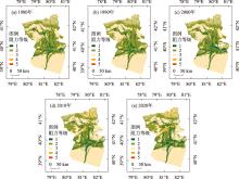
Fig. 2
Spatial distribution of ecological resistance levels in Aksu River Basin"

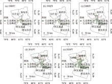
Fig. 3
Spatial distribution of ecological network in Aksu River Basin"

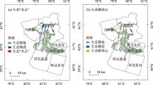
Fig. 4
The current intensity of ecological pinch points and ecological barrier points in Aksu River Basin"

| [1] | 许丽婷, 刘海红, 黄丽洁, 等. 2000—2020年汾河流域生态环境与水源涵养时空变化[J]. 干旱区研究, 2023, 40(2): 313-325. |
| [Xu Liting, Liu Haihong, Huang Lijie, et al. Spatial and temporal changes of ecological environment and water conservation in Fenhe River Basin from 2000 to 2020[J]. Arid Zone Research, 2023, 40(2): 313-325.] | |
| [2] |
Huang Jianping, Yu Haipeng, Dai Aiguo, et al. Drylands face potential threat under 2 °C global warming target[J]. Nature Climate Change, 2017, 7: 417-422.
doi: 10.1038/NCLIMATE3275 |
| [3] | 王让会, 张卫东, 周丽敏, 等. 气候变化及景观格局与生态安全的耦合关系[J]. 南京信息工程大学学报(自然科学版), 2022, 14(5): 509-515. |
| [Wang Ranghui, Zhang Weidong, Zhou Limin. Coupling relationship between climate change, landscape pattern and ecological security[J]. Journal of Nanjing University of Information Science & Technology (Natural Science Edition), 2022, 14(5): 509-515.] | |
| [4] | 金爱博, 张诗阳, 王向荣. 宁绍平原绿地生态网络时空格局与优化研究[J]. 生态与农村环境学报, 2022, 38(11): 1415-1426. |
| [Jin Aibo, Zhang Shiyang, Wang Xiangrong. Spatial-temporal pattern and optimization of the green space ecological networks in the Ningshao Plain[J]. Journal of Ecology and Rural Environment, 2022, 38(11): 1415-1426.] | |
| [5] |
Dindaroglu T. Determination of ecological networks for vegetation connectivity using GIS & AHP technique in the Mediterranean degraded karst ecosystems[J]. Journal of Arid Environments, 2021, 188: 104385.
doi: 10.1016/j.jaridenv.2020.104385 |
| [6] |
Wu Zhenhua, Lei Shaogang, Yan Qingwu, et al. Landscape ecological network construction controlling surface coal mining effect on landscape ecology: A case study of a mining city in semi-arid steppe[J]. Ecological Indicators, 2021, 133: 108403.
doi: 10.1016/j.ecolind.2021.108403 |
| [7] | 荣月静, 严岩, 王辰星, 等. 基于生态系统服务供需的雄安新区生态网络构建与优化[J]. 生态学报, 2020, 40(20): 7197-7206. |
| [Rong Yuejing, Yan Yan, Wang Chenxing, et al. Construction and optimization of ecological network in Xiong’an New Area based on the supply and demand of ecosystem services[J]. Acta Ecologica Sinica, 2020, 40(20): 7197-7206.] | |
| [8] |
Miao Zuohua, Pan Lei, Wang Qiaozhi, et al. Research on urban ecological network under the threat of road networks—A case study of Wuhan[J]. ISPRS International Journal of Geo-Information, 2019, 8(8): 342.
doi: 10.3390/ijgi8080342 |
| [9] |
Shi Fangning, Liu Shiliang, Sun Yongxiu, et al. Ecological network construction of the heterogeneous agro-pastoral areas in the upper Yellow River basin[J]. Agriculture, Ecosystems & Environment, 2020, 302(38): 107069.
doi: 10.1016/j.agee.2020.107069 |
| [10] |
Tarabon S, Calvet C, Delbar V, et al. Integrating a landscape connectivity approach into mitigation hierarchy planning by anticipating urban dynamics[J]. Landscape and Urban Planning, 2020, 202: 103871.
doi: 10.1016/j.landurbplan.2020.103871 |
| [11] |
Almeida M R, Andrello M, Pressey R L, et al. Biologically representative and well-connected marine reserves enhance biodiversity persistence in conservation planning[J]. Conservation Letters, 2018, 11(4): e12439.
doi: 10.1111/conl.2018.11.issue-4 |
| [12] |
Dong Jianquan, Peng Jian, Xu Zihan. Integrating regional and interregional approaches to identify ecological security patterns[J]. Landscape Ecology, 2021, 36: 2151-2164.
doi: 10.1007/s10980-021-01233-7 |
| [13] | 吴茂全, 胡蒙蒙, 汪涛, 等. 基于生态安全格局与多尺度景观连通性的城市生态源地识别[J]. 生态学报, 2019, 39(13): 4720-4731. |
| [Wu Maoquan, Hu Mengmeng, Wang Tao, et al. Recognition of urban ecological source area based on ecological security pattern and multi-scale landscape connectivity[J]. Acta Ecologica Sinica, 2019, 39(13): 4720-4731.] | |
| [14] | Regan R S, Juracek K E, Hay L E, et al. The U. S. Geological Survey National Hydrologic Model infrastructure: Rationale, description, and application of a watershed-scale model for the conterminous United States[J]. Environmental Modelling & Software, 2019, 111: 192-203. |
| [15] |
Zhu Liangjun, Qin Chengzhi, Zhu Axing. Spatial optimization of watershed best management practice scenarios based on boundary-adaptive configuration units[J]. Progress in Physical Geography: Earth and Environment, 2021, 45(2): 207-227.
doi: 10.1177/0309133320939002 |
| [16] |
Xu Chen, Yang Guishan, Wan Rongrong, et al. Toward ecological function zoning and comparison to the Ecological Redline Policy: A case study in the Poyang Lake Region, China[J]. Environmental Science and Pollution Research, 2021, 28: 40178-40191.
doi: 10.1007/s11356-020-12225-6 |
| [17] |
Peng Jian, Pan Yajing, Liu Yanxu, et al. Linking ecological degradation risk to identify ecological security patterns in a rapidly urbanizing landscape[J]. Habitat International, 2018, 71: 110-124.
doi: 10.1016/j.habitatint.2017.11.010 |
| [18] |
Pierre S, Peter V. Morphological segmentation of binary patterns[J]. Pattern Recognition Letters, 2009, 30(4): 456-459.
doi: 10.1016/j.patrec.2008.10.015 |
| [19] | 陈竹安, 马彬彬, 危小建, 等. 基于MSPA和MCR模型的南昌市生态网络构建与优化[J]. 水土保持通报, 2021, 41(6): 139-147. |
| [Chen Zhu’an, Ma Binbin, Wei Xiaojian. Construction and optimization of ecological network of Nanchang City based on MSPA and MCR model[J]. Bulletin of Soil and Water Conservation, 2021, 41(6): 139-147.] | |
| [20] | 付凤杰, 刘珍环, 刘海. 基于生态安全格局的国土空间生态修复关键区域识别——以贺州市为例[J]. 生态学报, 2021, 41(9): 3406-3414. |
| [Fu Fengjie, Liu Zhenhuai, Liu Hai. Identifying key areas of ecosystem restoration for territorial space based on ecological security pattern: A case study in Hezhou City[J]. Acta Ecologica Sinica, 2021, 41(9): 3406-3414.] | |
| [21] | 徐新良, 刘纪远, 张树文, 等. 中国多时期土地利用遥感监测数据集(CNLUCC)[DB/OL].http://www.resdc.cn. [2023-3-25]. |
| [Xu Xinliang, Liu Jiyuan, Zhang Shuwen, et al. Multi-period land use and land cover remote sensing monitoring data set in China[DB/OL]. http://www.resdc.cn. [2023-3-25].] | |
| [22] |
James D W, Kurt H R, Timothy G W, et al. A national assessment of green infrastructure and change for the conterminous United States using morphological image processing[J]. Landscape and Urban Planning, 2010, 94(3/4): 186-195.
doi: 10.1016/j.landurbplan.2009.10.003 |
| [23] |
Zhang Yali, Shen Wenjuan, Li Mingshi, et al. Assessing spatio-temporal changes in forest cover and fragmentation under urban expansion in Nanjing, eastern China, from long-term Landsat observations (1987-2017)[J]. Applied Geography, 2020, 117: 102190.
doi: 10.1016/j.apgeog.2020.102190 |
| [24] | 吴金华, 刘思雨, 白帅. 基于景观生态安全的神木市生态廊道识别与优化[J]. 干旱区研究, 2021, 38(4): 1120-1127. |
| [Wu Jinhua, Liu Siyu, Bai Shuai. Identification and optimization of ecological corridors in Shenmu City based on landscape ecological security[J]. Arid Zone Research, 2021, 38(4): 1120-1127.] | |
| [25] |
Mcrae B H, Dickson B G, Keitt T H, et al. Using circuit theory to model connectivity in ecology, evolution, and conservation[J]. Ecology, 2008, 89(10): 2712-2724.
doi: 10.1890/07-1861.1 pmid: 18959309 |
|
||