干旱区研究 ›› 2024, Vol. 41 ›› Issue (9): 1560-1571.doi: 10.13866/j.azr.2024.09.12 cstr: 32277.14.AZR.20240912
陈松清( ), 东红芳, 岳怡锋, 郝媛媛(), 刘新, 曹先宇, 马骏
收稿日期:2023-09-07
修回日期:2023-11-29
出版日期:2024-09-15
发布日期:2024-09-25
通讯作者:
郝媛媛. E-mail: haoyy@gsau.edu.cn作者简介:陈松清(2000-),男,硕士研究生,主要从事草地生态研究. E-mail: 17352091400@163.com
基金资助:
CHEN Songqing(), DONG Hongfang, YUE Yifeng, HAO Yuanyuan(), LIU Xin, CAO Xianyu, MA Jun
Received:2023-09-07
Revised:2023-11-29
Published:2024-09-15
Online:2024-09-25
摘要:
探究影响中国沙棘分布的主导环境因子,模拟其潜在适生区,以期为中国沙棘的种植、资源保护和开发利用提供理论依据。采用接收者操作特征曲线及其曲线下面积评估MaxEnt模型精度,综合贡献率、置换重要值及刀切法筛选中国沙棘主导环境因子并判定其适生范围,应用MaxEnt模型模拟并预测中国沙棘当前及未来气候条件下的适生区及其动态变化。结果表明:(1) 模型精度较高(平均训练AUC=0.953),能够有效模拟中国沙棘的潜在分布。(2) 年降水量(325~650 mm)、海拔(1200~3850 m)、最冷季度平均温度(-7.25~1.25 ℃)、最干月份降水量(1~4 mm)是影响中国沙棘分布的主导环境因子。(3) 中国沙棘主要集中分布在甘肃、青海、四川、西藏、宁夏、陕西、山西、河南、河北及内蒙古地区,云南和贵州等地也有零星分布;未来气候改变,不仅迫使中国沙棘向西北方向高纬度、高海拔地区以及云贵高原地区扩张,而且使得东南方向低纬度、低海拔分布区明显收缩,但整体分布面积增大。海拔和水热条件是影响中国沙棘分布的主导因素,未来为应对气候变化,应将沙棘产业重心向西北中高海拔地区偏移,并对中国沙棘资源进行合理开发及利用,以实现该资源的可持续发展。
陈松清, 东红芳, 岳怡锋, 郝媛媛, 刘新, 曹先宇, 马骏. 不同气候情景下中国沙棘的地理分布及动态变化预测[J]. 干旱区研究, 2024, 41(9): 1560-1571.
CHEN Songqing, DONG Hongfang, YUE Yifeng, HAO Yuanyuan, LIU Xin, CAO Xianyu, MA Jun. Geographical distribution and dynamic change prediction of Hippophae rhamnoides subsp. sinensis under different climate scenarios[J]. Arid Zone Research, 2024, 41(9): 1560-1571.
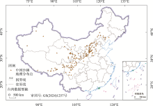
图1
中国沙棘种群分布点地理位置"

表1
环境因子指标及其详细信息"
| 具体指标 | 环境因子 | 时间序列 | 数据来源 |
|---|---|---|---|
| 气候 | Bio1(年平均气温) | 世界气候 数据库 (Worldclim) | |
| Bio2(平均气温日较差) | |||
| Bio3(等温性) | |||
| Bio4(气温季节性变动系数) | |||
| Bio5(最热月份最高温度) | |||
| Bio6(最冷月份最低温度) | |||
| Bio7(气温年较差) | |||
| Bio8(最湿季度平均温度) | 当前(1970— 2000年) | ||
| Bio9(最干季度平均温度) | 未来(2021— 2040年) | ||
| Bio10(最暖季度平均温度) | 未来(2041— 2060年) | ||
| Bio11(最冷季度平均温度) | |||
| Bio12(年降水量) | |||
| Bio13(最湿月份降水量) | |||
| Bio14(最干月份降水量) | |||
| Bio15(降水量季节性变化) | |||
| Bio16(最干季度降水量) | |||
| Bio17(最湿季度降水量) | |||
| Bio18(最暖季度降水量) | |||
| Bio19(最冷季度降水量) | |||
| 地形 | Elevation(海拔) | 当前(1970— 2000年) | 世界气候 数据库 (Worldclim) |
| Slope(坡度) | |||
| Aspect(坡向) | |||
| 土壤 | Soil-type(土壤质地类型) | 当前(1971— 1981年) | 联合国粮农 组织数据库 (FaoStat) |
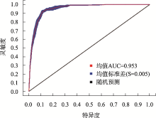
图2
中国沙棘预测结果ROC检验"

表2
各环境变量对中国沙棘分布的重要性分析"
| 环境变量 | 描述 | 贡献率/% | 置换重要值/% |
|---|---|---|---|
| Bio12 | 年降水量/mm | 25.4 | 29.6 |
| Elevation | 海拔/m | 24.7 | 18.3 |
| Bio11 | 最冷季度平均温度/℃ | 22.4 | 12.3 |
| Bio14 | 最干月份降水量/mm | 17.0 | 19.2 |
| Bio4 | 气温季节性变动系数 | 2.8 | 9.2 |
| Aspect | 坡向/(°) | 2.7 | 1.5 |
| Bio2 | 平均气温日较差/℃ | 2.4 | 6.2 |
| Slope | 坡度/(°) | 1.7 | 2.2 |
| Bio15 | 降水量季节性变化/mm | 0.9 | 1.5 |
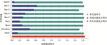
图3
各环境因子对中国沙棘潜在分布模型的Jacknife检验得分 注:图中环境变量含义见表1。"

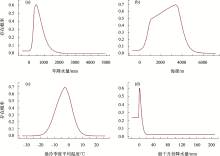
图4
中国沙棘主导环境因子响应曲线"

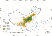
图5
当前气候情景下中国沙棘潜在适生区"

表3
潜在适宜分布区面积统计"
| 适生等级 | 预测值 | 分布面积/104 km2 |
|---|---|---|
| 高适生区 | 0.48~1.0 | 41.9 |
| 中适生区 | 0.25~0.48 | 53.6 |
| 低适生区 | 0.08~0.25 | 92.6 |
| 非适生区 | 0.00~0.08 | 770.8 |
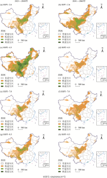
图6
未来气候情景下中国沙棘潜在适生区"

表4
未来4种不同情景下中国沙棘适生区面积变化"
| 适生区 面积变化/% | SSP1-2.6 | SSP2-4.5 | SSP3-7.0 | SSP5-8.5 | |||||||
|---|---|---|---|---|---|---|---|---|---|---|---|
| 2021—2040年 | 2041—2060年 | 2021—2040年 | 2041—2060年 | 2021—2040年 | 2041—2060年 | 2021—2040年 | 2041—2060年 | ||||
| 低适生区 | 97.1 | 197.2 | 198.8 | 57.3 | 62.4 | 167.0 | 126.7 | 50.2 | |||
| 中适生区 | 10.1 | 79.8 | 248.7 | -84.4 | -47.5 | -77.7 | -21.9 | -68.8 | |||
| 高适生区 | -98.7 | -98.0 | 14.3 | -100.0 | -99.8 | -100.0 | -99.3 | -99.9 | |||
| 总适生区 | 28.7 | 97.9 | 171.9 | -18.1 | -5.1 | 37.7 | 34.0 | -9.8 | |||
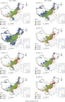
图7
未来气候情景下中国沙棘潜在适生区动态变化"

| [1] |
刘泽淼, 黄贤金, 卢学鹤, 等. 共享社会经济路径下中国碳中和路径预测[J]. 地理学报, 2022, 77(9): 2189-2201.
doi: 10.11821/dlxb202209004 |
|
[Liu Zemiao, Huang Xianjin, Lu Xuehe, et al. China’s carbon neutrality path prediction under the shared social economic paths[J]. Acta Geographica Sinica, 2022, 77(9): 2189-2201.]
doi: 10.11821/dlxb202209004 |
|
| [2] | 曹策, 蒋昕. 植物分布对气候变化的响应[J]. 绿色科技, 2017(16): 111-113. |
| [Cao Ce, Jiang Xin. Response of plant distribution to climate change[J]. Journal of Green Science and Technology, 2017(16): 111-113.] | |
| [3] | 陈禹锦, 罗喻才, 于芬, 等. 气候变化情景下毛竹潜在分布及动态预测[J]. 世界竹藤通讯, 2021, 19(3): 5-14. |
| [Chen Yujin, Luo Yucai, Yu Fen, et al. Potential distribution and dynamic prediction of Phyllostachys edulis under the scenarios of climate change[J]. World Bamboo and Rattan, 2021, 19(3): 5-14.] | |
| [4] | 麻雯迪, 李世宗. MaxEnt模型国内外研究进展及其在不同气候背景与区域尺度下的应用[J]. 林业建设, 2023(2): 32-40. |
| [Ma Wendi, Li Shizong. Development of maximum entropy model at home and abroad and its applications in different climatic backgrounds and regional scales[J]. Forestry Construction, 2023(2): 32-40.] | |
| [5] |
赵艳芬, 潘伯荣. 气候变化情景下革苞菊属在中国的潜在地理分布[J]. 干旱区研究, 2023, 40(6): 949-957.
doi: 10.13866/j.azr.2023.06.10 |
|
[Zhao Yanfen, Pan Borong. Potential geographical distributions of Tugarinovia in China under climate change scenarios[J]. Arid Zone Research, 2023, 40(6): 949-957.]
doi: 10.13866/j.azr.2023.06.10 |
|
| [6] | 李响, 张成福, 贺帅, 等. MaxEnt模型综合应用研究进展分析[J]. 绿色科技, 2020(14): 14-17. |
| [Li Xiang, Zhang Chengfu, He Shuai, et al. Research progress analysis on the comprehensive application of MaxEnt model[J]. Journal of Green Science and Technology, 2020(14): 14-17.] | |
| [7] | 高佩, 马亚琼, 何永超, 等. 中国沙棘根际固氮菌的分离、鉴定及促生能力比较[J]. 福建农林大学学报(自然科学版), 2024, 53(4): 522-531. |
| [Gao Pei, Ma Yaqiong, He Yongchao, et al. Isolation, identification and growth-promoting ability of azotobacter in rhizosphere of Hippophae rhamnoides subsp. sinensis Rousi[J]. Journal of Fujian Agriculture and Forestry University (Natural Science Edition), 2024, 53(4): 522-531.] | |
| [8] | 廉永善, 陈学林. 沙棘属植物的系统分类[J]. 沙棘, 1996, 9(1): 15-24. |
| [Lian Yongshan, Chen Xuelin. Systematic classification of Hippophae rhamnoides[J]. Seabuckthorn Hippophae, 1996, 9(1): 15-24.] | |
| [9] | 苏锦松, 赵彩云, 文检, 等. 中国沙棘叶黄酮类成分与生态因子相关性及其生态适宜性研究[J]. 中国中药杂志, 2017, 42(10): 1865-1870. |
|
[Su Jinsong, Zhao Caiyun, Wen Jian, et al. Correlation between flavonoids contents in Hippophae rhamnoides subsp. sinensis leaf and ecological factors, and ecological suitability analysis of H. rhamnoides subsp. sinensis[J]. China Journal of Chinese Materia Medica, 2017, 42(10): 1865-1870.]
doi: 10.19540/j.cnki.cjcmm.2017.0078 pmid: 29090544 |
|
| [10] | 陈学林, 廉永善. 沙棘属植物的分布格局及其成因[J]. 沙棘, 2007, 20(4): 1-5. |
| [Chen Xuelin, Lian Yongshan. Distribution patterns of Hippophae rhamnoides plants and their genesis[J]. Seabuckthorn Hippophae, 2007, 20(4): 1-5.] | |
| [11] | 胡晓霞, 吉小敏, 梁康贤, 等. 沙棘产业与新疆区域经济的增长[J]. 干旱区研究, 2006, 23(1): 71-75. |
| [Hu Xiaoxia, Ji Xiaomin, Liang Kangxian, et al. Industry of Hippophatae rhamnoides and the regional economic increase in Xinjiang[J]. Arid Zone Research, 2006, 23(1): 71-75.] | |
| [12] | 陈奕璇, 郭佳琦, 关文强, 等. 沙棘综合开发利用研究进展[J]. 食品研究与开发, 2023, 44(19): 201-207. |
| [Chen Yixuan, Guo Jiaqi, Guan Wenqiang, et al. Research progress on comprehensive development and utilization of Sea Buckthorn[J]. Food Research and Development, 2023, 44(19): 201-207.] | |
| [13] | 王举位, 张征, 安宝利, 等. 砒砂岩区沙棘林生态服务功能价值评估[J]. 干旱区资源与环境, 2012, 26(6): 198-204. |
| [Wang Juwei, Zhang Zheng, An Baoli, et al. Evaluation of Seabuckthorn forest ecosystem services value in soft rock region[J]. Journal of Arid Land Resources and Environment, 2012, 26(6): 198-204.] | |
| [14] | 张耀, 张成榆, 王彦裕, 等. 沙棘的克隆生长及其生态经济意义[J]. 国际沙棘研究与开发, 2009, 7(2): 24-30. |
| [Zhang Yao, Zhang Chengyu, Wang Yanyu, et al. Ecological and economic significance of clonal growth of Seabuckthorn[J]. Water Resources Development and Management, 2009, 7(2): 24-30.] | |
| [15] | 吴立仁. 黑龙江省沙棘发展概况及对策[J]. 北方园艺, 2010(16): 205-207. |
| [Wu Liren. Development general situation and countermeasure of Sea Buckthorn in Heilongjiang Province[J]. Northern Horticulture, 2010(16): 205-207.] | |
| [16] |
张林, 张云玲, 马松梅, 等. 准噶尔盆地大赖草分布格局及关键因子分析[J]. 干旱区研究, 2022, 39(3): 863-871.
doi: 10.13866/j.azr.2022.03.19 |
| [Zhang Lin, Zhang Yunling, Ma Songmei, et al. Distribution pattern and driving mechanisms of the sand plant Leymus racemosus in the Junggar Basin[J]. Arid Zone Research, 2022, 39(3): 863-871.] | |
| [17] | 张华纬, 赵健, 李志鹏. 基于GIS的入侵生物适生区预测——以桔小实蝇为例[J]. 测绘与空间地理信息, 2021, 44(6): 59-64. |
| [Zhang Huawei, Zhao Jian, Li Zhipeng. Prediction of suitable establishment areas of invasive species based on GIS: Take Bactrocera dorsalis (Hendel) as an example[J]. Geomatics & Spatial Information Technology, 2021, 44(6): 59-64.] | |
| [18] | 黄铨. 中国沙棘的地理变异[J]. 沙棘, 2003, 16(1): 8-13. |
| [Huang Quan. Geographical variation of Hippophae rhamnoides subsp. sinensis in China[J]. Seabuckthorn Hippophae, 2003, 16(1): 8-13.] | |
| [19] | 强大宏, 艾宁, 刘长海, 等. 煤矿复垦区沙棘人工林土壤水分时空分布特征研究[J]. 灌溉排水学报, 2019, 38(9): 82-87. |
| [Qiang Dahong, Ai Ning, Liu Changhai, et al. Temporal and spatial distribution characteristics of soil moisture in Seabuckthorn plantations in coal mine reclamation area[J]. Journal of Irrigation and Drainage, 2019, 38(9): 82-87.] | |
| [20] | 李玲, 李森, 邓东周, 等. 岷江上游中国沙棘土壤碳氮磷对海拔的响应及其计量特征[J]. 西南农业学报, 2019, 32(5): 1098-1103. |
| [Li Ling, Li Sen, Deng Dongzhou, et al. Effect of Elevation on soil nutrient content and stoichiometric characteristics under Hippophae rhamnoides L. shrubs in upper Min River[J]. Southwest China Journal of Agricultural Sciences, 2019, 32(5): 1098-1103.] | |
| [21] | 张丽霞, 陈晓龙, 辛晓歌. CMIP6情景模式比较计划(ScenarioMIP)概况与评述[J]. 气候变化研究进展, 2019, 15(5): 519-525. |
| [Zhang Lixia, Chen Xiaolong, Xin Xiaoge. Short commentary on CMIP6 scenario model intercomparison project (ScenarioMIP)[J]. Climate Change Research, 2019, 15(5): 519-525.] | |
| [22] | 吴统文, 宋连春, 李伟平, 等. 北京气候中心气候系统模式研发进展——在气候变化研究中的应用[J]. 气象学报, 2014, 72(1): 12-29. |
| [Wu Tongwen, Song Lianchun, Li Weiping, et al. An overview on progress in Beijing climate center climate system model—Its development and application to climate change studies[J]. Acta Meteorologica Sinica, 2014, 72(1): 12-29.] | |
| [23] | 秦委, 张虹, 杨明霞, 等. 基于MaxEnt模型和ArcGIS的东南茜草潜在分布研究[J]. 中国中医药信息杂志, 2022, 29(5): 1-4. |
| [Qin Wei, Zhang Hong, Yang Mingxia, et al. Study on potential distribution of Rubia argyi (Levl. et Van. ) Hara ex L. A. Lauener et D. K. based on MaxEnt model and ArcGIS[J]. China Journal of Information on Traditional Chinese Medicine, 2022, 29(5): 1-4.] | |
| [24] | 景志贤, 李梦, 张小波, 等. 基于全球气候数据和MaxEnt模型的辣木全球气候适宜区研究[J]. 中国现代中药, 2021, 23(8): 1352-1356. |
| [Jing Zhixian, Li Meng, Zhang Xiaobo, et al. Global climatic region suitable for Moringa oleifera: An explaration based on global climate data and MaxEnt model[J]. Modern Chinese Medicine, 2021, 23(8): 1352-1356.] | |
| [25] | 潘雅楠, 张虹, 章鹏飞, 等. 基于MaxEnt模型和ArcGIS的杠板归适宜分布区预测[J]. 中国中医药信息杂志, 2021, 28(7): 1-4. |
| [Pan Yanan, Zhang Hong, Zhang Pengfei, et al. Prediction of suitable distribution area of Polygonum perfoliatum L. based on MaxEnt model and ArcGlS[J]. China Journal of Information on Traditional Chinese Medicine, 2021, 28(7): 1-4.] | |
| [26] |
贺晓慧, 司建华, 赵春彦, 等. 西藏沙棘(Hippophae thibetana)潜在地理分布及其对未来气候变化的响应模拟[J]. 中国沙漠, 2021, 41(3): 101-109.
doi: 10.7522/j.issn.1000-694X.2021.00028 |
|
[He Xiaohui, Si Jianhua, Zhao Chunyan, et al. Potential distribution of Hippophae thibetana and its predicted responses to climate change[J]. Journal of Desert Research, 2021, 41(3): 101-109.]
doi: 10.7522/j.issn.1000-694X.2021.00028 |
|
| [27] | 唐燕, 赵儒楠, 任钢, 等. 基于MaxEnt模型的中华枸杞潜在分布预测及其重要影响因子分析[J]. 北京林业大学学报, 2021, 43(6): 23-32. |
| [Tang Yan, Zhao Runan, Ren Gang, et al. Prediction of potential distribution of Lycium chinense based on MaxEnt model and analysis of its important influencing factors[J]. Journal of Beijing Forestry University, 2021, 43(6): 23-32.] | |
| [28] | 张晓玮, 蒋玉梅, 毕阳, 等. 基于MaxEnt模型的中国沙棘潜在适宜分布区分析[J]. 生态学报, 2022, 42(4): 1420-1428. |
| [Zhang Xiaowei, Jiang Yumei, Bi Yang, et al. Identification of potential distribution area for Hippophae rhamnoides subsp. sinensis by the MaxEnt model[J]. Acta Ecologica Sinica, 2022, 42(4): 1420-1428.] | |
| [29] | Dong P, Wang L, Qiu D, et al. Evaluation of the environmental factors influencing the quality of Astragalus membranaceus var. mongholicus based on HPLC and the Maxent model[J]. BMC Plant Biology, 2024, 24(1): 697-697. |
| [30] | 曹子林, 王挺, 王晓丽, 等. 覆土厚度对中国沙棘幼苗出土及生长的影响[J]. 山东农业大学学报(自然科学版), 2018, 49(5): 738-743. |
| [Cao Zilin, Wang Ting, Wang Xiaoli, et al. Effects of covering soil thickness on seedling emergence and growth of Hippophae rhamnoides subsp. sinensis[J]. Journal of Shandong Agricultural University (Natural Science Edition), 2018, 49(5): 738-743.] | |
| [31] | 刘丹一. 初植密度对中国沙棘克隆生长的影响规律[D]. 昆明: 西南林业大学, 2013. |
| [Liu Danyi. Infiuence Rhythm of Planting Density on Clonal of Hippophae rhamnoides L. subsp. sinensis[D]. Kunming: Southwest Forestry University, 2013.] | |
| [32] | 顾恒, 张浩, 陈雏, 等. 青藏高原中国沙棘的资源分布格局及其影响因素[J]. 国际沙棘研究与开发, 2008, 6(3): 10-16. |
| [Gu Heng, Zhang Hao, Chen Chu, et al. Natural Distribution of Hippophae rhamnoides L. subsp. sinensis Rousi. in Qinghai-Tibetan Plateau and its relationships with main environmental factors[J]. Water Resources Development and Management, 2008, 6(3): 10-16.] | |
| [33] | 王瑞雪. 中国沙棘谱系地理学研究[D]. 兰州: 西北师范大学, 2013. |
| [Wang Ruixue. Phylogeography of Hippophae rhamnoides ssp. sinensis[D]. Lanzhou: Northwest Normal University, 2013.] | |
| [34] | 代光辉, 李根前, 李甜江, 等. 水分条件对中国沙棘生长及种群稳定性的影响[J]. 西北林学院学报, 2011, 26(2): 1-8. |
| [Dai Guanghui, Li Genqian, Li Tianjiang, et al. Effects of water conditions on the growth and population stability of Hippophae rhamnoides subsp. sinensis[J]. Journal of Northwest Forestry University, 2011, 26(2): 1-8.] | |
| [35] | 景宏伟, 李跃才, 丁宁. 中国沙棘种群在沙漠高速公路中的生态适应性研究[J]. 公路, 2007(8): 199-202. |
| [Jing Hongwei, Li Yuecai, Ding Ning. A Study on ecological adaptation of Hippophae Rhamniodes L. subsp. Sinensis population in desert expressway[J]. Highway, 2007(8): 199-202.] | |
| [36] | Majid A. Critical findings of the sixth assessment report (AR6) of working Group I of the intergovernmental panel on climate change (IPCC) for global climate change policymaking a summary for policymakers (SPM) analysis[J]. International Journal of Climate Change Strategies and Management, 2023, 15(5): 652-670. |
| [37] | 赵丽辉, 黄国辉, 聂小兰, 等. 不同沙棘品种的抗逆性与形态特性研究[J]. 东北师大学报(自然科学版), 2002, 34(4): 70-74. |
| [Zhao Lihui, Huang Guohui, Nie Xiaolan, et al. Resistance and morpholoolgical studies on differ Hippophea sps[J]. Journal of Northeast Normal University (Natural Science Edition), 2002, 34(4): 70-74.] | |
| [38] |
谭洁, 黄安宁, 史学丽, 等. BCC-CSM2-MR模式对中国陆面过程模拟能力评估[J]. 高原气象, 2022, 41(5): 1335-1347.
doi: 10.7522/j.issn.1000-0534.2021.00057 |
|
[Tan Jie, Huang Anning, Shi Xueli, et al. Evaluating the performance of BCC-CSM2-MR model in simulating the land surface processes in China[J]. Plateau Meteorology, 2022, 41(5): 1335-1347.]
doi: 10.7522/j.issn.1000-0534.2021.00057 |
| [1] | 周杰, 王旭虎, 杜维波, 周晓雷, 杨洁, 张晓玮. 气候变化背景下的天山云杉潜在分布区预测[J]. 干旱区研究, 2024, 41(7): 1167-1176. |
| [2] | 樊玉科, 任菊, 王润龙, 周栋栋, 潘自凯, 张晓玮, 周晓雷. 气候变化背景下白皮松在中国潜在适宜分布预测[J]. 干旱区研究, 2024, 41(10): 1719-1730. |
|
||