干旱区研究 ›› 2022, Vol. 39 ›› Issue (4): 1090-1101.doi: 10.13866/j.azr.2022.04.10
骆成彦1( ),陈伏龙1(),何朝飞1,龙爱华1,2,乔长录1
收稿日期:2022-01-04
修回日期:2022-03-24
出版日期:2022-07-15
发布日期:2022-09-26
通讯作者:
陈伏龙
作者简介:骆成彦(1996-),男,硕士研究生,主要从事水文学及水资源问题研究. E-mail: 基金资助:
LUO Chengyan1(),CHEN Fulong1(),HE Chaofei1,LONG Aihua1,2,QIAO Changlu1
Received:2022-01-04
Revised:2022-03-24
Online:2022-07-15
Published:2022-09-26
Contact:
Fulong CHEN
摘要:
以玉龙喀什河流域为研究区,使用中国气象同化驱动数据集(the China Meteorological Assimilation Driving Datasets for the SWAT Model,CMADS)驱动SWAT(Soil and Water Assessment Tool)水文模型进行径流模拟,评估了CMADS在该流域的精度以及对SWAT模型的适用性。结果表明:(1) CMADS的降水、最高气温和最低气温与地面水文测站获取的相应参数的相关系数分别达到了0.650、0.998和0.995,对气温的模拟结果明显优于降水;并利用协同克里金插值分析了CMADS在研究区的降水、最高气温和最低气温的时空分布特征,表明该数据集能够很好地反映下垫面地形特征,具有较高的质量。(2) SWAT模型在模拟月尺度径流方面,除极值模拟较差以外,率定期和验证期的纳什效率系数(Nash-Sutcliffe Efficiency Coefficient,NSE)分别达到了0.845和0.836,取得了较为满意的模拟结果。本文证明了CMADS+SWAT模式对高寒山区的水文模拟有很好的适用性,提供了在地面站点稀缺地区构建水文模型的替代方案,对寒旱区的水文模拟起到了一定的促进作用。
骆成彦,陈伏龙,何朝飞,龙爱华,乔长录. CMADS在玉龙喀什河径流模拟中的适用性研究[J]. 干旱区研究, 2022, 39(4): 1090-1101.
LUO Chengyan,CHEN Fulong,HE Chaofei,LONG Aihua,QIAO Changlu. Applicability of CMADS in runoff simulation of Yulong Kashi River[J]. Arid Zone Research, 2022, 39(4): 1090-1101.
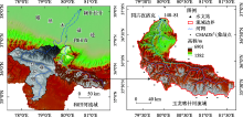
图1
研究区地形及站点分布 注:底图采用自然资源部标准地图制作,审图号为GS(2019)3333号,对底图边界无修改。下同。"
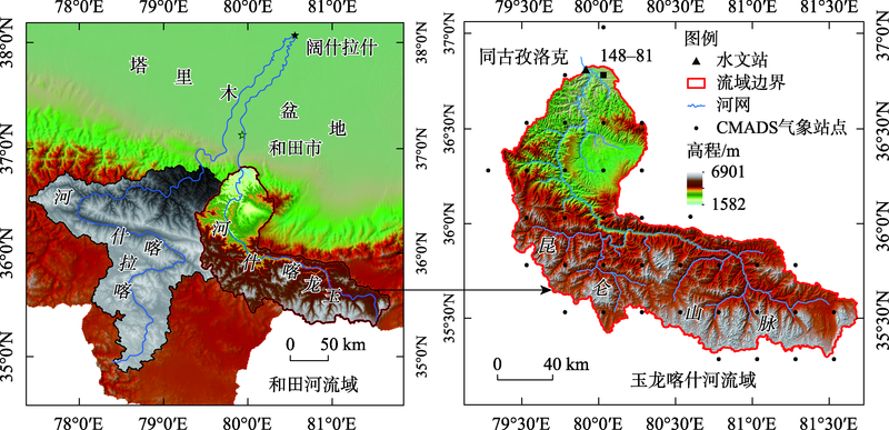
表1
数据类型及来源"
| 数据名称 | 数据描述 | 数据来源 |
|---|---|---|
| 气象数据 | 空间分辨率0.25°,时间为2008—2016年逐日 | 国家青藏高原科学数据中心,数据版本CMADS V1.1 |
| 水文数据 | 1969—2016年逐月径流 | 和田地区水利局,玉龙喀什河出山口同古孜洛克水文站 |
| DEM数字高 程数据 | 空间分辨率30 m,地理坐标为WGS_1984,投影坐标为WGS_1984_World_Mercator | 地理空间数据云ASTER GDEM 30 m分辨率数字高程数据 |
| 土地利用数据 | 空间分辨率30 m,时间为2010年,投影坐标为WGS_1984_World_Mercator | 中国科学院资源环境科学数据中心 |
| 土壤数据 | 空间分辨率1 km,时间为2008年,投影坐标为WGS_1984_World_Mercator | 世界粮农组织提供世界土壤数据库(HWSD)中的中国土壤数据集(V1.2) |
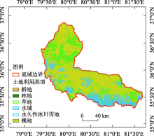
图2
土地利用类型"


图3
土壤类型"
表2
精度评价公式"
| 名称 | 公式 | 范围 | 最优值 |
|---|---|---|---|
| 相关系数(Correlation Coefficient, CC) | | [-1,1] | 1 |
| 均方根误差(Root Mean Square Error,RMSE) | | [0,∞] | 0 |
| 相对误差(Relative Error, RE) | | [-∞,∞] | 0 |
| 探测率(Probability of Detection, POD) | | [0,1] | 1 |
| 误报率(False Alarm Ratio, FAR) | | [0,1] | 0 |
| 临界成功指数(Critical Success Index, CSI) | | [0,1] | 1 |
| 纳什效率系数(Nash-Sutcliffe Efficiency Coefficient,NSE) | | [0,1] | 1 |
| 模型决定系数(Coefficient of Determination, R2) | | [0,1] | 1 |
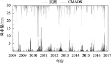
图4
同古孜洛克水文站与CMADS 148-81格点日降水过程对比"
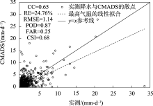
图5
同古孜洛克水文站与CMADS的148-81格点降水散点图"

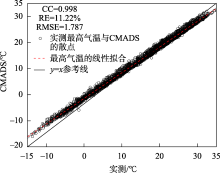
图6
同古孜洛克水文站与CMADS的148-81格点最高气温散点图"

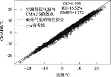
图7
同古孜洛克水文站与CMADS的148-81格点最低气温散点图"
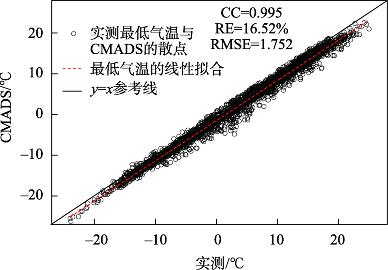

图8
CMADS降水气温时空分布"
表3
参数率定结果"
| 序号 | 调参方式__参数 | 名称 | 调参区间 | 最优值 | t-Stat | P-Value |
|---|---|---|---|---|---|---|
| 1 | V__SMFMX | 最大融雪因子/(mm·℃-1·d-1) | [1.5,6.9] | 5.1345 | 54.7774 | 0.0000 |
| 2 | R__ALPHA_BF | 基流α因子/d | [0,1] | 0.1100 | -25.2418 | 0.0000 |
| 3 | V__SMTMP | 融雪基温/℃ | [-5,10] | 0.5000 | 8.4776 | 0.0000 |
| 4 | V__GW_DELAY | 地下水延迟时间/d | [0,500] | 329.000 | 4.8323 | 0.0000 |
| 5 | A__TLAPS | 气温直减率/(℃·km-1) | [-1.5,0] | -1.5320 | 2.4267 | 0.0154 |
| 6 | R__OV_N | 坡面漫流的曼宁系数 | [-0.2,0.2] | -0.0090 | 2.1911 | 0.0286 |
| 7 | R__CN2 | 初始SCS径流曲线数 | [-0.2,0.2] | -0.1000 | -1.5313 | 0.1259 |
| 8 | R__SOL_BD | 土壤湿容重/(g·cm-3) | [-0.2,0.2] | -0.0278 | -1.4564 | 0.1455 |
| 9 | R__SOL_K | 饱和渗透系数/(mm·h-1) | [-0.5,0.5] | 0.3000 | -1.2161 | 0.2241 |
| 10 | A__PLAPS | 降水直减率/(mm·km-1) | [0,2] | 1.6500 | -1.1239 | 0.2612 |
| 11 | V__RCHRG_DP | 深层含水层的渗透系数 | [0,1] | 0.2480 | 0.7908 | 0.4292 |
| 12 | V__SFTMP | 降雪气温/℃ | [-5,5] | -0.0216 | 0.6371 | 0.5242 |
| 13 | R__HRU_SLP | 平均比降 | [-0.2,0.2] | 0.0587 | -0.5362 | 0.5919 |
| 14 | R__SLSUBBSN | 平均坡长/m | [-0.1,0.1] | 0.0097 | 0.4710 | 0.6377 |
| 15 | V__GWQMN | 发生回归流所需的浅层含水量的水位阀值/mm | [0,5000] | 4750.0 | 0.4302 | 0.6671 |
| 16 | V__SMFMN | 最小融雪因子/(mm·℃-1·d-1) | [1.5,6.9] | 4.4167 | -0.2597 | 0.7951 |
| 17 | V__ESCO | 土壤蒸发补偿因子 | [0,1] | 0.4100 | 0.1570 | 0.8753 |
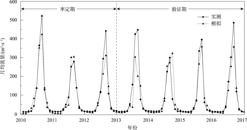
表4
径流模拟评价结果"
| 时期 | 平均值/(m3·s-1) | 纳什系数 | 模型决定系数 | 相对误差 | |
|---|---|---|---|---|---|
| 实测 | 模拟 | ||||
| 率定期 | 93.678 | 86.214 | 0.845 | 0.8562 | -10.93% |
| 验证期 | 89.446 | 78.471 | 0.836 | 0.8153 | -12.47% |
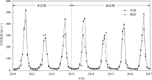
图9
月径流模拟结果"
| [1] | 吴益, 程维明, 任立良, 等. 新疆和田河流域河川径流时序特征分析[J]. 自然资源学报, 2006, 21(5): 375-381. |
| [Wu Yi, Cheng Weiming, Ren Liliang, et al. Analysis on the characteristics of annual runoff in Hotan catchment[J]. Journal of Natural Resource, 2006, 21(5): 375-381.] | |
| [2] |
Yu Z X, Man X L, Duan L L, et al. Assessments of impacts of climate and forest change on water resources using SWAT model in a subboreal watershed in northern Da Hinggan Mountains[J]. Water, 2020, 12(6): 1-15.
doi: 10.3390/w12010001 |
| [3] | 魏冲, 胡彩虹, 陈杰, 等. SWAT模型基于不同坡度林地径流调节作用的实现与应用[J]. 水力发电学报, 2014, 33(3): 98-105, 111. |
| [Wei Chong, Hu Caihong, Chen Jie, et al. Application of SWAT model and realization of hydrological adjusting function of forests on different slopes[J]. Journal of Hydroelectric Engineering, 2014, 33(3): 98-1051, 111.] | |
| [4] | 金鑫, 金彦香, 杨登兴. 基于LU-SWAT模型的土地利用/覆被变化对水文过程的影响研究——以黑河上游为例[J]. 灌溉排水学报, 2019, 38(5): 114-121. |
| [Jin Xin, Jin Yanxiang, Yang Dengxing. Using LU-SWAT Model to analyze the response of hydrological processes to land use/coverage with application to an upper watershed in Heihe Basin[J]. Journal of Irrigation and Drainage, 2019, 38(5): 114-121.] | |
| [5] | 孟现勇, 王浩, 雷晓辉, 等. 基于CMDAS驱动SWAT模式的精博河流域水文相关分量模拟、验证及分析[J]. 生态学报, 2017, 37(21): 7114-7127. |
| [Meng Xianyong, Wang Hao, Lei Xiaohui. et al. Simulation, validation, and analysis of the hydrological components of Jing and Bo River Basin based on the SWAT model driven by CMADS[J]. Acta Ecologica Sinica, 2017, 37(21): 7114-7127.] | |
| [6] |
Liu J, Shangguan D H, Liu S Y, et al. Evaluation and hydrological simulation of CMADS and CFSR reanalysis datasets in the Qinghai-Tibet Plateau[J]. Water, 2018, 10(4): 1-18.
doi: 10.3390/w10020001 |
| [7] |
Zhang L M, Meng X Y, Wang H, et al. Investigate the applicability of CMADS and CFSR reanalysis in Northeast China[J]. Water, 2020, 12(4): 1-18.
doi: 10.3390/w12010001 |
| [8] |
文小航, 吕世华, 董文杰, 等. 西北干旱区绿洲—戈壁资料同化数据集的建立与分析[J]. 高原气象, 2014, 33(1): 66-79.
doi: 10.7522/j.issn.1000-0534.2013.00073 |
|
[Wen Xiaohang, Lyu Shihua, Dong Wenjie, et al. Establish mentand analysis of assimilation dataset of Oasis-Gobi system over an arid region in northwestern China[J]. Plateau Meteorology, 2014, 33(1): 66-79.]
doi: 10.7522/j.issn.1000-0534.2013.00073 |
|
| [9] |
Mokhtari A, Noory H, Vazifedoust M. Performance of different surface incoming solar radiation models and their impacts on reference evapotranspiration[J]. Water Resources Management, 2018, 32(9): 3053-3070.
doi: 10.1007/s11269-018-1974-9 |
| [10] |
赵采玲, 李耀辉, 柳媛普, 等. 中国西北地区大气边界层高度变化特征——基于探空资料与ERA-Interim再分析资料[J]. 高原气象, 2019, 38(6): 1181-1193.
doi: 10.7522/j.issn.1000-0534.2018.00152 |
|
[Zhao Cailing, Li Yaohui, Liu Yuanpu, et al. The variation characteristics of planetary boundary layer height in Northwest China: Based on radiosonde and ERA-Interim reanalysis data[J]. Plateau Meteorology, 2019, 38(6): 1181-1193.]
doi: 10.7522/j.issn.1000-0534.2018.00152 |
|
| [11] | 李锐, 李文卓, 傅云飞, 等. 青藏高原ERA40和NCEP大气非绝热加热的不确定性[J]. 科学通报, 2017, 62(5): 420-431. |
| [Li Rui, Li Wenzhuo, Fu Yunfei, et al. The uncertainties of residual diagnosis of atmospheric diabatic heating from ERA40 and NCEP reanalysis over Tibetan Plateau[J] Chinese Science Bulletin, 2017, 62(5): 420-431.] | |
| [12] | 孟现勇, 师春香, 刘时银, 等. CMADS数据集及其在流域水文模型中的驱动作用——以黑河流域为例[J]. 人民珠江, 2016, 37(7): 1-19. |
| [Meng Xianyong, Shi Chunxiang, Liu Shiyin, et al. CMADS datasets and its application in watershed hydrological simulation: A case study of the Heihe River Basin[J]. Pearl River, 2016, 37(7): 1-19.] | |
| [13] | 张利敏, 王浩, 孟现勇. 基于CMADS驱动的SWAT模型在辽宁浑河流域的应用研究[J]. 华北水利水电大学学报(自然科学版), 2017, 38(5): 1-9. |
| [Zhang Limin, Wang Hao, Meng Xianyong. Application of SWAT model driven by CMADS in Hunhe River Basin in Liaoning Province[J]. Journal of North China University of Water Resources and Electric Power(Natural Science Edition), 2017, 38(5): 1-9.] | |
| [14] |
刘兆晨, 杨梅学, 万国宁, 等. 新型卫星降水产品在黄河源区的适用性分析——以SWAT模型为例[J]. 高原气象, 2021, 40(2): 403-410.
doi: 10.7522/j.issn.1000-0534.2020.00024 |
|
[Liu Zhaochen, Yang Meixue, Wan Guoning, et al. Applicability of new satellites precipitation products in source region of Yellow River: Using SWAT model as an example[J]. Plateau Meteorology, 2021, 40(2): 403-410.]
doi: 10.7522/j.issn.1000-0534.2020.00024 |
|
| [15] | 刘晓笛. 基于SWAT模型的和田河上游气候和土地利用变化的水文效应模拟[D]. 曲阜: 曲阜师范大学, 2019. |
| [Liu Xiaodi. Hydrological Effects of Climate and Land Use Change in the Upper Reaches of Hotan River Based on SWAT Model[D]. Qufu: Qufu Normal University, 2019.] | |
| [16] | 余其鹰, 张江辉, 白云岗, 等. 1957—2018年和田河源流径流演变特征[J]. 干旱区研究, 2021, 38(2): 494-503. |
| [Yu Qiying, Zhang Jianghui, Bai Yungang, et al. Evolution characteristics of the headstream of the Hotan River headstream from 1957 to 2018[J]. Arid Zone Research, 2021, 38(2): 494-503.] | |
| [17] | 黄星, 陈伏龙, 赵琪, 等. 新疆和田河径流丰枯评价及组合分析[J]. 干旱区研究, 2021, 38(6): 1570-1578. |
| [Huang Xing, Chen Fulong, Zhao Qi, et al. Evaluation and combination analysis of runoff in Hotan River, Xinjiang[J]. Arid Zone Research, 2021, 38(6): 1570-1578.] | |
| [18] | 尹如洪. 和田河流域水资源规划研究[D]. 西安: 西安理工大学, 2002. |
| [Yin Ruhong. Study on Water Resources Planning of the Hotan River[D]. Xi’an: Xi’an University of Technology, 2002.] | |
| [19] | 刘启宁, 辛卓航, 韩建旭, 等. 变化环境下东北半干旱地区径流演变规律分析——以洮儿河流域为例[J]. 水力发电学报, 2020, 39(5): 51-63. |
| [Liu Qining, Xin Zhuohang, Han Jianxu, et al. Analysis on evolving trends of streamflow in the semi-arid region in Northeast China under changing environment: A case study of Taoer River basin[J]. Journal of Hydroelectric Engineering, 2020, 39(5): 51-63.] | |
| [20] |
孟现勇, 王浩. SWAT模型中国大气同化驱动数据集(CMADS V1. 1)(2008-2016)[DB/OL]. 国家青藏高原科学数据中心, 2018. DOI: 10.3972/westdc.002.2016.db.CSTR:18046.11.westdc.002.2016.db.
doi: 10.3972/westdc.002.2016.db.CSTR:18046.11.westdc.002.2016.db |
|
[Meng Xianyong, Wang Hao. China Meteorological Assimilation Driving Datasets for the SWAT Model Version1. 1(2008-2016)[DB/OL]. National Tibetan Plateau Data Center, 2018. DOI: 10.3972/westdc.002.2016.db.CSTR:18046.11.westdc.002.2016.db.]
doi: 10.3972/westdc.002.2016.db.CSTR:18046.11.westdc.002.2016.db |
|
| [21] | 屈吉鸿, 石红旺, 李志岩. 基于SWAT模型的青龙河流域气候变化径流响应研究[J]. 水力发电学报, 2015, 34(4): 8-15. |
| [Qu Jihong, Shi Hongwang, Li Zhiyan. Runoff responses to climate change in Qinglong river watershed based on SWAT model[J]. Journal of Hydroelectric Engineering, 2015, 34(4): 8-15.] | |
| [22] |
田晶, 郭生练, 刘德地, 等. 气候与土地利用变化对汉江流域径流的影响[J]. 地理学报, 2020, 75(11): 2307-2318.
doi: 10.11821/dlxb202011003 |
|
[Tian Jing, Guo Shenglian, Liu Dedi, et al. Impacts of climate and land use/cover changes on runoff in the Hanjiang River basin[J]. Acta Geographica Sinica, 2020, 75(11): 2307-2318.]
doi: 10.11821/dlxb202011003 |
|
| [23] | 王中根, 刘昌明, 黄友波. SWAT模型的原理、结构及应用研究[J]. 地理科学进展, 2003, 22(1): 79-86. |
| [Wang Zhonggen, Liu Changming, Huang Youbo. The theory of SWAT model and its application in Heihe Basin[J]. Progress in Geography, 2003, 22(1): 79-86.] | |
| [24] | 庞靖鹏, 徐宗学, 刘昌明. SWAT模型研究应用进展[J]. 水土保持研究, 2007, 14(3): 31-35. |
| [Pang Jingpeng, Xu Zongxue, Liu Changming. SWAT model application: State-of-the-art review[J]. Research of Soil and Water Conservation, 2007, 14(3): 31-35.] | |
| [25] | 张银辉. SWAT模型及其应用研究进展[J]. 地理科学进展, 2005, 24(5): 121-130. |
| [Zhang Yinhui. Development of study on model-SWAT and its application[J]. Progress in Geography, 2005, 24(5): 121-130.] | |
| [26] | Yu J, Noh J, Cho Y. SWAT model calibration/validation using SWAT-CUP Ⅱ: Analysis for uncertainties of simulation run/iteration number[J]. Journal of Korea Water Resources Association, 2020, 53(5): 347-356. |
| [27] |
Mamo K H M, Jain M K. Runoff and sediment modeling using SWAT in Gumera catchment, Ethiopia[J]. Open Journal of Modern Hydrology, 2013, 3(4): 196-205.
doi: 10.4236/ojmh.2013.34024 |
| [28] |
Khalid K, Ali M F, Rahman N F A, et al. Sensitivity analysis in watershed model using SUFI-2 algorithm[J]. Procedia Engineering, 2016, 2(162): 441-447.
doi: 10.1016/j.proeng.2010.03.048 |
| [29] |
Bo H J, Dong X H, Li Z H, et al. Analysis of water balance components and parameter uncertainties based on SWAT model with CMADS data and SUFI-2 algorithm in Huangbaihe River catchment, China[J]. Nature Environment and Pollution Technology, 2020, 19(2): 637-650.
doi: 10.46488/NEPT.2020.v19i02.018 |
| [30] |
Abbaspour K C, Yang J, Maximov I, et al. Modelling of hydrology and water quality in the Pre-Alpine/Alpine thur watershed using SWAT[J]. Journal of Hydrology, 2007, 333(2-4): 413-430.
doi: 10.1016/j.jhydrol.2006.09.014 |
| [31] | 阳宽达, 谢红霞, 隋兵, 等. 基于GIS的降雨空间插值研究——以湖南省为例[J]. 水土保持研究, 2020, 27(3): 134-138, 145. |
| [Yang Kuanda, Xie Hongxia, Sui Bing, et al. Research on spatial interpolation of rainfall based on GIS: A case study of Hunan Province[J]. Research of Soil and Water Conservation, 2020, 27(3): 134-138, 145.] | |
| [32] | 姜卉芳, 穆振侠. 高寒山区气温垂直分布的估测方法研究——以玛纳斯河为例[J]. 水资源与水工程学报, 2011, 22(3): 44-47. |
| [Jiang Huifang, Mu Zhenxia. Research on estimating method on vertical distribution of air temperature at high and cold mountain area: Case of the Manas River[J]. Journal of Water Resources and Water Engineering, 2011, 22(3): 44-47.] | |
| [33] | 荣易, 秦成新, 孙傅, 等. SWAT模型在我国流域水环境模拟应用中的评估验证过程评价[J]. 环境科学研究, 2020, 33(11): 2571-2580. |
| [Rong Yi, Qin Chengxin, Sun Fu, et al. Assessment of evaluation process of SWAT model application in China[J]. Research of Environmental Sciences, 2020, 33(11): 2571-2580.] | |
| [34] | 张玉娜. 基于SWAT模型的干旱区内陆河流域水资源敏感性分析[D]. 乌鲁木齐: 新疆大学, 2014. |
| [Zhang Yu’na. Sensitivity Analysis of Water Resources in Inland River Basin in Arid Area Based on SWAT Model[D]. Urumqi: Xinjiang University, 2014.] | |
| [35] | 尤扬, 李朋朋, 高云. 不同气候情景下和田河上游径流变化[J/OL]. 南水北调与水利科技(中英文): 1-14[2022-03-10]. http://kns.cnki.net/kcms/detail/13.1430.TV.20220222.1636.002.html. |
| You Yang, Li Pengpeng, Gao Yun. Analysis of runoff changes in upper Hotan River under different climate scenarios[J/OL]. South-to-North Water Transfers and Water Science & Technology, 1-14[2022-03-10]. http://kns.cnki.net/kcms/detail/13.1430.TV.20220222.1636.002.html. ] | |
| [36] | 罗开盛, 陶福禄. 基于SWAT的西北干旱区县域水文模拟——以临泽县为例[J]. 生态学报, 2018, 38(23): 8593-8603. |
| [Luo Kaisheng, Tao Fulu. Hydrological modeling based on SWAT in arid Northwest China: A case study in Linze County[J] Acta Ecologica Sinica, 2018, 38(23): 8593-8603.] | |
| [37] | 宋玉鑫, 左其亭, 马军霞. 基于SWAT模型的开都河流域水文干旱变化特征及驱动因子分析[J]. 干旱区研究, 2021, 38(3): 610-617. |
| [Song Yuxin, Zuo Qiting, Ma Junxia. Variation and dynamic drivers of drought in Kaidu River Basin based on the SWAT model[J]. Arid Zone Research, 2021, 38(3): 610-617.] | |
| [38] | 谭丽丽, 黄峰, 乔学瑾, 等. TRMM在海河流域南系的降水估算精度评价及其对SWAT模型的适用性[J]. 农业工程学报, 2020, 36(6): 132-141, 324. |
| [Tan Lili, Huang Feng, Qiao Xuejin, et al. Evaluation of TRMM satellite-based rainfall data in southern Haihe River Basin and suitability for SWAT model[J]. Transactions of the Chinese Society of Agricultural Engineering, 2020, 36(6): 132-141, 324.] | |
| [39] | 莫跃爽, 索惠英, 焦树林, 等. 喀斯特地区降水量空间插值方法对比——以贵州省为例[J]. 水土保持研究, 2021, 28(1): 164-170. |
| [Mo Yueshuang, Suo Huiying, Jiao Shulin, et al. Comparison of spatial interpolation methods of precipitation: A case of Karst Area in Guizhou Province[J]. Research of Soil and Water Conservation, 2021, 28(1): 164-170.] | |
| [40] | 孙铭悦, 吕海深, 朱永华, 等. 2套气象数据在资料缺乏地区的适用性评估——以呼图壁河流域为例[J]. 干旱区研究, 2022, 39(1): 94-103. |
| [Sun Mingyue, Lyu Haishen, Zhu Yonghua, et al. Applicability assessment of two meteorological datasets in areas lacking data with the Hutubi River Basin as an example[J]. Arid Zone Research, 2022, 39(1): 94-103.] | |
| [41] | 祖拜代·木依布拉, 师庆东, 普拉提·莫合塔尔, 等. 基于SWAT模型的乌鲁木齐河上游土地利用和气候变化对径流的影响[J]. 生态学报, 2018, 38(14): 5149-5157. |
| [Zubaida Muyibul, Shi Qindong, Polat Muhtar, et al. Land use and climate change effects on runoff in the upper Urumqi River watershed: A SWAT model based analysis[J]. Acta Ecologica Sinica, 2018, 38(14): 5149-5157.] |
| [1] | 陈爱军,张寅,楚志刚. 基于FY-4A QPE的中亚五国降水时空分布特征[J]. 干旱区研究, 2023, 40(9): 1369-1381. |
| [2] | 李建江,李佳,吴立新,汪赢政,郭磊. 基于高亚洲精细再分析数据模拟普若岗日冰原2012—2014年表面能量-物质平衡[J]. 干旱区研究, 2021, 38(4): 919-929. |
| [3] | 高婧,井立红,秦榕,毛荣,井立军. 新疆塔城地区大-暴雪特征及其与大气环流和海温的关系[J]. 干旱区研究, 2021, 38(2): 359-368. |
|
||