干旱区研究 ›› 2022, Vol. 39 ›› Issue (2): 625-637.doi: 10.13866/j.azr.2022.02.29
邹凯波1( ),张玉虎1(),刘晓伟2,薛淑慧1,杨博文1,崔艳欣1
收稿日期:2021-05-21
修回日期:2021-08-20
出版日期:2022-03-15
发布日期:2022-03-30
通讯作者:
张玉虎
作者简介:邹凯波(1994-),男,硕士研究生,主要从事气候变化与水文模拟研究. E-mail: 基金资助:
ZOU Kaibo1(),ZHANG Yuhu1(),LIU Xiaowei2,XUE Shuhui1,YANG Bowen1,CUI Yanxin1
Received:2021-05-21
Revised:2021-08-20
Online:2022-03-15
Published:2022-03-30
Contact:
Yuhu ZHANG
摘要:
以新疆乌伦古河流域为研究区,基于SWAT模型构建适用于该流域的面源污染分布式水文模型,采用情景设置法设定9种气候变化情景。分析不同气候变化情景对流域径流及面源污染负荷的影响,识别重点影响区域,为流域面源污染防控提供科学依据。结果表明:(1) 径流、总氮和总磷在率定期和验证期的决定系数R2均在0.75以上,纳什系数Ens均在0.55以上,建立的SWAT模型能够用于乌伦古河流域农业面源污染负荷模拟;(2) 增加20%的降水量,径流量增加48.01%、总氮负荷增加23.19%、总磷负荷增加29.65%,气温变化对径流量的影响小于降水量变化对径流量的影响;(3) 各子流域年均单位面积总氮负荷为0.01~164.79 kg·hm-2·a-1,单位面积总磷负荷为0.01~45.10 kg·hm-2·a-1,气候变化对面源污染影响较大区域主要分布在福海县的阿尔达乡、富蕴县的吐尔洪乡、库尔特乡、恰库尔图镇,及青河县的阿热勒乡、阿热勒托别镇、塔克什肯镇等。说明降水增多是乌伦古河流域农业面源污染负荷的主要影响因素之一。未来在农业面源污染防治中应重点控制畜禽养殖和农田径流这两类污染源。
邹凯波,张玉虎,刘晓伟,薛淑慧,杨博文,崔艳欣. 气候变化下乌伦古河流域农业面源污染负荷响应[J]. 干旱区研究, 2022, 39(2): 625-637.
ZOU Kaibo,ZHANG Yuhu,LIU Xiaowei,XUE Shuhui,YANG Bowen,CUI Yanxin. Response of agricultural nonpoint source pollution load in the Ulungur River basin under climate change[J]. Arid Zone Research, 2022, 39(2): 625-637.

图1
乌伦古河流域位置示意图"
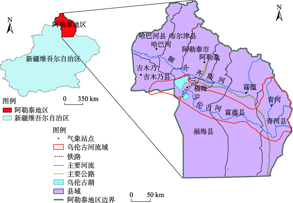
表1
模型构建采用的数据"
| 数据类型 | 分辨率 | 年份 | 格式 | 数据来源 | |
|---|---|---|---|---|---|
| 空间数据 | 流域DEM | 30 m | 2009年 | 栅格 | 地理空间数据云( |
| 土地利用 | 1:250 000 | 2015年 | 栅格 | 清华大学地球系统科学系( | |
| 土壤类型 | 1:1000 000 | 栅格 | HWSD(世界土壤数据库) | ||
| 属性数据 | 气象数据 | 1/3°×1/3° | 2008—2018年 | Txt | CMADS V 1.0大气同化驱动数据集( |
| 土壤属性 | - | - | Excel | HWSD、SPAW | |
| 水文、水质 | - | - | Excel | 阿勒泰水文局 | |
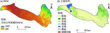
图2
乌伦古河流域DEM和土地利用"

表2
土地利用SWAT重分类结果"
| 土地利用类型编号 | 面积占比/% | SWAT土地利用分类 | 土地类别 |
|---|---|---|---|
| 1 | 3.60 | AGRL | 耕地 |
| 2 | 2.20 | FRST | 林地 |
| 3 | 28.67 | PAST | 草地 |
| 4 | 0.03 | WETL | 湿地 |
| 5 | 1.13 | WATR | 水域 |
| 6 | 64.07 | BARR | 裸地 |
| 7 | 0.30 | URHD | 城镇用地 |
表3
乌伦古河流域土壤类型"
| 土壤类型编号 | 土壤名称 | 面积比例/% | 土壤类型编号 | 土壤名称 | 面积比例/% |
|---|---|---|---|---|---|
| 1 | 简育灰色土 | 1.20 | 18 | 黏化砂性土 | 1.59 |
| 2 | 简育黑钙土 | 0.51 | 19 | 钙积石膏土 | 3.09 |
| 3 | 钙积黑钙土 | 5.11 | 20 | 钙积变性土 | 0.48 |
| 4 | 黏化栗钙土1 | 2.82 | 21 | 石灰性黑土 | 4.25 |
| 5 | 黏化栗钙土2 | 0.03 | 22 | 潜育黑土 | 0.15 |
| 6 | 石灰性冲积土 | 1.05 | 23 | 盐化冲积土 | 0.13 |
| 7 | 简育栗钙土1 | 5.58 | 24 | 松软潜育土 | 0.34 |
| 8 | 钙积栗钙土1 | 5.60 | 25 | 松软盐土1 | 0.08 |
| 9 | 钙积栗钙土2 | 0.09 | 26 | 松软盐土2 | 0.19 |
| 10 | 黏化钙积土1 | 17.43 | 27 | 石膏盐土 | 0.11 |
| 11 | 黏化钙积土2 | 0.20 | 28 | 钙积盐土 | 0.90 |
| 12 | 过渡性红砂土 | 4.13 | 29 | 永冻薄层土 | 2.88 |
| 13 | 干旱土1 | 2.24 | 30 | 饱和薄层土 | 5.84 |
| 14 | 简育砂性土 | 20.27 | 31 | 水体 | 3.71 |
| 15 | 冰冻潜育土 | 4.88 | 32 | 简育栗钙土2 | 0.08 |
| 16 | 干旱土2 | 0.08 | 33 | 永冻雏形土 | 0.01 |
| 17 | 黏化石膏土 | 4.93 | 34 | 简育钙积土 | 0.02 |
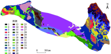
图3
乌伦古河流域土壤类型"

表4
土壤属性数据库相关参数"
| 参数名称 | 含义 | 注释 |
|---|---|---|
| NLAYERS | 土壤分层数 | HWSD |
| HYDGRP | 土壤水文学分组 | 公式计算 |
| SOL_ZMX | 土壤剖面最大根系深度/mm | HWSD |
| ANION_EXCL | 阴离子交换孔隙度 | 模型默认值为0.5 |
| SOL_CRK | 土壤最大可压缩量 | 模型默认值为0.5, 可选 |
| TEXTURE | 土壤层结构 | SPAW计算 |
| SOL_Z | 各土壤层底层到土壤表层的深度/mm | HWSD |
| SOL_BD | 土壤湿密度/(mg·m-3或g·cm-3) | SPAW计算 |
| SOL_AWC | 土壤层有效持水量/mm | SPAW计算 |
| SOL_K | 饱和导水率、饱和水力传导系数/(mm·h-1) | SPAW计算 |
| SOL_CBN | 土壤层中有机碳含量 | HWSD |
| CLAY | 黏土含量(直径<0.002 mm的土壤颗粒) | HWSD |
| SILT | 壤土含量(直径0.002~ 0.05 mm的土壤颗粒) | HWSD |
| SAND | 砂土含量(直径0.05~2.0 mm的土壤颗粒) | HWSD |
| ROCK | 砾石含量(直径>2.0 mm的土壤颗粒) | HWSD |
| SOL_ALB | 地表反射率 | 模型默认值0.01 |
| USLE_K | USLE方程中土壤侵蚀力因子 | 公式计算 |
| SOL_EC | 土壤电导率/(dS·m-1) | 默认为0 |
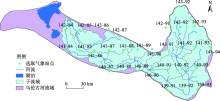
图4
乌伦古河流域内CMADS数据集气象站点分布"

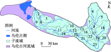
图5
乌伦古河流域子流域划分"

表5
二台站月径流及营养物质模拟评价指标"
| 模拟时段 | 决定系数R2 | 纳什系数Ens | |
|---|---|---|---|
| 径流 | 率定期(2010-05—2016-07) | 0.87 | 0.77 |
| 验证期(2017-04—2018-07) | 0.85 | 0.76 | |
| 总氮 | 率定期(2017-04—2017-07) | 0.86 | 0.86 |
| 验证期(2018-03—2018-07) | 0.85 | 0.87 | |
| 总磷 | 率定期(2017-04—2017-07) | 0.91 | 0.84 |
| 验证期(2018-03—2018-07) | 0.83 | 0.78 |
表6
SWAT模型参数取值"
| 参数名称 | 参数阈值 | 最终取值 | |
|---|---|---|---|
| 径流 | SCS径流曲线系数CN2 | -0.5~0.5 | 0.480 |
| 主河道曼宁系数CH_N2 | -0.5~1 | -0.411 | |
| 土壤蒸发补偿系数ESCO | 0~1 | 0.296 | |
| 最大冠层蓄水量CANMX | 0~100 | 30.650 | |
| 土壤有效水容量SOL_AWC | 0~1 | 0.939 | |
| 饱和水力传导系数SOL_K | 0~1 | 0.502 | |
| 基流退水系数ALPHA_BF | 0.05~24 | 13.450 | |
| 地下水滞留时间系数GW_DELAY | 0~0.3 | 0.012 | |
| 积雪温度滞后因子TIMP | -0.5~0.5 | -0.224 | |
| 土层底部的埋深SOL_Z | 0~500 | 62.750 | |
| 湿土的反照率SOL_ALB | 0~0.25 | 0.034 | |
| 地表径流滞后系数SURLAG | 0~0.5 | 0.304 | |
| 水质(氮循环) | 反硝化指数速率系数CDN | 0~3 | 1.725 |
| 发生反硝化作用的土壤含水量阈值SDNCO | 0~1 | 0.325 | |
| 硝酸盐的渗流系数NPERCO | 0~1 | 0.025 | |
| 泥沙运移中有机氮的富集比ERORGN | 0~5 | 0.125 | |
| 降雨中的氮浓度RCN | 0~15 | 13.875 | |
| NH3生物氧化的速率常数BC1_BSN | 0.1~1 | 0.258 | |
| 从NO2到NO3的生物氧化速率常数BC2_BSN | 0.2~2 | 1.415 | |
| 从有机氮到氨基的水解速率常数BC3_BSN | 0.02~0.4 | 0.239 | |
| 水质(磷循环) | 从有机磷到可溶性磷的腐化速率常数BC4_BSN | 0.01~0.7 | 0.165 |
| 土层中有机磷的起始浓度SOL_ORGP | 0~100 | 22.500 | |
| 磷吸收分布参数P_UPDIS | 0~100 | 17.500 | |
| 磷的土壤分配系数PHOSKD | 100~200 | 122.500 | |
| 磷的可利用率指数PSP | 0.01~0.70 | 0.614 | |
| 泥沙运移中有机磷的富集比ERORGP | 0~5 | 0.125 | |
| 磷渗流系数PPERCO | 10~17.5 | 13.563 |
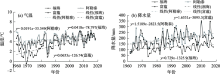
图6
1962—2018年乌伦古河流域气象站点年均气温和降水量变化趋势"

表7
气候变化情景组合"
| 气温变化/℃ | 降水量变化 | ||
|---|---|---|---|
| 0% | +10% | +20% | |
| 0 | S11 | S12 | S13 |
| +1 | S21 | S22 | S23 |
| +2 | S31 | S32 | S33 |
表8
不同情景下流域多年平均径流量及变化百分比"
| 气温 变化/℃ | 降水量变化 | |||
|---|---|---|---|---|
| 0% | +10% | +20% | ||
| 0 | 径流量/(m3·s-1) | 66.05 | 81.29 | 97.76 |
| 变化率/% | 0 | 23.07 | 48.01 | |
| +1 | 径流量/(m3·s-1) | 63.92 | 78.69 | 94.76 |
| 变化率/% | -3.22 | 19.14 | 43.47 | |
| +2 | 径流量/(m3·s-1) | 61.76 | 76.26 | 91.91 |
| 变化率/% | -6.50 | 15.46 | 39.15 | |
表9
不同情景下流域多年平均总氮、总磷负荷量及变化百分比"
| 气温变化/℃ | 降水量变化 | ||||
|---|---|---|---|---|---|
| 0% | 10% | 20% | |||
| 总氮负荷 | 0 | 总氮负荷量/103 t | 10.17 | 11.31 | 12.53 |
| 总氮变化率/% | 0 | 11.25 | 23.19 | ||
| +1 | 总氮负荷量/103 t | 9.98 | 10.98 | 12.15 | |
| 总氮变化率/% | -1.86 | -7.92 | -19.46 | ||
| +2 | 总氮负荷量/103 t | 9.59 | 10.47 | 11.7 | |
| 总氮变化率/% | -5.66 | -2.92 | -15.07 | ||
| 总磷负荷 | 0 | 总磷负荷量/103 t | 1.88 | 2.15 | 2.44 |
| 总磷变化率/% | 0 | 14.32 | 29.65 | ||
| +1 | 总磷负荷量/103 t | 1.82 | 2.07 | 2.35 | |
| 总磷变化率/% | -3.21 | -10.12 | -25.18 | ||
| +2 | 总磷负荷量/103 t | 1.75 | 1.98 | 2.26 | |
| 总磷变化率/% | -7.11 | -5.36 | -20.22 | ||
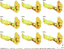
图7
不同气候变化情景下年均单位面积总氮负荷输出空间分布"

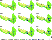
图8
不同气候变化情景下年均单位面积总磷负荷输出空间分布"

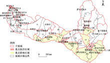
图9
流域农业面源污染区县图"

| [1] | 李秀芬, 朱金兆, 顾晓君, 等. 农业面源污染现状与防治进展[J]. 中国人口·资源与环境, 2010, 20(4):81-84. |
| [ Li Xiufen, Zhu Jinzhao, Gu Xiaojun, et al. Current situation and control of agricultural non-point source pollution[J]. China Population, Resources and Environment, 2010, 20(4):81-84. ] | |
| [2] | Xia T, Chen Z, Jin S. New normal control of agricultural non-point source pollution in the Dianchi Lake basin[J]. Meteorological and Environmental Research, 2017, 8(2):63-72. |
| [3] | 丘雯文, 钟涨宝, 李兆亮, 等. 中国农业面源污染排放格局的时空特征[J]. 中国农业资源与区划, 2019, 40(1):26-34. |
| [ Qiu Wenwen, Zhong Zhangbao, Li Zhaoliang, et al. Spatial-temporal variations of agricultural non-point source pollution in China[J]. China Journal Agricultural Resources and Regional Planning, 2019, 40(1):26-34. ] | |
| [4] | 付磊, 李德山. 中国农业面源污染与绿色全要素生产率的区域差异[J]. 西南科技大学学报(哲学社会科学版), 2021, 38(3):37-48. |
| [ Fu Lei, Li Deshan. Regional differences between of agricultural non-point source pollution and growth of Green TFP in China[J]. Journal of Southwest University of Science and Technology (Philosophy and Social Science Edition), 2021, 38(3):37-48. ] | |
| [5] | 周子渭, 马琼, 侯玉龙, 等. 新疆农业面源污染及环境规制分析[J]. 安徽农业科学, 2021, 49(7):74-76. |
| [ Zhou Ziwei, Ma Qiong, Hou Yulong, et al. Analysis of agricultural non-point source pollution and environmental regulation in Xinjiang[J]. Journal of Anhui Agricultural Sciences, 2021, 49(7):74-76. ] | |
| [6] | 陈亚宁, 杨青, 罗毅, 等. 西北干旱区水资源问题研究思考[J]. 干旱区地理, 2012, 35(1):1-9. |
| [ Chen Yaning, Yang Qing, Luo Yi, et al. Ponder on the issues of water resources in the arid region of Northwest China[J]. Arid Land Geography, 2012, 35(1):1-9. ] | |
| [7] |
李哲, 丁永建, 陈艾姣, 等. 1960—2019年西北地区气候变化中的Hiatus现象及特征[J]. 地理学报, 2020, 75(9):1845-1859.
doi: 10.11821/dlxb202009003 |
|
[ Li Zhe, Ding Yongjian, Chen Aijiao, et al. Characteristics of warming hiatus of the climate change in Northwest China from 1960 to 2019[J]. Acta Geographica Sinica, 2020, 75(9):1845-1859. ]
doi: 10.11821/dlxb202009003 |
|
| [8] | 施雅风, 沈永平, 胡汝骥. 西北气候由暖干向暖湿转型的信号、影响和前景初步探讨[J]. 冰川冻土, 2002, 24(3):219-226. |
| [ Shi Yafeng, Shen Yongping, Hu Ruji. Preliminary study on the signals, impact and foreground of climatic shift from warm-dry to warm-humid in Northwest China[J]. Journal of Glaciology and Geocryology, 2002, 24(3):219-226. ] | |
| [9] | 李江, 龙爱华. 近60 a新疆水资源变化及可持续利用思考[J]. 水利规划与设计, 2021, 34(7):1-5. |
| [ Li Jiang, Long Aihua. Changes in Xinjiang water resources in the past 60 years and considerations on sustainable utilization[J]. Water Resources Planning and Design, 2021, 34(7):1-5. ] | |
| [10] | 李慧菁, 贾尔恒·阿哈提, 程艳. 乌伦古湖流域污染负荷估算[J]. 环境工程技术学报, 2015, 5(2):121-128. |
| [ Li Huijing, Jiaerheng Ahati, Cheng Yan. Estimation of pollution load in Ulungur Lake Basin[J]. Journal of Environmental Engineering Technology, 2015, 5(2):121-128. ] | |
| [11] | 徐伟. 乌伦古河流域非点源污染负荷估算探讨[J]. 能源与节能, 2021, 2(1):91-92. |
| [ Xu Wei. Discussion on estimation of non-point source pollution load in Ulungur river basin[J]. Energy and Energy Conservation, 2021, 2(1):91-92. ] | |
| [12] | Romagnoli M, Portapila M, Rigalli A, et al. Assessment of the SWAT model to simulate a watershed with limited available data in the Pampas region, Argentina[J]. Science of the Total Environment, 2017, 596(597):437-450. |
| [13] |
Grizzetti B, Bouraoui F, Granlund K, et al. Modelling diffuse emission and retention of nutrients in the Vantaanjoki watershed (Finland) using the SWAT model[J]. Ecological Modelling, 2003, 169(1):25-38.
doi: 10.1016/S0304-3800(03)00198-4 |
| [14] | 薛亚婷, 孙文锦, 邹长武, 等. 基于模型的赤水河流域面源污染研究[J]. 亚热带资源与环境学报, 2020, 15(3):17-23. |
| [ Xue Yating, Sun Wenjin, Zou Changwu, et al. Study on non-point source pollution in Chishui River Watershed based on SWAT model[J]. Journal of Subtropical Resources and Environment, 2020, 15(3):17-23. ] | |
| [15] | 付意成, 臧文斌, 董飞, 等. 基于模型的浑太河流域农业面源污染物产生量估算[J]. 农业工程学报, 2016, 32(8):1-8. |
| [ Fu Yicheng, Zang Wenbin, Dong Fei, et al. Yield calculation of agricultural non-point source pollutants in Huntai river basin based on SWAT model[J]. Transactions of the Chinese Society of Agricultural Engineering, 2016, 32(8):1-8. ] | |
| [16] | 王晓燕, 秦福来, 欧洋, 等. 基于SWAT模型的流域非点源污染模拟——以密云水库北部流域为例[J]. 农业环境科学学报, 2008, 27(3):1098-1105. |
| [ Wang Xiaoyan, Qin Fulai, Ou Yang, et al. SWAT-based simulation on non-point source pollution in the northern watershed of Miyun reservoi[J]. Journal of Agro-Environmental Sciences, 2008, 27(3):1098-1105. ] | |
| [17] | 马睿, 程凯, 郭莹莹, 等. 基于SWAT模型的石汶河流域农业非点源氮污染时空分布特征研究[J]. 中国水土保持, 2020, 15(7):61-64. |
| [ Ma Rui, Cheng Kai, Guo Yingying, et al. Research on temporal and spatial distribution characteristics of agricultural non-point source nitrogen pollution in Shiwen River Basin based on SWAT model[J]. Soil and Water Conservation in China, 2020, 15(7):61-64. ] | |
| [18] | Wang Y, Bian J, Zhao Y, et al. Assessment of future climate change impacts on nonpoint source pollution in snowmelt period for a cold area using SWAT[J]. Scientific Reports, 2018, 8(1):1-13. |
| [19] | 刘吉开, 万甜, 程文, 等. 未来气候情境下渭河流域陕西段非点源污染负荷响应[J]. 水土保持通报, 2018, 38(4):82-86. |
| [ Liu Jikai, Wan Tian, Cheng Wen, et al. Effects of climate scenarios on non-point source pollution load on Shaanxi section of Weihe river basin[J]. Bulletin of Soil and Water Conservation, 2018, 38(4):82-86. ] | |
| [20] | 赵雪松. 气候变化对营口地区农业面源污染影响的定量评估研究[J]. 水土保持应用技术, 2019, 39(4):16-18. |
| [ Zhao Xuesong. Quantitative assessment of the impact of climate change on agricultural non-point source pollution in Yingkou area[J]. Technology of Soil and Water Conservation, 2019, 39(4):16-18. ] | |
| [21] | 李家科, 刘健, 秦耀民, 等. 基于SWAT模型的渭河流域非点源氮污染分布式模拟[J]. 西安理工大学学报, 2008, 31(3):278-285. |
| [ Li Jiake, Liu Jian, Qin Yaomin, et al. Distributed simulation on nitrogen non-point source pollution in the Weihe river watershed based on SWAT model[J]. Journal of Xi’an University of Technology, 2008, 31(3):278-285. ] | |
| [22] | 宋玉鑫, 左其亭, 马军霞. 基于SWAT模型的开都河流域水文干旱变化特征及驱动因子分析[J]. 干旱区研究, 2021, 38(3):610-617. |
| [ Song Yuxin, Zuo Qiting, Ma Junxia. Hydrological drought characteristics and driving factors analysis of the Kaidu River Basin based on SWAT model[J]. Arid Zone Research, 2021, 38(3):610-617. ] | |
| [23] | 矫桂丽, 刘洪林, 孙秀玲, 等. 基于SWAT模型的尼山水库流域面源污染特征分析[J]. 山东农业大学学报(自然科学版), 2021, 52(3):470-474. |
| [ Jiao Guili, Liu Honglin, Sun Xiuling, et al. Analysis of non-point source pollution characteristics of Nishan Reservoir based on SWAT model[J]. Journal of Shandong Agricultural University (Natural Science Edition), 2021, 52(3):470-474. ] | |
| [24] | 杨宝林, 崔远来, 赵树君, 等. 基于SWAT模型的莲塘口流域农业面源污染模拟[J]. 武汉大学学报(工学版), 2016, 49(3):359-364. |
| [ Yang Baolin, Cui Yuanlai, Zhao Shujun, et al. Simulation and application of agricultural non-point source pollution in Liantangkou watershed based on SWAT model[J]. Journal of Wuhan University(Engineering and Technology Edition), 2016, 49(3):359-364. ] | |
| [25] | 张鹏飞. 不同气候条件下密云水库流域非点源污染评价[D]. 北京: 首都师范大学, 2013. |
| [ Zhang Pengfei. Non-point Source Pollution Assessment of the Miyun Reservoir Basin under Different Climatic Conditions[D]. Beijing: Capital Normal University, 2013. ] |
| [1] | 赵雨琪, 魏天兴. 1990—2020年黄土高原典型县域植被覆盖变化及影响因素[J]. 干旱区研究, 2024, 41(1): 147-156. |
| [2] | 胡广录,陶虎,焦娇,白元儒,陈海志,麻进. 黑河中游正义峡径流变化趋势及归因分析[J]. 干旱区研究, 2023, 40(9): 1414-1424. |
| [3] | 周小东, 常顺利, 王冠正, 张毓涛, 喻树龙, 张同文. 天山北坡中段雪岭云杉径向生长对气候变化的响应[J]. 干旱区研究, 2023, 40(8): 1215-1228. |
| [4] | 孟乘枫, 仲涛, 郑江华, 王南, 刘泽轩, 任祥源. 昆仑山冰湖分布时空特征及驱动力[J]. 干旱区研究, 2023, 40(7): 1094-1106. |
| [5] | 赵艳芬, 潘伯荣. 气候变化情景下革苞菊属在中国的潜在地理分布[J]. 干旱区研究, 2023, 40(6): 949-957. |
| [6] | 姚春艳, 刘洪鹄, 刘竞. 长江源区1980—2020年水沙变化规律[J]. 干旱区研究, 2023, 40(5): 726-736. |
| [7] | 赵美亮, 曹广超, 赵青林, 曹生奎. 气候及土地利用变化对大通河源区水文要素空间分布的影响[J]. 干旱区研究, 2023, 40(3): 381-391. |
| [8] | 戴君, 胡海珠, 毛晓敏, 张霁. 基于CMIP6多模式预估数据的石羊河流域未来气候变化趋势分析[J]. 干旱区研究, 2023, 40(10): 1547-1562. |
| [9] | 姚岱均, 刘康, 惠俞翔, 王凯欣. 天水麦积山油松树轮宽度对气候变化的响应及其机制[J]. 干旱区研究, 2023, 40(1): 19-29. |
| [10] | 陈红光, 孟凡浩, 萨楚拉, 罗敏, 王牧兰, 刘桂香. 北方牧区草原内陆河流域径流演变特征及其驱动因素分析[J]. 干旱区研究, 2023, 40(1): 39-50. |
| [11] | 张昊琛,萨楚拉,孟凡浩,罗敏,王牧兰,高红豆. 内蒙古地表冻融指数动态变化与驱动因素分析[J]. 干旱区研究, 2022, 39(6): 1996-2008. |
| [12] | 王靖文,唐志光,邓刚,胡国杰,桑国庆. 1991—2021年天山融雪末期雪线高度遥感监测研究[J]. 干旱区研究, 2022, 39(5): 1385-1397. |
| [13] | 郭伊利,李书恒,王嘉川,韩宜洁. 芦芽山华北落叶松早晚材径向生长对气候变化响应的分离效应[J]. 干旱区研究, 2022, 39(5): 1449-1463. |
| [14] | 王晓飞,黄粤,刘铁,李均力,王正,昝婵娟,段永超. 近60 a伊塞克湖水量平衡变化及影响因素分析[J]. 干旱区研究, 2022, 39(5): 1576-1587. |
| [15] | 张赟鑫,郝海超,范连连,李耀明,张仁平,李凯辉. 中亚草地NPP时空动态及其驱动因素研究[J]. 干旱区研究, 2022, 39(3): 698-707. |
|
||