干旱区研究 ›› 2021, Vol. 38 ›› Issue (5): 1442-1451.doi: 10.13866/j.azr.2021.05.27
满元伟( ),李净(),邢立亭
收稿日期:2021-01-11
修回日期:2021-03-03
出版日期:2021-09-15
发布日期:2021-09-24
通讯作者:
李净
作者简介:满元伟(1995-),男,硕士研究生,主要从事定量遥感与农业干旱研究. E-mail: 基金资助:
MAN Yuanwei(),LI Jing(),XING Liting
Received:2021-01-11
Revised:2021-03-03
Online:2021-09-15
Published:2021-09-24
Contact:
Jing LI
摘要:
干旱在全球范围内产生了深远的社会和经济影响,可靠的干旱监测对防旱抗旱工作具有重要指导意义。由于在植被覆盖度和农作物种植率较低区域使用植被状态或单因子进行干旱监测时精度较低,故本文采用地表温度(LST)、降水量(P)和土壤湿度(SM)数据,基于三维欧氏几何空间中欧氏距离方法构建了一种新的干旱指数:温度-土壤湿度-降水干旱指数(TMPDI)用于干旱监测。并以甘肃省为研究区,利用SPI、SPEI、遥感数据以及小麦单位面积单产对TMPDI进行验证。结果表明:TMPDI与SPI、SPEI高度相关(R2>0.64),且在干旱监测中兼顾降水量与气温影响的同时,降低了使用降水量或地表温度进行干旱监测的不确定性,提高了土壤湿度在农业干旱监测中的准确性与有效性,能准确地描述干旱事件的时空演变特征,同时也能较好地反映出干旱强度与干旱面积率的变化对小麦产量造成的影响,说明TMPDI在农业干旱监测中具有较高的有效性和可靠性。
满元伟,李净,邢立亭. 基于多源遥感数据的温度-土壤湿度-降水干旱指数(TMPDI)的构建与应用[J]. 干旱区研究, 2021, 38(5): 1442-1451.
MAN Yuanwei,LI Jing,XING Liting. Development and application of the temperature soil moisture precipitation drought index (TMPDI) based on multi-source remote sensing data[J]. Arid Zone Research, 2021, 38(5): 1442-1451.
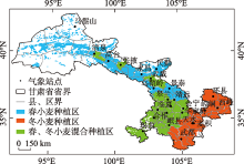
图1
研究区示意图"
表1
遥感干旱指数与SPI、SPEI的相关系数"
| 遥感干旱指数 | SPI | SPEI |
|---|---|---|
| SMCI | 0.426 | 0.375 |
| TCI | 0.375 | 0.447 |
| PCI | 0.696 | 0.615 |
| TMPDI | 0.632 | 0.611 |
图2
2000—2018年甘肃省TMPDI与SPI、SPEI变化特征"
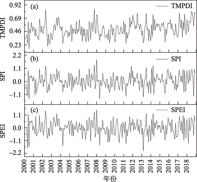
表2
TMPDI的干旱等级划分"
| 干旱等级 | SPI | SPEI | TMPDI |
|---|---|---|---|
| 无旱 | -0.5<SPI | -0.5<SPEI | 0.45<TMPDI |
| 轻旱 | -1.0<SPI≤-0.5 | -1.0<SPEI≤-0.5 | 0.35<TMPDI≤0.45 |
| 中旱 | -1.5<SPI≤-1.0 | -1.5<SPEI≤-1.0 | 0.25<TMPDI≤0.35 |
| 重旱 | -2.0<SPI≤-1.5 | -2.0<SPEI≤-1.5 | 0.15<TMPDI≤0.25 |
| 特旱 | SPI≤-2.0 | SPEI≤-2.0 | TMPDI≤0.15 |
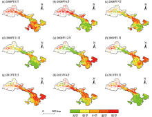
图3
甘肃省TMPDI干旱监测分布"

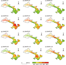
图4
甘肃省TMPDI干旱监测分布"

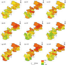
图5
2000—2018年冬小麦单产与TMPDI的相关性分布 注:1—6月为冬小麦收割年,10—12月为冬小麦种植年。"

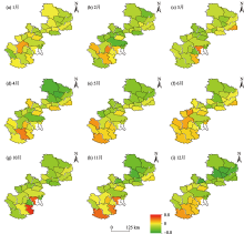
图6
2000—2018年冬小麦单产与干旱面积率的相关性分布 注:1—6月为冬小麦收割年,10—12月为冬小麦种植年。"

表3
春小麦主要种植县区的小麦单产与干旱强度和干旱面积率相关性"
| 3月 | 4月 | 5月 | 6月 | 7月 | ||
|---|---|---|---|---|---|---|
| 民乐县 | TMPDI | 0.135 | 0.059 | 0.437 | 0.624** | 0.231 |
| 干旱面积率 | -0.105 | -0.062 | -0.407 | -0.546* | -0.313 | |
| 山丹县 | TMPDI | 0.315 | 0.099 | 0.383 | 0.543* | 0.248 |
| 干旱面积率 | -0.275 | -0.052 | -0.405 | -0.425 | -0.318 | |
| 天祝县 | TMPDI | 0.177 | 0.399* | 0.403 | 0.136 | 0.013 |
| 干旱面积率 | 0 | -0.350* | -0.368 | -0.086 | 0.009 | |
| 民勤县 | TMPDI | 0.182 | -0.283 | -0.004 | -0.275 | 0.084 |
| 干旱面积率 | 0.121 | -0.340 | 0.050 | -0.216 | 0.174 | |
| 永昌县 | TMPDI | -0.046 | -0.064 | 0.252 | 0.493* | 0.085 |
| 干旱面积率 | 0.022 | -0.011 | -0.152 | -0.451* | -0.289 | |
| 靖远县 | TMPDI | 0.178 | 0 | -0.232 | 0.024 | -0.102 |
| 干旱面积率 | 0.004 | 0.077 | 0.174 | 0.003 | 0.096 | |
| 景泰县 | TMPDI | 0.049 | -0.177 | 0.299 | 0.041 | 0.165 |
| 干旱面积率 | -0.120 | 0.144 | -0.392 | -0.109 | 0.031 |
| [1] |
Liu X, Zhu X, Pan Y, et al. Agricultural drought monitoring: Progress, challenges, and prospects[J]. Journal of Geographical Sciences, 2016, 26(6): 750-767.
doi: 10.1007/s11442-016-1297-9 |
| [2] | Du L, Tian Q, Yu T, et al. A comprehensive drought monitoring method integrating MODIS and TRMM data[J]. International Journal of Applied Earth Observation & Geoinformation, 2013, 23: 245-253. |
| [3] |
Yu F, Price K P, Ellis J, et al. Response of seasonal vegetation development to climatic variations in eastern central Asia[J]. Remote Sensing of Environment, 2003, 87(1): 42-54.
doi: 10.1016/S0034-4257(03)00144-5 |
| [4] | 孙博, 钱静, 陈曦, 等. 常见遥感干旱监测指标在哈萨克斯坦的一致性分析[J]. 干旱区研究, 2020, 37(3): 663-670. |
| [ Sun Bo, Qian Jing, Chen Xi, et al. Consistency and comparison among remote sensing drought indices and SMAP soil moisture in Kazakhstan[J]. Arid Zorn Research, 2020, 37(3): 663-670. ] | |
| [5] | Potopová V, Trnka M, Hamouz P, et al. Statistical modelling of drought-related yield losses using soil moisture-vegetation remote sensing and multiscalar indices in the south-eastern Europe[J]. Agricultural Water Management, 2020, 236: 1-18. |
| [6] |
Hwang T, Gholizadeh H, Sims D A, et al. Capturing species-level drought responses in a temperate deciduous forest using ratios of photochemical reflectance indices between sunlit and shaded canopies[J]. Remote Sensing of Environment, 2017, 199: 350-359.
doi: 10.1016/j.rse.2017.07.033 |
| [7] | 程文举, 席海洋, 司建华, 等. 河西内陆河浅山区流域蒸散发估算及干旱特性研究[J]. 干旱区研究, 2020, 37(5): 1105-1115. |
| [ Cheng Wenju, Xi Haiyang, Si Jianhua, et al. Study of evapotranspiration estimation and drought characteristics of watershed in low coteau area of Hexi inland river[J]. Arid Zone Research, 2020, 37(5): 1105-1115. ] | |
| [8] | McKee T B, Doesken N J, Kleist J. The relationship of drought frequency and duration to time scales[J]. Eighth Conference on Applied Climatology, Anaheim, 1993: 17-24. |
| [9] |
Vicente-Serrano S M, Santiago B, López-Moreno J I. A multiscalar drought index sensitive to global warming: The standardized precipitation evapotranspiration index[J]. Journal of Climate, 2010, 23(7): 1696-1718.
doi: 10.1175/2009JCLI2909.1 |
| [10] | Palmer W C. Meteorological Drought (Research Paper No. 45)[R]. Washington: US Department of Commerce, Weather Bureau, 1965: 45-58. |
| [11] | Bhuiyan C, Singh R P, Kogan F N. Monitoring drought dynamics in the Aravalli region (India) using different indices based on ground and remote sensing data[J]. International Journal of Applied Earth Observation & Geoinformation, 2006, 8(4): 289-302. |
| [12] | Kogan F N. Application of vegetation index and brightness temperature for drought detection[J]. Advances in Space Research, 1995, 15(11): 91-100. |
| [13] | Du L, Tian Q, Yu T, et al. A comprehensive drought monitoring method integrating MODIS and TRMM data[J]. International Journal of Applied Earth Observation & Geoinformation, 2013, 23: 245-253. |
| [14] |
Kogan F N, Stark R, Gitelson A, et al. Derivation of pasture biomass in Mongolia from AVHRR-based vegetation health indices[J]. International Journal of Remote Sensing, 2004, 25(14), 2889-2896.
doi: 10.1080/01431160410001697619 |
| [15] |
Sandholt I, Rasmussen K, Andersen J. A simple interpretation of the surface temperature/vegetation index space for assessment of surface moisture status[J]. Remote Sensing of Environment, 2002, 79 (2-3): 213-224.
doi: 10.1016/S0034-4257(01)00274-7 |
| [16] |
Zhang A, Jia G. Monitoring meteorological drought in semiarid regions using multi-sensor microwave remote sensing data[J]. Remote Sensing of Environment, 2013, 134: 12-23.
doi: 10.1016/j.rse.2013.02.023 |
| [17] |
Campbell B M, Vermeulen S J, Aggarwal P K, et al. Reducing risks to food security from climate change[J]. Global Food Security, 2016, 11: 34-43.
doi: 10.1016/j.gfs.2016.06.002 |
| [18] | 韩兰英, 张强, 赵红岩, 等. 甘肃省农业干旱灾害损失特征及其对气候变暖的响应[J]. 中国沙漠, 2016, 36(3) : 767-776. |
| [ Han Lanying, Zhang Qiang, Zhao Hongyan, et al. The characteristics of agricultural drought disaster loss and response to climate warming in Gansu, China[J]. Journal of Desert Research, 2016, 36(3): 767-776. ] | |
| [19] | 中国气象局. 中国气象灾害年鉴(2004)[M]. 北京: 气象出版社, 2005. |
| [ China Meteorological Administration. Yearbook of Meteorological Disasters in China 2004[M]. Beijing: China Meteorological Press, 2005. ] | |
| [20] | Wei W, Pang S, Wang X, et al. Temperature Vegetation Precipitation Dryness Index (TVPDI)-based dryness-wetness monitoring in China[J]. Remote Sensing of Environment, 2020, 248: 1-18. |
| [21] | 刘德祥, 白虎志, 宁惠芳, 等. 气候变暖对甘肃干旱气象灾害的影响[J]. 冰川冻土, 2006, 28(5): 707-712. |
| [ Liu Dexiang, Bai Huzhi, Ning Huifang, et al. Response of arid meteorological disaster to climatic warming in Gansu Province[J]. Journal of Glaciology and Geocryology, 2006, 28(5): 707-712. ] | |
| [22] |
Ye L, Fang L, Shi Z, et al. Spatio-temporal dynamics of soil moisture driven by ‘Grain for Green’ program on the Loess Plateau, China[J]. Agriculture Ecosystems & Environment, 2019, 269: 204-214.
doi: 10.1016/j.agee.2018.10.006 |
| [23] |
Loon A V. Hydrological drought explained[J]. WIREs Water, 2015, 2: 359-392.
doi: 10.1002/wat2.2015.2.issue-4 |
| [24] | Qi L A, Sha Z A, Hz C, et al. Monitoring drought using composite drought indices based on remote sensing[J]. Science of The Total Environment, 2020, 711: 1-10. |
| [25] |
Mesquita D, Gomes J, Junior A S, et al. Euclidean distance estimation in incomplete datasets[J]. Neurocomputing, 2017, 248: 11-18.
doi: 10.1016/j.neucom.2016.12.081 |
| [26] |
Amani M, Salehi B, Mahdavi S, et al. Temperature-Vegetation-soil Moisture Dryness Index (TVMDI)[J]. Remote Sensing of Environment, 2017, 197: 1-14.
doi: 10.1016/j.rse.2017.05.026 |
| [27] | 张强, 邹旭恺, 肖风劲, 等.气象干旱等级(GB/T 20481-2006)[S]. 北京: 中国标准出版社, 2006: 12-17. |
| [ Zhang Qiang, Zou Xukai, Xiao Fengjin, et al. Classification of Meteorological Drought Category (GB/T20481-2006)[S]. Beijing: Standards Press of China, 2006: 12-17. ] | |
| [28] | 甘肃省地方史志办公室. (甘肃年鉴2019)[M]. 兰州: 甘肃民族出版社, 2019. |
| [Office of Local Chronicles of Gansu Province. Gansu Yearbook 2019[M]. Lanzhou: Gansu Nationalities Publishing House, 2019. ] | |
| [29] |
Mishra A K, Singh V P. A review of drought concepts[J]. Journal of Hydrology, 2010, 391(1-2): 202-216.
doi: 10.1016/j.jhydrol.2010.07.012 |
| [30] |
Daryanto S, Wang L, Jacinthe P A. Global synthesis of drought effects on cereal, legume, tuber and root crops production: A review[J]. Agricultural Water Management, 2016, 179: 18-33.
doi: 10.1016/j.agwat.2016.04.022 |
| [31] |
余慧倩, 张强, 孙鹏, 等. 干旱强度及发生时间对华北平原五省冬小麦产量影响[J]. 地理学报, 2019, 74(1): 87-102.
doi: 10.11821/dlxb201901007 |
|
[ Yu Huiqian, Zhang Qiang, Sun Peng, et al. Impacts of drought intensity and drought duration on winter wheat yield in five provinces of north China plain[J]. Acta Geographica Sinica, 2019, 74(1): 87-102. ]
doi: 10.11821/dlxb201901007 |
|
| [32] |
Çakir R. Effect of water stress at different development stages on vegetative and reproductive growth of corn[J]. Field Crops Research, 2004, 89(1): 1-16.
doi: 10.1016/j.fcr.2004.01.005 |
| [33] |
Wang S, Mo X, Liu S, et al. Validation and trend analysis of ECV soil moisture data on cropland in North China Plain during 1981-2010[J]. International Journal of Applied Earth Observation and Geoinformation, ,2015,, 48: 110-121.
doi: 10.1016/j.jag.2015.10.010 |
| [34] | Anyamba A, Tucker C J. Historical perspectives on AVHRR NDVI and vegetation drought monitoring[J]. NASA Publications, 2012, 217. http://digitalcommons.unl.edu/nasapub/217. |
| [35] |
Loon A V, Laaha G. Hydrological drought severity explained by climate and catchment characteristics[J]. Journal of Hydrology, 2015, 526: 3-14.
doi: 10.1016/j.jhydrol.2014.10.059 |
| [1] | 陈春波,李均力,赵炎,夏江,田伟涛,李超锋. 新疆草地时空动态及其对气候变化的响应——以昌吉回族自治州为例[J]. 干旱区研究, 2023, 40(9): 1484-1497. |
| [2] | 马瑶瑶, 史培军, 徐伟, 张钢锋. 干旱区水电站建设运营生态环境影响遥感监测[J]. 干旱区研究, 2023, 40(9): 1498-1508. |
| [3] | 孟乘枫, 仲涛, 郑江华, 王南, 刘泽轩, 任祥源. 昆仑山冰湖分布时空特征及驱动力[J]. 干旱区研究, 2023, 40(7): 1094-1106. |
| [4] | 刘笑, 郭鹏, 祁佳峰, 杜文玲, 张茹倩, 张坤. 基于MRSEI模型的阿勒泰市生态环境时空变化及驱动力分析[J]. 干旱区研究, 2023, 40(6): 1014-1026. |
| [5] | 李菲菲, 周霞, 周玉玺. 西北地区农业干旱脆弱性评估及时空分布特征[J]. 干旱区研究, 2023, 40(4): 663-669. |
| [6] | 康利刚, 曹生奎, 曹广超, 杨羽帆, 严莉, 王有财. 青海湖沙柳河流域蒸散发时空变化特征[J]. 干旱区研究, 2023, 40(3): 358-372. |
| [7] | 张雨斯,包玉海,贺忠华. 1990—2021年内蒙古遥感生态环境质量变化及趋势分析——以呼伦贝尔市陈巴尔虎旗为例[J]. 干旱区研究, 2023, 40(2): 326-336. |
| [8] | 吴万民, 刘涛, 陈鑫. 西北干旱半干旱区NDVI季节性变化及其影响因素[J]. 干旱区研究, 2023, 40(12): 1969-1981. |
| [9] | 李炎坤,高黎明,张乐乐,吴雪晴,刘轩辰,祁闻. 青海湖流域及周边区域TRMM 3B43降水数据降尺度方法对比分析[J]. 干旱区研究, 2022, 39(6): 1706-1716. |
| [10] | 王靖文,唐志光,邓刚,胡国杰,桑国庆. 1991—2021年天山融雪末期雪线高度遥感监测研究[J]. 干旱区研究, 2022, 39(5): 1385-1397. |
| [11] | 王姣妍. 基于MSWEP降水产品的新疆干旱时空特征分析[J]. 干旱区研究, 2022, 39(5): 1398-1409. |
| [12] | 阮永健,吴秀芹. 基于GRACE和GLDAS的西北干旱区地下水资源量可持续性评价[J]. 干旱区研究, 2022, 39(3): 787-800. |
| [13] | 程梦园,曹广超,赵美亮,刁二龙,何启欣,高斯远,邱巡巡,程国. 香日德-柴达木河流域土壤湿度时空变化特征及其影响因素[J]. 干旱区研究, 2022, 39(2): 615-624. |
| [14] | 陈春波,彭建,李刚勇. 新疆草地生态系统健康评价体系构建[J]. 干旱区研究, 2022, 39(1): 270-281. |
| [15] | 王晓燕,李净,邢立亭. 基于3种机器学习方法的农业干旱监测比较[J]. 干旱区研究, 2022, 39(1): 322-332. |
|
||